The M46 9 postcode sector is within the county of Greater Manchester.
Did you know? According to the 2021 Census, the M46 9 postcode sector is home to a bustling 11,766 residents!
Given that each sector allows for 400 unique postcode combinations. Letters C, I, K, M, O and V are not allowed in the last two letters of a postcode. With 292 postcodes already in use, this leaves 108 units available.
The M46 9 postal code covers the settlement of Atherton.
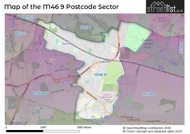
The M46 9 Postcode shares a border with BL5 2 (Westhoughton), BL5 3 (Westhoughton), M29 8 (Tyldesley), M46 0 (Atherton) and BL5 1 (BOLTON, Over Hulton).
The sector is within the post town of MANCHESTER.
M46 9 is a postcode sector within the M46 postcode district which is within the M Manchester postcode area.
The Royal Mail delivery office for the M46 9 postal sector is the Atherton Delivery Office.
The area of the M46 9 postcode sector is 1.42 square miles which is 3.68 square kilometres or 909.29 square acres.

Map of the M46 9 Postcode Sector
Explore the M46 9 postcode sector by using our free interactive map.
| M | 4 | 6 | - | 9 | X | X |
| M | 4 | 6 | Space | 9 | Letter | Letter |
Official List of Streets
Atherton (206 Streets)
Unofficial Streets or Alternative Spellings
Atherton
CRAB TREE LANE HAMILTON STREET LEE STREET MARKET STREET NORTH CROFT NORTH ROAD ROSEDALE AVENUE SECOND AVENUE WATER STREET AMBERGATE BACK SHORT STREET BOND STREET BREEZE HILL CHAPEL STREET GREEN HALL CLOSE HILL CREST HOLLAND STREET MASON LANE MAYFAIR DRIVE MILL STREET PARK STREET REGENT STREET ROWLAND STREET SAINT MARYS CLOSE WINDSOR STREET WOODHOUSE STREETTyldesley
ENGINE LANESchools and Places of Education Within the M46 9 Postcode Sector
Chowbent Primary School
Voluntary controlled school
Laburnum Street, Manchester, , M46 9FP
Head: Mr James Randle
Ofsted Rating: Good
Inspection: 2019-12-12 (1624 days ago)
Website: Visit Chowbent Primary School Website
Phone: 01942883410
Number of Pupils: 153
Hindsford CofE Primary School
Voluntary controlled school
Lodge Road, Manchester, , M46 9BL
Head: Mrs Elaine Holden
Ofsted Rating: Outstanding
Inspection: 2014-03-06 (3731 days ago)
Website: Visit Hindsford CofE Primary School Website
Phone: 01942882409
Number of Pupils: 198
Rowan Tree Primary School
Community special school
Green Hall Close, Manchester, Lancashire, M46 9HP
Head: Mrs Louise Curran
Ofsted Rating: Outstanding
Inspection: 2017-09-13 (2444 days ago)
Website: Visit Rowan Tree Primary School Website
Phone: 01942883928
Number of Pupils: 117
Sacred Heart RC Primary School
Voluntary aided school
Lodge Lane, Manchester, , M46 9BN
Head: Mr Ian McDermott
Ofsted Rating: Good
Inspection: 2022-03-03 (812 days ago)
Website: Visit Sacred Heart RC Primary School Website
Phone: 01942883429
Number of Pupils: 183
St Philip's CofE Primary School, Atherton
Voluntary aided school
Bolton Old Road, Manchester, Greater Manchester, M46 9FD
Head: Miss L Rigby
Ofsted Rating: Good
Inspection: 2023-11-09 (196 days ago)
Website: Visit St Philip's CofE Primary School, Atherton Website
Phone: 01942883919
Number of Pupils: 413
House Prices in the M46 9 Postcode Sector
| Type of Property | 2018 Average | 2018 Sales | 2017 Average | 2017 Sales | 2016 Average | 2016 Sales | 2015 Average | 2015 Sales |
|---|---|---|---|---|---|---|---|---|
| Detached | £262,745 | 17 | £233,760 | 25 | £226,473 | 26 | £214,638 | 27 |
| Semi-Detached | £132,855 | 97 | £135,833 | 74 | £127,107 | 67 | £123,558 | 68 |
| Terraced | £89,744 | 54 | £90,352 | 66 | £87,463 | 60 | £92,509 | 47 |
| Flats | £48,333 | 3 | £69,500 | 7 | £72,708 | 6 | £54,475 | 2 |
Important Postcodes M46 9 in the Postcode Sector
M46 9BL is the postcode for Hindsford C of E School, Lodge Road, Atherton, and Hindsford C of E School, Lodge Road
M46 9EY is the postcode for Formby Hall, Alder Street
M46 9FD is the postcode for EXTENSION TO FORM 2FE COMPLETED NOV 2013, St. Philips C of E Primary School, Bolton Old Road, and St. Philips C of E Primary School, Bolton Old Road
M46 9FP is the postcode for Chowbent Primary School, Laburnum Street, Chowbent School, Laburnum Street, and Chowbent School, Laburnum Street, Atherton
M46 9HP is the postcode for MAIN SCHOOL, Rowan Tree Primary School, Greenhall Close, and Rowan Tree Primary School, Greenhall Close
M46 9JH is the postcode for Atherton Library, York Street
| The M46 9 Sector is within these Local Authorities |
|
|---|---|
| The M46 9 Sector is within these Counties |
|
| The M46 9 Sector is within these Water Company Areas |
|