The BL5 3 postcode sector is within the county of Greater Manchester.
Did you know? According to the 2021 Census, the BL5 3 postcode sector is home to a bustling 12,379 residents!
Given that each sector allows for 400 unique postcode combinations. Letters C, I, K, M, O and V are not allowed in the last two letters of a postcode. With 329 postcodes already in use, this leaves 71 units available.
The BL5 3 postal code covers the settlement of Westhoughton.
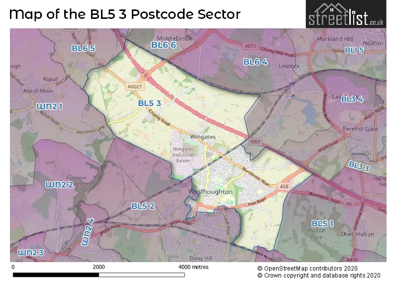
The BL5 3 Postcode shares a border with BL5 2 (Westhoughton), BL6 5 (Blackrod, Horwich), WN2 1 (Aspull, WIGAN, Haigh), BL3 4 (BOLTON), BL5 1 (BOLTON, Over Hulton), BL6 4 (Lostock), BL6 6 (Horwich) and M46 9 (Atherton).
The sector is within the post town of BOLTON.
BL5 3 is a postcode sector within the BL5 postcode district which is within the BL Bolton postcode area.
The Royal Mail delivery office for the BL5 3 postal sector is the Bolton West Delivery Office.
The area of the BL5 3 postcode sector is 4.29 square miles which is 11.12 square kilometres or 2,748.62 square acres.
The BL5 3 postcode sector is crossed by the M61 motorway.
Waterways within the BL5 3 postcode sector include the Hall Lee Brook.

Map of the BL5 3 Postcode Sector
Explore the BL5 3 postcode sector by using our free interactive map.
| B | L | 5 | - | 3 | X | X |
| B | L | 5 | Space | 3 | Letter | Letter |
Official List of Streets
Westhoughton (231 Streets)
BOLTON (1 Streets)
Unofficial Streets or Alternative Spellings
Westhoughton
GREEN MEADOWS LEIGH ROAD LONG LANE NEW FIELD COURT POPLAR GROVE SCHOOL STREETLostock
CHEW MOOR LANE CHULSEY GATE LANE COPPICE CLOSE LOSTOCK LANE BACK ALBION STREET BACK BOLTON ROAD BACK CHORLEY ROAD BACK CHURCH LANE BACK CHURCH ROAD BACK CHURCH STREET BACK DIXON STREET BACK FIELDBROOK WALK BACK GRUNDY STREET BACK HENRY STREET BACK HOWARTH STREET BACK JAMES STREET BACK KING STREET BACK MANCHESTER ROAD BACK MILL STREET BACK PARK ROAD BACK PEEL STREET BACK SEDDON STREET BACK WESLEY STREET BACK WHITTLES TERRACE BACK WIGAN ROAD BACK WOOD STREET BACK WOOD STREET (WEST) BALFERN CLOSE BANK HEY BROAD WALK CHEQUERBENT ROUNDABOUT CHURNETT CLOSE CHURNETT GROVE CODE LANE COOPS YARD DURRINGTON PLACE FAIRHAVEN DRIVE FELL FOOT MEADOW HEATLEY GARDENS HERBERT STREET HIGHER DAMSHEAD HORWICH LINK INTERCHANGE HUNGER HILL INTERCHANGE KINGS STREET LOSTOCK ROAD METAL BOX WAY NORRIS ROAD PUNCH LANE SAINT JOHNS AVENUE SAINT JOHNS COURT SNYDALE WAY SNYDLE WAY THE MORETONS THE OLD BAKERY TRINITY PLACE WESTHOUGHTON ROAD WIEND HALL WIMBERRY HILL ROAD WOODVALEOver Hulton
MANCHESTER ROADBlackrod
MANCHESTER ROADAtherton
NORTH ROADHorwich
DE HAVILLAND WAYAspull
DICCONSON LANEWeather Forecast for BL5 3
Press Button to Show Forecast for Westhoughton
| Time Period | Icon | Description | Temperature | Rain Probability | Wind |
|---|---|---|---|---|---|
| 06:00 to 09:00 | Partly cloudy (day) | 4.0°C (feels like 2.0°C) | 1.00% | ENE 4 mph | |
| 09:00 to 12:00 | Cloudy | 7.0°C (feels like 5.0°C) | 5.00% | E 4 mph | |
| 12:00 to 15:00 | Overcast | 9.0°C (feels like 7.0°C) | 9.00% | E 4 mph | |
| 15:00 to 18:00 | Cloudy | 10.0°C (feels like 9.0°C) | 6.00% | E 4 mph | |
| 18:00 to 21:00 | Cloudy | 9.0°C (feels like 8.0°C) | 6.00% | E 7 mph | |
| 21:00 to 00:00 | Cloudy | 7.0°C (feels like 5.0°C) | 8.00% | ENE 7 mph |
Press Button to Show Forecast for Westhoughton
| Time Period | Icon | Description | Temperature | Rain Probability | Wind |
|---|---|---|---|---|---|
| 00:00 to 03:00 | Partly cloudy (night) | 5.0°C (feels like 3.0°C) | 5.00% | E 7 mph | |
| 03:00 to 06:00 | Partly cloudy (night) | 5.0°C (feels like 2.0°C) | 5.00% | ENE 7 mph | |
| 06:00 to 09:00 | Partly cloudy (day) | 5.0°C (feels like 3.0°C) | 5.00% | ENE 7 mph | |
| 09:00 to 12:00 | Cloudy | 7.0°C (feels like 5.0°C) | 8.00% | E 9 mph | |
| 12:00 to 15:00 | Overcast | 9.0°C (feels like 7.0°C) | 14.00% | E 9 mph | |
| 15:00 to 18:00 | Cloudy | 10.0°C (feels like 8.0°C) | 17.00% | E 9 mph | |
| 18:00 to 21:00 | Cloudy | 9.0°C (feels like 7.0°C) | 16.00% | ENE 9 mph | |
| 21:00 to 00:00 | Cloudy | 8.0°C (feels like 5.0°C) | 17.00% | ENE 9 mph |
Press Button to Show Forecast for Westhoughton
| Time Period | Icon | Description | Temperature | Rain Probability | Wind |
|---|---|---|---|---|---|
| 00:00 to 03:00 | Cloudy | 7.0°C (feels like 4.0°C) | 14.00% | ENE 9 mph | |
| 03:00 to 06:00 | Cloudy | 7.0°C (feels like 4.0°C) | 20.00% | NE 9 mph | |
| 06:00 to 09:00 | Overcast | 7.0°C (feels like 5.0°C) | 22.00% | NE 9 mph | |
| 09:00 to 12:00 | Cloudy | 9.0°C (feels like 7.0°C) | 19.00% | NE 9 mph | |
| 12:00 to 15:00 | Heavy rain | 10.0°C (feels like 8.0°C) | 76.00% | NE 9 mph | |
| 15:00 to 18:00 | Heavy rain | 11.0°C (feels like 9.0°C) | 75.00% | NNE 9 mph | |
| 18:00 to 21:00 | Light rain shower (day) | 10.0°C (feels like 8.0°C) | 41.00% | N 9 mph | |
| 21:00 to 00:00 | Partly cloudy (night) | 9.0°C (feels like 7.0°C) | 14.00% | N 7 mph |
Schools and Places of Education Within the BL5 3 Postcode Sector
Sacred Heart R.C. Primary School
Voluntary aided school
Central Drive, Bolton, Lancashire, BL5 3DU
Head: Mr Martin Johnson
Ofsted Rating: Outstanding
Inspection: 2012-03-14 (4426 days ago)
Website: Visit Sacred Heart R.C. Primary School Website
Phone: 01942634681
Number of Pupils: 418
St Bartholomew's CofE Primary School
Voluntary aided school
The Fairways, Bolton, Lancashire, BL5 3NZ
Head: Mr Mark Johns
Ofsted Rating: Good
Inspection: 2020-02-12 (1535 days ago)
Website: Visit St Bartholomew's CofE Primary School Website
Phone: 01942634717
Number of Pupils: 212
St Thomas CofE Primary School
Voluntary aided school
Molyneux Road, Bolton, Lancashire, BL5 3HP
Head: Gina Linney
Ofsted Rating: Good
Inspection: 2022-03-09 (779 days ago)
Website: Visit St Thomas CofE Primary School Website
Phone: 01942634666
Number of Pupils: 240
The Gates Primary School
Community school
Bristle Hall Way, Bolton, Lancashire, BL5 3QA
Head: Mr Sean Doherty
Ofsted Rating: Good
Inspection: 2023-09-21 (218 days ago)
Website: Visit The Gates Primary School Website
Phone: 01942634734
Number of Pupils: 317
Westhoughton High School
Community school
Bolton Road, Bolton, Lancashire, BL5 3BZ
Head: Mr Neil Coe
Ofsted Rating: Requires improvement
Inspection: 2023-05-11 (351 days ago)
Website: Visit Westhoughton High School Website
Phone: 01942814122
Number of Pupils: 1327
House Prices in the BL5 3 Postcode Sector
| Type of Property | 2018 Average | 2018 Sales | 2017 Average | 2017 Sales | 2016 Average | 2016 Sales | 2015 Average | 2015 Sales |
|---|---|---|---|---|---|---|---|---|
| Detached | £275,730 | 58 | £237,031 | 57 | £223,491 | 57 | £220,337 | 50 |
| Semi-Detached | £165,214 | 64 | £153,121 | 66 | £134,462 | 52 | £132,875 | 57 |
| Terraced | £123,783 | 100 | £123,608 | 107 | £114,393 | 89 | £115,174 | 93 |
| Flats | £92,821 | 17 | £84,007 | 28 | £74,293 | 14 | £71,676 | 27 |
Important Postcodes BL5 3 in the Postcode Sector
BL5 3AT is the postcode for Bolton Metropolitan Borough Council, Westhoughton Library, Library Street
BL5 3AW is the postcode for Westhoughton Town Hall, Market Street, Westhoughton, and Westhoughton Area Office, Town Hall, Market Street
BL5 3BZ is the postcode for Westhoughton High School, Bolton Road, C & E BLOCK, Westhoughton High School, Bolton Road, MAIN BUILDING, Westhoughton High School, Bolton Road, and B Block, Westhoughton High School, Bolton Road
BL5 3DU is the postcode for Sacred Heart RC Primary School, Central Drive
BL5 3HP is the postcode for St Thomas Chequerbent C Of E Primary School, Molyneux Road, Westhoughton, and St. Thomas C of E Primary School, Molyneux Road
BL5 3NG is the postcode for Rainbow House, 1 Trackside Approach
BL5 3NZ is the postcode for BLOCK 2, St. Bartholomew's CE Primary, The Fairways, and St. Bartholomew's CE Primary, The Fairways
BL5 3QA is the postcode for The Gates Primary School, Bristle Hall Way
BL5 3SF is the postcode for Stable Fold Surgery, 119 Church Street
BL5 3UB is the postcode for The Unsworth Group Practice, Peter House, Captain Lees Road
| The BL5 3 Sector is within these Local Authorities |
|
|---|---|
| The BL5 3 Sector is within these Counties |
|
| The BL5 3 Sector is within these Water Company Areas |
|