The NG9 6 postcode sector stands on the Derbyshire and Nottinghamshire border.
Did you know? According to the 2021 Census, the NG9 6 postcode sector is home to a bustling 9,056 residents!
Given that each sector allows for 400 unique postcode combinations. Letters C, I, K, M, O and V are not allowed in the last two letters of a postcode. With 220 postcodes already in use, this leaves 180 units available.
The largest settlement in the NG9 6 postal code is Toton followed by Beeston, and Attenborough.
The NG9 6 Postcode shares a border with NG9 5 (Beeston, Attenborough), NG9 7 (Stapleford), NG10 1 (Long Eaton), NG11 0 (Gotham, Ratcliffe-on-Soar, Barton-in-Fabis), NG11 8 (NOTTINGHAM, Clifton Village, Clifton), NG9 1 (Beeston) and NG10 2 (Long Eaton).
The sector is within the post town of NOTTINGHAM.
NG9 6 is a postcode sector within the NG9 postcode district which is within the NG Nottingham postcode area.
The Royal Mail delivery office for the NG9 6 postal sector is the Beeston Delivery Office.
The area of the NG9 6 postcode sector is 2.36 square miles which is 6.11 square kilometres or 1,510.38 square acres.
Waterways within the NG9 6 postcode sector include the River Trent, River Erewash, The Brook.

Map of the NG9 6 Postcode Sector
Explore the NG9 6 postcode sector by using our free interactive map.
| N | G | 9 | - | 6 | X | X |
| N | G | 9 | Space | 6 | Letter | Letter |
Official List of Streets
Beeston (48 Streets)
Attenborough (32 Streets)
Toton (83 Streets)
Unofficial Streets or Alternative Spellings
Beeston
BYE PASS ROAD CHETWYND ROAD HARTILL CLOSE HOLMFIELD ROAD LAVELLE COURT MEADOW LANE NORBETT CLOSE NORTHFIELD CRESCENT NORTHFIELD ROAD TOPLIFF ROADAttenborough
CROFTON ROAD GLENDALE COURT RIVERDALE ROAD BARRATT LANE CROSSING NO.2 (DIVERTED) BODY ROAD BROADSTAIRS ROAD BROOKSIDE PATH CHURCH CRESCENT CHURCH PATH DAVIS ROAD GREENWAY TRAIL GREGSON ROAD HILL ROAD HILL VIEW ROAD HOWELL-JONES ROAD LAUREN GROVE MAIN PATH NILSSON ROAD RIVINGTON ROAD THE BUND THE COURT WET MARSH PATH WHITTAKER ROAD WOODSTOCK COURTToton
CARTER ROAD DOUGLAS COURTStapleford
TOTON LANE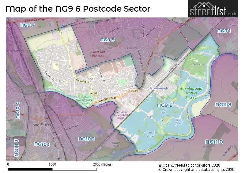
House Prices in the NG9 6 Postcode Sector
| Type of Property | 2018 Average | 2018 Sales | 2017 Average | 2017 Sales | 2016 Average | 2016 Sales | 2015 Average | 2015 Sales |
|---|---|---|---|---|---|---|---|---|
| Detached | £277,555 | 81 | £292,014 | 69 | £252,303 | 86 | £273,843 | 90 |
| Semi-Detached | £208,054 | 55 | £194,485 | 47 | £174,002 | 56 | £163,937 | 59 |
| Terraced | £181,725 | 16 | £170,191 | 11 | £170,035 | 13 | £142,167 | 9 |
| Flats | £112,088 | 16 | £98,648 | 20 | £99,396 | 12 | £106,423 | 12 |
Important Postcodes NG9 6 in the Postcode Sector
NG9 6DX is the postcode for Chilwell Meadows Surgery, Ranson Road
NG9 6FW is the postcode for Chetwynd Primary Academy, Chetwynd Road, and Chetwynd Primary Academy, Chetwynd Road, Toton
NG9 6GJ is the postcode for BISPHAM DRIVE JUNIOR SCHOOL, BISPHAM DRIVE, TOTON, Bispham Drive Junior School, Bispham Drive, Beeston, and Bispham Drive Junior School, Bispham Drive
NG9 6HE is the postcode for Banks Road Infant School, Banks Road, Beeston, and Banks Road Infant School, Banks Road
| The NG9 6 Sector is within these Local Authorities |
|
|---|---|
| The NG9 6 Sector is within these Counties |
|
| The NG9 6 Sector is within these Water Company Areas |
|