The S66 postcode district is a postal district located in the S Sheffield postcode area with a population of 46,292 residents according to the 2021 England and Wales Census.
The area of the S66 postcode district is 24.73 square miles which is 64.05 square kilometres or 15,826.19 acres.
Currently, the S66 district has about 1079 postcode units spread across 6 geographic postcode sectors.
Given that each sector allows for 400 unique postcode combinations, the district has a capacity of 2,400 postcodes. With 1079 postcodes already in use, this leaves 1321 units available.
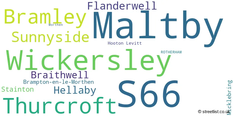
The largest settlement in the S66 postal code is Maltby followed by Wickersley, and Bramley.
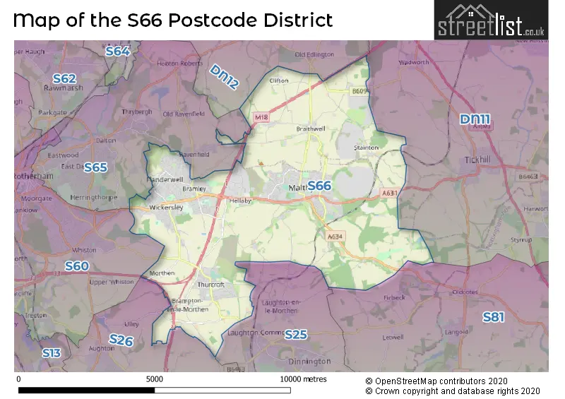
The S66 Postcode shares a border with S25 (Dinnington, North Anston, South Anston), S26 (Swallownest, Aston, Kiveton Park), S65 (ROTHERHAM, Thrybergh, Ravenfield), DN11 (New Rossington, Harworth, Tickhill), DN12 (Conisbrough, Edlington, Denaby Main) and S81 (WORKSOP, Carlton-in-Lindrick, Langold).
The primary settlement in the S66 postcode district is Rotherham, located in the county of South Yorkshire in England. Other significant settlements in the district include Bramley, Wickersley, Flanderwell, Sunnyside, Braithwell, Maltby, Stainton, Hellaby, Hooton Levitt, Brampton-en-le-Morthen, Morthen, and Thurcroft. The most significant postal town in the district is Rotherham.
For the district S66, we have data on 7 postcode sectors. Here's a breakdown: The sector S66 1, covers Wickersley and Bramley in South Yorkshire. The sector S66 2, covers Wickersley and Bramley and Flanderwell in South Yorkshire. The sector S66 3, covers Sunnyside and Bramley in South Yorkshire. The sector S66 6 is non-geographic. It's often designated for PO Boxes, large organisations, or special services. The sector S66 7, covers Maltby and Braithwell in South Yorkshire. The sector S66 8, covers Maltby and Hellaby in South Yorkshire. The sector S66 9, covers Thurcroft in South Yorkshire.

Map of the S66 Postcode District
Explore the S66 postcode district by using our free interactive map.
When it comes to local government, postal geography often disregards political borders. However, for a breakdown in the S66 District: the district mostly encompasses the Rotherham District (B) (1029 postcodes), and finally, the Doncaster District (B) area (59 postcodes).
Recent House Sales in S66
| Date | Price | Address |
|---|---|---|
| 06/10/2023 | £170,000 | Main Street, Bramley, Rotherham, S66 2SF |
| 06/10/2023 | £168,000 | Companions Close, Wickersley, Rotherham, S66 1BL |
| 22/09/2023 | £257,000 | Holyrood Rise, Bramley, Rotherham, S66 3QB |
| 19/09/2023 | £70,000 | John Street, Thurcroft, Rotherham, S66 9HJ |
| 15/09/2023 | £75,000 | Nelson Road, Maltby, Rotherham, S66 7PL |
| 12/09/2023 | £74,000 | The Crescent West, Sunnyside, Rotherham, S66 3RE |
| 08/09/2023 | £232,500 | Parkstone Crescent, Hellaby, Rotherham, S66 8HD |
| 08/09/2023 | £120,000 | Elder Drive, Sunnyside, Rotherham, S66 3PW |
| 05/09/2023 | £120,000 | Searby Road, Bramley, Rotherham, S66 3XX |
| 01/09/2023 | £85,000 | Queen Mary Street, Maltby, Rotherham, S66 7JB |
Weather Forecast for S66
Press Button to Show Forecast for Maltby
| Time Period | Icon | Description | Temperature | Rain Probability | Wind |
|---|---|---|---|---|---|
| 03:00 to 06:00 | Clear night | 2.0°C (feels like -1.0°C) | 1.00% | NNW 4 mph | |
| 06:00 to 09:00 | Sunny day | 2.0°C (feels like 0.0°C) | 1.00% | NNW 4 mph | |
| 09:00 to 12:00 | Sunny day | 6.0°C (feels like 5.0°C) | 1.00% | NE 4 mph | |
| 12:00 to 15:00 | Overcast | 8.0°C (feels like 7.0°C) | 9.00% | ENE 4 mph | |
| 15:00 to 18:00 | Cloudy | 9.0°C (feels like 7.0°C) | 10.00% | ENE 4 mph | |
| 18:00 to 21:00 | Cloudy | 7.0°C (feels like 5.0°C) | 11.00% | E 7 mph | |
| 21:00 to 00:00 | Partly cloudy (night) | 5.0°C (feels like 4.0°C) | 7.00% | NE 4 mph |
Press Button to Show Forecast for Maltby
| Time Period | Icon | Description | Temperature | Rain Probability | Wind |
|---|---|---|---|---|---|
| 00:00 to 03:00 | Partly cloudy (night) | 4.0°C (feels like 3.0°C) | 7.00% | NE 4 mph | |
| 03:00 to 06:00 | Cloudy | 3.0°C (feels like 1.0°C) | 11.00% | NNE 4 mph | |
| 06:00 to 09:00 | Cloudy | 3.0°C (feels like 1.0°C) | 11.00% | NNE 4 mph | |
| 09:00 to 12:00 | Cloudy | 8.0°C (feels like 5.0°C) | 11.00% | ENE 7 mph | |
| 12:00 to 15:00 | Overcast | 9.0°C (feels like 7.0°C) | 20.00% | ENE 9 mph | |
| 15:00 to 18:00 | Cloudy | 10.0°C (feels like 8.0°C) | 18.00% | ENE 9 mph | |
| 18:00 to 21:00 | Cloudy | 9.0°C (feels like 6.0°C) | 20.00% | ENE 9 mph | |
| 21:00 to 00:00 | Cloudy | 6.0°C (feels like 4.0°C) | 17.00% | NE 9 mph |
Press Button to Show Forecast for Maltby
| Time Period | Icon | Description | Temperature | Rain Probability | Wind |
|---|---|---|---|---|---|
| 00:00 to 03:00 | Light rain | 6.0°C (feels like 3.0°C) | 48.00% | NNE 9 mph | |
| 03:00 to 06:00 | Light rain | 6.0°C (feels like 3.0°C) | 50.00% | NNE 11 mph | |
| 06:00 to 09:00 | Heavy rain | 7.0°C (feels like 4.0°C) | 79.00% | NNE 11 mph | |
| 09:00 to 12:00 | Heavy rain | 8.0°C (feels like 5.0°C) | 79.00% | NNE 11 mph | |
| 12:00 to 15:00 | Heavy rain | 9.0°C (feels like 6.0°C) | 78.00% | NNE 11 mph | |
| 15:00 to 18:00 | Light rain | 9.0°C (feels like 7.0°C) | 52.00% | NNW 11 mph | |
| 18:00 to 21:00 | Overcast | 9.0°C (feels like 7.0°C) | 22.00% | N 9 mph | |
| 21:00 to 00:00 | Partly cloudy (night) | 7.0°C (feels like 5.0°C) | 10.00% | SSE 7 mph |
Where is the S66 Postcode District?
The S66 postcode district is located in Rotherham. It is in close proximity to several nearby towns, including Mexborough to the North West (5.74 miles away), Doncaster to the North East (7.56 miles away), Worksop to the South East (9.60 miles away), Sheffield to the West (12.34 miles away), Dronfield to the South West (13.33 miles away), and Pontefract to the North (17.00 miles away). Additionally, the S66 postcode district is approximately 140.09 miles away from the center of London.
The district is within the post town of ROTHERHAM.
The sector has postcodes within the nation of England.
The S66 Postcode District is in the Barnsley, Doncaster and Rotherham region of South Yorkshire within the Yorkshire and The Humber.
| Postcode Sector | Delivery Office |
|---|---|
| S66 1 | Rotherham Delivery Office |
| S66 2 | Rotherham Delivery Office |
| S66 3 | Rotherham Delivery Office |
| S66 7 | Maltby Delivery Office |
| S66 8 | Maltby Delivery Office |
| S66 9 | Rotherham Delivery Office |
| S | 6 | 6 | - | X | X | X |
| S | 6 | 6 | Space | Numeric | Letter | Letter |
Tourist Attractions within the Postcode Area
We found 1 visitor attractions within the S66 postcode area
| Roche Abbey |
|---|
| Historic Properties |
| Historic Monument / Archaeological Site |
| View Roche Abbey on Google Maps |
Current Monthly Rental Prices
| # Bedrooms | Min Price | Max Price | Avg Price |
|---|---|---|---|
| 1 | £675 | £675 | £675 |
| 2 | £525 | £1,200 | £750 |
| 3 | £675 | £1,100 | £845 |
| 5 | £477 | £2,200 | £935 |
Current House Prices
| # Bedrooms | Min Price | Max Price | Avg Price |
|---|---|---|---|
| £1 | £450,000 | £249,167 | |
| 1 | £39,950 | £210,000 | £134,988 |
| 2 | £45,000 | £350,000 | £167,872 |
| 3 | £40,000 | £1,000,000 | £246,641 |
| 4 | £140,000 | £780,000 | £386,099 |
| 5 | £375,000 | £1,500,000 | £699,500 |
| 6 | £425,000 | £1,250,000 | £968,750 |
| 9 | £1,500,000 | £1,500,000 | £1,500,000 |
Estate Agents who Operate in the S66 District
| Logo | Name | Brand Name | Address | Contact Number | Total Properties |
|---|---|---|---|---|---|
 | Rotherham | Lincoln Ralph | London House Clifford Lister Business Centre Bawtry Road Wickersley Rotherham S66 2BL | 01709 212513 | 27 |
 | Maltby | William H. Brown | 54 High Street, Maltby, Rotherham, S66 8LA | 01709 212534 | 25 |
 | Wickersley | Eadon Lockwood & Riddle | 149 Bawtry Road, Wickersley, Rotherham, S66 2BW | 01709 288878 | 21 |
 | Rotherham | Blundells | 204 Bawtry Road, Wickersley, Rotherham, S66 1AA | 01709 212540 | 20 |
 | Maltby Ltd | Merryweathers | Merryweathers Maltby Ltd, 114 High Street Maltby S66 7BN | 01709 212521 | 12 |
| Type of Property | 2018 Average | 2018 Sales | 2017 Average | 2017 Sales | 2016 Average | 2016 Sales | 2015 Average | 2015 Sales |
|---|---|---|---|---|---|---|---|---|
| Detached | £254,992 | 203 | £231,695 | 286 | £244,806 | 320 | £222,039 | 285 |
| Semi-Detached | £137,272 | 274 | £131,016 | 288 | £128,946 | 302 | £123,648 | 277 |
| Terraced | £87,082 | 170 | £90,853 | 170 | £98,733 | 175 | £93,051 | 149 |
| Flats | £105,675 | 32 | £119,851 | 34 | £144,115 | 74 | £86,891 | 32 |