The S8 0 postcode sector is within the county of South Yorkshire.
Did you know? According to the 2021 Census, the S8 0 postcode sector is home to a bustling 10,670 residents!
Given that each sector allows for 400 unique postcode combinations. Letters C, I, K, M, O and V are not allowed in the last two letters of a postcode. With 219 postcodes already in use, this leaves 181 units available.
The S8 0 postal code covers the settlement of SHEFFIELD.
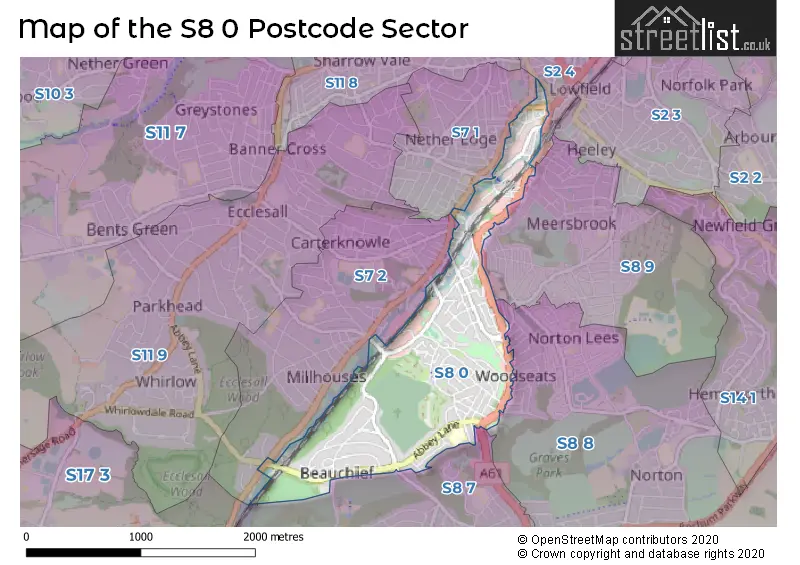
The S8 0 Postcode shares a border with S2 4 (SHEFFIELD), S7 1 (SHEFFIELD), S7 2 (SHEFFIELD), S8 7 (SHEFFIELD), S8 8 (SHEFFIELD), S8 9 (SHEFFIELD) and S17 3 (SHEFFIELD, Dore, Totley Rise).
The sector is within the post town of SHEFFIELD.
S8 0 is a postcode sector within the S8 postcode district which is within the S Sheffield postcode area.
The Royal Mail delivery office for the S8 0 postal sector is the Sheffield Scale Payment Delivery Office.
The area of the S8 0 postcode sector is 1.05 square miles which is 2.71 square kilometres or 670.85 square acres.
Waterways within the S8 0 postcode sector include the River Sheaf.

Map of the S8 0 Postcode Sector
Explore the S8 0 postcode sector by using our free interactive map.
| S | 8 | - | 0 | X | X |
| S | 8 | Space | 0 | Letter | Letter |
Official List of Streets
SHEFFIELD (115 Streets)
Unofficial Streets or Alternative Spellings
SHEFFIELD
ABBEY CRESCENT ABBEYDALE ROAD AISTHORPE ROAD ALBERT ROAD BEAUCHIEF ABBEY LANE BEAUCHIEF GROVE BINFIELD ROAD BOCKING LANE BROXHOLME ROAD BUTTERMERE ROAD CHANTREY ROAD COBNAR ROAD DERBYSHIRE LANE HAUGHTON ROAD HELMTON ROAD LONDON ROAD MEERSBROOK AVENUE MEERSBROOK PARK ROAD MILLMOUNT ROAD NETTLEHAM ROAD NEWLYN ROAD OLD STATION DRIVE OLIVET ROAD TROUTBECK ROAD UNDERWOOD ROAD VALLEY ROAD WOODBANK CRESCENT WOODSEATS HOUSE ROAD BEDALE ROAD BROADFIELD WAY CATMELL COURT DENTON ROAD HALLS COURT HEELEY RETAIL PARK LITTLE LONDON PLACE MARRIOTT LANE MEADOWHEAD MILLER ROAD PRIMROSE WALK RIVER SHEAF WALK RYDAL CRESENT THE MEWS WINDSOR ROADDore
ABBEYDALE ROAD SOUTHSchools and Places of Education Within the S8 0 Postcode Sector
Abbey Lane Primary School
Community school
Abbey Lane, Sheffield, South Yorkshire, S8 0BN
Head: Mrs Maxine Stafford
Ofsted Rating: Good
Inspection: 2018-03-20 (2269 days ago)
Website: Visit Abbey Lane Primary School Website
Phone: 01142745054
Number of Pupils: 545
House Prices in the S8 0 Postcode Sector
| Type of Property | 2018 Average | 2018 Sales | 2017 Average | 2017 Sales | 2016 Average | 2016 Sales | 2015 Average | 2015 Sales |
|---|---|---|---|---|---|---|---|---|
| Detached | £325,894 | 33 | £313,885 | 28 | £319,748 | 21 | £266,695 | 25 |
| Semi-Detached | £226,992 | 70 | £203,659 | 57 | £224,916 | 40 | £202,953 | 50 |
| Terraced | £159,668 | 118 | £152,233 | 108 | £145,201 | 119 | £130,332 | 124 |
| Flats | £130,483 | 30 | £122,393 | 15 | £115,721 | 24 | £130,693 | 23 |
Important Postcodes S8 0 in the Postcode Sector
S8 0BN is the postcode for Abbey Lane Primary School, Abbey Lane, ABBEY LANE PRIMARY SCHOOL, ABBEY LANE, SHEFFIELD, and TEACHING EXTENSION BLOCK, Abbey Lane Primary School, Abbey Lane
S8 0HN is the postcode for Hutcliffe Wood Crematorium, Camping Lane
S8 0PG is the postcode for Royal Mail, South Delivery Office, 61 Woodseats Road
S8 0SB is the postcode for JUNIOR BLOCK, Woodseats Primary School, 670 Chesterfield Road, Woodseats Primary School, 670 Chesterfield Road, and INFANT BLOCK, Woodseats Primary School, 670 Chesterfield Road
S8 0SH is the postcode for The Roddick Building, 900 Chesterfield Road
S8 0SL is the postcode for Woodseats Police Station, 699 Chesterfield Road
S8 0XQ is the postcode for Heeley Pool, Broadfield Road
S8 0YH is the postcode for Sloan Medical Centre, 2 Little London Road
| The S8 0 Sector is within these Local Authorities |
|
|---|---|
| The S8 0 Sector is within these Counties |
|
| The S8 0 Sector is within these Water Company Areas |
|