The SE19 1 postcode sector is within the county of Greater London.
Did you know? According to the 2021 Census, the SE19 1 postcode sector is home to a bustling 9,240 residents!
Given that each sector allows for 400 unique postcode combinations. Letters C, I, K, M, O and V are not allowed in the last two letters of a postcode. With 178 postcodes already in use, this leaves 222 units available.
The largest settlements in the SE19 1 postal code are LONDON and UPPER NORWOOD .
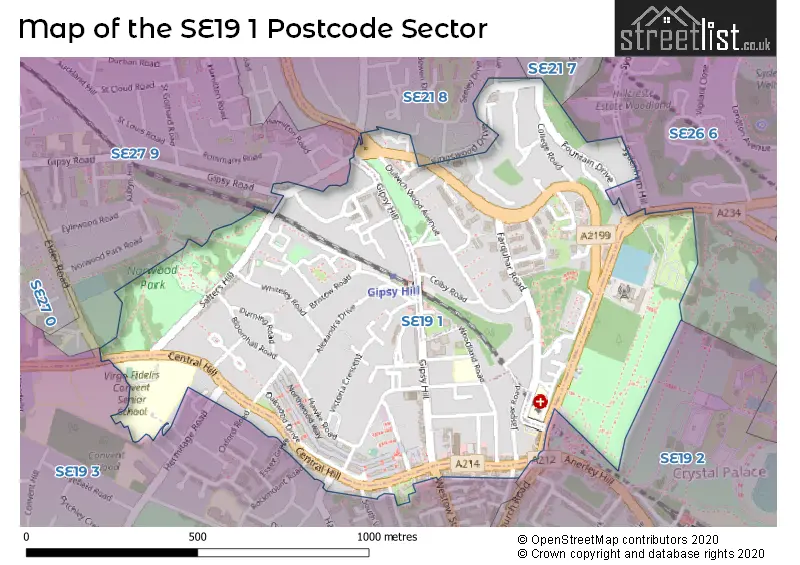
The SE19 1 Postcode shares a border with SE19 2 (UPPER NORWOOD , ANERLEY , PENGE ), SE21 8 (LONDON ), SE27 9 (LONDON ), SE19 3 (UPPER NORWOOD , LONDON ), SE21 7 (LONDON ) and SE26 6 (LONDON , SYDENHAM ).
The sector is within the post town of LONDON.
SE19 1 is a postcode sector within the SE19 postcode district which is within the SE South Eastern London postcode area.
The Royal Mail delivery office for the SE19 1 postal sector is the Norwood Sdelivery Office.
The area of the SE19 1 postcode sector is 0.51 square miles which is 1.31 square kilometres or 324.21 square acres.


Map of the SE19 1 Postcode Sector
Explore the SE19 1 postcode sector by using our free interactive map.
| S | E | 1 | 9 | - | 1 | X | X |
| S | E | 1 | 9 | Space | 1 | Letter | Letter |
Official List of Streets
Lambeth (52 Streets)
Southwark (24 Streets)
Croydon (3 Streets)
Bromley (1 Streets)
Unofficial Streets or Alternative Spellings
Lewisham
SYDENHAM HILL WESTWOOD HILLSouthwark
LYALL AVENUE OAKFIELD GARDENS ROCK HILL WAVEL PLACEBromley
ANERLEY HILLLambeth
ELDER ROAD GIPSY ROAD GRAZELEY COURT ROMMANY ROAD SOUTH CROXTED ROADCroydon
CROWN DALE ESSEX GROVE GATESTONE ROAD HAROLD ROAD HERMITAGE ROAD OXFORD ROAD ROCKMOUNT ROAD SOUTH VALE VERMONT ROAD WESTOW STREET ALBERT YARD BELL MEADOW BLUEBELL CLOSE BURMA TERRACE CITY PROSPECT CRYSTAL COURT CRYSTAL PALACE HIGH LEVEL STATION SUBWAY FORBES COURT HIGHLANDS COURT HITHERWOOD COURT HOGARTH COURT HUNTERS MEADOW JASPER PASSAGE LAMBETH PROSPECT LONDON PROSPECT MELBOURNE YARD OLD COPLE LANE PAXTON GREEN ROUNDABOUT PRINCESS COTTAGES ROMMANY PROSPECT SAINT AUBYNS ROAD ST AUBYNS ROAD UPPER TERRACE VALLEY PROSPECT WESTWOOD HILL (CYCLEWAY) WICKERS OAKESchools and Places of Education Within the SE19 1 Postcode Sector
Paxton Primary School
Community school
Woodland Road, London, , SE19 1PA
Head: Mr Jeff Muhammad
Ofsted Rating: Requires improvement
Inspection: 2022-06-08 (730 days ago)
Website: Visit Paxton Primary School Website
Phone: 02086702935
Number of Pupils: 501
House Prices in the SE19 1 Postcode Sector
| Type of Property | 2018 Average | 2018 Sales | 2017 Average | 2017 Sales | 2016 Average | 2016 Sales | 2015 Average | 2015 Sales |
|---|---|---|---|---|---|---|---|---|
| Detached | £1,025,500 | 4 | £1,600,000 | 1 | £1,118,250 | 2 | £1,628,333 | 3 |
| Semi-Detached | £704,910 | 5 | £608,600 | 5 | £513,380 | 10 | £625,100 | 14 |
| Terraced | £640,058 | 16 | £666,419 | 22 | £701,925 | 20 | £569,267 | 30 |
| Flats | £397,701 | 84 | £414,802 | 113 | £378,822 | 116 | £351,803 | 133 |
Important Postcodes SE19 1 in the Postcode Sector
SE19 1AA is the postcode for Central Hill Day Centre, Lunham Road
SE19 1DT is the postcode for Gipsy Hill Police Station, 66 Central Hill, and Metropolitan Police, Gipsy Hill Police Station, 66 Central Hill
SE19 1PA is the postcode for Paxton Primary School, Woodland Road
SE19 1RS is the postcode for Virgo Fidelis Convent Senior School, 147 Central Hill
SE19 1SZ is the postcode for Bowley Close Centre, Bowley Close, BOWLEY CLOSE CENTRE, BOWLEY CLOSE, LONDON, and Rehabilitation Centre, Bowley Close
SE19 1TJ is the postcode for London Borough of Lambeth, Upper Norwood Joint Library, Westow Hill
| The SE19 1 Sector is within these Local Authorities |
|
|---|---|
| The SE19 1 Sector is within these Counties |
|
| The SE19 1 Sector is within these Water Company Areas |
|