The ST18 9 postcode sector is within the county of Staffordshire.
Did you know? According to the 2021 Census, the ST18 9 postcode sector is home to a bustling 5,960 residents!
Given that each sector allows for 400 unique postcode combinations. Letters C, I, K, M, O and V are not allowed in the last two letters of a postcode. With 220 postcodes already in use, this leaves 180 units available.
The largest settlement in the ST18 9 postal code is Haughton followed by Derrington, and Seighford.
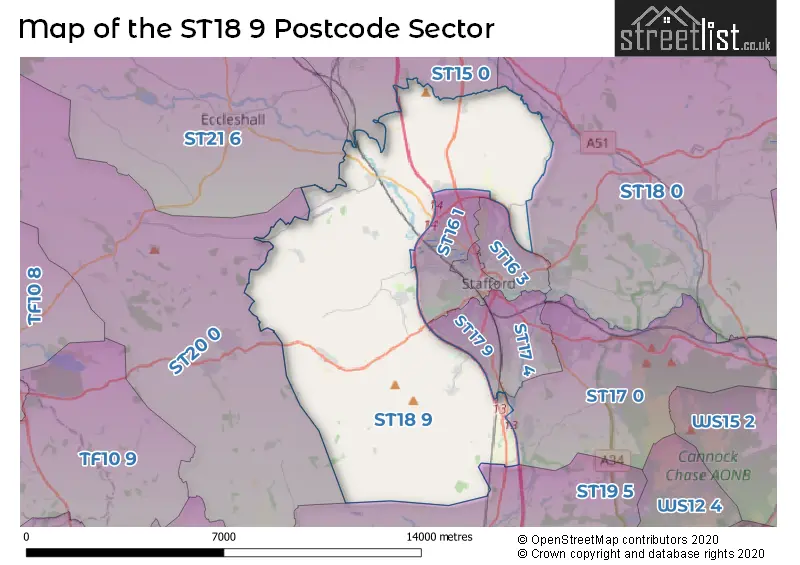
The ST18 9 Postcode shares a border with ST19 5 (Penkridge, Gailey), ST15 0 (STONE, Yarnfield, Swynnerton), ST16 1 (STAFFORD), ST16 3 (STAFFORD, Tollgate Industrial Estate), ST17 0 (STAFFORD, Brocton, Acton Trussell), ST17 4 (STAFFORD), ST17 9 (STAFFORD), ST18 0 (STAFFORD, Great Haywood, Hixon), ST20 0 (Gnosall, Church Eaton, Woodseaves) and ST21 6 (Eccleshall, Cotes Heath, Standon).
The sector is within the post town of STAFFORD.
ST18 9 is a postcode sector within the ST18 postcode district which is within the ST Stoke-on-Trent postcode area.
The Royal Mail delivery office for the ST18 9 postal sector is the Stafford Delivery Office.
The area of the ST18 9 postcode sector is 34.74 square miles which is 89.97 square kilometres or 22,232.57 square acres.
The ST18 9 postcode sector is crossed by the A449 Major A road.
The ST18 9 postcode sector is crossed by the A34 Major A road.
The ST18 9 postcode sector is crossed by the M6 motorway.
Waterways within the ST18 9 postcode sector include the River Penk.

Map of the ST18 9 Postcode Sector
Explore the ST18 9 postcode sector by using our free interactive map.
| S | T | 1 | 8 | - | 9 | X | X |
| S | T | 1 | 8 | Space | 9 | Letter | Letter |
Official List of Streets
Ranton (10 Streets)
Acton Gate (1 Streets)
Haughton (37 Streets)
Bradley (17 Streets)
STAFFORD (7 Streets)
Coppenhall (8 Streets)
Derrington (18 Streets)
Hyde Lea (10 Streets)
Seighford (10 Streets)
Great Bridgeford (14 Streets)
Marston (4 Streets)
Dunston (6 Streets)
Little Bridgeford (2 Streets)
Coton Clanford (2 Streets)
Whitgreave (2 Streets)
Dunston Heath (3 Streets)
Enson (1 Streets)
Hopton (1 Streets)
Sandon Bank (1 Streets)
Unofficial Streets or Alternative Spellings
Sandon Bank
SALT LANE ASH FLATS LANE ASTON BANK ASTON HILL BADGERS CROFT BANK HOUSE FARM BIGWOOD LANE BILLINGTON BANK BRAMHALL CLOSE BURTON BANK LANE BUTTER BANK BUTTERBANK LANE CHAPEL LANE CLANFORD LANE COTON LANE CRESWELL INTERCHANGE DUNSTON INTERCHANGE EDGE ROAD ENSON LANE FIRTREE CLOSE FIVE LANES ENDS FURLONG LANE GORSTY LANE GREAT BRIDGEFORD OLD YARD HARRY KERR DRIVE JOLT LANE LOVE LANE MARCH LANE MOOR LANE MOSSPIT NEWPORT TO STAFFORD GREENWAY OAK LANE OLDFORD LANE PATON DRIVE RAILWAY COTTAGES RANTON ROAD SEIGHFORD ROAD SHIPPY LANE SHOOTINGPIT LANE STAPLES CLOSE STOCKING LANE STOCKING-GATE LANE STONEY LANE SUMMERHILL LANE TOFT LANE VALLEY FARM ROAD WELLS LANE WILLIAM BAGNALL DRIVE WOLVERHAMPTON ROADHopton
WITHIN LANESTAFFORD
BEACONSIDE CASTLE BANK HARROW PLACE PORTAL ROADRedhill Business Park
AMISON CLOSETollgate Industrial Estate
TOLLGATE DRIVEActon Trussell
MILL LANEPenkridge
LEVEDALE ROADDerrington
CASTLE VIEW ESTATESTONE
PIREHILL LANESalt
SALT BANKSBroad Heath
BRIDLE LANEKnightley
STAFFORD ROADSchools and Places of Education Within the ST18 9 Postcode Sector
All Saints CofE (VC) Primary School
Voluntary controlled school
Bourne Avenue, Stafford, Staffordshire, ST18 9JU
Head: Ms Charlotte Ashton
Ofsted Rating: Requires improvement
Inspection: 2022-03-23 (809 days ago)
Website: Visit All Saints CofE (VC) Primary School Website
Phone: 01785282228
Number of Pupils: 59
Cooper Perry Primary School
Community school
Seighford, Stafford, Staffordshire, ST18 9PQ
Head: Mrs Emily Proffitt
Ofsted Rating: Good
Inspection: 2021-12-08 (914 days ago)
Website: Visit Cooper Perry Primary School Website
Phone: 01785282210
Number of Pupils: 206
Haughton St Giles CofE Primary Academy
Academy converter
Prince Avenue, Stafford, Staffordshire, ST18 9ET
Head: Miss Victoria Hulme
Ofsted Rating: Good
Inspection: 2023-03-14 (453 days ago)
Website: Visit Haughton St Giles CofE Primary Academy Website
Phone: 01785780511
Number of Pupils: 104
Longridge School
Other independent special school
Levedale Road, , , ST18 9AL
Head: Mrs Carol Harvey
Ofsted Rating: Inadequate
Inspection: 2022-11-17 (570 days ago)
Website: Visit Longridge School Website
Phone: 01785556710
Number of Pupils: 6
The Haven School
Other independent special school
Cabins 24, 25 and 26, Staffordshire, Staffordshire, ST18 9AB
Head: Mrs Zoie Stevenson
Ofsted Rating: Good
Inspection: 2020-03-12 (1550 days ago)
Website: Visit The Haven School Website
Phone: 01785214172
Number of Pupils: 38
House Prices in the ST18 9 Postcode Sector
| Type of Property | 2018 Average | 2018 Sales | 2017 Average | 2017 Sales | 2016 Average | 2016 Sales | 2015 Average | 2015 Sales |
|---|---|---|---|---|---|---|---|---|
| Detached | £354,718 | 74 | £306,124 | 77 | £361,404 | 54 | £294,379 | 62 |
| Semi-Detached | £197,870 | 23 | £195,881 | 21 | £190,430 | 25 | £188,817 | 21 |
| Terraced | £309,619 | 8 | £238,389 | 9 | £236,914 | 7 | £232,632 | 11 |
| Flats | £86,250 | 2 | £88,500 | 2 | £89,000 | 1 | £89,750 | 2 |
Important Postcodes ST18 9 in the Postcode Sector
ST18 9AB is the postcode for Barn 1, Dunston Business Village
ST18 9AG is the postcode for St Leonards Church Of England Primary School, School Lane
ST18 9PQ is the postcode for COOPER PERRY PRIMARY SCHOOL, MAIN ROAD, SEIGHFORD, and Cooper Perry Cp School, Seighford
| The ST18 9 Sector is within these Local Authorities |
|
|---|---|
| The ST18 9 Sector is within these Counties |
|
| The ST18 9 Sector is within these Water Company Areas |
|