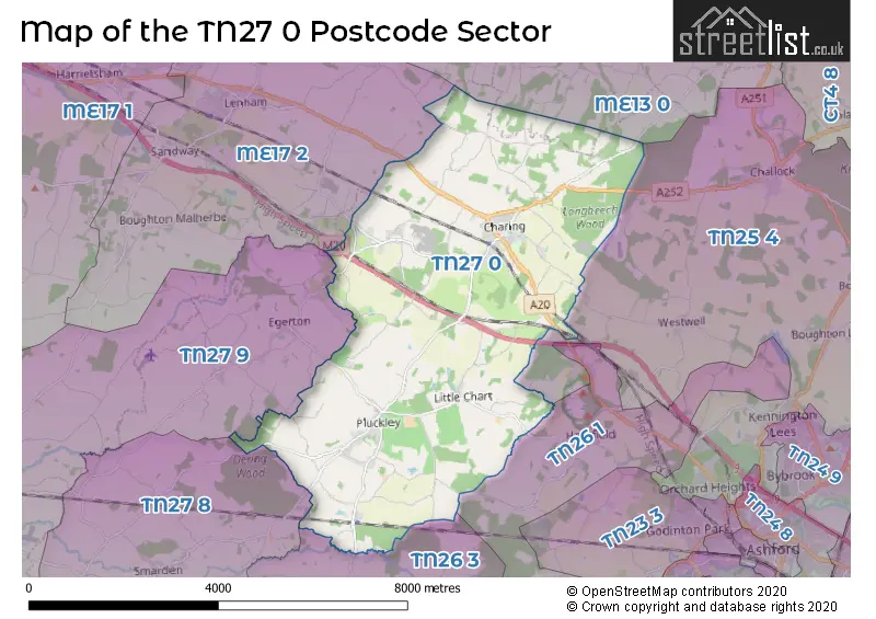
The TN27 0 postcode sector is within the county of Kent.
Did you know? According to the 2021 Census, the TN27 0 postcode sector is home to a bustling 4,541 residents!
Given that each sector allows for 400 unique postcode combinations. Letters C, I, K, M, O and V are not allowed in the last two letters of a postcode. With 200 postcodes already in use, this leaves 200 units available.
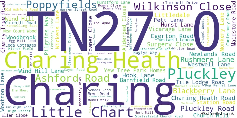
The largest settlement in the TN27 0 postal code is Charing followed by Pluckley, and Charing Heath.
The TN27 0 Postcode shares a border with TN25 4 (ASHFORD, Challock, Kennington), TN26 1 (Shadoxhurst, Hothfield, Great Chart), TN26 3 (Bethersden, Woodchurch, High Halden), ME13 0 (Oare, Ospringe, Eastling), ME17 2 (Lenham, Lenham Heath, Grafty Green), TN27 8 (Biddenden, Smarden) and TN27 9 (Headcorn, Egerton).
The sector is within the post town of ASHFORD.
TN27 0 is a postcode sector within the TN27 postcode district which is within the TN Tonbridge postcode area.
The Royal Mail delivery office for the TN27 0 postal sector is the Ashford (tn) Delivery Office and Charing Scale Payment Delivery Office.
The area of the TN27 0 postcode sector is 16.48 square miles which is 42.68 square kilometres or 10,546.61 square acres.
The TN27 0 postcode sector is crossed by the M20 motorway.
Waterways within the TN27 0 postcode sector include the Upper Great Stour.

Map of the TN27 0 Postcode Sector
Explore the TN27 0 postcode sector by using our free interactive map.
| T | N | 2 | 7 | - | 0 | X | X |
| T | N | 2 | 7 | Space | 0 | Letter | Letter |
Official List of Streets
Charing (57 Streets)
Charing Heath (9 Streets)
Little Chart (8 Streets)
Pluckley (18 Streets)
Unofficial Streets or Alternative Spellings
Challock
CANTERBURY ROADHothfield
RAM LANE WEST STREET AW4 CLEARMOUNT PARK ELVEY LANE FORGE HILL GREENHILL LANE HUNGER HATCH LANE LONGBEECH PARK MALMAINS ROAD NORTH DOWNS WAY/PILGRIMS WAY NORTHERN BY-PASS OTIUM LAKE PIVINGTON LANE ROSE FARM LANE SMARDEN BELL ROAD STONESTILE FARM ROAD THE APPLE TREES THE GLEBE THE HIGH STREET THORN ESTATE TOLL LANE WARREN STREET WATERDITCH ROADBethersden
PLUCKLEY ROAD SPARROW HATCH LANECharing
DOG KENNEL LANEThrowley
ALMSHOUSE ROAD CHURCH ROADEgerton
COACH ROAD FIELD MILL ROAD MUNDY BOIS ROADSmarden
PLUCKLEY ROADWeather Forecast for TN27 0
Press Button to Show Forecast for Bethersden
| Time Period | Icon | Description | Temperature | Rain Probability | Wind |
|---|---|---|---|---|---|
| 18:00 to 21:00 | Cloudy | 15.0°C (feels like 14.0°C) | 3.00% | NNE 7 mph | |
| 21:00 to 00:00 | Cloudy | 12.0°C (feels like 11.0°C) | 4.00% | NNW 7 mph |
Press Button to Show Forecast for Bethersden
| Time Period | Icon | Description | Temperature | Rain Probability | Wind |
|---|---|---|---|---|---|
| 00:00 to 03:00 | Cloudy | 12.0°C (feels like 10.0°C) | 12.00% | N 11 mph | |
| 03:00 to 06:00 | Light rain shower (night) | 11.0°C (feels like 10.0°C) | 29.00% | NE 7 mph | |
| 06:00 to 09:00 | Cloudy | 12.0°C (feels like 11.0°C) | 8.00% | N 7 mph | |
| 09:00 to 12:00 | Overcast | 14.0°C (feels like 14.0°C) | 47.00% | SW 4 mph | |
| 12:00 to 15:00 | Overcast | 16.0°C (feels like 15.0°C) | 10.00% | SW 9 mph | |
| 15:00 to 18:00 | Overcast | 17.0°C (feels like 15.0°C) | 10.00% | WSW 9 mph | |
| 18:00 to 21:00 | Overcast | 15.0°C (feels like 13.0°C) | 13.00% | WSW 9 mph | |
| 21:00 to 00:00 | Overcast | 12.0°C (feels like 10.0°C) | 13.00% | WSW 11 mph |
Press Button to Show Forecast for Bethersden
| Time Period | Icon | Description | Temperature | Rain Probability | Wind |
|---|---|---|---|---|---|
| 00:00 to 03:00 | Overcast | 11.0°C (feels like 8.0°C) | 17.00% | WSW 11 mph | |
| 03:00 to 06:00 | Overcast | 10.0°C (feels like 7.0°C) | 15.00% | WSW 11 mph | |
| 06:00 to 09:00 | Cloudy | 10.0°C (feels like 7.0°C) | 17.00% | WSW 13 mph | |
| 09:00 to 12:00 | Cloudy | 11.0°C (feels like 8.0°C) | 17.00% | WSW 16 mph | |
| 12:00 to 15:00 | Cloudy | 13.0°C (feels like 10.0°C) | 15.00% | WSW 16 mph | |
| 15:00 to 18:00 | Cloudy | 13.0°C (feels like 11.0°C) | 11.00% | WSW 16 mph | |
| 18:00 to 21:00 | Sunny day | 13.0°C (feels like 10.0°C) | 4.00% | SW 11 mph | |
| 21:00 to 00:00 | Clear night | 9.0°C (feels like 7.0°C) | 2.00% | SW 9 mph |
Press Button to Show Forecast for Bethersden
| Time Period | Icon | Description | Temperature | Rain Probability | Wind |
|---|---|---|---|---|---|
| 00:00 to 03:00 | Clear night | 8.0°C (feels like 6.0°C) | 1.00% | SW 7 mph | |
| 03:00 to 06:00 | Clear night | 7.0°C (feels like 5.0°C) | 1.00% | SSW 7 mph | |
| 06:00 to 09:00 | Partly cloudy (day) | 9.0°C (feels like 7.0°C) | 3.00% | S 7 mph | |
| 09:00 to 12:00 | Partly cloudy (day) | 13.0°C (feels like 11.0°C) | 7.00% | S 9 mph | |
| 12:00 to 15:00 | Cloudy | 15.0°C (feels like 13.0°C) | 11.00% | S 9 mph | |
| 15:00 to 18:00 | Cloudy | 15.0°C (feels like 13.0°C) | 15.00% | S 9 mph | |
| 18:00 to 21:00 | Cloudy | 13.0°C (feels like 12.0°C) | 14.00% | SSE 7 mph | |
| 21:00 to 00:00 | Cloudy | 10.0°C (feels like 9.0°C) | 14.00% | SE 7 mph |
Press Button to Show Forecast for Bethersden
| Time Period | Icon | Description | Temperature | Rain Probability | Wind |
|---|---|---|---|---|---|
| 00:00 to 03:00 | Cloudy | 9.0°C (feels like 8.0°C) | 14.00% | S 7 mph | |
| 03:00 to 06:00 | Partly cloudy (night) | 8.0°C (feels like 7.0°C) | 12.00% | S 7 mph | |
| 06:00 to 09:00 | Cloudy | 10.0°C (feels like 8.0°C) | 13.00% | S 7 mph | |
| 09:00 to 12:00 | Cloudy | 13.0°C (feels like 12.0°C) | 15.00% | S 9 mph | |
| 12:00 to 15:00 | Light rain | 14.0°C (feels like 12.0°C) | 49.00% | SSW 9 mph | |
| 15:00 to 18:00 | Light rain shower (day) | 14.0°C (feels like 13.0°C) | 36.00% | SW 9 mph | |
| 18:00 to 21:00 | Cloudy | 13.0°C (feels like 12.0°C) | 13.00% | SSW 7 mph | |
| 21:00 to 00:00 | Cloudy | 10.0°C (feels like 10.0°C) | 9.00% | S 4 mph |
Schools and Places of Education Within the TN27 0 Postcode Sector
Charing Church of England Primary School
Academy converter
School Road, Ashford, Kent, TN27 0JN
Head: Mr Thomas Bird
Ofsted Rating: Good
Inspection: 2021-10-20 (924 days ago)
Website: Visit Charing Church of England Primary School Website
Phone: 01233712277
Number of Pupils: 165
Heath Farm School
Other independent special school
Egerton Road, Ashford, Kent, TN27 0AX
Head: Mr Jason Pearn
Ofsted Rating: Good
Inspection: 2020-03-05 (1518 days ago)
Website: Visit Heath Farm School Website
Phone: 01233712030
Number of Pupils: 105
Pluckley Church of England Primary School
Academy converter
The Street, Ashford, Kent, TN27 0QS
Head: Mrs Lorraine Smith
Ofsted Rating: Good
Inspection: 2019-06-06 (1791 days ago)
Website: Visit Pluckley Church of England Primary School Website
Phone: 01233840422
Number of Pupils: 96
House Prices in the TN27 0 Postcode Sector
| Type of Property | 2018 Average | 2018 Sales | 2017 Average | 2017 Sales | 2016 Average | 2016 Sales | 2015 Average | 2015 Sales |
|---|---|---|---|---|---|---|---|---|
| Detached | £642,027 | 29 | £599,075 | 35 | £595,150 | 46 | £550,666 | 39 |
| Semi-Detached | £346,291 | 12 | £369,557 | 21 | £332,079 | 19 | £325,797 | 20 |
| Terraced | £287,321 | 7 | £364,889 | 9 | £298,500 | 7 | £290,500 | 13 |
| Flats | £152,498 | 3 | £126,750 | 2 | £143,333 | 3 | £139,600 | 5 |
Important Postcodes TN27 0 in the Postcode Sector
TN27 0AW is the postcode for Charing Surgery, 1 Surgery Close
TN27 0JN is the postcode for MAIN OFFICE, Charing C of E School, School Road, and MAIN SCHOOL, Charing C of E School, School Road
TN27 0QS is the postcode for 3 CLASSROOM BLOCK, Pluckley C of E Primary School, The Street
| The TN27 0 Sector is within these Local Authorities |
|
|---|---|
| The TN27 0 Sector is within these Counties |
|
| The TN27 0 Sector is within these Water Company Areas |
|