The AB15 postcode district is a postal district located in the AB Aberdeen postcode area with a population of 35,627 residents according to the 2011 Scotland Census.
The area of the AB15 postcode district is 18.39 square miles which is 47.62 square kilometres or 11,766.74 acres.
Currently, the AB15 district has about 1067 postcode units spread across 6 geographic postcode sectors.
Given that each sector allows for 400 unique postcode combinations, the district has a capacity of 2,400 postcodes. With 1067 postcodes already in use, this leaves 1333 units available.
The largest settlement in the AB15 postal code is ABERDEEN followed by Cults, and Kingswells.
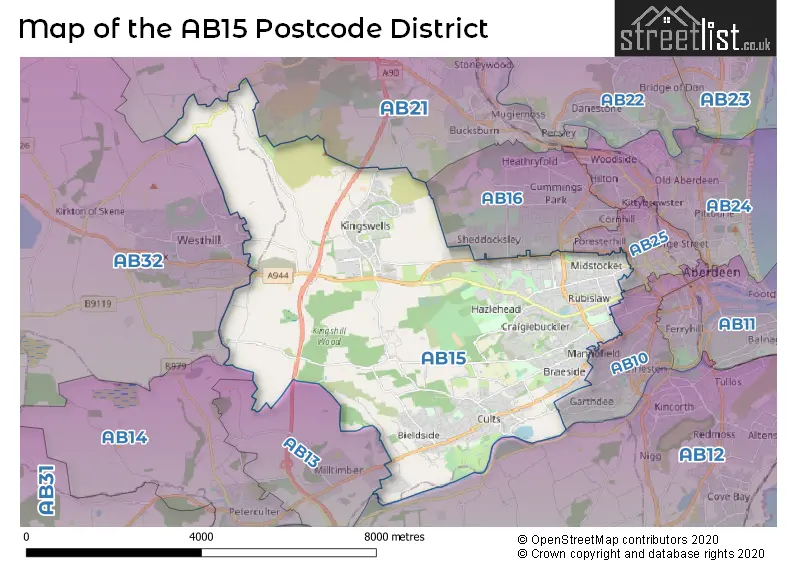
The AB15 Postcode shares a border with AB10 (ABERDEEN), AB12 (ABERDEEN, Portlethen, Cove), AB13 (MILLTIMBER), AB16 (ABERDEEN), AB21 (Bucksburn, Dyce, Newmachar), AB25 (ABERDEEN), AB14 (PETERCULTER) and AB32 (WESTHILL, Elrick, Skene).
The primary settlement in the AB15 postcode district is Aberdeen, which is located in the City of Aberdeen. Other significant settlements in the district include Bieldside, Cults, Blacktop, Craigiebuckler, Hazlehead, and Kingswells. Aberdeen is also the most significant post town in the district.
For the district AB15, we have data on 6 postcode sectors. Here's a breakdown: The sector AB15 4, covers Aberdeen in City of Aberdeen. The sector AB15 5, covers Aberdeen in City of Aberdeen. The sector AB15 6, covers Aberdeen in City of Aberdeen. The sector AB15 7, covers Aberdeen in City of Aberdeen. The sector AB15 8, covers Aberdeen and Kingswells in City of Aberdeen. The sector AB15 9, covers Cults and Bieldside in City of Aberdeen.


Map of the AB15 Postcode District
Explore the AB15 postcode district by using our free interactive map.
When it comes to local government, postal geography often disregards political borders. However, for a breakdown in the AB15 District: the district mostly encompasses the Aberdeen City (1097 postcodes), and finally, the Aberdeenshire area (6 postcodes).
Where is the AB15 Postcode District?
The AB15 postcode district is located in ABERDEEN. This district is surrounded by various nearby towns. To the South West, there is MILLTIMBER, which is approximately 2.15 miles away. To the East, GLASGOW is located at a distance of about 3.08 miles. Towards the West, you will find WESTHILL, which is approximately 5.05 miles away. Further South, there is STONEHAVEN at a distance of around 12.47 miles. Moving towards the North West, you will come across INVERURIE, which is approximately 14.25 miles away. Finally, to the North, there is ELLON, located at a distance of about 17.82 miles. Additionally, the distance from this postcode district to London's center is approximately 398.52 miles.
The district is within the post town of ABERDEEN.
The sector has postcodes within the nation of Scotland.
The AB15 Postcode District is in the Aberdeen City and Aberdeenshire region of North Eastern Scotland within the Scotland.
Weather Forecast for AB15
Press Button to Show Forecast for Westhill
| Time Period | Icon | Description | Temperature | Rain Probability | Wind |
|---|---|---|---|---|---|
| 12:00 to 15:00 | Cloudy | 14.0°C (feels like 12.0°C) | 8.00% | SE 9 mph | |
| 15:00 to 18:00 | Cloudy | 13.0°C (feels like 12.0°C) | 15.00% | ESE 9 mph | |
| 18:00 to 21:00 | Cloudy | 12.0°C (feels like 10.0°C) | 7.00% | ESE 9 mph | |
| 21:00 to 00:00 | Cloudy | 11.0°C (feels like 9.0°C) | 6.00% | ESE 9 mph |
Press Button to Show Forecast for Westhill
| Time Period | Icon | Description | Temperature | Rain Probability | Wind |
|---|---|---|---|---|---|
| 00:00 to 03:00 | Cloudy | 10.0°C (feels like 9.0°C) | 5.00% | ESE 4 mph | |
| 03:00 to 06:00 | Partly cloudy (night) | 10.0°C (feels like 10.0°C) | 2.00% | ESE 4 mph | |
| 06:00 to 09:00 | Partly cloudy (day) | 11.0°C (feels like 11.0°C) | 3.00% | SE 4 mph | |
| 09:00 to 12:00 | Partly cloudy (day) | 15.0°C (feels like 14.0°C) | 1.00% | SE 7 mph | |
| 12:00 to 15:00 | Sunny day | 16.0°C (feels like 15.0°C) | 0.00% | ESE 9 mph | |
| 15:00 to 18:00 | Sunny day | 14.0°C (feels like 13.0°C) | 1.00% | ESE 9 mph | |
| 18:00 to 21:00 | Sunny day | 13.0°C (feels like 11.0°C) | 1.00% | ESE 9 mph | |
| 21:00 to 00:00 | Clear night | 10.0°C (feels like 9.0°C) | 1.00% | ESE 4 mph |
Press Button to Show Forecast for Westhill
| Time Period | Icon | Description | Temperature | Rain Probability | Wind |
|---|---|---|---|---|---|
| 00:00 to 03:00 | Clear night | 8.0°C (feels like 7.0°C) | 2.00% | ENE 4 mph | |
| 03:00 to 06:00 | Partly cloudy (night) | 7.0°C (feels like 6.0°C) | 5.00% | NE 4 mph | |
| 06:00 to 09:00 | Sunny day | 10.0°C (feels like 10.0°C) | 4.00% | ENE 4 mph | |
| 09:00 to 12:00 | Sunny day | 14.0°C (feels like 13.0°C) | 0.00% | ESE 7 mph | |
| 12:00 to 15:00 | Sunny day | 16.0°C (feels like 14.0°C) | 0.00% | ESE 9 mph | |
| 15:00 to 18:00 | Sunny day | 15.0°C (feels like 13.0°C) | 1.00% | ESE 9 mph | |
| 18:00 to 21:00 | Sunny day | 13.0°C (feels like 12.0°C) | 0.00% | ESE 9 mph | |
| 21:00 to 00:00 | Clear night | 9.0°C (feels like 8.0°C) | 0.00% | E 4 mph |
Press Button to Show Forecast for Westhill
| Time Period | Icon | Description | Temperature | Rain Probability | Wind |
|---|---|---|---|---|---|
| 00:00 to 03:00 | Clear night | 7.0°C (feels like 7.0°C) | 1.00% | NE 4 mph | |
| 03:00 to 06:00 | Clear night | 7.0°C (feels like 6.0°C) | 5.00% | NNW 4 mph | |
| 06:00 to 09:00 | Sunny day | 10.0°C (feels like 10.0°C) | 3.00% | N 4 mph | |
| 09:00 to 12:00 | Sunny day | 14.0°C (feels like 13.0°C) | 3.00% | ENE 7 mph | |
| 12:00 to 15:00 | Partly cloudy (day) | 15.0°C (feels like 14.0°C) | 5.00% | E 9 mph | |
| 15:00 to 18:00 | Sunny day | 15.0°C (feels like 14.0°C) | 4.00% | E 9 mph | |
| 18:00 to 21:00 | Sunny day | 13.0°C (feels like 12.0°C) | 4.00% | E 7 mph | |
| 21:00 to 00:00 | Clear night | 10.0°C (feels like 9.0°C) | 3.00% | E 4 mph |
Press Button to Show Forecast for Westhill
| Time Period | Icon | Description | Temperature | Rain Probability | Wind |
|---|---|---|---|---|---|
| 00:00 to 03:00 | Partly cloudy (night) | 9.0°C (feels like 8.0°C) | 3.00% | N 4 mph | |
| 03:00 to 06:00 | Fog | 8.0°C (feels like 7.0°C) | 16.00% | NNW 4 mph | |
| 06:00 to 09:00 | Mist | 10.0°C (feels like 9.0°C) | 14.00% | NW 4 mph | |
| 09:00 to 12:00 | Partly cloudy (day) | 14.0°C (feels like 13.0°C) | 3.00% | N 7 mph | |
| 12:00 to 15:00 | Cloudy | 15.0°C (feels like 14.0°C) | 5.00% | NNE 7 mph | |
| 15:00 to 18:00 | Sunny day | 16.0°C (feels like 14.0°C) | 2.00% | NNE 9 mph | |
| 18:00 to 21:00 | Sunny day | 13.0°C (feels like 12.0°C) | 2.00% | E 7 mph | |
| 21:00 to 00:00 | Clear night | 10.0°C (feels like 9.0°C) | 1.00% | E 4 mph |
| Postcode Sector | Delivery Office |
|---|---|
| AB15 4 | Mastrick Delivery Office |
| AB15 5 | Mastrick Delivery Office |
| AB15 6 | Mastrick Delivery Office |
| AB15 7 | Mastrick Delivery Office |
| AB15 8 | Mastrick Delivery Office |
| AB15 9 | Mastrick Delivery Office |
| A | B | 1 | 5 | - | X | X | X |
| A | B | 1 | 5 | Space | Numeric | Letter | Letter |
Current Monthly Rental Prices
| # Bedrooms | Min Price | Max Price | Avg Price |
|---|---|---|---|
| 2 | £650 | £1,600 | £949 |
| 3 | £850 | £1,800 | £1,450 |
| 4 | £1,400 | £2,500 | £1,872 |
| 5 | £1,350 | £3,500 | £2,375 |
| 6 | £1,800 | £3,000 | £2,400 |
Current House Prices
| # Bedrooms | Min Price | Max Price | Avg Price |
|---|---|---|---|
| £750,000 | £10,000,000 | £3,337,500 | |
| 4 | £524,950 | £550,000 | £534,982 |
| 5 | £525,000 | £1,400,000 | £740,496 |
| 6 | £550,000 | £1,450,000 | £1,000,000 |
| 7 | £2,500,000 | £2,500,000 | £2,500,000 |
| 8 | £1,975,000 | £1,975,000 | £1,975,000 |
| 9 | £2,500,000 | £2,500,000 | £2,500,000 |
| 11 | £7,500,000 | £7,500,000 | £7,500,000 |
Estate Agents who Operate in the AB15 District
| Logo | Name | Brand Name | Address | Contact Number | Total Properties |
|---|---|---|---|---|---|
 | Aberdeen | Stonehouse Lettings | Neo House, Riverside Drive, Aberdeen, AB11 7DG | 020 3840 3898 | 11 |
 | Aberdeen & Angus | Savills | 37 Albyn Place Aberdeen AB10 1YN | 01224 007498 | 9 |
 | Aberdeen | Margaret Duffus Leasing | 52 Bon Accord Street Aberdeen AB11 6EL | 020 3909 9671 | 8 |
 | Aberdeen | Aberdeen Property Leasing | 138 - 140 Rosemount Place, Aberdeen, AB25 2YU | 01224 007631 | 7 |
 | covering Aberdeen | Purplebricks | Suite 7 First Floor Cranmore Drive Shirley Solihull B90 4RZ | 024 7542 8812 | 6 |