The AL10 9 postcode sector is within the county of Hertfordshire.
Did you know? According to the 2021 Census, the AL10 9 postcode sector is home to a bustling 17,184 residents!
Given that each sector allows for 400 unique postcode combinations. Letters C, I, K, M, O and V are not allowed in the last two letters of a postcode. With 280 postcodes already in use, this leaves 120 units available.
The AL10 9 postal code covers the settlement of HATFIELD.
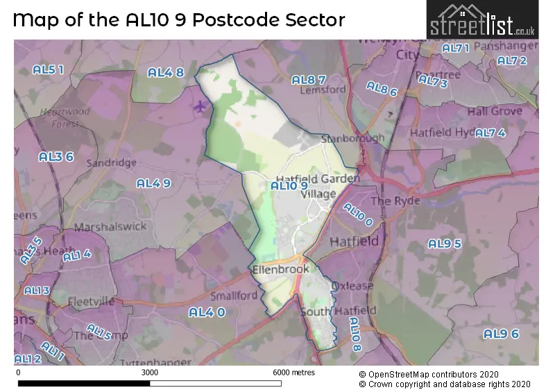
The AL10 9 Postcode shares a border with AL4 0 (ST. ALBANS, Colney Heath, Smallford), AL4 8 (Wheathampstead), AL4 9 (ST. ALBANS, Sandridge), AL10 8 (HATFIELD), AL8 7 (WELWYN GARDEN CITY, Lemsford), AL9 5 (HATFIELD, Essendon, North Mymms) and AL10 0 (HATFIELD).
The sector is within the post town of HATFIELD.
AL10 9 is a postcode sector within the AL10 postcode district which is within the AL St Albans postcode area.
The Royal Mail delivery office for the AL10 9 postal sector is the Hatfield (al) Delivery Office.
The area of the AL10 9 postcode sector is 4.17 square miles which is 10.81 square kilometres or 2,671.39 square acres.
The AL10 9 postcode sector is crossed by the A1001 Major A road.
The AL10 9 postcode sector is crossed by the A1M Major A road.


Map of the AL10 9 Postcode Sector
Explore the AL10 9 postcode sector by using our free interactive map.
| A | L | 1 | 0 | - | 9 | X | X |
| A | L | 1 | 0 | Space | 9 | Letter | Letter |
Official List of Streets
HATFIELD (121 Streets)
Unofficial Streets or Alternative Spellings
HATFIELD
GARDEN AVENUE HASELDINE MEADOWS HIGH VIEW HILL LEY LARK RISE MARYLAND NORTHDOWN ROAD THE DOWNS THE WADES WOODS AVENUE ALBAN WAY ALBATROSS WAY BISHOP SQUARE BULLENS GREEN LANE BUTLER WALK BUTTLER WALK C.P. SNOW WALK CAMPION WAY CAVENDISH WAY COLEMAN GREEN LANE COMET ROUNDABOUT DRAGON MOTH ROAD FOURTH ROUNDABOUT GOLDSMITH WAY HARPSFIELD BROADWAY HATFIELD TUNNEL JETLINER WAY MARY BAILEY WALK OYPSY MOTH AVENUE ROEHYDE INTERCHANGE SYMONDSHYDE LANE THE AIRFIELD ROUNDABOUT TOMS FIELD WATERY LANE WHITEGATE COTTAGESLemsford
GREEN LANESSandridge
HAMMONDS LANESmallford
HATFIELD ROADHATFIELD,
COOPERS GREEN LANEColney Heath
NORTH ORBITAL ROADWeather Forecast for AL10 9
Press Button to Show Forecast for Hatfield (Hertfordshire)
| Time Period | Icon | Description | Temperature | Rain Probability | Wind |
|---|---|---|---|---|---|
| 12:00 to 15:00 | Overcast | 9.0°C (feels like 7.0°C) | 12.00% | NE 9 mph | |
| 15:00 to 18:00 | Cloudy | 11.0°C (feels like 9.0°C) | 45.00% | NNE 9 mph | |
| 18:00 to 21:00 | Cloudy | 10.0°C (feels like 8.0°C) | 57.00% | NE 11 mph | |
| 21:00 to 00:00 | Light rain | 8.0°C (feels like 6.0°C) | 62.00% | NNE 11 mph |
Press Button to Show Forecast for Hatfield (Hertfordshire)
| Time Period | Icon | Description | Temperature | Rain Probability | Wind |
|---|---|---|---|---|---|
| 00:00 to 03:00 | Heavy rain | 8.0°C (feels like 4.0°C) | 84.00% | NNE 11 mph | |
| 03:00 to 06:00 | Heavy rain | 7.0°C (feels like 4.0°C) | 89.00% | NNE 11 mph | |
| 06:00 to 09:00 | Heavy rain | 7.0°C (feels like 5.0°C) | 89.00% | NNE 9 mph | |
| 09:00 to 12:00 | Heavy rain | 8.0°C (feels like 6.0°C) | 80.00% | NNW 9 mph | |
| 12:00 to 15:00 | Light rain | 10.0°C (feels like 7.0°C) | 56.00% | WNW 9 mph | |
| 15:00 to 18:00 | Overcast | 10.0°C (feels like 7.0°C) | 22.00% | W 9 mph | |
| 18:00 to 21:00 | Cloudy | 9.0°C (feels like 8.0°C) | 12.00% | W 7 mph | |
| 21:00 to 00:00 | Partly cloudy (night) | 7.0°C (feels like 6.0°C) | 5.00% | SW 7 mph |
Press Button to Show Forecast for Hatfield (Hertfordshire)
| Time Period | Icon | Description | Temperature | Rain Probability | Wind |
|---|---|---|---|---|---|
| 00:00 to 03:00 | Clear night | 6.0°C (feels like 4.0°C) | 3.00% | SW 7 mph | |
| 03:00 to 06:00 | Clear night | 5.0°C (feels like 3.0°C) | 2.00% | SSW 4 mph | |
| 06:00 to 09:00 | Sunny day | 6.0°C (feels like 4.0°C) | 1.00% | S 7 mph | |
| 09:00 to 12:00 | Partly cloudy (day) | 11.0°C (feels like 9.0°C) | 1.00% | SSW 9 mph | |
| 12:00 to 15:00 | Partly cloudy (day) | 13.0°C (feels like 11.0°C) | 3.00% | S 11 mph | |
| 15:00 to 18:00 | Partly cloudy (day) | 14.0°C (feels like 11.0°C) | 2.00% | S 11 mph | |
| 18:00 to 21:00 | Sunny day | 13.0°C (feels like 10.0°C) | 2.00% | S 9 mph | |
| 21:00 to 00:00 | Clear night | 9.0°C (feels like 7.0°C) | 1.00% | SSE 7 mph |
Press Button to Show Forecast for Hatfield (Hertfordshire)
| Time Period | Icon | Description | Temperature | Rain Probability | Wind |
|---|---|---|---|---|---|
| 00:00 to 03:00 | Clear night | 8.0°C (feels like 6.0°C) | 2.00% | SE 7 mph | |
| 03:00 to 06:00 | Clear night | 7.0°C (feels like 5.0°C) | 3.00% | ESE 7 mph | |
| 06:00 to 09:00 | Partly cloudy (day) | 9.0°C (feels like 7.0°C) | 6.00% | ESE 7 mph | |
| 09:00 to 12:00 | Partly cloudy (day) | 13.0°C (feels like 11.0°C) | 6.00% | SE 9 mph | |
| 12:00 to 15:00 | Partly cloudy (day) | 15.0°C (feels like 13.0°C) | 9.00% | SE 11 mph | |
| 15:00 to 18:00 | Partly cloudy (day) | 15.0°C (feels like 14.0°C) | 10.00% | SE 9 mph | |
| 18:00 to 21:00 | Cloudy | 14.0°C (feels like 13.0°C) | 13.00% | SE 9 mph | |
| 21:00 to 00:00 | Partly cloudy (night) | 12.0°C (feels like 10.0°C) | 11.00% | ESE 7 mph |
Schools and Places of Education Within the AL10 9 Postcode Sector
Green Lanes Primary School
Community school
Green Lanes, Hatfield, Hertfordshire, AL10 9JY
Head: Michele Johnson
Ofsted Rating: Good
Inspection: 2023-05-24 (339 days ago)
Website: Visit Green Lanes Primary School Website
Phone: 01707262556
Number of Pupils: 414
Howe Dell Primary School
Community school
The Runway, Hatfield, Hertfordshire, AL10 9AH
Head: Miss Tracy Prickett
Ofsted Rating: Outstanding
Inspection: 2023-07-12 (290 days ago)
Website: Visit Howe Dell Primary School Website
Phone: 01707263291
Number of Pupils: 454
University of Hertfordshire
Higher education institutions
Hatfield Campus, Hatfield, Hertfordshire, AL10 9AB
Head: Professor Quintin McKellar
Ofsted Rating: Requires improvement
Inspection: 2022-10-07 (568 days ago)
Website: Visit University of Hertfordshire Website
Phone: 01707284000
Number of Pupils: 0
House Prices in the AL10 9 Postcode Sector
| Type of Property | 2018 Average | 2018 Sales | 2017 Average | 2017 Sales | 2016 Average | 2016 Sales | 2015 Average | 2015 Sales |
|---|---|---|---|---|---|---|---|---|
| Detached | £609,912 | 17 | £587,498 | 20 | £508,806 | 26 | £533,120 | 23 |
| Semi-Detached | £468,078 | 32 | £418,166 | 28 | £430,958 | 38 | £342,454 | 39 |
| Terraced | £330,472 | 68 | £347,564 | 62 | £334,204 | 84 | £287,826 | 88 |
| Flats | £224,467 | 48 | £239,721 | 53 | £222,504 | 67 | £204,824 | 67 |
Important Postcodes AL10 9 in the Postcode Sector
AL10 9AB is the postcode for HUTTON, University of Hertfordshire, College Lane, FILM, MUSIC & MEDIA FACILITIES, University of Hertfordshire, College Lane, MAIN BUILDING, University of Hertfordshire, College Lane, HUT Q, University of Hertfordshire, College Lane, NEW SCIENCE BLOCK, University of Hertfordshire, College Lane, INNOVATION CENTRE, University of Hertfordshire, College Lane, WRIGHT EXTENSION, University of Hertfordshire, College Lane, SCIENCE & CHEMISTRY, University of Hertfordshire, College Lane, NEW HUTTON HUB, University of Hertfordshire, College Lane, University of Hertfordshire, College Lane, ART AND DESIGN BUILDING, University of Hertfordshire, College Lane, THE NURSERY, University of Hertfordshire, College Lane, C.P. SNOW, University of Hertfordshire, College Lane, LINDOP BUILDING, University of Hertfordshire, College Lane, AUTOMOTIVE CENTRE, University of Hertfordshire, College Lane, Coales Hall, University of Hertfordshire, WRIGHT BUILDING, University of Hertfordshire, College Lane, C.P. SNOW PSYCHOLOGY, University of Hertfordshire, College Lane, SERVICES BUILDING, University of Hertfordshire, College Lane, MERCER BUILDING, University of Hertfordshire, College Lane, YORKON BUILDING, University of Hertfordshire, College Lane, TODD BUILDING, University of Hertfordshire, College Lane, ELE HOUSE, University of Hertfordshire, College Lane, HEALTH RESEARCH BUILDING, University of Hertfordshire, College Lane, THE KEY, University of Hertfordshire, College Lane, HILLSIDE HOUSE, University of Hertfordshire, College Lane, HIC, University of Hertfordshire, College Lane, STUDENT FORUM, University of Hertfordshire, College Lane, Broad Hall, University of Hertfordshire, Butler/Fern, University of Hertfordshire, THE BARN, University of Hertfordshire, College Lane, JOHN LILL MUSIC CENTRE, University of Hertfordshire, College Lane, LEARNING RESOURCES CENTRE, University of Hertfordshire, College Lane, HUT E, University of Hertfordshire, College Lane, and Chapman Hall, University of Hertfordshire
AL10 9AH is the postcode for Howe Dell School, The Runway, HOWE DELL SCHOOL, THE RUNWAY, HATFIELD, and Howe Dell Primary School, The Runway
AL10 9BE is the postcode for Sandridge, De Havilland Campus, Outdoor Changing Rooms, De Havilland Campus, Sarratt, De Havilland Campus, Lemsford, De Havilland Campus, Shenley, De Havilland Campus, Kimpton, De Havilland Campus, Ashwell, De Havilland Campus, Hadham, De Havilland Campus, Residential Services Office, De Havilland Campus, Mosquito Way, Redbourn, De Havilland Campus, Residential Services Office Building, De Havilland Campus, Mosquito Way, Watton, De Havilland Campus, Welwyn, De Havilland Campus, Outdoor Changing Rooms, De Havilland Campus, Mosquito Way, and Aldenham, De Havilland Campus
AL10 9BS is the postcode for University Bus Ltd, University Bus Garage, Gypsy Moth Avenue
AL10 9EU is the postcode for De Havilland Academic, De Havilland Campus, BLOCK M, De Havilland Academic, De Havilland Campus, Institute of Sports, De Havilland Campus, Mosquito Way, LEARNING RESOURCE CENTRE, De Havilland Academic, De Havilland Campus, De Havilland Sports & Social Club, De Havilland Campus, Mosquito Way, Enterprise Hub, University of Hertfordshire, De Havilland Campus, Mosquito Way, Hertfordshire Sports Village, De Havilland Campus,, Mosquito Way, THE WESTON AUDITORIUM, De Havilland Academic, De Havilland Campus, BLOCK N, De Havilland Academic, De Havilland Campus, M N & R BUILDINGS, De Havilland Academic, De Havilland Campus, Hertfordshire Sports Village, De Havilland Campus, Mosquito Way, REFECTORY, Hertfordshire Sports Village, De Havilland Campus, Mosquito Way, LAW COURT BUILDING, De Havilland Academic, De Havilland Campus, BLOCK R, De Havilland Academic, De Havilland Campus, and LEARNING RESOURCES CENTRE, DE HAVILLAND CAMPUS, MOSQUITO WAY
AL10 9EX is the postcode for Apollo Court, 2 Bishops Square Business Park
AL10 9JY is the postcode for Green Lanes School, Green Lanes
AL10 9NA is the postcode for 3 Bishops Square Business Park
AL10 9NE is the postcode for Titan Court, Bishops Square Business Park, and MacLaurin Building, 4 Bishops Square Business Park
AL10 9SJ is the postcode for Hertfordshire Constabulary, Hatfield Police Station, Comet Way
AL10 9SL is the postcode for Royal Mail, Northern Home Counties Distribution Centre, Frobisher Way, Hatfield Business Park
AL10 9TP is the postcode for University of Hertfordshire, Fielder Centre, Manor Road, and Fielder Centre, Hatfield Avenue
| The AL10 9 Sector is within these Local Authorities |
|
|---|---|
| The AL10 9 Sector is within these Counties |
|
| The AL10 9 Sector is within these Water Company Areas |
|