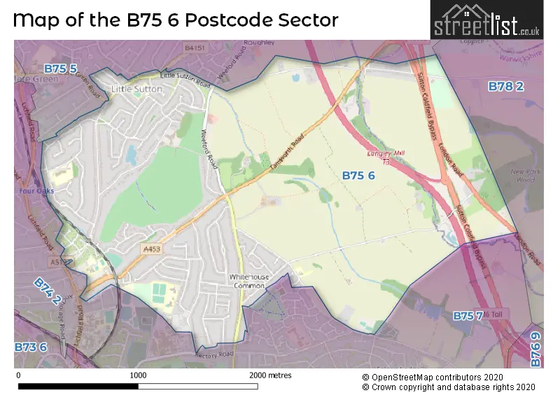
The B75 6 postcode sector lies where the three counties of Warwickshire, West Midlands, and Staffordshire meet.
Did you know? According to the 2021 Census, the B75 6 postcode sector is home to a bustling 8,606 residents!
Given that each sector allows for 400 unique postcode combinations. Letters C, I, K, M, O and V are not allowed in the last two letters of a postcode. With 195 postcodes already in use, this leaves 205 units available.
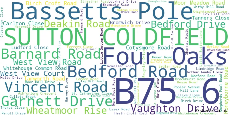
The largest settlements in the B75 6 postal code are SUTTON COLDFIELD and Bassetts Pole.
The B75 6 Postcode shares a border with B74 2 (SUTTON COLDFIELD, Streetly), B75 5 (SUTTON COLDFIELD, Canwell, Bassetts Pole), B75 7 (SUTTON COLDFIELD) and B78 2 (Kingsbury, Middleton, Piccadilly).
The sector is within the post town of SUTTON COLDFIELD.
B75 6 is a postcode sector within the B7 postcode district which is within the B Birmingham postcode area.
The Royal Mail delivery office for the B75 6 postal sector is the unknown.
The area of the B75 6 postcode sector is 2.62 square miles which is 6.80 square kilometres or 1,679.15 square acres.
The B75 6 postcode sector is crossed by the M6 motorway.
The B75 6 postcode sector is crossed by the A38 Major A road.
Waterways within the B75 6 postcode sector include the Collets Brook.

Map of the B75 6 Postcode Sector
Explore the B75 6 postcode sector by using our free interactive map.
| B | 7 | 5 | - | 6 | X | X |
| B | 7 | 5 | Space | 6 | Letter | Letter |
Official List of Streets
SUTTON COLDFIELD (78 Streets)
Bassetts Pole (3 Streets)
Four Oaks (1 Streets)
Unofficial Streets or Alternative Spellings
Middleton
COPPICE LANEBassetts Pole
COLLETS BROOK TAMWORTH ROADSUTTON COLDFIELD
ALLESLEY CLOSE COBURN DRIVE GRANGE LANE LANGLEY MILL CLOSE MARLPIT LANE MERE GREEN ROAD MORDAUNT DRIVE RADBOURN DRIVE RECTORY ROAD SHIFRALL WAY SLADE LANE WHEATMOOR ROAD WILLMOTT ROAD KEEPERS GATE KNIGHTS WOOD CLOSE ST. CATHARINES CLOSE SUTTON COLDFIELD BYPASS SUTTON COURT WHEATMORE ROADCanwell
SLADE ROADWeather Forecast for B75 6
Press Button to Show Forecast for Whitehouse Common
| Time Period | Icon | Description | Temperature | Rain Probability | Wind |
|---|---|---|---|---|---|
| 00:00 to 03:00 | Partly cloudy (night) | 10.0°C (feels like 9.0°C) | 3.00% | SE 7 mph | |
| 03:00 to 06:00 | Cloudy | 9.0°C (feels like 8.0°C) | 5.00% | SE 4 mph | |
| 06:00 to 09:00 | Overcast | 9.0°C (feels like 8.0°C) | 9.00% | ESE 4 mph | |
| 09:00 to 12:00 | Cloudy | 12.0°C (feels like 11.0°C) | 6.00% | ESE 4 mph | |
| 12:00 to 15:00 | Cloudy | 14.0°C (feels like 14.0°C) | 9.00% | ESE 4 mph | |
| 15:00 to 18:00 | Cloudy | 15.0°C (feels like 14.0°C) | 12.00% | E 4 mph | |
| 18:00 to 21:00 | Cloudy | 14.0°C (feels like 13.0°C) | 19.00% | ENE 7 mph | |
| 21:00 to 00:00 | Cloudy | 12.0°C (feels like 11.0°C) | 16.00% | NW 7 mph |
Press Button to Show Forecast for Whitehouse Common
| Time Period | Icon | Description | Temperature | Rain Probability | Wind |
|---|---|---|---|---|---|
| 00:00 to 03:00 | Light rain | 11.0°C (feels like 10.0°C) | 42.00% | NW 9 mph | |
| 03:00 to 06:00 | Overcast | 10.0°C (feels like 8.0°C) | 17.00% | NNW 9 mph | |
| 06:00 to 09:00 | Cloudy | 10.0°C (feels like 8.0°C) | 12.00% | N 9 mph | |
| 09:00 to 12:00 | Cloudy | 12.0°C (feels like 10.0°C) | 12.00% | N 9 mph | |
| 12:00 to 15:00 | Cloudy | 15.0°C (feels like 13.0°C) | 9.00% | N 9 mph | |
| 15:00 to 18:00 | Cloudy | 17.0°C (feels like 15.0°C) | 8.00% | N 11 mph | |
| 18:00 to 21:00 | Partly cloudy (day) | 15.0°C (feels like 14.0°C) | 5.00% | N 9 mph | |
| 21:00 to 00:00 | Cloudy | 12.0°C (feels like 11.0°C) | 5.00% | N 9 mph |
Press Button to Show Forecast for Whitehouse Common
| Time Period | Icon | Description | Temperature | Rain Probability | Wind |
|---|---|---|---|---|---|
| 00:00 to 03:00 | Cloudy | 10.0°C (feels like 9.0°C) | 7.00% | N 9 mph | |
| 03:00 to 06:00 | Overcast | 10.0°C (feels like 8.0°C) | 12.00% | N 7 mph | |
| 06:00 to 09:00 | Overcast | 10.0°C (feels like 8.0°C) | 15.00% | NNW 7 mph | |
| 09:00 to 12:00 | Overcast | 12.0°C (feels like 11.0°C) | 12.00% | N 7 mph | |
| 12:00 to 15:00 | Light rain shower (day) | 15.0°C (feels like 13.0°C) | 29.00% | N 7 mph | |
| 15:00 to 18:00 | Overcast | 16.0°C (feels like 15.0°C) | 17.00% | N 9 mph | |
| 18:00 to 21:00 | Partly cloudy (day) | 16.0°C (feels like 14.0°C) | 9.00% | N 9 mph | |
| 21:00 to 00:00 | Clear night | 13.0°C (feels like 12.0°C) | 15.00% | NNE 9 mph |
Schools and Places of Education Within the B75 6 Postcode Sector
Coppice Primary School
Foundation school
Trinity Road, Sutton Coldfield, West Midlands, B75 6TJ
Head: Mrs Selina Lees
Ofsted Rating: Good
Inspection: 2019-04-04 (1854 days ago)
Website: Visit Coppice Primary School Website
Phone: 01214647022
Number of Pupils: 414
Langley School
Foundation special school
Trinity Road, Sutton Coldfield, West Midlands, B75 6TJ
Head: Mrs Antoinette McCarroll
Ofsted Rating: Good
Inspection: 2019-05-09 (1819 days ago)
Website: Visit Langley School Website
Phone: 01216752929
Number of Pupils: 103
Moor Hall Primary School
Foundation school
Rowallan Road, Sutton Coldfield, West Midlands, B75 6RE
Head: Mr Andrew John Steggall
Ofsted Rating: Outstanding
Inspection: 2014-01-24 (3750 days ago)
Website: Visit Moor Hall Primary School Website
Phone: 01216753966
Number of Pupils: 368
St Joseph's Catholic Primary School
Academy converter
Little Sutton Lane, Sutton Coldfield, West Midlands, B75 6PB
Head: Mr Gerry O'Hara
Ofsted Rating: Good
Inspection: 2023-10-25 (189 days ago)
Website: Visit St Joseph's Catholic Primary School Website
Phone: 01213546270
Number of Pupils: 412
Whitehouse Common Primary School
Foundation school
Cotysmore Road, Sutton Coldfield, West Midlands, B75 6BL
Head: Mrs Fiona Milward
Ofsted Rating: Good
Inspection: 2023-06-14 (322 days ago)
Website: Visit Whitehouse Common Primary School Website
Phone: 01214641918
Number of Pupils: 452
House Prices in the B75 6 Postcode Sector
| Type of Property | 2018 Average | 2018 Sales | 2017 Average | 2017 Sales | 2016 Average | 2016 Sales | 2015 Average | 2015 Sales |
|---|---|---|---|---|---|---|---|---|
| Detached | £480,176 | 68 | £502,200 | 50 | £430,427 | 87 | £415,339 | 82 |
| Semi-Detached | £335,708 | 57 | £304,273 | 51 | £277,091 | 55 | £271,733 | 49 |
| Terraced | £298,250 | 8 | £317,250 | 10 | £272,294 | 17 | £266,317 | 6 |
| Flats | £156,650 | 5 | £152,900 | 5 | £181,200 | 5 | £141,214 | 7 |
Important Postcodes B75 6 in the Postcode Sector
B75 6BL is the postcode for OAKS, Whitehouse Common Junior & Infant School, Cotysmore Road, ACORNS, Whitehouse Common Junior & Infant School, Cotysmore Road, and Whitehouse Common Junior & Infant School, Cotysmore Road
B75 6DX is the postcode for Ashfurlong Health Centre, 233 Tamworth Road, and Manor Practice, Ashfurlong Health Centre, 233 Tamworth Road
B75 6LG is the postcode for SUTTON COLDFIELD CREMATORIUM, TAMWORTH ROAD
B75 6PB is the postcode for SUNSHINE CLUB BUILDING, St. Josephs Catholic Primary School, Little Sutton Lane, St. Josephs Catholic Primary School, Little Sutton Lane, and MAIN SCHOOL BUILDING, St. Josephs Catholic Primary School, Little Sutton Lane
B75 6RE is the postcode for Moor Hall Primary School, Rowallan Road
B75 6TJ is the postcode for Coppice Primary School, Trinity Road, and Coppice & Langley Primary School, Trinity Road
| The B75 6 Sector is within these Local Authorities |
|
|---|---|
| The B75 6 Sector is within these Counties |
|
| The B75 6 Sector is within these Water Company Areas |
|