The B77 5 postcode sector stands on the Staffordshire and Warwickshire border.
Did you know? According to the 2021 Census, the B77 5 postcode sector is home to a bustling 9,152 residents!
Given that each sector allows for 400 unique postcode combinations. Letters C, I, K, M, O and V are not allowed in the last two letters of a postcode. With 199 postcodes already in use, this leaves 201 units available.
The largest settlement in the B77 5 postal code is Wilnecote followed by Hockley, and TAMWORTH.
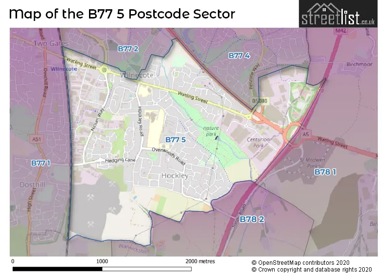
The B77 5 Postcode shares a border with B77 1 (TAMWORTH, Dosthill, Two Gates), B77 2 (TAMWORTH, Glascote, Wilnecote), B77 4 (Wilnecote, TAMWORTH, Amington), B78 1 (Polesworth, Dordon, Birchmoor) and B78 2 (Kingsbury, Middleton, Piccadilly).
The sector is within the post town of TAMWORTH.
B77 5 is a postcode sector within the B7 postcode district which is within the B Birmingham postcode area.
The Royal Mail delivery office for the B77 5 postal sector is the Aston Delivery Office.
The area of the B77 5 postcode sector is 1.57 square miles which is 4.07 square kilometres or 1,006.80 square acres.
The B77 5 postcode sector is crossed by the A5 Major A road.
The B77 5 postcode sector is crossed by the M42 motorway.

Map of the B77 5 Postcode Sector
Explore the B77 5 postcode sector by using our free interactive map.
| B | 7 | 7 | - | 5 | X | X |
| B | 7 | 7 | Space | 5 | Letter | Letter |
Official List of Streets
Wilnecote (97 Streets)
Hockley (25 Streets)
Unofficial Streets or Alternative Spellings
Wilnecote
GLASCOTE LANE NINEFOOT LANE SANDSTONE COURTDordon
WATLING STREET ARRONS COURT CENTURION WAY CHATHAM WAY CUPRONICKLE WAY FREASLEY LANE PENNINE WAY TAMWORTH INTERCHANGE TOWN WALLDosthill
HEDGING LANE RUSH LANETAMWORTH
HILMORE WAY MARLBOROUGH WAY WILNECOTE LANEFazeley
WATLING STREETWeather Forecast for B77 5
Press Button to Show Forecast for Snowdome Tamworth
| Time Period | Icon | Description | Temperature | Rain Probability | Wind |
|---|---|---|---|---|---|
| 06:00 to 09:00 | Overcast | 11.0°C (feels like 10.0°C) | 9.00% | ESE 4 mph | |
| 09:00 to 12:00 | Cloudy | 14.0°C (feels like 13.0°C) | 4.00% | E 4 mph | |
| 12:00 to 15:00 | Cloudy | 16.0°C (feels like 15.0°C) | 16.00% | ENE 4 mph | |
| 15:00 to 18:00 | Cloudy | 16.0°C (feels like 15.0°C) | 14.00% | NE 7 mph | |
| 18:00 to 21:00 | Cloudy | 15.0°C (feels like 14.0°C) | 50.00% | NNE 9 mph | |
| 21:00 to 00:00 | Cloudy | 14.0°C (feels like 12.0°C) | 7.00% | NNE 9 mph |
Press Button to Show Forecast for Snowdome Tamworth
| Time Period | Icon | Description | Temperature | Rain Probability | Wind |
|---|---|---|---|---|---|
| 00:00 to 03:00 | Overcast | 11.0°C (feels like 9.0°C) | 10.00% | NNE 11 mph | |
| 03:00 to 06:00 | Overcast | 11.0°C (feels like 9.0°C) | 15.00% | NE 9 mph | |
| 06:00 to 09:00 | Overcast | 11.0°C (feels like 8.0°C) | 9.00% | NNE 11 mph | |
| 09:00 to 12:00 | Cloudy | 13.0°C (feels like 11.0°C) | 5.00% | NE 13 mph | |
| 12:00 to 15:00 | Overcast | 17.0°C (feels like 15.0°C) | 8.00% | NE 11 mph | |
| 15:00 to 18:00 | Cloudy | 19.0°C (feels like 17.0°C) | 5.00% | NE 11 mph | |
| 18:00 to 21:00 | Cloudy | 17.0°C (feels like 15.0°C) | 6.00% | NE 9 mph | |
| 21:00 to 00:00 | Cloudy | 13.0°C (feels like 11.0°C) | 6.00% | NE 9 mph |
Press Button to Show Forecast for Snowdome Tamworth
| Time Period | Icon | Description | Temperature | Rain Probability | Wind |
|---|---|---|---|---|---|
| 00:00 to 03:00 | Overcast | 11.0°C (feels like 10.0°C) | 10.00% | NE 7 mph | |
| 03:00 to 06:00 | Overcast | 11.0°C (feels like 10.0°C) | 13.00% | N 4 mph | |
| 06:00 to 09:00 | Overcast | 11.0°C (feels like 10.0°C) | 15.00% | NNW 4 mph | |
| 09:00 to 12:00 | Overcast | 13.0°C (feels like 11.0°C) | 14.00% | NW 7 mph | |
| 12:00 to 15:00 | Overcast | 15.0°C (feels like 14.0°C) | 14.00% | WNW 9 mph | |
| 15:00 to 18:00 | Cloudy | 16.0°C (feels like 14.0°C) | 14.00% | WNW 9 mph | |
| 18:00 to 21:00 | Overcast | 15.0°C (feels like 13.0°C) | 21.00% | WNW 9 mph | |
| 21:00 to 00:00 | Cloudy | 13.0°C (feels like 11.0°C) | 11.00% | WNW 9 mph |
Press Button to Show Forecast for Snowdome Tamworth
| Time Period | Icon | Description | Temperature | Rain Probability | Wind |
|---|---|---|---|---|---|
| 00:00 to 03:00 | Partly cloudy (night) | 11.0°C (feels like 9.0°C) | 7.00% | W 7 mph | |
| 03:00 to 06:00 | Cloudy | 10.0°C (feels like 8.0°C) | 9.00% | W 7 mph | |
| 06:00 to 09:00 | Cloudy | 10.0°C (feels like 8.0°C) | 10.00% | WSW 7 mph | |
| 09:00 to 12:00 | Cloudy | 13.0°C (feels like 11.0°C) | 8.00% | WSW 7 mph | |
| 12:00 to 15:00 | Cloudy | 15.0°C (feels like 14.0°C) | 10.00% | SW 7 mph | |
| 15:00 to 18:00 | Cloudy | 17.0°C (feels like 15.0°C) | 11.00% | SSW 9 mph | |
| 18:00 to 21:00 | Cloudy | 16.0°C (feels like 14.0°C) | 9.00% | W 7 mph | |
| 21:00 to 00:00 | Cloudy | 13.0°C (feels like 12.0°C) | 7.00% | WNW 7 mph |
Schools and Places of Education Within the B77 5 Postcode Sector
The Wilnecote School
Academy converter
Tinkers Green Road, Tamworth, Staffordshire, B77 5LF
Head: Mr David Foskett
Ofsted Rating: Good
Inspection: 2022-10-12 (567 days ago)
Website: Visit The Wilnecote School Website
Phone: 01827831300
Number of Pupils: 888
House Prices in the B77 5 Postcode Sector
| Type of Property | 2018 Average | 2018 Sales | 2017 Average | 2017 Sales | 2016 Average | 2016 Sales | 2015 Average | 2015 Sales |
|---|---|---|---|---|---|---|---|---|
| Detached | £272,206 | 31 | £266,825 | 43 | £258,370 | 62 | £227,838 | 52 |
| Semi-Detached | £169,185 | 51 | £166,101 | 64 | £160,835 | 55 | £150,372 | 47 |
| Terraced | £159,013 | 35 | £148,233 | 33 | £146,492 | 32 | £136,357 | 35 |
| Flats | £114,521 | 12 | £106,780 | 15 | £111,372 | 25 | £98,119 | 16 |
Important Postcodes B77 5 in the Postcode Sector
B77 5HP is the postcode for The Wellbeing Centre, 3 Beauchamp Road
B77 5LA is the postcode for Staffordshire County Council, Wilnecote Junior School, Smithy Lane, and WILNECOTE JUNIOR SCHOOL, SMITHY LANE, WILNECOTE
B77 5LB is the postcode for Wilnecote Health Centre, 49 Smithy Lane
B77 5LF is the postcode for The Wilnecote School, Tinkers Green Road, Wilnecote, and Staffordshire County Council, Wilnecote High School, Tinkers Green Road
B77 5LU is the postcode for HEATHFIELDS INFANT SCHOOL, SAXON CLOSE, HOCKLEY, and Staffordshire County Council, Heathfields County Infants School, Saxon Close
| The B77 5 Sector is within these Local Authorities |
|
|---|---|
| The B77 5 Sector is within these Counties |
|
| The B77 5 Sector is within these Water Company Areas |
|