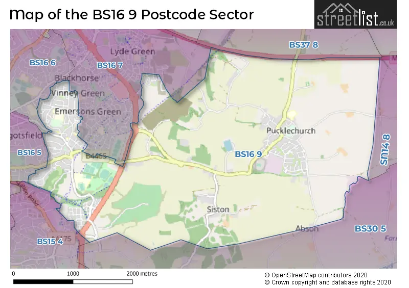
The BS16 9 postcode sector is within the county of Gloucestershire.
Did you know? According to the 2021 Census, the BS16 9 postcode sector is home to a bustling 10,137 residents!
Given that each sector allows for 400 unique postcode combinations. Letters C, I, K, M, O and V are not allowed in the last two letters of a postcode. With 216 postcodes already in use, this leaves 184 units available.
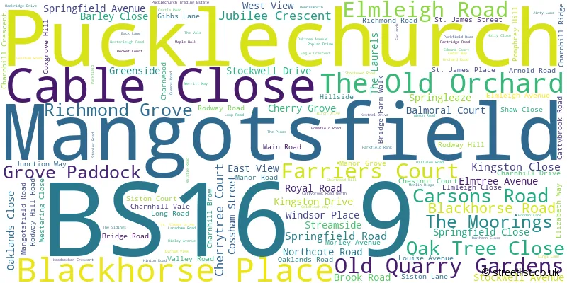
The largest settlements in the BS16 9 postal code are Mangotsfield and Pucklechurch.
The BS16 9 Postcode shares a border with SN14 8 (Colerne, Marshfield, North Colerne), BS15 4 (BRISTOL, Kingswood, Warmley), BS16 5 (BRISTOL, Staple Hill, Downend), BS16 6 (BRISTOL, Downend), BS16 7 (Emersons Green), BS30 5 (Wick, BRISTOL, Warmley) and BS37 8 (Yate, Westerleigh).
The sector is within the post town of BRISTOL.
BS16 9 is a postcode sector within the BS1 postcode district which is within the BS Bristol postcode area.
The Royal Mail delivery office for the BS16 9 postal sector is the unknown.
The area of the BS16 9 postcode sector is 5.31 square miles which is 13.76 square kilometres or 3,399.31 square acres.
The BS16 9 postcode sector is crossed by the M4 motorway.

Map of the BS16 9 Postcode Sector
Explore the BS16 9 postcode sector by using our free interactive map.
| B | S | 1 | 6 | - | 9 | X | X |
| B | S | 1 | 6 | Space | 9 | Letter | Letter |
Official List of Streets
Pucklechurch (44 Streets)
Mangotsfield (79 Streets)
Unofficial Streets or Alternative Spellings
Kingswood
BRIDGE ROAD "UP POMPHREY" BRAMBLE CLOSE BRISTOL & BATH RAILWAY PATH BRISTOL AND GLOUCESTERSHIRE RAILWAY CARSONS ROAD LINK CATTYBROOK ROAD NORTH CAULIFLOWER CLOSE CHARNHILL FOOTBRIDGE CROCUS ROAD DRAMWAY ROUNDABOUT GOOSEFOOT ROAD HAWTHORNE CLOSE HILL VIEW ROAD HYACINTH CLOSE HYACINTH WAY LILY ROAD MERRITT ROAD REDFORD LANE RING ROAD PATH SAINT ALDAMS DRIVE SAINT JAMESS STREET SISTON HILL ROUNDABOUT WOODSAGE CRESCENT WOODSAGE ROADPucklechurch
PARKFIELD RANKEmersons Green
CORNFLOWER ROAD COSSHAM STREET COTTONGRASS ROAD EMERSONS GREEN LANE EMET GROVE HONEYSUCKLE ROAD JOHNSON ROAD PEAR TREE WAY SNAPDRAGON WAY SUNDEW ROAD VIOLA WAY WALLFLOWER CLOSE WILLOWHERB ROAD YARROW WALKCoalpit Heath
WESTERLEIGH ROADDownend
NORTHCOTE ROADWeather Forecast for BS16 9
Press Button to Show Forecast for Rodway Hill
| Time Period | Icon | Description | Temperature | Rain Probability | Wind |
|---|---|---|---|---|---|
| 00:00 to 03:00 | Clear night | 10.0°C (feels like 9.0°C) | 0.00% | SW 4 mph | |
| 03:00 to 06:00 | Clear night | 8.0°C (feels like 7.0°C) | 0.00% | SSE 2 mph | |
| 06:00 to 09:00 | Sunny day | 8.0°C (feels like 8.0°C) | 3.00% | ESE 2 mph | |
| 09:00 to 12:00 | Partly cloudy (day) | 14.0°C (feels like 13.0°C) | 4.00% | ESE 7 mph | |
| 12:00 to 15:00 | Cloudy | 16.0°C (feels like 14.0°C) | 7.00% | SE 9 mph | |
| 15:00 to 18:00 | Cloudy | 15.0°C (feels like 13.0°C) | 10.00% | SSE 9 mph | |
| 18:00 to 21:00 | Cloudy | 14.0°C (feels like 13.0°C) | 8.00% | S 4 mph | |
| 21:00 to 00:00 | Cloudy | 12.0°C (feels like 12.0°C) | 9.00% | SE 4 mph |
Press Button to Show Forecast for Rodway Hill
| Time Period | Icon | Description | Temperature | Rain Probability | Wind |
|---|---|---|---|---|---|
| 00:00 to 03:00 | Overcast | 11.0°C (feels like 10.0°C) | 20.00% | SE 2 mph | |
| 03:00 to 06:00 | Cloudy | 10.0°C (feels like 9.0°C) | 12.00% | E 4 mph | |
| 06:00 to 09:00 | Cloudy | 10.0°C (feels like 10.0°C) | 11.00% | NNE 4 mph | |
| 09:00 to 12:00 | Cloudy | 13.0°C (feels like 12.0°C) | 13.00% | NNE 7 mph | |
| 12:00 to 15:00 | Cloudy | 15.0°C (feels like 14.0°C) | 15.00% | NNE 7 mph | |
| 15:00 to 18:00 | Light rain shower (day) | 16.0°C (feels like 15.0°C) | 33.00% | NNW 7 mph | |
| 18:00 to 21:00 | Light rain shower (day) | 15.0°C (feels like 14.0°C) | 32.00% | NNW 7 mph | |
| 21:00 to 00:00 | Cloudy | 12.0°C (feels like 11.0°C) | 6.00% | NNW 7 mph |
Press Button to Show Forecast for Rodway Hill
| Time Period | Icon | Description | Temperature | Rain Probability | Wind |
|---|---|---|---|---|---|
| 00:00 to 03:00 | Partly cloudy (night) | 11.0°C (feels like 9.0°C) | 2.00% | NNW 7 mph | |
| 03:00 to 06:00 | Clear night | 10.0°C (feels like 8.0°C) | 1.00% | NNW 7 mph | |
| 06:00 to 09:00 | Partly cloudy (day) | 10.0°C (feels like 9.0°C) | 2.00% | NNW 7 mph | |
| 09:00 to 12:00 | Cloudy | 13.0°C (feels like 12.0°C) | 5.00% | N 7 mph | |
| 12:00 to 15:00 | Cloudy | 16.0°C (feels like 16.0°C) | 6.00% | NNW 7 mph | |
| 15:00 to 18:00 | Cloudy | 18.0°C (feels like 17.0°C) | 7.00% | NW 7 mph | |
| 18:00 to 21:00 | Cloudy | 17.0°C (feels like 17.0°C) | 5.00% | NW 4 mph | |
| 21:00 to 00:00 | Cloudy | 13.0°C (feels like 13.0°C) | 3.00% | NW 4 mph |
Press Button to Show Forecast for Rodway Hill
| Time Period | Icon | Description | Temperature | Rain Probability | Wind |
|---|---|---|---|---|---|
| 00:00 to 03:00 | Clear night | 11.0°C (feels like 10.0°C) | 1.00% | NW 4 mph | |
| 03:00 to 06:00 | Cloudy | 9.0°C (feels like 8.0°C) | 4.00% | N 4 mph | |
| 06:00 to 09:00 | Cloudy | 10.0°C (feels like 9.0°C) | 4.00% | NNE 4 mph | |
| 09:00 to 12:00 | Cloudy | 14.0°C (feels like 14.0°C) | 4.00% | NNE 4 mph | |
| 12:00 to 15:00 | Cloudy | 17.0°C (feels like 17.0°C) | 4.00% | NNW 4 mph | |
| 15:00 to 18:00 | Cloudy | 19.0°C (feels like 18.0°C) | 4.00% | NNW 4 mph | |
| 18:00 to 21:00 | Cloudy | 18.0°C (feels like 17.0°C) | 4.00% | NW 4 mph | |
| 21:00 to 00:00 | Cloudy | 13.0°C (feels like 13.0°C) | 4.00% | SSW 4 mph |
Schools and Places of Education Within the BS16 9 Postcode Sector
Barley Close Community Primary School
Community school
Barley Close, Bristol, , BS16 9DL
Head: Mrs Jo Williams
Ofsted Rating: Good
Inspection: 2023-06-08 (332 days ago)
Website: Visit Barley Close Community Primary School Website
Phone: 01454867090
Number of Pupils: 278
Mangotsfield School
Academy sponsor led
Rodway Hill, Bristol, , BS16 9LH
Head: Mrs Hetty Blackmore
Ofsted Rating: Good
Inspection: 2022-03-02 (795 days ago)
Website: Visit Mangotsfield School Website
Phone: 01454862700
Number of Pupils: 1094
Pucklechurch CofE VC Primary School
Voluntary controlled school
Castle Road, Bristol, South Gloucestershire, BS16 9RF
Head: Mrs Alexandra Capel
Ofsted Rating: Good
Inspection: 2023-03-01 (431 days ago)
Website: Visit Pucklechurch CofE VC Primary School Website
Phone: 01179372579
Number of Pupils: 192
House Prices in the BS16 9 Postcode Sector
| Type of Property | 2018 Average | 2018 Sales | 2017 Average | 2017 Sales | 2016 Average | 2016 Sales | 2015 Average | 2015 Sales |
|---|---|---|---|---|---|---|---|---|
| Detached | £467,442 | 18 | £438,378 | 25 | £362,497 | 18 | £378,786 | 38 |
| Semi-Detached | £280,947 | 53 | £274,684 | 59 | £256,089 | 37 | £233,288 | 40 |
| Terraced | £249,999 | 64 | £246,612 | 43 | £217,465 | 55 | £210,923 | 60 |
| Flats | £159,665 | 34 | £153,675 | 26 | £138,534 | 40 | £133,970 | 38 |
Important Postcodes BS16 9 in the Postcode Sector
BS16 9BP is the postcode for Blackhorse Resource & Activity Centre, Blackhorse Road
BS16 9DL is the postcode for Barley Close Community Primary School, Barley Close
BS16 9LH is the postcode for MAIN BLOCK, Mangotsfield School, Rodway Hill, SCIENCE BLOCK, Mangotsfield School, Rodway Hill, A BLOCK & B BLOCK, Mangotsfield School, Rodway Hill, D BLOCK, Mangotsfield School, Rodway Hill, C BLOCK, Mangotsfield School, Rodway Hill, E BLOCK, Mangotsfield School, Rodway Hill, DESIGN & TECHNOLOGY BLOCK, Mangotsfield School, Rodway Hill, and BRUNEL BLOCK, Mangotsfield School, Rodway Hill
BS16 9QJ is the postcode for HMP Ashfield, Shortwood Road, GATEHOUSE, HMP Ashfield, Shortwood Road, and ADMIN RECEPTION BUILDING, HMP Ashfield, Shortwood Road
BS16 9RF is the postcode for Pucklechurch C of E Primary School, Castle Road, and Pucklechurch C of E Primary School, Castle Road, Pucklechurch
| The BS16 9 Sector is within these Local Authorities |
|
|---|---|
| The BS16 9 Sector is within these Counties |
|
| The BS16 9 Sector is within these Water Company Areas |
|