The DA9 9 postcode sector is within the county of Kent.
Did you know? According to the 2021 Census, the DA9 9 postcode sector is home to a bustling 15,244 residents!
Given that each sector allows for 400 unique postcode combinations. Letters C, I, K, M, O and V are not allowed in the last two letters of a postcode. With 315 postcodes already in use, this leaves 85 units available.
The largest settlement in the DA9 9 postal code is GREENHITHE followed by STONE , and HORNS CROSS .
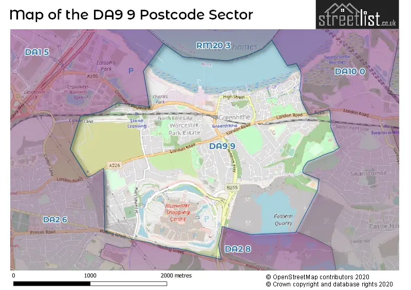
The DA9 9 Postcode shares a border with DA2 6 (DARTFORD, STONE, DARENTH), DA2 8 (BEAN, DARENTH, DARTFORD) and DA10 0 (SWANSCOMBE).
The sector is within the post town of GREENHITHE.
DA9 9 is a postcode sector within the DA9 postcode district which is within the DA Dartford postcode area.
The Royal Mail delivery office for the DA9 9 postal sector is the Swanscombe Delivery Office.
The area of the DA9 9 postcode sector is 2.19 square miles which is 5.66 square kilometres or 1,399.41 square acres.

Map of the DA9 9 Postcode Sector
Explore the DA9 9 postcode sector by using our free interactive map.
| D | A | 9 | - | 9 | X | X |
| D | A | 9 | Space | 9 | Letter | Letter |
Official List of Streets
GREENHITHE (184 Streets)
Bluewater (11 Streets)
Unofficial Streets or Alternative Spellings
SWANSCOMBE
ALKERDEN LANE CRAYLANDS LANE CRESSWELL ROADGREENHITHE
ST. CLEMENTS ROADStone
LONDON ROADBean
WATLING STREET BAZLEY CLOSE CAWDOR CLOSE CHERRY HINTON CLOSE CHESTNUT AVENUE CLARE CAUSEWAY COBHAM TERRACE ROAD CUTTY SARK COURT DS5 DS6 DS7 EASTERN AVENUE ECCLESTONE ROAD FAIRLAWN CRESENT GANTRY PLACE GUILDHALL IVY VILLAS LIME TREE AVENUE LONGHOUGHTON AVENUE MAPLE COURT MOUNT NOD OAK TREE AVENUE ORCHARD TERRACE ROSE GALLERY SISKIN DRIVE SMUGGLERS WHARF ST CLEMENTS WAY SYCAMORE COURT THAMES WALK THE VILLAGE CRESCENT TILTMAN AVENUE TOWN SQUARE CRESCENT VALLEY GARDENS WINTERGARDEN CRESCENTDARTFORD,
COTTON LANE CROSSWAYS BOULEVARDCrossways Business Park
CLAIRE CAUSEWAYWeather Forecast for DA9 9
Press Button to Show Forecast for Gravesend-Broadness
| Time Period | Icon | Description | Temperature | Rain Probability | Wind |
|---|---|---|---|---|---|
| 09:00 to 12:00 | Cloudy | 9.0°C (feels like 6.0°C) | 14.00% | NE 11 mph | |
| 12:00 to 15:00 | Cloudy | 12.0°C (feels like 10.0°C) | 36.00% | ENE 9 mph | |
| 15:00 to 18:00 | Cloudy | 13.0°C (feels like 11.0°C) | 11.00% | ENE 9 mph | |
| 18:00 to 21:00 | Cloudy | 11.0°C (feels like 9.0°C) | 49.00% | ENE 11 mph | |
| 21:00 to 00:00 | Heavy rain | 10.0°C (feels like 7.0°C) | 88.00% | NE 11 mph |
Press Button to Show Forecast for Gravesend-Broadness
| Time Period | Icon | Description | Temperature | Rain Probability | Wind |
|---|---|---|---|---|---|
| 00:00 to 03:00 | Heavy rain | 10.0°C (feels like 7.0°C) | 91.00% | NE 11 mph | |
| 03:00 to 06:00 | Heavy rain | 9.0°C (feels like 7.0°C) | 89.00% | ENE 9 mph | |
| 06:00 to 09:00 | Heavy rain | 10.0°C (feels like 8.0°C) | 84.00% | S 7 mph | |
| 09:00 to 12:00 | Heavy rain | 10.0°C (feels like 8.0°C) | 81.00% | W 9 mph | |
| 12:00 to 15:00 | Light rain | 11.0°C (feels like 8.0°C) | 57.00% | W 11 mph | |
| 15:00 to 18:00 | Overcast | 11.0°C (feels like 9.0°C) | 19.00% | W 11 mph | |
| 18:00 to 21:00 | Cloudy | 11.0°C (feels like 9.0°C) | 10.00% | WSW 9 mph | |
| 21:00 to 00:00 | Partly cloudy (night) | 9.0°C (feels like 7.0°C) | 3.00% | SW 7 mph |
Press Button to Show Forecast for Gravesend-Broadness
| Time Period | Icon | Description | Temperature | Rain Probability | Wind |
|---|---|---|---|---|---|
| 00:00 to 03:00 | Clear night | 7.0°C (feels like 6.0°C) | 2.00% | SW 4 mph | |
| 03:00 to 06:00 | Clear night | 7.0°C (feels like 5.0°C) | 1.00% | SSW 4 mph | |
| 06:00 to 09:00 | Sunny day | 8.0°C (feels like 6.0°C) | 1.00% | S 4 mph | |
| 09:00 to 12:00 | Partly cloudy (day) | 13.0°C (feels like 11.0°C) | 3.00% | S 9 mph | |
| 12:00 to 15:00 | Cloudy | 15.0°C (feels like 12.0°C) | 7.00% | S 11 mph | |
| 15:00 to 18:00 | Cloudy | 15.0°C (feels like 13.0°C) | 5.00% | SSE 11 mph | |
| 18:00 to 21:00 | Sunny day | 14.0°C (feels like 12.0°C) | 4.00% | SSE 9 mph | |
| 21:00 to 00:00 | Clear night | 10.0°C (feels like 8.0°C) | 1.00% | SE 7 mph |
Press Button to Show Forecast for Gravesend-Broadness
| Time Period | Icon | Description | Temperature | Rain Probability | Wind |
|---|---|---|---|---|---|
| 00:00 to 03:00 | Clear night | 9.0°C (feels like 7.0°C) | 2.00% | SE 7 mph | |
| 03:00 to 06:00 | Clear night | 8.0°C (feels like 7.0°C) | 3.00% | ESE 7 mph | |
| 06:00 to 09:00 | Cloudy | 10.0°C (feels like 8.0°C) | 9.00% | ESE 7 mph | |
| 09:00 to 12:00 | Cloudy | 14.0°C (feels like 12.0°C) | 8.00% | ESE 7 mph | |
| 12:00 to 15:00 | Cloudy | 16.0°C (feels like 14.0°C) | 12.00% | SE 9 mph | |
| 15:00 to 18:00 | Cloudy | 16.0°C (feels like 14.0°C) | 13.00% | ESE 9 mph | |
| 18:00 to 21:00 | Cloudy | 15.0°C (feels like 14.0°C) | 10.00% | ESE 9 mph | |
| 21:00 to 00:00 | Cloudy | 12.0°C (feels like 11.0°C) | 10.00% | E 7 mph |
Schools and Places of Education Within the DA9 9 Postcode Sector
Knockhall Primary School
Academy sponsor led
Eynsford Road, Greenhithe, Kent, DA9 9RF
Head: Miss Kathryn Yiannadji
Ofsted Rating: Requires improvement
Inspection: 2023-06-21 (311 days ago)
Website: Visit Knockhall Primary School Website
Phone: 01322382053
Number of Pupils: 385
Stone St Mary's CofE Primary School
Academy converter
Hayes Road, Greenhithe, Kent, DA9 9EF
Head: Mrs Jane Rolfe
Ofsted Rating: Good
Inspection: 2020-02-05 (1543 days ago)
Website: Visit Stone St Mary's CofE Primary School Website
Phone: 01322382292
Number of Pupils: 645
House Prices in the DA9 9 Postcode Sector
| Type of Property | 2018 Average | 2018 Sales | 2017 Average | 2017 Sales | 2016 Average | 2016 Sales | 2015 Average | 2015 Sales |
|---|---|---|---|---|---|---|---|---|
| Detached | £470,105 | 38 | £462,458 | 25 | £487,039 | 37 | £343,488 | 20 |
| Semi-Detached | £380,204 | 70 | £381,311 | 74 | £344,813 | 80 | £296,968 | 33 |
| Terraced | £319,083 | 105 | £335,682 | 139 | £309,886 | 123 | £271,995 | 120 |
| Flats | £209,528 | 204 | £209,023 | 193 | £215,189 | 208 | £200,539 | 261 |
Important Postcodes DA9 9 in the Postcode Sector
DA9 9EF is the postcode for CANTERBURY BUILDING, Stone St Mary's CofE Primary School, Hayes Road, TONBRIDGE BUILDING, Stone St. Mary's CE Primary School, Hayes Road, CLASSROOM BLOCK 2005, Stone C of E Primary School, Hayes Road, and Stone C of E Primary School, Hayes Road
DA9 9HB is the postcode for Knockhall Primary School, Eynsford Road
DA9 9RF is the postcode for Knockhall Primary School, Eynsford Road, Greenhithe, and Knockhall Primary School, Eynsford Road
| The DA9 9 Sector is within these Local Authorities |
|
|---|---|
| The DA9 9 Sector is within these Counties |
|
| The DA9 9 Sector is within these Water Company Areas |
|