The E13 0 postcode sector is within the county of Greater London.
Did you know? According to the 2021 Census, the E13 0 postcode sector is home to a bustling 19,749 residents!
Given that each sector allows for 400 unique postcode combinations. Letters C, I, K, M, O and V are not allowed in the last two letters of a postcode. With 185 postcodes already in use, this leaves 215 units available.
The largest settlement in the E13 0 postal code is PLAISTOW followed by UPTON PARK , and STRATFORD .
The E13 0 Postcode shares a border with E6 1 (EAST HAM ), E7 8 (FOREST GATE , MANOR PARK ), E7 9 (FOREST GATE , STRATFORD ), E13 8 (PLAISTOW ), E13 9 (PLAISTOW , UPTON PARK , EAST HAM ), E15 3 (STRATFORD ) and E16 4 (CANNING TOWN , PLAISTOW ).
The sector is within the post town of LONDON.
E13 0 is a postcode sector within the E13 postcode district which is within the E East London postcode area.
The Royal Mail delivery office for the E13 0 postal sector is the Plaistow Sdelivery Office.
The area of the E13 0 postcode sector is 0.47 square miles which is 1.21 square kilometres or 298.58 square acres.

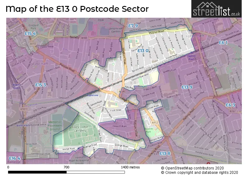
Map of the E13 0 Postcode Sector
Explore the E13 0 postcode sector by using our free interactive map.
| E | 1 | 3 | - | 0 | X | X |
| E | 1 | 3 | Space | 0 | Letter | Letter |
Official List of Streets
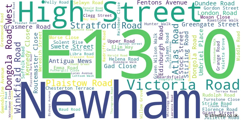
Newham (87 Streets)
Unofficial Streets or Alternative Spellings
Newham
BALAAM STREET CHENAPPA CLOSE CHESTERTON ROAD EAST ROAD FIRST AVENUE GAINSBOROUGH ROAD GREEN STREET HERBERT STREET HERMIT ROAD HOLLYBUSH STREET HYDE CLOSE LIDDON ROAD MORLEY ROAD NORTH STREET PERTH ROAD RICHMOND STREET RONALD AVENUE SOUTHERN ROAD STUKELEY ROAD SWILLY MEWS THIRD AVENUE UPTON LANE WEST ROAD WHITWELL ROAD ASHBURTON TERRACE AYRES CLOSE BARBERS ALLEY BAZELGETTE VILLAS BEST COURT CARTER ROAD COLNE STREET GREENWAY HIGH STREET SOUTH MAUD GARDENS MAY ROAD QUEENS ROAD ST ANTONYS ROAD ST MARYS ROAD ST QUINTIN ROAD THE BROADWAY WINIFRED TERRACEWeather Forecast for E13 0
Press Button to Show Forecast for West Ham United F.C.
| Time Period | Icon | Description | Temperature | Rain Probability | Wind |
|---|---|---|---|---|---|
| 03:00 to 06:00 | Clear night | 8.0°C (feels like 6.0°C) | 0.00% | SSW 7 mph | |
| 06:00 to 09:00 | Sunny day | 8.0°C (feels like 6.0°C) | 0.00% | S 7 mph | |
| 09:00 to 12:00 | Sunny day | 13.0°C (feels like 10.0°C) | 0.00% | SSW 11 mph | |
| 12:00 to 15:00 | Sunny day | 16.0°C (feels like 12.0°C) | 0.00% | SSW 13 mph | |
| 15:00 to 18:00 | Sunny day | 16.0°C (feels like 13.0°C) | 0.00% | SSW 13 mph | |
| 18:00 to 21:00 | Sunny day | 15.0°C (feels like 12.0°C) | 0.00% | SSW 11 mph | |
| 21:00 to 00:00 | Clear night | 12.0°C (feels like 10.0°C) | 0.00% | SSE 7 mph |
Press Button to Show Forecast for West Ham United F.C.
| Time Period | Icon | Description | Temperature | Rain Probability | Wind |
|---|---|---|---|---|---|
| 00:00 to 03:00 | Clear night | 11.0°C (feels like 9.0°C) | 0.00% | SE 7 mph | |
| 03:00 to 06:00 | Clear night | 9.0°C (feels like 8.0°C) | 0.00% | ESE 4 mph | |
| 06:00 to 09:00 | Sunny day | 10.0°C (feels like 9.0°C) | 1.00% | SE 4 mph | |
| 09:00 to 12:00 | Sunny day | 15.0°C (feels like 13.0°C) | 3.00% | SE 9 mph | |
| 12:00 to 15:00 | Cloudy | 17.0°C (feels like 14.0°C) | 8.00% | SSE 11 mph | |
| 15:00 to 18:00 | Cloudy | 16.0°C (feels like 14.0°C) | 10.00% | SSE 11 mph | |
| 18:00 to 21:00 | Cloudy | 15.0°C (feels like 14.0°C) | 10.00% | SSE 7 mph | |
| 21:00 to 00:00 | Partly cloudy (night) | 13.0°C (feels like 12.0°C) | 8.00% | SE 4 mph |
Press Button to Show Forecast for West Ham United F.C.
| Time Period | Icon | Description | Temperature | Rain Probability | Wind |
|---|---|---|---|---|---|
| 00:00 to 03:00 | Cloudy | 12.0°C (feels like 11.0°C) | 9.00% | SE 4 mph | |
| 03:00 to 06:00 | Cloudy | 11.0°C (feels like 10.0°C) | 8.00% | SSE 4 mph | |
| 06:00 to 09:00 | Cloudy | 11.0°C (feels like 11.0°C) | 10.00% | SSW 4 mph | |
| 09:00 to 12:00 | Cloudy | 13.0°C (feels like 13.0°C) | 11.00% | ENE 4 mph | |
| 12:00 to 15:00 | Cloudy | 16.0°C (feels like 16.0°C) | 11.00% | ESE 4 mph | |
| 15:00 to 18:00 | Cloudy | 17.0°C (feels like 16.0°C) | 14.00% | E 7 mph | |
| 18:00 to 21:00 | Cloudy | 16.0°C (feels like 15.0°C) | 10.00% | ESE 7 mph | |
| 21:00 to 00:00 | Cloudy | 14.0°C (feels like 13.0°C) | 10.00% | N 7 mph |
Press Button to Show Forecast for West Ham United F.C.
| Time Period | Icon | Description | Temperature | Rain Probability | Wind |
|---|---|---|---|---|---|
| 00:00 to 03:00 | Light rain shower (night) | 12.0°C (feels like 11.0°C) | 45.00% | N 7 mph | |
| 03:00 to 06:00 | Overcast | 11.0°C (feels like 10.0°C) | 27.00% | NNW 7 mph | |
| 06:00 to 09:00 | Overcast | 11.0°C (feels like 10.0°C) | 16.00% | NW 7 mph | |
| 09:00 to 12:00 | Cloudy | 14.0°C (feels like 13.0°C) | 11.00% | NW 7 mph | |
| 12:00 to 15:00 | Partly cloudy (day) | 17.0°C (feels like 16.0°C) | 5.00% | NW 9 mph | |
| 15:00 to 18:00 | Partly cloudy (day) | 19.0°C (feels like 17.0°C) | 5.00% | N 9 mph | |
| 18:00 to 21:00 | Partly cloudy (day) | 18.0°C (feels like 16.0°C) | 5.00% | N 9 mph | |
| 21:00 to 00:00 | Partly cloudy (night) | 15.0°C (feels like 13.0°C) | 5.00% | NW 9 mph |
Schools and Places of Education Within the E13 0 Postcode Sector
Curwen Primary School
Academy converter
Atlas Road, London, , E13 0AG
Head: Mr Paul Harris
Ofsted Rating: Outstanding
Inspection: 2023-11-23 (158 days ago)
Website: Visit Curwen Primary School Website
Phone: 02084720290
Number of Pupils: 893
Grange Primary School
Community school
Suffolk Road, London, , E13 0HE
Head: Mrs D Smith
Ofsted Rating: Good
Inspection: 2022-12-14 (502 days ago)
Website: Visit Grange Primary School Website
Phone: 02074765146
Number of Pupils: 205
Portway Primary School
Academy sponsor led
Stratford Road, London, , E13 0JW
Head: Mr Scott Chudley
Ofsted Rating: Outstanding
Inspection: 2019-03-28 (1859 days ago)
Website: Visit Portway Primary School Website
Phone: 02084727142
Number of Pupils: 536
Upton Cross Primary School
Academy converter
Churston Avenue & Kirton Road, London, , E13 0RJ
Head: Charlotte Moore
Ofsted Rating: Good
Inspection: 2020-02-06 (1544 days ago)
Website: Visit Upton Cross Primary School Website
Phone: 02085521081
Number of Pupils: 725
House Prices in the E13 0 Postcode Sector
| Type of Property | 2018 Average | 2018 Sales | 2017 Average | 2017 Sales | 2016 Average | 2016 Sales | 2015 Average | 2015 Sales |
|---|---|---|---|---|---|---|---|---|
| Detached | £0 | 0 | £352,000 | 1 | £0 | 0 | £0 | 0 |
| Semi-Detached | £562,500 | 2 | £459,500 | 5 | £570,500 | 1 | £404,600 | 5 |
| Terraced | £447,184 | 56 | £428,968 | 45 | £386,399 | 61 | £347,445 | 61 |
| Flats | £283,934 | 33 | £249,764 | 57 | £256,251 | 50 | £232,777 | 70 |
Important Postcodes E13 0 in the Postcode Sector
E13 0AA is the postcode for Royal Mail, Plaistow Delivery Office, High Street
E13 0AG is the postcode for Curwen Primary School, Atlas Road, and LONDON BOROUGH OF NEWHAM, Curwen Primary School, Atlas Road
E13 0AN is the postcode for Dongola Road Project Stay & Play, 99-101 Dongola Road West
E13 0ES is the postcode for New Block, Selwyn Primary School, Selwyn Road, and Main Block, Selwyn Primary School, Selwyn Road
E13 0HE is the postcode for LONDON BOROUGH OF NEWHAM, Grange Infant School, Suffolk Road, and Grange Infant School, Suffolk Road
E13 0JW is the postcode for LONDON BOROUGH OF NEWHAM, Portway School, Stratford Road, Portway Primary School, Stratford Road, Plaistow, and Portway School, Stratford Road
E13 0LX is the postcode for Selwyn Primary School, Cecil Road, and LONDON BOROUGH OF NEWHAM, Selwyn Primary School, Cecil Road
E13 0QB is the postcode for Management Committee, Upton Centre, Claude Road, and LONDON BOROUGH OF NEWHAM, Upton Centre, Claude Road
E13 0RJ is the postcode for Upton Cross Primary School, Churston Avenue, LONDON BOROUGH OF NEWHAM, Upton Cross Primary School, Churston Avenue, and Main Building, Upton Cross Primary School, Churston Ave
| The E13 0 Sector is within these Local Authorities |
|
|---|---|
| The E13 0 Sector is within these Counties |
|
| The E13 0 Sector is within these Water Company Areas |
|