The E18 postcode district is a postal district located in the E London - E postcode area with a population of 20,625 residents according to the 2021 England and Wales Census.
The area of the E18 postcode district is 1.17 square miles which is 3.03 square kilometres or 749.71 acres.
Currently, the E18 district has about 368 postcode units spread across 2 geographic postcode sectors.
Given that each sector allows for 400 unique postcode combinations, the district has a capacity of 800 postcodes. With 368 postcodes already in use, this leaves 432 units available.
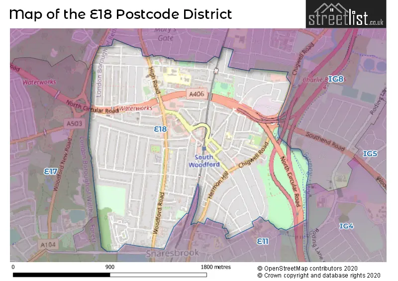
The E18 postal code covers the settlement of SOUTH WOODFORD.
The E18 Postcode shares a border with E11 (LEYTONSTONE, WANSTEAD) and IG8 (WOODFORD GREEN).
The primary settlement in the E18 postcode district is Redbridge, located in Greater London. Other significant settlements in this postcode district are not mentioned. The most significant Postal Town in the E18 postcode district is London.
For the district E18, we have data on 3 postcode sectors. Here's a breakdown: The sector E18 1, covers Redbridge in Greater London. The sector E18 2, covers Redbridge in Greater London. The sector E18 9 is non-geographic. It's often designated for PO Boxes, large organisations, or special services.


Map of the E18 Postcode District
Explore the E18 postcode district by using our free interactive map.
When it comes to local government, postal geography often disregards political borders. However, for a breakdown in the E18 District: the district mostly encompasses the Redbridge London Boro area with a total of 372 postcodes.
Recent House Sales in E18
| Date | Price | Address |
|---|---|---|
| 26/09/2023 | £9,079 | Maybank Road, London, E18 1EL |
| 19/09/2023 | £897,500 | Buckingham Road, South Woodford, London, E18 2NJ |
| 08/09/2023 | £825,000 | Walpole Road, London, E18 2LL |
| 08/09/2023 | £180,000 | Glebelands Avenue, London, E18 2BD |
| 06/09/2023 | £600,000 | Grove Hill, South Woodford, London, E18 2JG |
| 01/09/2023 | £550,000 | Victoria Road, London, E18 1LJ |
| 25/08/2023 | £1,771,000 | Lansdowne Road, London, E18 2BA |
| 25/08/2023 | £405,000 | Althorne Gardens, London, E18 2DA |
| 23/08/2023 | £407,500 | Chigwell Road, South Woodford, London, E18 1FF |
| 21/08/2023 | £810,000 | Hermitage Walk, London, E18 2SR |
Weather Forecast for E18
Press Button to Show Forecast for Walthamstow
| Time Period | Icon | Description | Temperature | Rain Probability | Wind |
|---|---|---|---|---|---|
| 12:00 to 15:00 | Cloudy | 11.0°C (feels like 9.0°C) | 13.00% | NE 7 mph | |
| 15:00 to 18:00 | Cloudy | 12.0°C (feels like 11.0°C) | 12.00% | ENE 7 mph | |
| 18:00 to 21:00 | Light rain | 12.0°C (feels like 10.0°C) | 56.00% | NE 9 mph | |
| 21:00 to 00:00 | Light rain | 10.0°C (feels like 8.0°C) | 67.00% | NE 9 mph |
Press Button to Show Forecast for Walthamstow
| Time Period | Icon | Description | Temperature | Rain Probability | Wind |
|---|---|---|---|---|---|
| 00:00 to 03:00 | Heavy rain | 9.0°C (feels like 6.0°C) | 89.00% | NNE 11 mph | |
| 03:00 to 06:00 | Heavy rain | 9.0°C (feels like 6.0°C) | 89.00% | NNE 9 mph | |
| 06:00 to 09:00 | Heavy rain | 9.0°C (feels like 7.0°C) | 87.00% | N 7 mph | |
| 09:00 to 12:00 | Light rain | 9.0°C (feels like 7.0°C) | 58.00% | WNW 9 mph | |
| 12:00 to 15:00 | Light rain | 10.0°C (feels like 7.0°C) | 54.00% | W 11 mph | |
| 15:00 to 18:00 | Overcast | 11.0°C (feels like 9.0°C) | 20.00% | W 11 mph | |
| 18:00 to 21:00 | Cloudy | 11.0°C (feels like 9.0°C) | 10.00% | W 9 mph | |
| 21:00 to 00:00 | Partly cloudy (night) | 9.0°C (feels like 8.0°C) | 5.00% | SW 7 mph |
Press Button to Show Forecast for Walthamstow
| Time Period | Icon | Description | Temperature | Rain Probability | Wind |
|---|---|---|---|---|---|
| 00:00 to 03:00 | Clear night | 8.0°C (feels like 7.0°C) | 2.00% | SW 4 mph | |
| 03:00 to 06:00 | Clear night | 7.0°C (feels like 5.0°C) | 1.00% | SSW 4 mph | |
| 06:00 to 09:00 | Sunny day | 7.0°C (feels like 6.0°C) | 1.00% | S 4 mph | |
| 09:00 to 12:00 | Sunny day | 12.0°C (feels like 10.0°C) | 1.00% | S 9 mph | |
| 12:00 to 15:00 | Cloudy | 14.0°C (feels like 12.0°C) | 8.00% | S 11 mph | |
| 15:00 to 18:00 | Partly cloudy (day) | 15.0°C (feels like 13.0°C) | 2.00% | S 11 mph | |
| 18:00 to 21:00 | Sunny day | 14.0°C (feels like 12.0°C) | 4.00% | S 9 mph | |
| 21:00 to 00:00 | Clear night | 11.0°C (feels like 10.0°C) | 1.00% | SSE 7 mph |
Press Button to Show Forecast for Walthamstow
| Time Period | Icon | Description | Temperature | Rain Probability | Wind |
|---|---|---|---|---|---|
| 00:00 to 03:00 | Clear night | 10.0°C (feels like 8.0°C) | 1.00% | SE 7 mph | |
| 03:00 to 06:00 | Clear night | 9.0°C (feels like 7.0°C) | 2.00% | ESE 7 mph | |
| 06:00 to 09:00 | Cloudy | 9.0°C (feels like 8.0°C) | 8.00% | ESE 7 mph | |
| 09:00 to 12:00 | Cloudy | 13.0°C (feels like 12.0°C) | 8.00% | ESE 7 mph | |
| 12:00 to 15:00 | Cloudy | 16.0°C (feels like 14.0°C) | 10.00% | SE 9 mph | |
| 15:00 to 18:00 | Cloudy | 17.0°C (feels like 15.0°C) | 12.00% | SE 9 mph | |
| 18:00 to 21:00 | Cloudy | 16.0°C (feels like 14.0°C) | 12.00% | SE 9 mph | |
| 21:00 to 00:00 | Cloudy | 13.0°C (feels like 12.0°C) | 16.00% | ESE 7 mph |
Where is the E18 Postcode District?
The data's postcode district is in the E18 area, which is located in London. This postcode district is surrounded by several nearby towns, including South Woodford to the North East, Woodford Green to the North, Wanstead to the South, Clayhall to the East, Leytonstone to the South West, Gants Hill to the South East, Walthamstow to the West, and Chingford to the North West. The distance from this postcode district to the center of London is approximately 8.82 miles.
The district is within the post town of LONDON.
The sector has postcodes within the nation of England.
The E18 Postcode District is in the Redbridge and Waltham Forest region of Outer London - East and North East within the London.
You may be interested in our page explaining the evolution of London's Postcodes| Postcode Sector | Delivery Office |
|---|---|
| E18 1 | South Woodford Sdelivery Office |
| E18 2 | South Woodford Sdelivery Office |
| E | 1 | 8 | - | X | X | X |
| E | 1 | 8 | Space | Numeric | Letter | Letter |
Current Monthly Rental Prices
| # Bedrooms | Min Price | Max Price | Avg Price |
|---|---|---|---|
| £545 | £1,400 | £873 | |
| 1 | £1,000 | £1,650 | £1,476 |
| 2 | £1,650 | £2,100 | £1,808 |
| 3 | £2,000 | £3,450 | £2,713 |
| 4 | £2,750 | £2,750 | £2,750 |
| 5 | £3,400 | £3,400 | £3,400 |
Current House Prices
| # Bedrooms | Min Price | Max Price | Avg Price |
|---|---|---|---|
| £250,000 | £1,400,000 | £693,750 | |
| 1 | £210,000 | £460,000 | £292,545 |
| 2 | £215,000 | £550,000 | £401,499 |
| 3 | £375,000 | £1,000,000 | £655,454 |
| 4 | £625,000 | £1,250,000 | £915,714 |
| 5 | £790,000 | £2,500,000 | £1,697,500 |
| 6 | £1,500,000 | £2,750,000 | £2,125,000 |
| 8 | £1,500,000 | £1,500,000 | £1,500,000 |
| 9 | £2,695,000 | £2,695,000 | £2,695,000 |
Estate Agents who Operate in the E18 District
| Logo | Name | Brand Name | Address | Contact Number | Total Properties |
|---|---|---|---|---|---|
 | South Woodford | Churchill Estates | 194-196 George Lane South Woodford London E18 1AY | 020 3834 8343 | 15 |
 | South Woodford | haart | 141/143 George Lane, South Woodford, London, E18 1AN | 020 3840 3786 | 15 |
 | London | Neil King | 10 Electric Parade George Lane London E18 2LY | 020 3870 2471 | 15 |
 | South Woodford | The Stow Brothers | 136 George Lane, London, E18 1AY | 020 3319 6533 | 12 |
 | Woodford Green | Bairstow Eves | 411 - 413 High Road, Woodford Green, Essex, IG8 0XG | 020 3835 6392 | 6 |
| Type of Property | 2018 Average | 2018 Sales | 2017 Average | 2017 Sales | 2016 Average | 2016 Sales | 2015 Average | 2015 Sales |
|---|---|---|---|---|---|---|---|---|
| Detached | £1,299,429 | 7 | £894,565 | 10 | £915,385 | 13 | £786,231 | 13 |
| Semi-Detached | £746,167 | 46 | £832,737 | 45 | £769,890 | 41 | £683,632 | 63 |
| Terraced | £666,959 | 70 | £634,237 | 82 | £598,084 | 75 | £566,009 | 90 |
| Flats | £364,159 | 166 | £361,945 | 158 | £360,173 | 171 | £303,133 | 186 |