The E18 2 postcode sector is within the county of Greater London.
Did you know? According to the 2021 Census, the E18 2 postcode sector is home to a bustling 12,159 residents!
Given that each sector allows for 400 unique postcode combinations. Letters C, I, K, M, O and V are not allowed in the last two letters of a postcode. With 208 postcodes already in use, this leaves 192 units available.
The E18 2 postal code covers the settlement of SOUTH WOODFORD .
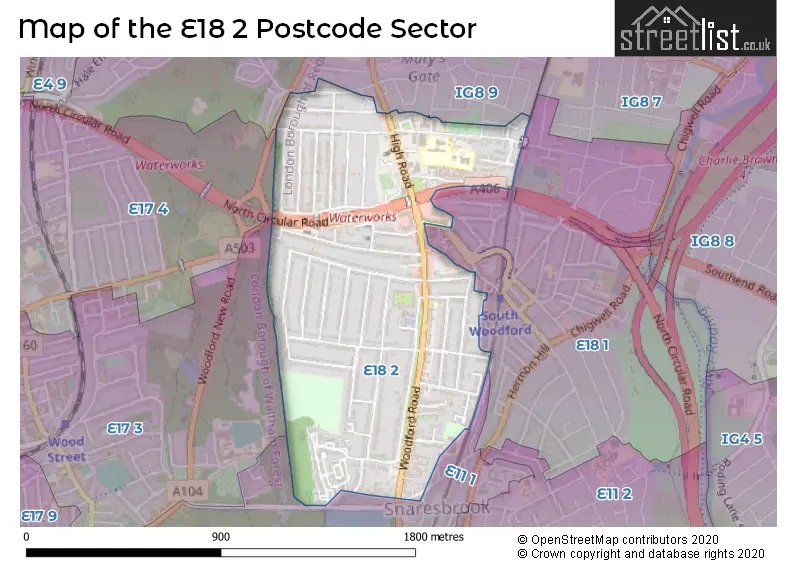
The E18 2 Postcode shares a border with E17 3 (WALTHAMSTOW ), E17 4 (WALTHAMSTOW ), E18 1 (SOUTH WOODFORD , LONDON ), IG8 9 (WOODFORD GREEN ) and E11 1 (LEYTONSTONE , WANSTEAD , LONDON ).
The sector is within the post town of LONDON.
E18 2 is a postcode sector within the E18 postcode district which is within the E East London postcode area.
The Royal Mail delivery office for the E18 2 postal sector is the South Woodford Sdelivery Office.
The area of the E18 2 postcode sector is 0.63 square miles which is 1.63 square kilometres or 401.86 square acres.

Map of the E18 2 Postcode Sector
Explore the E18 2 postcode sector by using our free interactive map.
| E | 1 | 8 | - | 2 | X | X |
| E | 1 | 8 | Space | 2 | Letter | Letter |
Official List of Streets
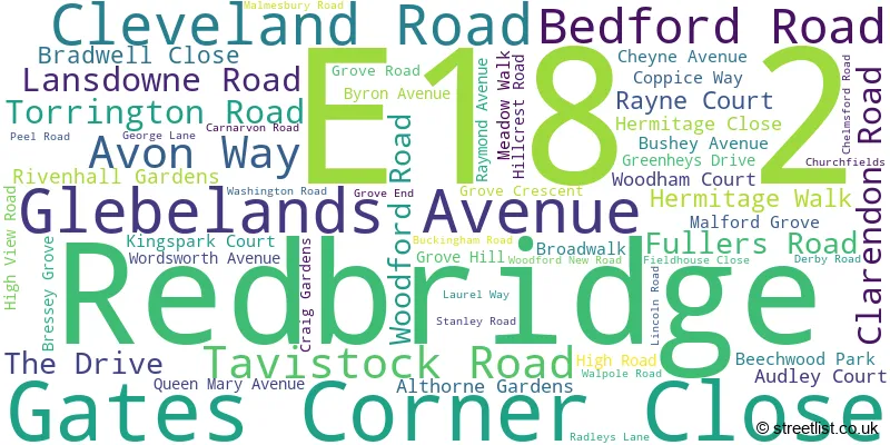
Redbridge (58 Streets)
Unofficial Streets or Alternative Spellings
Weather Forecast for E18 2
Press Button to Show Forecast for Walthamstow
| Time Period | Icon | Description | Temperature | Rain Probability | Wind |
|---|---|---|---|---|---|
| 09:00 to 12:00 | Overcast | 8.0°C (feels like 5.0°C) | 15.00% | NE 9 mph | |
| 12:00 to 15:00 | Cloudy | 11.0°C (feels like 9.0°C) | 13.00% | NE 7 mph | |
| 15:00 to 18:00 | Cloudy | 12.0°C (feels like 11.0°C) | 12.00% | ENE 7 mph | |
| 18:00 to 21:00 | Light rain | 12.0°C (feels like 10.0°C) | 56.00% | NE 9 mph | |
| 21:00 to 00:00 | Light rain | 10.0°C (feels like 8.0°C) | 67.00% | NE 9 mph |
Press Button to Show Forecast for Walthamstow
| Time Period | Icon | Description | Temperature | Rain Probability | Wind |
|---|---|---|---|---|---|
| 00:00 to 03:00 | Heavy rain | 9.0°C (feels like 6.0°C) | 89.00% | NNE 11 mph | |
| 03:00 to 06:00 | Heavy rain | 9.0°C (feels like 6.0°C) | 89.00% | NNE 9 mph | |
| 06:00 to 09:00 | Heavy rain | 9.0°C (feels like 7.0°C) | 87.00% | N 7 mph | |
| 09:00 to 12:00 | Light rain | 9.0°C (feels like 7.0°C) | 58.00% | WNW 9 mph | |
| 12:00 to 15:00 | Light rain | 10.0°C (feels like 7.0°C) | 54.00% | W 11 mph | |
| 15:00 to 18:00 | Overcast | 11.0°C (feels like 9.0°C) | 20.00% | W 11 mph | |
| 18:00 to 21:00 | Cloudy | 11.0°C (feels like 9.0°C) | 10.00% | W 9 mph | |
| 21:00 to 00:00 | Partly cloudy (night) | 9.0°C (feels like 8.0°C) | 5.00% | SW 7 mph |
Press Button to Show Forecast for Walthamstow
| Time Period | Icon | Description | Temperature | Rain Probability | Wind |
|---|---|---|---|---|---|
| 00:00 to 03:00 | Clear night | 8.0°C (feels like 7.0°C) | 2.00% | SW 4 mph | |
| 03:00 to 06:00 | Clear night | 7.0°C (feels like 5.0°C) | 1.00% | SSW 4 mph | |
| 06:00 to 09:00 | Sunny day | 7.0°C (feels like 6.0°C) | 1.00% | S 4 mph | |
| 09:00 to 12:00 | Sunny day | 12.0°C (feels like 10.0°C) | 1.00% | S 9 mph | |
| 12:00 to 15:00 | Cloudy | 14.0°C (feels like 12.0°C) | 8.00% | S 11 mph | |
| 15:00 to 18:00 | Partly cloudy (day) | 15.0°C (feels like 13.0°C) | 2.00% | S 11 mph | |
| 18:00 to 21:00 | Sunny day | 14.0°C (feels like 12.0°C) | 4.00% | S 9 mph | |
| 21:00 to 00:00 | Clear night | 11.0°C (feels like 10.0°C) | 1.00% | SSE 7 mph |
Press Button to Show Forecast for Walthamstow
| Time Period | Icon | Description | Temperature | Rain Probability | Wind |
|---|---|---|---|---|---|
| 00:00 to 03:00 | Clear night | 10.0°C (feels like 8.0°C) | 1.00% | SE 7 mph | |
| 03:00 to 06:00 | Clear night | 9.0°C (feels like 7.0°C) | 2.00% | ESE 7 mph | |
| 06:00 to 09:00 | Cloudy | 9.0°C (feels like 8.0°C) | 8.00% | ESE 7 mph | |
| 09:00 to 12:00 | Cloudy | 13.0°C (feels like 12.0°C) | 8.00% | ESE 7 mph | |
| 12:00 to 15:00 | Cloudy | 16.0°C (feels like 14.0°C) | 10.00% | SE 9 mph | |
| 15:00 to 18:00 | Cloudy | 17.0°C (feels like 15.0°C) | 12.00% | SE 9 mph | |
| 18:00 to 21:00 | Cloudy | 16.0°C (feels like 14.0°C) | 12.00% | SE 9 mph | |
| 21:00 to 00:00 | Cloudy | 13.0°C (feels like 12.0°C) | 16.00% | ESE 7 mph |
Schools and Places of Education Within the E18 2 Postcode Sector
Churchfields Infants' School
Community school
Churchfields, London, , E18 2RB
Head: Mrs Julie Anderson
Ofsted Rating: Outstanding
Inspection: 2013-07-17 (3937 days ago)
Website: Visit Churchfields Infants' School Website
Phone: 02085050386
Number of Pupils: 444
Churchfields Junior School
Community school
Churchfields, London, , E18 2RB
Head: Mrs Rebecca Emeny
Ofsted Rating: Outstanding
Inspection: 2014-12-11 (3425 days ago)
Website: Visit Churchfields Junior School Website
Phone: 02085044650
Number of Pupils: 477
Snaresbrook Primary School
Community school
Meadow Walk, London, , E18 2EN
Head: Mrs Nicola Hedges
Ofsted Rating: Good
Inspection: 2018-10-02 (2034 days ago)
Website: Visit Snaresbrook Primary School Website
Phone: 02089899975
Number of Pupils: 459
House Prices in the E18 2 Postcode Sector
| Type of Property | 2018 Average | 2018 Sales | 2017 Average | 2017 Sales | 2016 Average | 2016 Sales | 2015 Average | 2015 Sales |
|---|---|---|---|---|---|---|---|---|
| Detached | £1,299,429 | 7 | £951,250 | 8 | £916,818 | 11 | £786,231 | 13 |
| Semi-Detached | £808,587 | 25 | £867,081 | 23 | £812,161 | 28 | £733,179 | 41 |
| Terraced | £704,255 | 24 | £659,989 | 28 | £629,212 | 25 | £593,892 | 42 |
| Flats | £375,660 | 120 | £365,619 | 125 | £362,406 | 132 | £308,608 | 132 |
Important Postcodes E18 2 in the Postcode Sector
E18 2EN is the postcode for Snaresbrook Primary School, Meadow Walk
E18 2QS is the postcode for South Woodford Health Centre, 114 High Road, and London Borough of Redbridge, South Woodford Library, 116 High Road
E18 2RB is the postcode for NURSERY, CHURCHFIELDS INFANT SCHOOL, CHURCHFIELDS, Churchfields Junior School, Churchfields, Redbridge Drama Centre, Churchfields, CHURCHFIELDS INFANTS SCHOOL, CHURCHFIELDS, SOUTH WOODFORD, and Churchfields Infant School, Churchfields
| The E18 2 Sector is within these Local Authorities |
|
|---|---|
| The E18 2 Sector is within these Counties |
|
| The E18 2 Sector is within these Water Company Areas |
|