The E18 1 postcode sector is within the county of Greater London.
Did you know? According to the 2021 Census, the E18 1 postcode sector is home to a bustling 8,466 residents!
Given that each sector allows for 400 unique postcode combinations. Letters C, I, K, M, O and V are not allowed in the last two letters of a postcode. With 155 postcodes already in use, this leaves 245 units available.
The largest settlements in the E18 1 postal code are SOUTH WOODFORD and LONDON .
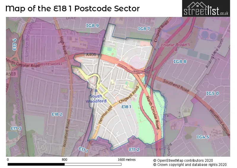
The E18 1 Postcode shares a border with IG8 8 (WOODFORD GREEN , CHIGWELL ), IG8 9 (WOODFORD GREEN ), E11 1 (LEYTONSTONE , WANSTEAD , LONDON ), E11 2 (WANSTEAD , LONDON ), E18 2 (SOUTH WOODFORD ), IG4 5 (ILFORD , GANTS HILL , CLAYHALL ) and IG8 7 (WOODFORD GREEN ).
The sector is within the post town of LONDON.
E18 1 is a postcode sector within the E18 postcode district which is within the E East London postcode area.
The Royal Mail delivery office for the E18 1 postal sector is the South Woodford Sdelivery Office.
The area of the E18 1 postcode sector is 0.54 square miles which is 1.41 square kilometres or 347.85 square acres.
The E18 1 postcode sector is crossed by the M11 motorway.
Waterways within the E18 1 postcode sector include the River Roding.

Map of the E18 1 Postcode Sector
Explore the E18 1 postcode sector by using our free interactive map.
| E | 1 | 8 | - | 1 | X | X |
| E | 1 | 8 | Space | 1 | Letter | Letter |
Official List of Streets
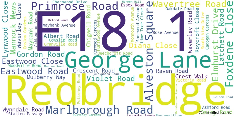
Redbridge (58 Streets)
Unofficial Streets or Alternative Spellings
Redbridge
CLEVELAND ROAD COLVIN GARDENS CRANBOURNE AVENUE FALCON WAYWOODFORD GREEN
SOUTHEND ROAD ADMIRALS CLOSE CHARLIE BROWNS ROUNDABOUT FOSTERS CLOSE GEORGE LANE ROUNDABOUT JUBILEE LODGE MARLBOROUGH BUSINESS CENTRE NORTH CIRCULAR ROAD OLD MILL COURT RODING VALLEY WAY SAINT BARNABAS ROAD SOUTHVIEW DRIVE ST BARNABAS ROAD STATION APPROACH THE SHRUBBERIES THE VIADUCTWeather Forecast for E18 1
Press Button to Show Forecast for Walthamstow
| Time Period | Icon | Description | Temperature | Rain Probability | Wind |
|---|---|---|---|---|---|
| 15:00 to 18:00 | Overcast | 12.0°C (feels like 11.0°C) | 8.00% | E 4 mph | |
| 18:00 to 21:00 | Overcast | 11.0°C (feels like 9.0°C) | 9.00% | E 9 mph | |
| 21:00 to 00:00 | Cloudy | 9.0°C (feels like 6.0°C) | 8.00% | E 9 mph |
Press Button to Show Forecast for Walthamstow
| Time Period | Icon | Description | Temperature | Rain Probability | Wind |
|---|---|---|---|---|---|
| 00:00 to 03:00 | Overcast | 8.0°C (feels like 5.0°C) | 17.00% | ENE 9 mph | |
| 03:00 to 06:00 | Heavy rain | 7.0°C (feels like 4.0°C) | 79.00% | NE 9 mph | |
| 06:00 to 09:00 | Light rain | 6.0°C (feels like 4.0°C) | 53.00% | NE 9 mph | |
| 09:00 to 12:00 | Overcast | 8.0°C (feels like 5.0°C) | 15.00% | NE 9 mph | |
| 12:00 to 15:00 | Cloudy | 11.0°C (feels like 9.0°C) | 13.00% | NE 7 mph | |
| 15:00 to 18:00 | Cloudy | 12.0°C (feels like 11.0°C) | 12.00% | ENE 7 mph | |
| 18:00 to 21:00 | Light rain | 12.0°C (feels like 10.0°C) | 56.00% | NE 9 mph | |
| 21:00 to 00:00 | Light rain | 10.0°C (feels like 8.0°C) | 67.00% | NE 9 mph |
Press Button to Show Forecast for Walthamstow
| Time Period | Icon | Description | Temperature | Rain Probability | Wind |
|---|---|---|---|---|---|
| 00:00 to 03:00 | Heavy rain | 9.0°C (feels like 6.0°C) | 89.00% | NNE 11 mph | |
| 03:00 to 06:00 | Heavy rain | 9.0°C (feels like 6.0°C) | 89.00% | NNE 9 mph | |
| 06:00 to 09:00 | Heavy rain | 9.0°C (feels like 7.0°C) | 87.00% | N 7 mph | |
| 09:00 to 12:00 | Light rain | 9.0°C (feels like 7.0°C) | 58.00% | WNW 9 mph | |
| 12:00 to 15:00 | Light rain | 10.0°C (feels like 7.0°C) | 54.00% | W 11 mph | |
| 15:00 to 18:00 | Overcast | 11.0°C (feels like 9.0°C) | 20.00% | W 11 mph | |
| 18:00 to 21:00 | Cloudy | 11.0°C (feels like 9.0°C) | 10.00% | W 9 mph | |
| 21:00 to 00:00 | Partly cloudy (night) | 9.0°C (feels like 8.0°C) | 5.00% | SW 7 mph |
Press Button to Show Forecast for Walthamstow
| Time Period | Icon | Description | Temperature | Rain Probability | Wind |
|---|---|---|---|---|---|
| 00:00 to 03:00 | Clear night | 8.0°C (feels like 7.0°C) | 2.00% | SW 4 mph | |
| 03:00 to 06:00 | Clear night | 7.0°C (feels like 5.0°C) | 1.00% | SSW 4 mph | |
| 06:00 to 09:00 | Sunny day | 7.0°C (feels like 6.0°C) | 1.00% | S 4 mph | |
| 09:00 to 12:00 | Sunny day | 12.0°C (feels like 10.0°C) | 1.00% | S 9 mph | |
| 12:00 to 15:00 | Cloudy | 14.0°C (feels like 12.0°C) | 8.00% | S 11 mph | |
| 15:00 to 18:00 | Partly cloudy (day) | 15.0°C (feels like 13.0°C) | 2.00% | S 11 mph | |
| 18:00 to 21:00 | Sunny day | 14.0°C (feels like 12.0°C) | 4.00% | S 9 mph | |
| 21:00 to 00:00 | Clear night | 11.0°C (feels like 10.0°C) | 1.00% | SSE 7 mph |
Press Button to Show Forecast for Walthamstow
| Time Period | Icon | Description | Temperature | Rain Probability | Wind |
|---|---|---|---|---|---|
| 00:00 to 03:00 | Clear night | 10.0°C (feels like 8.0°C) | 1.00% | SE 7 mph | |
| 03:00 to 06:00 | Clear night | 9.0°C (feels like 7.0°C) | 2.00% | ESE 7 mph | |
| 06:00 to 09:00 | Cloudy | 9.0°C (feels like 8.0°C) | 8.00% | ESE 7 mph | |
| 09:00 to 12:00 | Cloudy | 13.0°C (feels like 12.0°C) | 8.00% | ESE 7 mph | |
| 12:00 to 15:00 | Cloudy | 16.0°C (feels like 14.0°C) | 10.00% | SE 9 mph | |
| 15:00 to 18:00 | Cloudy | 17.0°C (feels like 15.0°C) | 12.00% | SE 9 mph | |
| 18:00 to 21:00 | Cloudy | 16.0°C (feels like 14.0°C) | 12.00% | SE 9 mph | |
| 21:00 to 00:00 | Cloudy | 13.0°C (feels like 12.0°C) | 16.00% | ESE 7 mph |
Schools and Places of Education Within the E18 1 Postcode Sector
Nightingale Primary School
Community school
Ashbourne Avenue, London, , E18 1PL
Head: Mrs Clare Lynam
Ofsted Rating: Good
Inspection: 2023-10-11 (198 days ago)
Website: Visit Nightingale Primary School Website
Phone: 02089899987
Number of Pupils: 712
Oakdale Infants' School
Community school
Woodville Road, London, , E18 1JU
Head: Mr Danvir Visvanathan
Ofsted Rating: Good
Inspection: 2023-09-21 (218 days ago)
Website: Visit Oakdale Infants' School Website
Phone: 02089897895
Number of Pupils: 313
Oakdale Junior School
Community school
Oakdale Road, London, , E18 1JX
Head: Mr Danvir Visvanathan
Ofsted Rating: Good
Inspection: 2019-07-10 (1752 days ago)
Website: Visit Oakdale Junior School Website
Phone: 02089897471
Number of Pupils: 338
House Prices in the E18 1 Postcode Sector
| Type of Property | 2018 Average | 2018 Sales | 2017 Average | 2017 Sales | 2016 Average | 2016 Sales | 2015 Average | 2015 Sales |
|---|---|---|---|---|---|---|---|---|
| Detached | £0 | 0 | £667,825 | 2 | £907,500 | 2 | £0 | 0 |
| Semi-Detached | £671,857 | 21 | £796,832 | 22 | £678,846 | 13 | £591,295 | 22 |
| Terraced | £647,501 | 46 | £620,884 | 54 | £582,520 | 50 | £541,611 | 48 |
| Flats | £334,155 | 46 | £348,029 | 33 | £352,615 | 39 | £289,752 | 54 |
Important Postcodes E18 1 in the Postcode Sector
E18 1AA is the postcode for Royal Mail, South Woodford Delivery Office, 49 Marlborough Road
E18 1JU is the postcode for Oakdale Infant School, Woodville Road
E18 1JX is the postcode for Oakdale Junior School, Oakdale Road, NEW BUILD, Oakdale Junior School, Oakdale Road, and MAIN BUILDING, Oakdale Junior School, Oakdale Road
E18 1PL is the postcode for Nightingale Primary School, Ashbourne Avenue
| The E18 1 Sector is within these Local Authorities |
|
|---|---|
| The E18 1 Sector is within these Counties |
|
| The E18 1 Sector is within these Water Company Areas |
|