The L13 1 postcode sector is within the county of Merseyside.
Did you know? According to the 2021 Census, the L13 1 postcode sector is home to a bustling 1,340 residents!
Given that each sector allows for 400 unique postcode combinations. Letters C, I, K, M, O and V are not allowed in the last two letters of a postcode. With 45 postcodes already in use, this leaves 355 units available.
The largest settlement in the L13 1 postal code is LIVERPOOL followed by Old Swan, and Wavertree.
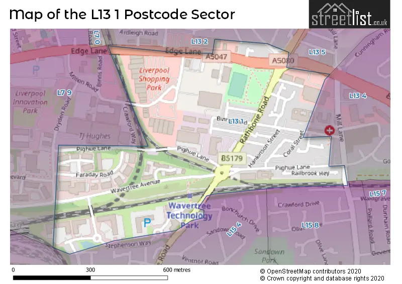
The L13 1 Postcode shares a border with L13 2 (LIVERPOOL, Old Swan, Stanley), L7 9 (LIVERPOOL, Fairfield, Edge Hill), L13 4 (LIVERPOOL, Old Swan, Stoneycroft), L13 5 (LIVERPOOL, Old Swan, Stoneycroft), L15 4 (LIVERPOOL, Wavertree) and L15 8 (LIVERPOOL, Wavertree).
The sector is within the post town of LIVERPOOL.
L13 1 is a postcode sector within the L13 postcode district which is within the L Liverpool postcode area.
The Royal Mail delivery office for the L13 1 postal sector is the South Eastern (l) Delivery Office.
The area of the L13 1 postcode sector is 0.22 square miles which is 0.56 square kilometres or 139.32 square acres.

Map of the L13 1 Postcode Sector
Explore the L13 1 postcode sector by using our free interactive map.
| L | 1 | 3 | - | 1 | X | X |
| L | 1 | 3 | Space | 1 | Letter | Letter |
Official List of Streets
Old Swan (6 Streets)
LIVERPOOL (21 Streets)
Wavertree (3 Streets)
Liverpool Shopping Park (1 Streets)
Unofficial Streets or Alternative Spellings
Old Swan
MILL LANELIVERPOOL
ALLENBY SQUARE ARDLEIGH ROAD DORIEN ROAD DRYDEN ROAD EDGE LANE DRIVE ELMS HOUSE ROAD FOXDELL CLOSE SHANKLIN ROAD WAVERTREE AVENUE WINCANTON STREET BORAX STREET CRAWFORD WAY GARNET STREET NEWTON COURT SAINT MARYS CLOSE ST OSWALDS STREET STEPHENSON ROADEdge Hill
EDGE LANEWeather Forecast for L13 1
Press Button to Show Forecast for Wavertree
| Time Period | Icon | Description | Temperature | Rain Probability | Wind |
|---|---|---|---|---|---|
| 03:00 to 06:00 | Partly cloudy (night) | 6.0°C (feels like 3.0°C) | 3.00% | ENE 7 mph | |
| 06:00 to 09:00 | Partly cloudy (day) | 5.0°C (feels like 3.0°C) | 2.00% | E 7 mph | |
| 09:00 to 12:00 | Cloudy | 8.0°C (feels like 6.0°C) | 5.00% | E 9 mph | |
| 12:00 to 15:00 | Overcast | 10.0°C (feels like 8.0°C) | 9.00% | E 9 mph | |
| 15:00 to 18:00 | Overcast | 10.0°C (feels like 8.0°C) | 46.00% | ENE 9 mph | |
| 18:00 to 21:00 | Overcast | 9.0°C (feels like 7.0°C) | 45.00% | NE 9 mph | |
| 21:00 to 00:00 | Cloudy | 8.0°C (feels like 6.0°C) | 5.00% | NE 9 mph |
Press Button to Show Forecast for Wavertree
| Time Period | Icon | Description | Temperature | Rain Probability | Wind |
|---|---|---|---|---|---|
| 00:00 to 03:00 | Partly cloudy (night) | 7.0°C (feels like 4.0°C) | 2.00% | NE 7 mph | |
| 03:00 to 06:00 | Cloudy | 6.0°C (feels like 3.0°C) | 4.00% | NNE 9 mph | |
| 06:00 to 09:00 | Cloudy | 6.0°C (feels like 3.0°C) | 8.00% | N 9 mph | |
| 09:00 to 12:00 | Cloudy | 8.0°C (feels like 5.0°C) | 10.00% | NNW 9 mph | |
| 12:00 to 15:00 | Cloudy | 9.0°C (feels like 7.0°C) | 12.00% | NW 11 mph | |
| 15:00 to 18:00 | Sunny day | 10.0°C (feels like 7.0°C) | 8.00% | WNW 13 mph | |
| 18:00 to 21:00 | Sunny day | 10.0°C (feels like 8.0°C) | 3.00% | W 11 mph | |
| 21:00 to 00:00 | Clear night | 9.0°C (feels like 6.0°C) | 2.00% | SW 11 mph |
Press Button to Show Forecast for Wavertree
| Time Period | Icon | Description | Temperature | Rain Probability | Wind |
|---|---|---|---|---|---|
| 00:00 to 03:00 | Clear night | 8.0°C (feels like 5.0°C) | 1.00% | SSW 9 mph | |
| 03:00 to 06:00 | Cloudy | 7.0°C (feels like 4.0°C) | 5.00% | S 11 mph | |
| 06:00 to 09:00 | Cloudy | 7.0°C (feels like 3.0°C) | 7.00% | SSE 11 mph | |
| 09:00 to 12:00 | Partly cloudy (day) | 10.0°C (feels like 7.0°C) | 2.00% | SSE 13 mph | |
| 12:00 to 15:00 | Overcast | 13.0°C (feels like 10.0°C) | 10.00% | S 16 mph | |
| 15:00 to 18:00 | Cloudy | 13.0°C (feels like 10.0°C) | 9.00% | S 16 mph | |
| 18:00 to 21:00 | Cloudy | 13.0°C (feels like 10.0°C) | 8.00% | SSE 16 mph | |
| 21:00 to 00:00 | Partly cloudy (night) | 11.0°C (feels like 8.0°C) | 3.00% | SSE 13 mph |
Press Button to Show Forecast for Wavertree
| Time Period | Icon | Description | Temperature | Rain Probability | Wind |
|---|---|---|---|---|---|
| 00:00 to 03:00 | Partly cloudy (night) | 10.0°C (feels like 7.0°C) | 4.00% | SE 13 mph | |
| 03:00 to 06:00 | Cloudy | 9.0°C (feels like 6.0°C) | 6.00% | SE 13 mph | |
| 06:00 to 09:00 | Cloudy | 9.0°C (feels like 6.0°C) | 6.00% | SE 13 mph | |
| 09:00 to 12:00 | Cloudy | 12.0°C (feels like 9.0°C) | 7.00% | SE 13 mph | |
| 12:00 to 15:00 | Partly cloudy (day) | 15.0°C (feels like 11.0°C) | 5.00% | SE 16 mph | |
| 15:00 to 18:00 | Cloudy | 16.0°C (feels like 13.0°C) | 14.00% | SE 13 mph | |
| 18:00 to 21:00 | Partly cloudy (day) | 15.0°C (feels like 13.0°C) | 6.00% | SE 11 mph | |
| 21:00 to 00:00 | Cloudy | 13.0°C (feels like 11.0°C) | 8.00% | E 9 mph |
Schools and Places of Education Within the L13 1 Postcode Sector
King's Leadership Phoenix Academy
Free schools alternative provision
4 Enterprise Way, Liverpool, Merseyside, L13 1FB
Head: Mr Danny Cross
Ofsted Rating: Requires improvement
Inspection: 2022-09-22 (583 days ago)
Website: Visit King's Leadership Phoenix Academy Website
Phone: 01512454968
Number of Pupils: 3
Nazene Danielle School of Performing Arts
Other independent school
3 Newton Court, Liverpool, , L13 1EJ
Head: Mrs Nazene Langfield
Ofsted Rating: Good
Inspection: 2022-12-01 (513 days ago)
Website: Visit Nazene Danielle School of Performing Arts Website
Phone: 07701049837
Number of Pupils: 12
House Prices in the L13 1 Postcode Sector
| Type of Property | 2018 Average | 2018 Sales | 2017 Average | 2017 Sales | 2016 Average | 2016 Sales | 2015 Average | 2015 Sales |
|---|---|---|---|---|---|---|---|---|
| Detached | £150,000 | 1 | £0 | 0 | £0 | 0 | £140,000 | 1 |
| Semi-Detached | £110,000 | 1 | £105,333 | 3 | £178,000 | 5 | £95,000 | 2 |
| Terraced | £88,351 | 15 | £74,625 | 12 | £61,909 | 11 | £69,136 | 11 |
| Flats | £64,333 | 3 | £0 | 0 | £53,250 | 3 | £55,000 | 1 |
Important Postcodes L13 1 in the Postcode Sector
L13 1EH is the postcode for Northwest Development Agency, 18-24 Faraday Road
L13 1FB is the postcode for Liverpool Community Health, Wilkinson Place, 2 Enterprise Way, and Studio Deyes, 3000 Vortex Court, Enterprise Way
L13 1HN is the postcode for Merseyside Care NHS Trust, Bevan House, 65 Stephenson Way, and NHS Central Operations Mersey, Bevan House, 65 Stephenson Way
| The L13 1 Sector is within these Local Authorities |
|
|---|---|
| The L13 1 Sector is within these Counties |
|
| The L13 1 Sector is within these Water Company Areas |
|