The M25 3 postcode sector is within the county of Greater Manchester.
Did you know? According to the 2021 Census, the M25 3 postcode sector is home to a bustling 3,894 residents!
Given that each sector allows for 400 unique postcode combinations. Letters C, I, K, M, O and V are not allowed in the last two letters of a postcode. With 110 postcodes already in use, this leaves 290 units available.
The M25 3 postal code covers the settlement of Prestwich.
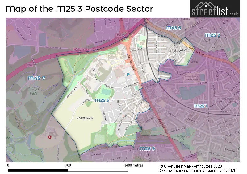
The M25 3 Postcode shares a border with M25 9 (Prestwich), M25 1 (Prestwich), M25 2 (Prestwich), M45 6 (Whitefield) and M45 7 (Whitefield).
The sector is within the post town of MANCHESTER.
M25 3 is a postcode sector within the M25 postcode district which is within the M Manchester postcode area.
The Royal Mail delivery office for the M25 3 postal sector is the Prestwich Delivery Office.
The area of the M25 3 postcode sector is 0.52 square miles which is 1.35 square kilometres or 332.42 square acres.
The M25 3 postcode sector is crossed by the M60 motorway.

Map of the M25 3 Postcode Sector
Explore the M25 3 postcode sector by using our free interactive map.
| M | 2 | 5 | - | 3 | X | X |
| M | 2 | 5 | Space | 3 | Letter | Letter |
Official List of Streets
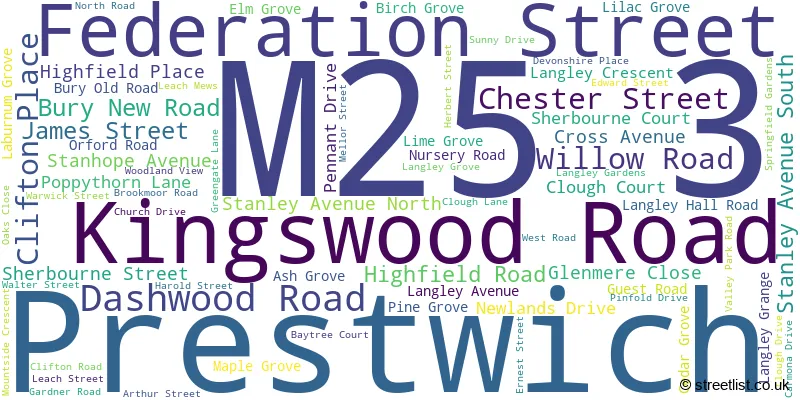
Prestwich (69 Streets)
Unofficial Streets or Alternative Spellings
Weather Forecast for M25 3
Press Button to Show Forecast for Prestwich
| Time Period | Icon | Description | Temperature | Rain Probability | Wind |
|---|---|---|---|---|---|
| 03:00 to 06:00 | Partly cloudy (night) | 4.0°C (feels like 2.0°C) | 1.00% | NE 7 mph | |
| 06:00 to 09:00 | Partly cloudy (day) | 4.0°C (feels like 2.0°C) | 2.00% | NE 7 mph | |
| 09:00 to 12:00 | Cloudy | 8.0°C (feels like 5.0°C) | 6.00% | ENE 9 mph | |
| 12:00 to 15:00 | Overcast | 10.0°C (feels like 7.0°C) | 8.00% | ENE 9 mph | |
| 15:00 to 18:00 | Light rain | 9.0°C (feels like 7.0°C) | 46.00% | ENE 9 mph | |
| 18:00 to 21:00 | Cloudy | 9.0°C (feels like 6.0°C) | 14.00% | ENE 9 mph | |
| 21:00 to 00:00 | Cloudy | 7.0°C (feels like 5.0°C) | 5.00% | NE 9 mph |
Press Button to Show Forecast for Prestwich
| Time Period | Icon | Description | Temperature | Rain Probability | Wind |
|---|---|---|---|---|---|
| 00:00 to 03:00 | Cloudy | 6.0°C (feels like 3.0°C) | 4.00% | NE 7 mph | |
| 03:00 to 06:00 | Cloudy | 5.0°C (feels like 3.0°C) | 6.00% | NNE 7 mph | |
| 06:00 to 09:00 | Cloudy | 6.0°C (feels like 3.0°C) | 13.00% | N 7 mph | |
| 09:00 to 12:00 | Cloudy | 7.0°C (feels like 5.0°C) | 16.00% | NNW 7 mph | |
| 12:00 to 15:00 | Light rain | 9.0°C (feels like 7.0°C) | 46.00% | NW 9 mph | |
| 15:00 to 18:00 | Cloudy | 10.0°C (feels like 8.0°C) | 14.00% | WNW 11 mph | |
| 18:00 to 21:00 | Partly cloudy (day) | 10.0°C (feels like 8.0°C) | 5.00% | W 9 mph | |
| 21:00 to 00:00 | Clear night | 8.0°C (feels like 6.0°C) | 3.00% | WSW 7 mph |
Press Button to Show Forecast for Prestwich
| Time Period | Icon | Description | Temperature | Rain Probability | Wind |
|---|---|---|---|---|---|
| 00:00 to 03:00 | Partly cloudy (night) | 6.0°C (feels like 4.0°C) | 2.00% | SSW 7 mph | |
| 03:00 to 06:00 | Clear night | 5.0°C (feels like 3.0°C) | 3.00% | SSE 7 mph | |
| 06:00 to 09:00 | Partly cloudy (day) | 6.0°C (feels like 3.0°C) | 4.00% | SSE 7 mph | |
| 09:00 to 12:00 | Partly cloudy (day) | 10.0°C (feels like 7.0°C) | 3.00% | S 11 mph | |
| 12:00 to 15:00 | Cloudy | 13.0°C (feels like 10.0°C) | 8.00% | S 13 mph | |
| 15:00 to 18:00 | Cloudy | 13.0°C (feels like 11.0°C) | 9.00% | S 13 mph | |
| 18:00 to 21:00 | Partly cloudy (day) | 13.0°C (feels like 11.0°C) | 8.00% | S 11 mph | |
| 21:00 to 00:00 | Clear night | 11.0°C (feels like 9.0°C) | 5.00% | SSE 9 mph |
Press Button to Show Forecast for Prestwich
| Time Period | Icon | Description | Temperature | Rain Probability | Wind |
|---|---|---|---|---|---|
| 00:00 to 03:00 | Clear night | 9.0°C (feels like 7.0°C) | 4.00% | SE 9 mph | |
| 03:00 to 06:00 | Partly cloudy (night) | 8.0°C (feels like 6.0°C) | 3.00% | SE 9 mph | |
| 06:00 to 09:00 | Sunny day | 9.0°C (feels like 6.0°C) | 3.00% | ESE 9 mph | |
| 09:00 to 12:00 | Partly cloudy (day) | 12.0°C (feels like 10.0°C) | 5.00% | ESE 11 mph | |
| 12:00 to 15:00 | Cloudy | 15.0°C (feels like 12.0°C) | 8.00% | SE 13 mph | |
| 15:00 to 18:00 | Cloudy | 16.0°C (feels like 13.0°C) | 11.00% | SE 11 mph | |
| 18:00 to 21:00 | Partly cloudy (day) | 15.0°C (feels like 13.0°C) | 7.00% | ESE 11 mph | |
| 21:00 to 00:00 | Cloudy | 13.0°C (feels like 11.0°C) | 8.00% | E 9 mph |
Schools and Places of Education Within the M25 3 Postcode Sector
Cloughside College
Community special school
Bury New Road, Manchester, , M25 3BL
Head: Mrs Karen Ingham
Ofsted Rating: Good
Inspection: 2018-07-17 (2111 days ago)
Website: Visit Cloughside College Website
Phone: 01612710106
Number of Pupils: 11
Our Lady of Grace RC Primary School
Voluntary aided school
Highfield Road, Manchester, Lancashire, M25 3AS
Head: Mrs A K Casey
Ofsted Rating: Good
Inspection: 2023-03-14 (410 days ago)
Website: Visit Our Lady of Grace RC Primary School Website
Phone: 01617967254
Number of Pupils: 320
House Prices in the M25 3 Postcode Sector
| Type of Property | 2018 Average | 2018 Sales | 2017 Average | 2017 Sales | 2016 Average | 2016 Sales | 2015 Average | 2015 Sales |
|---|---|---|---|---|---|---|---|---|
| Detached | £410,085 | 14 | £353,062 | 30 | £319,368 | 8 | £262,117 | 6 |
| Semi-Detached | £245,529 | 35 | £273,858 | 25 | £212,105 | 55 | £205,843 | 48 |
| Terraced | £196,213 | 28 | £184,236 | 34 | £184,863 | 28 | £172,873 | 34 |
| Flats | £196,040 | 23 | £112,250 | 4 | £114,500 | 10 | £91,541 | 17 |
Important Postcodes M25 3 in the Postcode Sector
M25 3AA is the postcode for Royal Mail, Prestwich Delivery Office, 2 Kingswood Road
M25 3AS is the postcode for EARLY YEARS CENTRE, Our Lady of Grace RC Primary School, Highfield Road, Our Lady of Grace RC Primary School, Highfield Road, Prestwich, and Our Lady of Grace RC Primary School, Highfield Road
M25 3BL is the postcode for HARROP HOUSE, GREATER MANCHESTER MENTAL HEALTH NHS FOUNDATION TRUST, BURY NEW ROAD, JULIA CHAPMAN BARKER UNIT, GREATER MANCHESTER MENTAL HEALTH NHS FOUNDATION TRUST, BURY NEW ROAD, KNOWSLEY BUILDING, Greater Manchester West NHS Foundation Trust, Bury New Road, OAKWOOD (IM&T), Greater Manchester Mental Health NHS Foundation Trust, Bury New Road, MCGUINESS UNIT, Greater Manchester Mental Health NHS Foundation Trust, Bury New Road, GARDNER UNIT, Greater Manchester Mental Health NHS Foundation Trust, Bury New Road, IVY HOUSE, Greater Manchester Mental Health NHS Foundation Trust, Bury New Road, Greater Manchester West Mental Health NHS Foundation Trust, Prestwich Hospital, JUNCTION 17, Greater Manchester Mental Health NHS Foundation Trust, Bury New Road, K BLOCK, Greater Manchester Mental Health NHS Foundation Trust, Bury New Road, LOWESWATER WARD, Greater Manchester Mental Health NHS Foundation Trust, Bury New Road, WATERDALE, Greater Manchester Mental Health NHS Foundation Trust, Bury New Road, KENYON HOUSE, Greater Manchester Mental Health NHS Foundation Trust, Bury New Road, IVY HOUSE, Greater Manchester West NHS Foundation Trust, Bury New Road, ESKDALE, RYDAL, DOVEDALE WARDS & EDENFIELD CENTRE, GREATER MANCHESTER MENTAL HEALTH NHS FOUNDATION TRUST, BURY NEW ROAD, LOWESWATER WARD, Greater Manchester West NHS Foundation Trust, Bury New Road, CREATIVE LIVING CENTRE, Greater Manchester Mental Health NHS Foundation Trust, Bury New Road, RECEIPT AND DISTRIBUTION SERVICES, Greater Manchester Mental Health NHS Foundation Trust, Bury New Road, ESKDALE/RYDAL/DOVEDALE WARDS EDENFIELD CENTRE, Greater Manchester Mental Health NHS Foundation Trust, Prestwich Hospital, Bury New Road, EDENFIELD, GREATER MANCHESTER MENTAL HEALTH NHS FOUNDATION TRUST, BURY NEW ROAD, KNOWSLEY BUILDING, Greater Manchester Mental Health NHS Foundation Trust, Bury New Road, EDENFIELD SPORTS HALL, Greater Manchester Mental Health NHS Foundation Trust, Prestwich Hospital, Bury New Road, NEWLAND, Greater Manchester Mental Health NHS Foundation Trust, Bury New Road, JOHN DENMARK UNIT, Greater Manchester Mental Health NHS Foundation Trust, Bury New Road, and PATTERDALE, Greater Manchester Mental Health NHS Foundation Trust, Bury New Road
M25 3JG is the postcode for 203, Clifton Road, Prestwich
| The M25 3 Sector is within these Local Authorities |
|
|---|---|
| The M25 3 Sector is within these Counties |
|
| The M25 3 Sector is within these Water Company Areas |
|