The NG10 4 postcode sector is within the county of Derbyshire.
Did you know? According to the 2021 Census, the NG10 4 postcode sector is home to a bustling 10,660 residents!
Given that each sector allows for 400 unique postcode combinations. Letters C, I, K, M, O and V are not allowed in the last two letters of a postcode. With 216 postcodes already in use, this leaves 184 units available.
The NG10 4 postal code covers the settlement of Long Eaton.
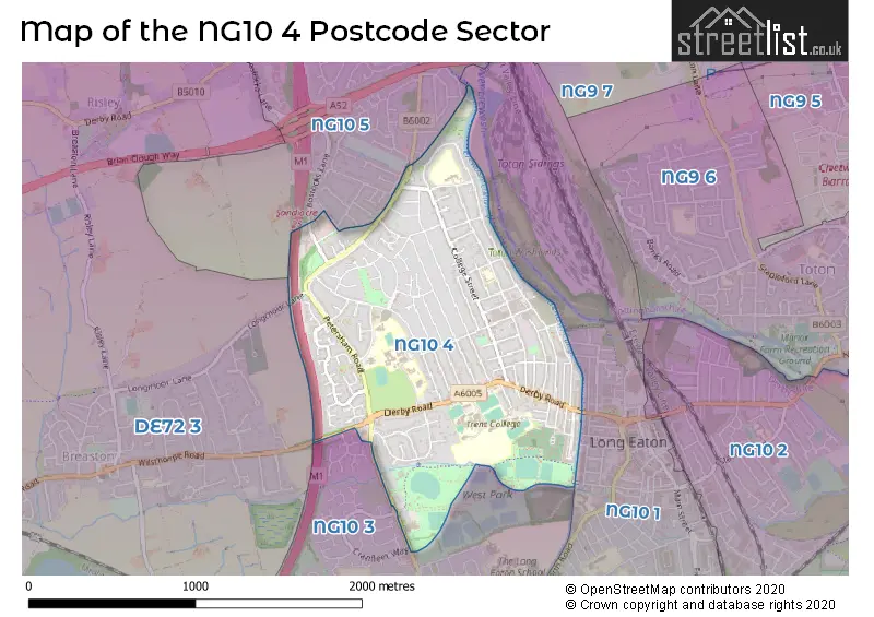
The NG10 4 Postcode shares a border with NG10 1 (Long Eaton), NG10 3 (Long Eaton), NG10 5 (Sandiacre) and DE72 3 (Borrowash, Breaston, Draycott).
The sector is within the post town of NOTTINGHAM.
NG10 4 is a postcode sector within the NG10 postcode district which is within the NG Nottingham postcode area.
The Royal Mail delivery office for the NG10 4 postal sector is the Long Eaton Delivery Office.
The area of the NG10 4 postcode sector is 1.03 square miles which is 2.67 square kilometres or 660.67 square acres.
The NG10 4 postcode sector is crossed by the M1 motorway.
Waterways within the NG10 4 postcode sector include the Erewash Canal.

Map of the NG10 4 Postcode Sector
Explore the NG10 4 postcode sector by using our free interactive map.
| N | G | 1 | 0 | - | 4 | X | X |
| N | G | 1 | 0 | Space | 4 | Letter | Letter |
Official List of Streets
Long Eaton (104 Streets)
Unofficial Streets or Alternative Spellings
Long Eaton
CRANFLEET WAY PARKLAND MEWSBreaston
LONGMOOR LANESandiacre
LOCK LANE LONGMOOR LANE SPRINGFIELD AVENUEWeather Forecast for NG10 4
Press Button to Show Forecast for Long Eaton
| Time Period | Icon | Description | Temperature | Rain Probability | Wind |
|---|---|---|---|---|---|
| 09:00 to 12:00 | Cloudy | 7.0°C (feels like 5.0°C) | 4.00% | ENE 7 mph | |
| 12:00 to 15:00 | Cloudy | 9.0°C (feels like 9.0°C) | 9.00% | ENE 4 mph | |
| 15:00 to 18:00 | Cloudy | 10.0°C (feels like 8.0°C) | 8.00% | ENE 4 mph | |
| 18:00 to 21:00 | Cloudy | 8.0°C (feels like 6.0°C) | 11.00% | ENE 9 mph | |
| 21:00 to 00:00 | Cloudy | 6.0°C (feels like 4.0°C) | 10.00% | ENE 7 mph |
Press Button to Show Forecast for Long Eaton
| Time Period | Icon | Description | Temperature | Rain Probability | Wind |
|---|---|---|---|---|---|
| 00:00 to 03:00 | Partly cloudy (night) | 5.0°C (feels like 3.0°C) | 8.00% | NE 4 mph | |
| 03:00 to 06:00 | Cloudy | 4.0°C (feels like 2.0°C) | 11.00% | NE 7 mph | |
| 06:00 to 09:00 | Cloudy | 4.0°C (feels like 2.0°C) | 10.00% | NE 7 mph | |
| 09:00 to 12:00 | Cloudy | 8.0°C (feels like 6.0°C) | 12.00% | ENE 9 mph | |
| 12:00 to 15:00 | Overcast | 10.0°C (feels like 7.0°C) | 21.00% | ENE 9 mph | |
| 15:00 to 18:00 | Overcast | 11.0°C (feels like 8.0°C) | 21.00% | ENE 11 mph | |
| 18:00 to 21:00 | Cloudy | 10.0°C (feels like 7.0°C) | 19.00% | ENE 11 mph | |
| 21:00 to 00:00 | Cloudy | 8.0°C (feels like 5.0°C) | 15.00% | NE 11 mph |
Press Button to Show Forecast for Long Eaton
| Time Period | Icon | Description | Temperature | Rain Probability | Wind |
|---|---|---|---|---|---|
| 00:00 to 03:00 | Cloudy | 7.0°C (feels like 4.0°C) | 20.00% | NE 11 mph | |
| 03:00 to 06:00 | Light rain | 7.0°C (feels like 4.0°C) | 52.00% | NNE 13 mph | |
| 06:00 to 09:00 | Heavy rain | 7.0°C (feels like 4.0°C) | 77.00% | NNE 13 mph | |
| 09:00 to 12:00 | Heavy rain | 9.0°C (feels like 6.0°C) | 78.00% | NE 13 mph | |
| 12:00 to 15:00 | Heavy rain | 10.0°C (feels like 7.0°C) | 77.00% | N 13 mph | |
| 15:00 to 18:00 | Light rain shower (day) | 10.0°C (feels like 8.0°C) | 42.00% | N 11 mph | |
| 18:00 to 21:00 | Light rain | 10.0°C (feels like 8.0°C) | 50.00% | NNE 9 mph | |
| 21:00 to 00:00 | Cloudy | 8.0°C (feels like 7.0°C) | 11.00% | SW 7 mph |
Schools and Places of Education Within the NG10 4 Postcode Sector
Brackenfield Special School
Community special school
Bracken Road, Nottingham, Derbyshire, NG10 4DA
Head: Mrs Trish Turner
Ofsted Rating: Good
Inspection: 2023-06-29 (302 days ago)
Website: Visit Brackenfield Special School Website
Phone: 01159733710
Number of Pupils: 161
English Martyrs' Catholic Voluntary Academy
Academy converter
Bracken Road, Nottingham, Nottinghamshire, NG10 4DA
Head: Mrs Gemma Ellis
Ofsted Rating: Requires improvement
Inspection: 2023-11-15 (163 days ago)
Website: Visit English Martyrs' Catholic Voluntary Academy Website
Phone: 01159733209
Number of Pupils: 267
Harrington Junior School
Community school
Derby Road, Nottingham, , NG10 4BJ
Head: Mrs Rachael Wilmot
Ofsted Rating: Good
Inspection: 2022-10-12 (562 days ago)
Website: Visit Harrington Junior School Website
Phone: 01156482089
Number of Pupils: 232
Longmoor Primary School
Community school
Newstead Road, Nottingham, Nottinghamshire, NG10 4JG
Head: Mrs Susan Dainty
Ofsted Rating: Good
Inspection: 2021-10-20 (919 days ago)
Website: Visit Longmoor Primary School Website
Phone: 01159733368
Number of Pupils: 425
Parklands Infant and Nursery School
Community school
Derby Road, Nottingham, Nottinghamshire, NG10 4BJ
Head: Mrs Karen Callaghan
Ofsted Rating: Good
Inspection: 2020-01-15 (1563 days ago)
Website: Visit Parklands Infant and Nursery School Website
Phone: 01159732667
Number of Pupils: 212
Wilsthorpe School
Academy converter
Derby Road, Nottingham, Nottinghamshire, NG10 4WT
Head: Mr Derek Hobbs
Ofsted Rating: Good
Inspection: 2023-05-11 (351 days ago)
Website: Visit Wilsthorpe School Website
Phone: 01159729421
Number of Pupils: 1192
House Prices in the NG10 4 Postcode Sector
| Type of Property | 2018 Average | 2018 Sales | 2017 Average | 2017 Sales | 2016 Average | 2016 Sales | 2015 Average | 2015 Sales |
|---|---|---|---|---|---|---|---|---|
| Detached | £296,338 | 39 | £267,740 | 51 | £269,156 | 45 | £228,788 | 52 |
| Semi-Detached | £153,552 | 112 | £149,020 | 107 | £144,947 | 110 | £124,593 | 119 |
| Terraced | £116,968 | 51 | £109,069 | 61 | £108,234 | 54 | £100,098 | 43 |
| Flats | £72,333 | 3 | £83,833 | 3 | £119,250 | 2 | £71,625 | 2 |
Important Postcodes NG10 4 in the Postcode Sector
NG10 4AA is the postcode for WEST PARK CHANGING ROOMS, West Park Leisure Centre, Wilsthorpe Road, West Park Leisure Centre, Wilsthorpe Road, and West Park Leisure Centre, Wilsthorpe Road, Long Eaton
NG10 4BJ is the postcode for Parklands Infant & Nursery School, Derby Road, Parklands Infant & Nursery School, Wilsthorpe Campus, Derby Road, and Harrington Junior School, Derby Road
NG10 4BQ is the postcode for Whole Building, Outlook, 99 Briar Gate, and Outlook, 99 Briar Gate
NG10 4DA is the postcode for English Martyrs' Catholic Voluntary Academy, Bracken Road, Long Eaton, English Martyrs' Catholic Voluntary Academy, Bracken Road, Main Building, Brackenfield School & Specialist College of Cognition & Learning, Brackenfield Road, Main Building, Brackenfield School & Specialist College of Cognitive & Learning, Brackenfield Road, and Brackenfield School & Specialist College of Cognition & Learning, Bracken Road
NG10 4DD is the postcode for Petersham Centre, 58-60 Petersham Road
NG10 4JG is the postcode for Longmoor Primary School, Newstead Road, and MAIN BUILDING, Longmoor Primary School, Newstead Road
NG10 4LF is the postcode for Long Eaton Childrens Centre, Lime Terrace
NG10 4LL is the postcode for BLOCK 01, Community House, 173 Derby Road
NG10 4LP is the postcode for Glenholme Family Centre, 7 Dove Lane
NG10 4NP is the postcode for College Street Medical Practice, 86 College Street
NG10 4WT is the postcode for BLOCK 2, Wilsthorpe School, Derby Road, BLOCK 1, Wilsthorpe School, Derby Road, Wilsthorpe School, Derby Road, and Wilsthorpe School, Derby Road, Long Eaton
| The NG10 4 Sector is within these Local Authorities |
|
|---|---|
| The NG10 4 Sector is within these Counties |
|
| The NG10 4 Sector is within these Water Company Areas |
|