The SG11 2 postcode sector stands on the Essex and Hertfordshire border.
Did you know? According to the 2021 Census, the SG11 2 postcode sector is home to a bustling 3,039 residents!
Given that each sector allows for 400 unique postcode combinations. Letters C, I, K, M, O and V are not allowed in the last two letters of a postcode. With 168 postcodes already in use, this leaves 232 units available.
The largest settlement in the SG11 2 postal code is Little Hadham followed by Braughing, and Albury.
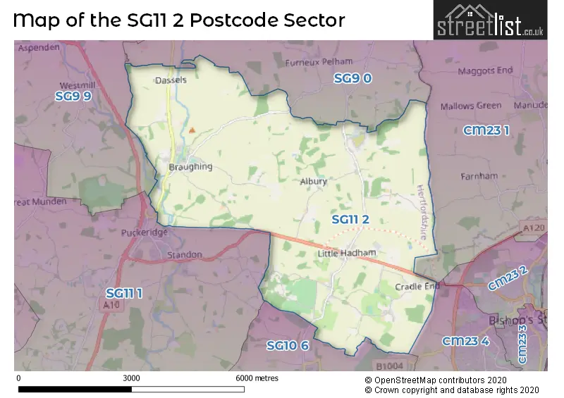
The SG11 2 Postcode shares a border with SG9 9 (BUNTINGFORD, Cottered, Westmill), SG10 6 (MUCH HADHAM), SG11 1 (Puckeridge, Standon, High Cross), CM23 1 (BISHOP'S STORTFORD, Manuden, Farnham), CM23 4 (BISHOP'S STORTFORD, Thorley, Spellbrook) and SG9 0 (Sandon, Furneux Pelham, Rushden).
The sector is within the post town of WARE.
SG11 2 is a postcode sector within the SG11 postcode district which is within the SG Stevenage postcode area.
The Royal Mail delivery office for the SG11 2 postal sector is the Ware Delivery Office.
The area of the SG11 2 postcode sector is 15.17 square miles which is 39.30 square kilometres or 9,711.66 square acres.

Map of the SG11 2 Postcode Sector
Explore the SG11 2 postcode sector by using our free interactive map.
| S | G | 1 | 1 | - | 2 | X | X |
| S | G | 1 | 1 | Space | 2 | Letter | Letter |
Official List of Streets
Little Hadham (25 Streets)
Albury (12 Streets)
Braughing (27 Streets)
Unofficial Streets or Alternative Spellings
BISHOP'S STORTFORD
HADHAM ROAD BARNCROFT BAUD CLOSE BOZEN GREEN LANE COOPERS YARD COW PASTURE PATH FLEECE LANE GRAVELLY DELL GREEN HILL HAY LANE HIGH HALL ROAD HIGHFIELDS HOARES LANE HOBBS LANE HOECROFT LANE HORSE CROSS HUMPSTEAD IDEAL FARM ITCH LANE LITTLE HADHAM BYPASS LLOYD-TAYLOR CLOSE LOWER ROAD MILL MOUND BRIDGE ROSE MEADOW STORTFORD LANE THE AVENUE THE BOURNE (ALBURY ROAD) THE CAUSEWAY THE IRON BRIDGE TILEKILN ROUNDABOUT VICARAGE LANE WATTS CLOSEFurneux Pelham
THE CAUSEWAYWeather Forecast for SG11 2
Press Button to Show Forecast for Dane End
| Time Period | Icon | Description | Temperature | Rain Probability | Wind |
|---|---|---|---|---|---|
| 15:00 to 18:00 | Cloudy | 11.0°C (feels like 9.0°C) | 5.00% | NE 7 mph | |
| 18:00 to 21:00 | Cloudy | 10.0°C (feels like 8.0°C) | 5.00% | ESE 9 mph | |
| 21:00 to 00:00 | Cloudy | 6.0°C (feels like 4.0°C) | 10.00% | E 7 mph |
Press Button to Show Forecast for Dane End
| Time Period | Icon | Description | Temperature | Rain Probability | Wind |
|---|---|---|---|---|---|
| 00:00 to 03:00 | Cloudy | 6.0°C (feels like 3.0°C) | 14.00% | ENE 9 mph | |
| 03:00 to 06:00 | Light rain | 6.0°C (feels like 3.0°C) | 49.00% | NE 9 mph | |
| 06:00 to 09:00 | Light rain | 6.0°C (feels like 3.0°C) | 51.00% | NE 9 mph | |
| 09:00 to 12:00 | Light rain | 7.0°C (feels like 4.0°C) | 49.00% | NE 11 mph | |
| 12:00 to 15:00 | Overcast | 9.0°C (feels like 7.0°C) | 16.00% | ENE 11 mph | |
| 15:00 to 18:00 | Cloudy | 11.0°C (feels like 9.0°C) | 13.00% | NE 9 mph | |
| 18:00 to 21:00 | Cloudy | 10.0°C (feels like 7.0°C) | 21.00% | NE 11 mph | |
| 21:00 to 00:00 | Light rain | 8.0°C (feels like 6.0°C) | 59.00% | NE 11 mph |
Press Button to Show Forecast for Dane End
| Time Period | Icon | Description | Temperature | Rain Probability | Wind |
|---|---|---|---|---|---|
| 00:00 to 03:00 | Heavy rain | 8.0°C (feels like 5.0°C) | 87.00% | NNE 11 mph | |
| 03:00 to 06:00 | Heavy rain | 8.0°C (feels like 5.0°C) | 90.00% | NNE 11 mph | |
| 06:00 to 09:00 | Heavy rain | 8.0°C (feels like 6.0°C) | 86.00% | NE 9 mph | |
| 09:00 to 12:00 | Heavy rain | 9.0°C (feels like 7.0°C) | 82.00% | WNW 9 mph | |
| 12:00 to 15:00 | Light rain | 9.0°C (feels like 6.0°C) | 59.00% | NW 13 mph | |
| 15:00 to 18:00 | Light rain | 10.0°C (feels like 7.0°C) | 50.00% | NW 11 mph | |
| 18:00 to 21:00 | Cloudy | 10.0°C (feels like 8.0°C) | 8.00% | WNW 7 mph | |
| 21:00 to 00:00 | Cloudy | 8.0°C (feels like 6.0°C) | 5.00% | SW 7 mph |
Press Button to Show Forecast for Dane End
| Time Period | Icon | Description | Temperature | Rain Probability | Wind |
|---|---|---|---|---|---|
| 00:00 to 03:00 | Partly cloudy (night) | 7.0°C (feels like 5.0°C) | 3.00% | SW 7 mph | |
| 03:00 to 06:00 | Clear night | 5.0°C (feels like 3.0°C) | 2.00% | SSW 4 mph | |
| 06:00 to 09:00 | Sunny day | 7.0°C (feels like 5.0°C) | 1.00% | S 4 mph | |
| 09:00 to 12:00 | Partly cloudy (day) | 11.0°C (feels like 9.0°C) | 1.00% | S 9 mph | |
| 12:00 to 15:00 | Partly cloudy (day) | 14.0°C (feels like 11.0°C) | 4.00% | S 11 mph | |
| 15:00 to 18:00 | Cloudy | 15.0°C (feels like 12.0°C) | 5.00% | S 11 mph | |
| 18:00 to 21:00 | Partly cloudy (day) | 13.0°C (feels like 11.0°C) | 1.00% | SSE 9 mph | |
| 21:00 to 00:00 | Clear night | 9.0°C (feels like 7.0°C) | 1.00% | SE 7 mph |
Press Button to Show Forecast for Dane End
| Time Period | Icon | Description | Temperature | Rain Probability | Wind |
|---|---|---|---|---|---|
| 00:00 to 03:00 | Clear night | 8.0°C (feels like 6.0°C) | 1.00% | ESE 7 mph | |
| 03:00 to 06:00 | Clear night | 8.0°C (feels like 6.0°C) | 4.00% | ESE 7 mph | |
| 06:00 to 09:00 | Partly cloudy (day) | 9.0°C (feels like 7.0°C) | 6.00% | ESE 7 mph | |
| 09:00 to 12:00 | Cloudy | 13.0°C (feels like 11.0°C) | 7.00% | SE 9 mph | |
| 12:00 to 15:00 | Cloudy | 15.0°C (feels like 13.0°C) | 10.00% | SE 9 mph | |
| 15:00 to 18:00 | Cloudy | 16.0°C (feels like 14.0°C) | 13.00% | SE 9 mph | |
| 18:00 to 21:00 | Cloudy | 14.0°C (feels like 13.0°C) | 13.00% | ESE 9 mph | |
| 21:00 to 00:00 | Cloudy | 11.0°C (feels like 10.0°C) | 10.00% | ESE 7 mph |
Schools and Places of Education Within the SG11 2 Postcode Sector
Albury Church of England Voluntary Aided Primary School
Voluntary aided school
Church End, Albury, Hertfordshire, SG11 2JQ
Head: Mrs Samantha Squires
Ofsted Rating: Good
Inspection: 2023-06-13 (318 days ago)
Website: Visit Albury Church of England Voluntary Aided Primary School Website
Phone: 01279771253
Number of Pupils: 61
Jenyns First School and Nursery
Community school
Uplands, Ware, Hertfordshire, SG11 2QJ
Head: Mrs Judy King
Ofsted Rating: Outstanding
Inspection: 2023-02-28 (423 days ago)
Website: Visit Jenyns First School and Nursery Website
Phone: 01920821461
Number of Pupils: 74
Little Hadham Primary School
Community school
Stortford Road, Ware, Hertfordshire, SG11 2DX
Head: Ms Sinead Connolly
Ofsted Rating: Good
Inspection: 2023-12-13 (135 days ago)
Website: Visit Little Hadham Primary School Website
Phone: 01279771285
Number of Pupils: 125
House Prices in the SG11 2 Postcode Sector
| Type of Property | 2018 Average | 2018 Sales | 2017 Average | 2017 Sales | 2016 Average | 2016 Sales | 2015 Average | 2015 Sales |
|---|---|---|---|---|---|---|---|---|
| Detached | £735,441 | 17 | £784,545 | 11 | £780,250 | 18 | £816,763 | 19 |
| Semi-Detached | £423,667 | 6 | £474,200 | 15 | £389,179 | 7 | £390,119 | 8 |
| Terraced | £320,195 | 9 | £403,350 | 7 | £480,667 | 12 | £372,571 | 7 |
| Flats | £0 | 0 | £397,500 | 2 | £625,000 | 1 | £165,000 | 1 |
Important Postcodes SG11 2 in the Postcode Sector
SG11 2DX is the postcode for MAIN BLOCK, Little Hadham Primary School, School House, Stortford Road
SG11 2QJ is the postcode for Jenyns First School & Nursery, Uplands, Braughing
| The SG11 2 Sector is within these Local Authorities |
|
|---|---|
| The SG11 2 Sector is within these Counties |
|
| The SG11 2 Sector is within these Water Company Areas |
|