The ST5 5 postcode sector is within the county of Staffordshire.
Did you know? According to the 2021 Census, the ST5 5 postcode sector is home to a bustling 5,042 residents!
Given that each sector allows for 400 unique postcode combinations. Letters C, I, K, M, O and V are not allowed in the last two letters of a postcode. With 135 postcodes already in use, this leaves 265 units available.
The largest settlement in the ST5 5 postal code is Keele followed by Baldwins Gate, and Whitmore.
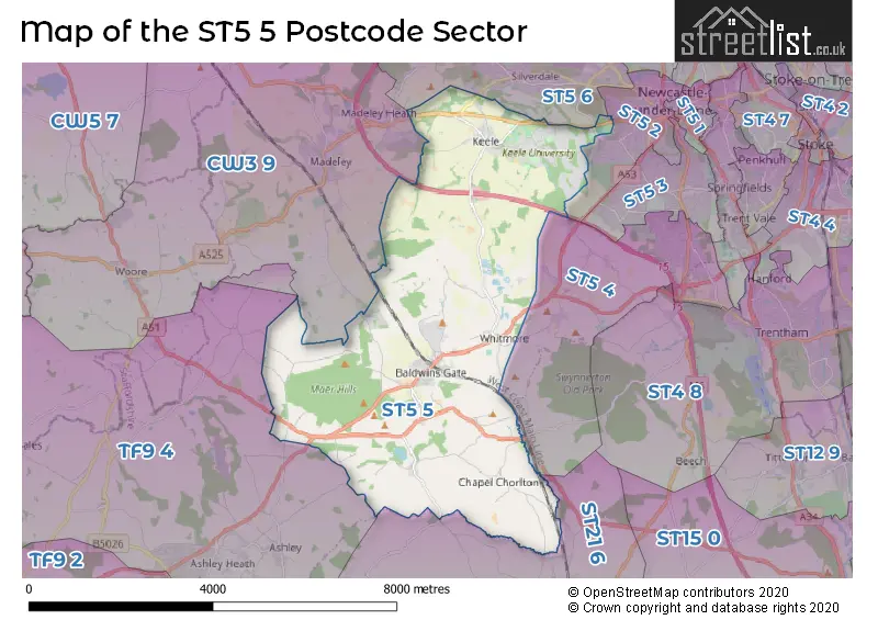
The ST5 5 Postcode shares a border with TF9 4 (Loggerheads, Ashley, Norton-in-Hales), ST3 4 (STOKE-ON-TRENT), ST5 2 (NEWCASTLE), ST5 4 (NEWCASTLE, Butterton, Acton), ST5 6 (NEWCASTLE, Silverdale, Knutton), ST21 6 (Eccleshall, Cotes Heath, Standon) and CW3 9 (Madeley, Woore, Betley).
The sector is within the post town of NEWCASTLE.
ST5 5 is a postcode sector within the ST5 postcode district which is within the ST Stoke-on-Trent postcode area.
The Royal Mail delivery office for the ST5 5 postal sector is the Newcastle Under Lyme Delivery Office.
The area of the ST5 5 postcode sector is 14.87 square miles which is 38.51 square kilometres or 9,516.70 square acres.
The ST5 5 postcode sector is crossed by the M6 motorway.

Map of the ST5 5 Postcode Sector
Explore the ST5 5 postcode sector by using our free interactive map.
| S | T | 5 | - | 5 | X | X |
| S | T | 5 | Space | 5 | Letter | Letter |
Official List of Streets
Whitmore (12 Streets)
Chapel Chorlton (2 Streets)
Baldwins Gate (33 Streets)
Keele (27 Streets)
Hill Chorlton (2 Streets)
Maer (5 Streets)
NEWCASTLE (2 Streets)
Blackbrook (4 Streets)
Stableford (1 Streets)
Unofficial Streets or Alternative Spellings
NEWCASTLE
GALINGALE VIEW GALLOWSTREE LANEButterton
LYMES ROAD WHITMORE ROADStandon
BUTTHOUSE LANE MAER LANE ACCESS ROAD 7 ACTON ROAD BADGER LANE BARKERS WOOD ROAD BARNES HALL ROAD BENT LANE BLUEBEK BANK CAMP HILL CENTRAL DRIVE CHORLTON GREEN CLAYALDERS BANK FENNEL PLACE HEATH RISE HERON POOL DRIVE HOLLY BUSH LANE HOLLY MEWS HOLLYWOOD LANE HORWOOD HALL AVENUE HORWOOD HALL ROAD KEELE DRIVE KEELE HALL ROAD KENNELS LANE LIME AVENUE LINDSEY HALL ROAD LITTLE LANE MAER HILLS LANE MILL LANE NURSERY ROAD OAK TREE ROAD OBSERVATORY WALK RECTORY LANE ROSEMARY HILL SCHOOL BANK SOUTH WOOD STABLEFORD BANK STABLEFORD COURT UNIVERSITY DRIVE UNVERSITY DRIVE WHARMADINE LANE WILKINS PLECKAshley
NEWCASTLE ROADWeather Forecast for ST5 5
Press Button to Show Forecast for Whitmore Hall
| Time Period | Icon | Description | Temperature | Rain Probability | Wind |
|---|---|---|---|---|---|
| 09:00 to 12:00 | Cloudy | 16.0°C (feels like 14.0°C) | 3.00% | ESE 11 mph | |
| 12:00 to 15:00 | Partly cloudy (day) | 20.0°C (feels like 17.0°C) | 0.00% | SE 11 mph | |
| 15:00 to 18:00 | Cloudy | 21.0°C (feels like 19.0°C) | 3.00% | SE 11 mph | |
| 18:00 to 21:00 | Cloudy | 20.0°C (feels like 18.0°C) | 3.00% | ESE 9 mph | |
| 21:00 to 00:00 | Cloudy | 17.0°C (feels like 15.0°C) | 3.00% | ESE 13 mph |
Press Button to Show Forecast for Whitmore Hall
| Time Period | Icon | Description | Temperature | Rain Probability | Wind |
|---|---|---|---|---|---|
| 00:00 to 03:00 | Cloudy | 14.0°C (feels like 12.0°C) | 3.00% | ESE 11 mph | |
| 03:00 to 06:00 | Cloudy | 12.0°C (feels like 10.0°C) | 3.00% | E 9 mph | |
| 06:00 to 09:00 | Cloudy | 13.0°C (feels like 11.0°C) | 3.00% | ESE 11 mph | |
| 09:00 to 12:00 | Cloudy | 17.0°C (feels like 15.0°C) | 3.00% | ESE 11 mph | |
| 12:00 to 15:00 | Cloudy | 20.0°C (feels like 18.0°C) | 13.00% | ESE 11 mph | |
| 15:00 to 18:00 | Light rain shower (day) | 21.0°C (feels like 19.0°C) | 36.00% | SE 11 mph | |
| 18:00 to 21:00 | Light rain shower (day) | 19.0°C (feels like 18.0°C) | 39.00% | SSE 7 mph | |
| 21:00 to 00:00 | Partly cloudy (night) | 16.0°C (feels like 15.0°C) | 30.00% | SE 7 mph |
Press Button to Show Forecast for Whitmore Hall
| Time Period | Icon | Description | Temperature | Rain Probability | Wind |
|---|---|---|---|---|---|
| 00:00 to 03:00 | Clear night | 14.0°C (feels like 13.0°C) | 10.00% | SSE 7 mph | |
| 03:00 to 06:00 | Partly cloudy (night) | 12.0°C (feels like 11.0°C) | 8.00% | SSE 7 mph | |
| 06:00 to 09:00 | Cloudy | 13.0°C (feels like 11.0°C) | 9.00% | S 9 mph | |
| 09:00 to 12:00 | Cloudy | 14.0°C (feels like 12.0°C) | 11.00% | SSE 13 mph | |
| 12:00 to 15:00 | Cloudy | 16.0°C (feels like 13.0°C) | 15.00% | SSE 16 mph | |
| 15:00 to 18:00 | Cloudy | 16.0°C (feels like 13.0°C) | 22.00% | SSE 16 mph | |
| 18:00 to 21:00 | Light rain | 14.0°C (feels like 12.0°C) | 57.00% | SE 16 mph | |
| 21:00 to 00:00 | Heavy rain | 13.0°C (feels like 11.0°C) | 80.00% | SE 13 mph |
Press Button to Show Forecast for Whitmore Hall
| Time Period | Icon | Description | Temperature | Rain Probability | Wind |
|---|---|---|---|---|---|
| 00:00 to 03:00 | Heavy rain | 13.0°C (feels like 10.0°C) | 77.00% | SE 13 mph | |
| 03:00 to 06:00 | Light rain | 12.0°C (feels like 10.0°C) | 56.00% | SSE 11 mph | |
| 06:00 to 09:00 | Light rain | 12.0°C (feels like 10.0°C) | 53.00% | SE 11 mph | |
| 09:00 to 12:00 | Light rain shower (day) | 13.0°C (feels like 11.0°C) | 43.00% | SSE 11 mph | |
| 12:00 to 15:00 | Light rain shower (day) | 15.0°C (feels like 13.0°C) | 43.00% | SSE 13 mph | |
| 15:00 to 18:00 | Light rain shower (day) | 16.0°C (feels like 13.0°C) | 43.00% | SSE 13 mph | |
| 18:00 to 21:00 | Light rain shower (day) | 15.0°C (feels like 12.0°C) | 38.00% | SSE 11 mph | |
| 21:00 to 00:00 | Partly cloudy (night) | 12.0°C (feels like 10.0°C) | 6.00% | SSE 11 mph |
Press Button to Show Forecast for Whitmore Hall
| Time Period | Icon | Description | Temperature | Rain Probability | Wind |
|---|---|---|---|---|---|
| 00:00 to 03:00 | Partly cloudy (night) | 11.0°C (feels like 8.0°C) | 6.00% | SSE 11 mph | |
| 03:00 to 06:00 | Cloudy | 10.0°C (feels like 8.0°C) | 8.00% | SE 11 mph | |
| 06:00 to 09:00 | Cloudy | 11.0°C (feels like 8.0°C) | 10.00% | SSE 11 mph | |
| 09:00 to 12:00 | Light rain shower (day) | 13.0°C (feels like 11.0°C) | 31.00% | SSE 13 mph | |
| 12:00 to 15:00 | Light rain shower (day) | 15.0°C (feels like 12.0°C) | 39.00% | SSE 13 mph | |
| 15:00 to 18:00 | Light rain shower (day) | 15.0°C (feels like 13.0°C) | 43.00% | S 11 mph | |
| 18:00 to 21:00 | Light rain shower (day) | 14.0°C (feels like 13.0°C) | 40.00% | S 11 mph | |
| 21:00 to 00:00 | Clear night | 11.0°C (feels like 9.0°C) | 3.00% | S 9 mph |
Schools and Places of Education Within the ST5 5 Postcode Sector
Baldwins Gate CofE(VC) Primary School
Voluntary controlled school
Tollgate Avenue, Newcastle-Under-Lyme, Staffordshire, ST5 5DF
Head: Mrs Leanne Lowndes
Ofsted Rating: Good
Inspection: 2022-09-22 (597 days ago)
Website: Visit Baldwins Gate CofE(VC) Primary School Website
Phone: 01782680649
Number of Pupils: 164
St John's CofE (C) Primary School
Voluntary controlled school
Quarry Bank Road, Newcastle, Staffordshire, ST5 5AF
Head: Mrs Sarita Bailey
Ofsted Rating: Requires improvement
Inspection: 2023-06-07 (339 days ago)
Website: Visit St John's CofE (C) Primary School Website
Phone: 01782987140
Number of Pupils: 187
University of Keele
Higher education institutions
, Keele, Staffordshire, ST5 5BG
Head: Professor Trevor McMillan
Ofsted Rating: Good
Inspection: 2023-06-16 (330 days ago)
Website: Visit University of Keele Website
Phone: 01782621111
Number of Pupils: 0
House Prices in the ST5 5 Postcode Sector
| Type of Property | 2018 Average | 2018 Sales | 2017 Average | 2017 Sales | 2016 Average | 2016 Sales | 2015 Average | 2015 Sales |
|---|---|---|---|---|---|---|---|---|
| Detached | £374,504 | 40 | £428,000 | 29 | £391,429 | 39 | £394,616 | 28 |
| Semi-Detached | £243,298 | 10 | £209,442 | 7 | £229,317 | 3 | £207,600 | 2 |
| Terraced | £210,500 | 2 | £192,375 | 4 | £176,961 | 9 | £194,885 | 5 |
| Flats | £0 | 0 | £0 | 0 | £0 | 0 | £0 | 0 |
Important Postcodes ST5 5 in the Postcode Sector
ST5 5AB is the postcode for Keele Cemetery Office & Vistor Centre, Keele Road
ST5 5AF is the postcode for Staffordshire County Council, St. Johns C of E Cp School, Quarry Bank Road
ST5 5AZ is the postcode for 59, The Covert, Keele
ST5 5BG is the postcode for UNIVERSITY OF KEELE DAY NURSERY, University of Keele, Keele, HAWTHORNS - Z BLOCK, University of Keele, Keele, LIBRARY, University of Keele, Keele, BARNES - D BLOCK, University of Keele, Keele, LINDSAY COURT, University of Keele, Keele, HAWTHORNS- D BLOCK, University of Keele, Keele, CONFERENCE HOTEL, University of Keele, Keele, PHARMACY, University of Keele, Keele, WILLIAM EMES BUILDING, University of Keele, Keele, HAWTHORNS - E BLOCK, University of Keele, Keele, WALTER MOBBERLY BUILDING, University of Keele, Keele, COMPUTER CENTRE BUILDING, University of Keele, Keele, HAWTHORNES -A BLOCK, University of Keele, Keele, BARNES - G BLOCK, University of Keele, Keele, HORWOOD - M BLOCK, University of Keele, Keele, SNEYD HOUSE, University of Keele, Keele, BARNES - H BLOCK, University of Keele, Keele, BARNES - A BLOCK, University of Keele, Keele, HAWTHORNS REFECTORY, University of Keele, Keele, SPORTS CENTRE, University of Keele, Keele, BARNES F-BLOCK, University of Keele, Keele, UNIT C - FOODSTORE SHOP, University of Keele, Keele, HAWTHORNS BLOCK C, University of Keele, Keele, WILLIAM SMITH (GEOLOGY), University of Keele, Keele, CLAUS MOSER BUILDING, University of Keele, Keele, KEELE HALL, University of Keele, Keele, UGMS, University of Keele, Keele, DOROTHY HODGKIN BUILDING, University of Keele, Keele, HORWOOD - O BLOCK, University of Keele, Keele, THE OAKES - BLOCK A, University of Keele, Keele, HUXLEY BUILDING, University of Keele, Keele, CHANCELLORS BUILDING, University of Keele, Keele, STUDENTS UNION, University of Keele, Keele, JACK ASHLEY, University of Keele, Keele, COLIN REEVES, University of Keele, Keele, MUSIC BUILDING, University of Keele, Keele, HAWTHORNS - F BLOCK, University of Keele, Keele, LINDSAY MUSIC THEATRE, University of Keele, Keele, CB NEW RESTAURANT, University of Keele, Keele, LEONARD JONES MULTI-USER LABORATORY, University of Keele, Keele, TAYLOR HOUSE, University of Keele, Keele, BARNES J BLOCK, University of Keele, Keele, Main Building, Colin Reeves (Computer Centre), COLIN REEVES, VISUAL ARTS AND BOOKBINDING, University of Keele, Keele, BARNES - E BLOCK, University of Keele, Keele, CHANCELLORS BUILDING & COMUS RESTAURANT, University of Keele, Keele, BARNES - C BLOCK, University of Keele, Keele, HORNBEAM (GEOGRAPHY), University of Keele, Keele, TAWNEY BUILDING, University of Keele, Keele, BARNES - W BLOCK, University of Keele, Keele, HOLLY CROSS, University of Keele, Keele, DAVID WEATHERALL, University of Keele, Keele, BARNES - K BLOCK, University of Keele, Keele, KEELE UNIVERSITY HOME FARM, University of Keele, Keele, HAWTHORNS - B BLOCK, University of Keele, Keele, LINDSAY REFECTORY, University of Keele, Keele, HORWOOD REFECTORY, University of Keele, Keele, HARROWBY HOUSE, University of Keele, Keele, THE OAKES - BLOCK B, University of Keele, Keele, COMUS RESTAURANT, University of Keele, Keele, BARNES - B BLOCK, University of Keele, Keele, HEALTH CENTRE, University of Keele, Keele, SCIENCE LEARNING CENTRE, University of Keele, Keele, DARWIN BUILDING, University of Keele, Keele, CHEMISTRY BUILDING, University of Keele, Keele, BARNES - L BLOCK, University of Keele, Keele, HORWOOD - H BLOCK, University of Keele, Keele, HAWTHORNS - X BLOCK, University of Keele, Keele, HORWOOD - J BLOCK, University of Keele, Keele, MACKAY BUILDING, University of Keele, Keele, and BARNES - X BLOCK, University of Keele, Keele
ST5 5DF is the postcode for Staffordshire County Council, Baldwins Gate C of E Primary School, Tollgate Avenue
ST5 5DZ is the postcode for BLOCK Y BARNES HALL, Keele University, Student Accommodation Barnes Hall,, and BLOCK Z BARNES HALL, Keele University, Student Accommodation Barnes Hall,
ST5 5NB is the postcode for IC1 Innovation Centre, University of Keele, and IC1 Innovation Centre, University of Keele, Keele
ST5 5NH is the postcode for IC2,Keele University, Science Park, Keele, and IC2,Keele University, Science Park
ST5 5NL is the postcode for Med IC4 Keele University, Science Park, and Med IC4 Keele University, Science Park, Keele
ST5 5NP is the postcode for Med IC3 Keele University, Science Park, and Med IC3 Keele University, Science Park, Keele
ST5 5NS is the postcode for Keele University Science & Innovation Park, Innovation Park, Keele
ST5 5NT is the postcode for IC5, INNOVATION WAY, KEELE
| The ST5 5 Sector is within these Local Authorities |
|
|---|---|
| The ST5 5 Sector is within these Counties |
|
| The ST5 5 Sector is within these Water Company Areas |
|
Tourist Attractions within the ST5 5 Postcode Area
We found 1 visitor attractions within the ST5 postcode area
| Whitmore Hall |
|---|
| Historic Properties |
| Historic House / House and Garden / Palace |
| View Whitmore Hall on Google Maps |