The ST5 6 postcode sector is within the county of Staffordshire.
Did you know? According to the 2021 Census, the ST5 6 postcode sector is home to a bustling 9,556 residents!
Given that each sector allows for 400 unique postcode combinations. Letters C, I, K, M, O and V are not allowed in the last two letters of a postcode. With 221 postcodes already in use, this leaves 179 units available.
The largest settlement in the ST5 6 postal code is NEWCASTLE followed by Silverdale, and Knutton.
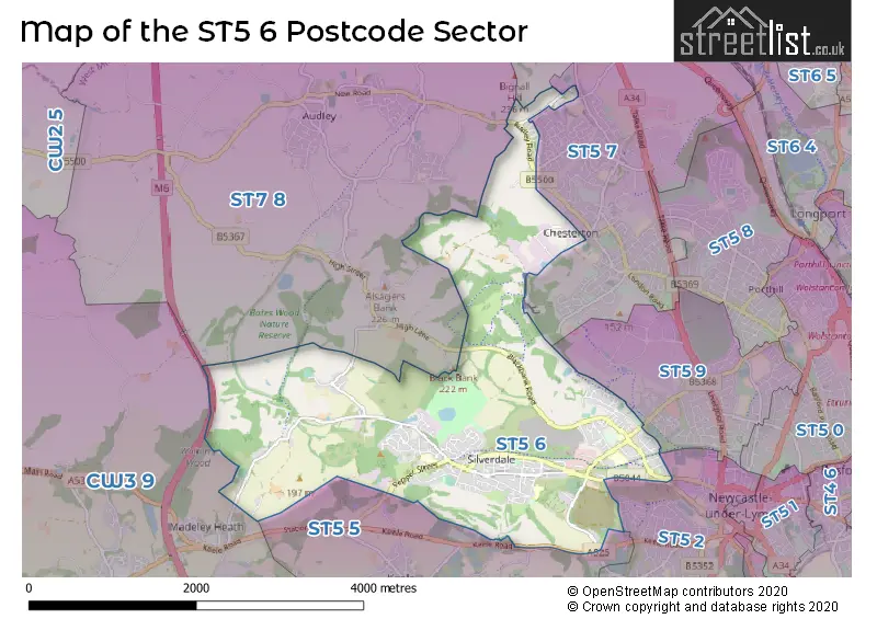
The ST5 6 Postcode shares a border with ST7 1 (Talke, Kidsgrove, Talke Pits), ST7 8 (Bignall End, Audley, Halmer End), ST5 2 (NEWCASTLE), ST5 5 (Keele, Baldwins Gate, Whitmore), ST5 7 (NEWCASTLE, Chesterton, Parkhouse Industrial Estate East), ST5 9 (NEWCASTLE, Lymedale Business Park, Cross Heath) and CW3 9 (Madeley, Woore, Betley).
The sector is within the post town of NEWCASTLE.
ST5 6 is a postcode sector within the ST5 postcode district which is within the ST Stoke-on-Trent postcode area.
The Royal Mail delivery office for the ST5 6 postal sector is the Newcastle Under Lyme Delivery Office.
The area of the ST5 6 postcode sector is 4.71 square miles which is 12.19 square kilometres or 3,011.68 square acres.
The ST5 6 postcode sector is crossed by the M6 motorway.

Map of the ST5 6 Postcode Sector
Explore the ST5 6 postcode sector by using our free interactive map.
| S | T | 5 | - | 6 | X | X |
| S | T | 5 | Space | 6 | Letter | Letter |
Official List of Streets
NEWCASTLE (106 Streets)
Leycett (6 Streets)
Silverdale (37 Streets)
Scot Hay (4 Streets)
Knutton (9 Streets)
Rowhurst Industrial Estate (2 Streets)
Unofficial Streets or Alternative Spellings
NEWCASTLE
KEELE ROAD LOOMER ROAD WALKERSGREEN ROADAlsagers Bank
HIGH LANE SCOT HAY ROAD THE DRIVEBignall End
BIGNALL HILLKeele
PEPPER STREETLeycett
PARK TERRACEWeather Forecast for ST5 6
Press Button to Show Forecast for Silverdale
| Time Period | Icon | Description | Temperature | Rain Probability | Wind |
|---|---|---|---|---|---|
| 00:00 to 03:00 | Cloudy | 5.0°C (feels like 2.0°C) | 6.00% | E 9 mph | |
| 03:00 to 06:00 | Cloudy | 4.0°C (feels like 1.0°C) | 6.00% | E 9 mph | |
| 06:00 to 09:00 | Cloudy | 5.0°C (feels like 1.0°C) | 5.00% | ENE 9 mph | |
| 09:00 to 12:00 | Cloudy | 7.0°C (feels like 5.0°C) | 9.00% | ENE 11 mph | |
| 12:00 to 15:00 | Cloudy | 9.0°C (feels like 6.0°C) | 16.00% | ENE 11 mph | |
| 15:00 to 18:00 | Overcast | 8.0°C (feels like 6.0°C) | 19.00% | ENE 11 mph | |
| 18:00 to 21:00 | Overcast | 8.0°C (feels like 5.0°C) | 13.00% | ENE 9 mph | |
| 21:00 to 00:00 | Cloudy | 6.0°C (feels like 4.0°C) | 5.00% | NE 9 mph |
Press Button to Show Forecast for Silverdale
| Time Period | Icon | Description | Temperature | Rain Probability | Wind |
|---|---|---|---|---|---|
| 00:00 to 03:00 | Cloudy | 5.0°C (feels like 3.0°C) | 7.00% | NNE 7 mph | |
| 03:00 to 06:00 | Cloudy | 5.0°C (feels like 2.0°C) | 10.00% | N 9 mph | |
| 06:00 to 09:00 | Light rain | 5.0°C (feels like 1.0°C) | 54.00% | N 9 mph | |
| 09:00 to 12:00 | Light rain | 6.0°C (feels like 3.0°C) | 53.00% | NNW 11 mph | |
| 12:00 to 15:00 | Overcast | 8.0°C (feels like 6.0°C) | 21.00% | NW 11 mph | |
| 15:00 to 18:00 | Cloudy | 10.0°C (feels like 7.0°C) | 13.00% | WNW 11 mph | |
| 18:00 to 21:00 | Sunny day | 9.0°C (feels like 7.0°C) | 4.00% | WNW 9 mph | |
| 21:00 to 00:00 | Clear night | 6.0°C (feels like 3.0°C) | 1.00% | WSW 7 mph |
Press Button to Show Forecast for Silverdale
| Time Period | Icon | Description | Temperature | Rain Probability | Wind |
|---|---|---|---|---|---|
| 00:00 to 03:00 | Clear night | 4.0°C (feels like 2.0°C) | 2.00% | SSW 7 mph | |
| 03:00 to 06:00 | Clear night | 4.0°C (feels like 1.0°C) | 1.00% | S 7 mph | |
| 06:00 to 09:00 | Sunny day | 5.0°C (feels like 2.0°C) | 1.00% | SSE 9 mph | |
| 09:00 to 12:00 | Partly cloudy (day) | 10.0°C (feels like 7.0°C) | 2.00% | S 13 mph | |
| 12:00 to 15:00 | Overcast | 12.0°C (feels like 9.0°C) | 10.00% | S 13 mph | |
| 15:00 to 18:00 | Cloudy | 13.0°C (feels like 10.0°C) | 7.00% | S 13 mph | |
| 18:00 to 21:00 | Cloudy | 12.0°C (feels like 10.0°C) | 6.00% | S 11 mph | |
| 21:00 to 00:00 | Clear night | 9.0°C (feels like 7.0°C) | 2.00% | SSE 9 mph |
Press Button to Show Forecast for Silverdale
| Time Period | Icon | Description | Temperature | Rain Probability | Wind |
|---|---|---|---|---|---|
| 00:00 to 03:00 | Clear night | 8.0°C (feels like 5.0°C) | 3.00% | SE 9 mph | |
| 03:00 to 06:00 | Partly cloudy (night) | 7.0°C (feels like 4.0°C) | 2.00% | ESE 11 mph | |
| 06:00 to 09:00 | Sunny day | 8.0°C (feels like 5.0°C) | 2.00% | ESE 11 mph | |
| 09:00 to 12:00 | Partly cloudy (day) | 12.0°C (feels like 9.0°C) | 5.00% | ESE 13 mph | |
| 12:00 to 15:00 | Cloudy | 14.0°C (feels like 12.0°C) | 11.00% | SE 13 mph | |
| 15:00 to 18:00 | Cloudy | 15.0°C (feels like 12.0°C) | 11.00% | SE 11 mph | |
| 18:00 to 21:00 | Partly cloudy (day) | 14.0°C (feels like 12.0°C) | 8.00% | ESE 9 mph | |
| 21:00 to 00:00 | Partly cloudy (night) | 11.0°C (feels like 9.0°C) | 4.00% | E 9 mph |
Schools and Places of Education Within the ST5 6 Postcode Sector
Cedars - Newcastle, Moorlands and Darwin Bases
Pupil referral unit
High Street, Newcastle-under-Lyme, Staffordshire, ST5 6BX
Head: Mrs Pam Clulow
Ofsted Rating: Good
Inspection: 2019-02-12 (1901 days ago)
Website: Visit Cedars - Newcastle, Moorlands and Darwin Bases Website
Phone: 01782973760
Number of Pupils: 30
Knutton St Marys CofE Academy
Academy sponsor led
Church Lane, Newcastle Under Lyme, Staffordshire, ST5 6EB
Head: Miss Lynn Davis
Ofsted Rating: Good
Inspection: 2019-05-09 (1815 days ago)
Website: Visit Knutton St Marys CofE Academy Website
Phone: 01782568680
Number of Pupils: 195
Silverdale Primary Academy
Academy sponsor led
Racecourse, Newcastle, Staffordshire, ST5 6PB
Head: Mrs Lindi Nejrup
Ofsted Rating: Good
Inspection: 2023-10-18 (192 days ago)
Website: Visit Silverdale Primary Academy Website
Phone: 01782973780
Number of Pupils: 160
St Luke's CofE (C) Primary School
Voluntary controlled school
Pepper Street, Newcastle, Staffordshire, ST5 6QJ
Head: Mrs Sam Ray
Ofsted Rating: Requires improvement
Inspection: 2022-11-23 (521 days ago)
Website: Visit St Luke's CofE (C) Primary School Website
Phone: 01782973865
Number of Pupils: 194
House Prices in the ST5 6 Postcode Sector
| Type of Property | 2018 Average | 2018 Sales | 2017 Average | 2017 Sales | 2016 Average | 2016 Sales | 2015 Average | 2015 Sales |
|---|---|---|---|---|---|---|---|---|
| Detached | £233,850 | 22 | £205,500 | 23 | £196,525 | 28 | £197,587 | 26 |
| Semi-Detached | £117,730 | 80 | £114,906 | 41 | £110,505 | 66 | £109,664 | 56 |
| Terraced | £106,722 | 66 | £91,601 | 45 | £87,226 | 60 | £97,236 | 36 |
| Flats | £115,500 | 2 | £62,000 | 1 | £0 | 0 | £0 | 0 |
Important Postcodes ST5 6 in the Postcode Sector
ST5 6BX is the postcode for Staffordshire County Council, High Street, and Knutton Recreation Centre, High Street
ST5 6DH is the postcode for Newcastle under Lyme Children's Centre, Cemetery Road
ST5 6EB is the postcode for Knutton St. Mary's C of E Primary School, Church Lane, and Knutton St. Mary's C of E Primary School, Church Lane, Knutton
ST5 6ED is the postcode for Royal Mail, Newcastle under Lyme Delivery Office, 1 Brock Way
ST5 6HF is the postcode for Knutton Lane Community Centre, Knutton Lane
ST5 6JT is the postcode for Staffordshire County Council, Brighton House Residential Home, Sneyd Terrace
ST5 6LL is the postcode for Silverdale Community Centre, Park Road
ST5 6LY is the postcode for Staffordshire County Council, Silverdale Library, High Street
ST5 6PB is the postcode for SILVERDALE PRIMARY SCHOOL, RACECOURSE, NEWCASTLE UNDER LYME, Staffordshire County Council, Silverdale Cp School, Racecourse, and Silverdale Primary School, Racecourse
ST5 6PS is the postcode for Silverdale Surgery, Vale Pleasant
ST5 6QJ is the postcode for ST LUKES CHURCH OF ENGLAND PRIMARY SCHOOL, PEPPER STREET, SILVERDALE, and St. Lukes C of E Cp School, Pepper Street
| The ST5 6 Sector is within these Local Authorities |
|
|---|---|
| The ST5 6 Sector is within these Counties |
|
| The ST5 6 Sector is within these Water Company Areas |
|