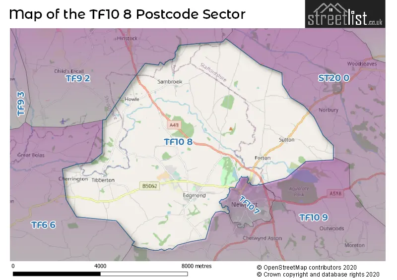
The TF10 8 postcode sector stands on the Shropshire and Staffordshire border.
Did you know? According to the 2021 Census, the TF10 8 postcode sector is home to a bustling 4,728 residents!
Given that each sector allows for 400 unique postcode combinations. Letters C, I, K, M, O and V are not allowed in the last two letters of a postcode. With 184 postcodes already in use, this leaves 216 units available.
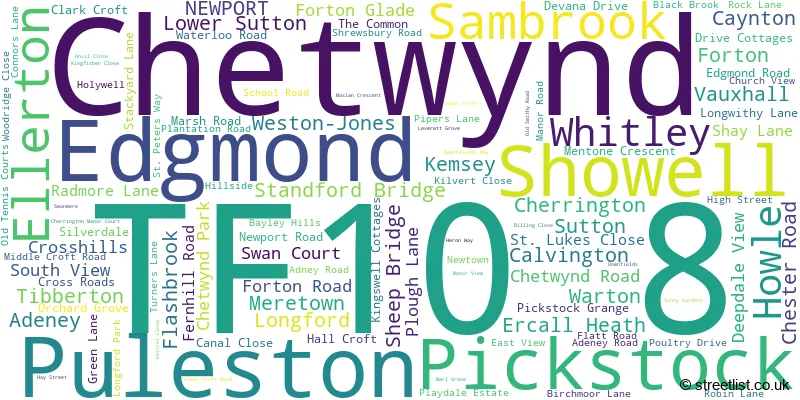
The largest settlement in the TF10 8 postal code is Edgmond followed by Tibberton, and NEWPORT.
The TF10 8 Postcode shares a border with TF6 6 (High Ercall, Waters Upton, Crudgington), TF9 2 (Hinstock, Cheswardine, Childs Ercall), TF10 7 (NEWPORT), TF10 9 (Lilleshall, Church Aston, Moreton) and ST20 0 (Gnosall, Church Eaton, Woodseaves).
The sector is within the post town of NEWPORT.
TF10 8 is a postcode sector within the TF1 postcode district which is within the TF Telford postcode area.
The Royal Mail delivery office for the TF10 8 postal sector is the unknown.
The area of the TF10 8 postcode sector is 26.58 square miles which is 68.85 square kilometres or 17,013.81 square acres.
Waterways within the TF10 8 postcode sector include the River Meese.

Map of the TF10 8 Postcode Sector
Explore the TF10 8 postcode sector by using our free interactive map.
| T | F | 1 | 0 | - | 8 | X | X |
| T | F | 1 | 0 | Space | 8 | Letter | Letter |
Official List of Streets
Tibberton (17 Streets)
NEWPORT (15 Streets)
Edgmond (30 Streets)
Cherrington (2 Streets)
Chetwynd (2 Streets)
Standford Bridge (1 Streets)
Flashbrook (1 Streets)
Sambrook (4 Streets)
Ellerton (2 Streets)
Sutton (3 Streets)
Longford (1 Streets)
Pickstock (1 Streets)
Forton (2 Streets)
Unofficial Streets or Alternative Spellings
Norbury
OULTON LANEGnosall
RADMORE LANE BACK LANE BAKERS LANE BLACK LANE CLIFFS LANE CONNERS LANE CROSSHILL LANE DAMFORD LANE DANFORD LANE GORSY LANE GUILD LANE LONGFORD HALL DRIVE MILL LANE SAINT PETERS WAY THE BUNGALOWS WALKLEY BANKNEWPORT
FALLOW DEER LAWN LONGFORD ROADChurch Aston
MOORFIELD LANELoynton
GREGORY LANEWeather Forecast for TF10 8
Press Button to Show Forecast for Winterbourne
| Time Period | Icon | Description | Temperature | Rain Probability | Wind |
|---|---|---|---|---|---|
| 06:00 to 09:00 | Cloudy | 9.0°C (feels like 6.0°C) | 5.00% | SE 13 mph | |
| 09:00 to 12:00 | Cloudy | 12.0°C (feels like 9.0°C) | 6.00% | SSE 16 mph | |
| 12:00 to 15:00 | Cloudy | 15.0°C (feels like 11.0°C) | 8.00% | SSE 16 mph | |
| 15:00 to 18:00 | Cloudy | 15.0°C (feels like 12.0°C) | 10.00% | S 13 mph | |
| 18:00 to 21:00 | Cloudy | 13.0°C (feels like 11.0°C) | 15.00% | S 9 mph | |
| 21:00 to 00:00 | Overcast | 11.0°C (feels like 10.0°C) | 14.00% | SSE 7 mph |
Press Button to Show Forecast for Winterbourne
| Time Period | Icon | Description | Temperature | Rain Probability | Wind |
|---|---|---|---|---|---|
| 00:00 to 03:00 | Cloudy | 10.0°C (feels like 8.0°C) | 10.00% | SSE 4 mph | |
| 03:00 to 06:00 | Cloudy | 9.0°C (feels like 7.0°C) | 8.00% | SSE 4 mph | |
| 06:00 to 09:00 | Cloudy | 8.0°C (feels like 7.0°C) | 7.00% | SSE 4 mph | |
| 09:00 to 12:00 | Cloudy | 11.0°C (feels like 11.0°C) | 7.00% | SSE 4 mph | |
| 12:00 to 15:00 | Cloudy | 14.0°C (feels like 13.0°C) | 10.00% | SE 4 mph | |
| 15:00 to 18:00 | Cloudy | 15.0°C (feels like 14.0°C) | 12.00% | ESE 4 mph | |
| 18:00 to 21:00 | Overcast | 14.0°C (feels like 14.0°C) | 17.00% | ENE 2 mph | |
| 21:00 to 00:00 | Cloudy | 12.0°C (feels like 11.0°C) | 12.00% | NNW 4 mph |
Press Button to Show Forecast for Winterbourne
| Time Period | Icon | Description | Temperature | Rain Probability | Wind |
|---|---|---|---|---|---|
| 00:00 to 03:00 | Cloudy | 11.0°C (feels like 10.0°C) | 16.00% | NNW 7 mph | |
| 03:00 to 06:00 | Cloudy | 10.0°C (feels like 9.0°C) | 14.00% | NNW 7 mph | |
| 06:00 to 09:00 | Cloudy | 10.0°C (feels like 9.0°C) | 12.00% | NNW 7 mph | |
| 09:00 to 12:00 | Cloudy | 13.0°C (feels like 12.0°C) | 9.00% | NNW 9 mph | |
| 12:00 to 15:00 | Cloudy | 16.0°C (feels like 15.0°C) | 9.00% | NNW 9 mph | |
| 15:00 to 18:00 | Partly cloudy (day) | 17.0°C (feels like 15.0°C) | 5.00% | N 9 mph | |
| 18:00 to 21:00 | Partly cloudy (day) | 16.0°C (feels like 14.0°C) | 5.00% | NNW 9 mph | |
| 21:00 to 00:00 | Clear night | 12.0°C (feels like 11.0°C) | 3.00% | N 9 mph |
Schools and Places of Education Within the TF10 8 Postcode Sector
St Peter's Church of England Controlled Primary School and Nursery
Voluntary controlled school
Stackyard Lane, Telford, Shropshire, TF10 8JQ
Head: Mrs Claire Medhurst
Ofsted Rating: Outstanding
Inspection: 2013-03-13 (4066 days ago)
Website: Visit St Peter's Church of England Controlled Primary School and Nursery Website
Phone: 01952811692
Number of Pupils: 225
Tibberton Church of England Primary School
Voluntary controlled school
Off Maslan Crescent, Newport, Shropshire, TF10 8NN
Head: Mrs Rebecca Nash
Ofsted Rating: Outstanding
Inspection: 2013-03-15 (4064 days ago)
Website: Visit Tibberton Church of England Primary School Website
Phone: 01952387790
Number of Pupils: 137
House Prices in the TF10 8 Postcode Sector
| Type of Property | 2018 Average | 2018 Sales | 2017 Average | 2017 Sales | 2016 Average | 2016 Sales | 2015 Average | 2015 Sales |
|---|---|---|---|---|---|---|---|---|
| Detached | £357,884 | 31 | £393,268 | 33 | £337,135 | 26 | £396,218 | 25 |
| Semi-Detached | £184,735 | 13 | £254,000 | 11 | £212,125 | 8 | £205,550 | 10 |
| Terraced | £309,500 | 3 | £311,500 | 10 | £201,125 | 8 | £335,000 | 2 |
| Flats | £147,000 | 1 | £118,000 | 1 | £0 | 0 | £0 | 0 |
Important Postcodes TF10 8 in the Postcode Sector
TF10 8JQ is the postcode for MAIN SCHOOL, St. Peters Primary School, Stackyard Lane
TF10 8JY is the postcode for Sandwell Metropolitan Borough Council Residential Centre, 41 High Street, and The Old Stables, High Street
TF10 8NB is the postcode for WESTON BUILDING, Harper Adams University College, Edgmond, POST GRADUATE DEVELOPMENT CENTRE, Harper Adams University College, Edgmond, Main Building, Harper Adams University, Edgmond, Regional Food Academy, Harper Adams University, Edgmond, FACCENDA CENTRE, Harper Adams University College, Edgmond, Block C, Harper Adams University, Edgmond, 2 Flatt Road, Harper Adams University, Edgmond, post graduate development centre, Harper Adams University, Edgmond, Weston Building, Harper Adams University, Edgmond, Darby Hall, Harper Adams University, Edgmond, Ward Hall, Harper Adams University, Edgmond, QUEEN MOTHER HALL, Harper Adams University College, Edgmond, Engineering Building, Harper Adams University, Edgmond, Princess Royal Hall, Harper Adams University, Edgmond, ENGINEERING BUILDING, Harper Adams University College, Edgmond, THE ELIZABETH CREAK BUILDING, Harper Adams University College, Edgmond, SPORTS HALL + STUDENT UNION, Harper Adams University College, Edgmond, Bamford Library, Harper Adams University, Edgmond, BAMFORD LIBRARY, Harper Adams University College, Edgmond, STUDENT UNION BAR, Harper Adams University College, Edgmond, Silcock Hall, Harper Adams University, Edgmond, Harris Hall, Harper Adams University, Edgmond, Elizabeth Creak Building, Harper Adams University, Edgmond, Students Union Bar, Harper Adams University, Edgmond, FOULKES-CROWTHER BUILDING + PRINCESS MARGARET SCIENCE BUILDING, Harper Adams University College, Edgmond, Jerman Hall, Harper Adams University, Edgmond, Darwin B Hall, Harper Adams University, Edgmond, Queen Mother Hall, Harper Adams University, Edgmond, REGIONAL FOOD ACADEMY, Harper Adams University College, Edgmond, MAIN BUILDING, Harper Adams University College, Edgmond, Leverhulme Hall, Harper Adams University, Edgmond, JUBILEE ADAMS, Harper Adams University College, Edgmond, Bradford Hall, Harper Adams University, Edgmond, Block B, Harper Adams University, Edgmond, AGRICULTURAL ENGINEERING INNOVATION CENTRE, Harper Adams University College, Edgmond, Gloucester Hall, Harper Adams University, Edgmond, Darwin A Hall, Harper Adams University, Edgmond, Jebb Hall, Harper Adams University, Edgmond, Agricultural Engineering Innovation Centre, Harper Adams University, Edgmond, Boughey Hall, Harper Adams University, Edgmond, A Block, Harper Adams University, Edgmond, C BLOCK, Harper Adams University College, Edgmond, Foulkes Crowther Building + Princess Margaret Science Building, Harper Adams University, Edgmond, Jubilee Adams Building, Harper Adams University, Edgmond, Faccenda Centre, Harper Adams University, Edgmond, and B BLOCK, Harper Adams University College, Edgmond
TF10 8NN is the postcode for MAIN SCHOOL, Tibberton CE Primary School, off Maslan Crescent
| The TF10 8 Sector is within these Local Authorities |
|
|---|---|
| The TF10 8 Sector is within these Counties |
|
| The TF10 8 Sector is within these Water Company Areas |
|