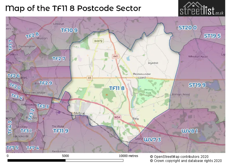
The TF11 8 postcode sector stands on the Shropshire and Staffordshire border.
Did you know? According to the 2021 Census, the TF11 8 postcode sector is home to a bustling 8,135 residents!
Given that each sector allows for 400 unique postcode combinations. Letters C, I, K, M, O and V are not allowed in the last two letters of a postcode. With 270 postcodes already in use, this leaves 130 units available.
The largest settlement in the TF11 8 postal code is SHIFNAL followed by Weston-under-Lizard, and Sheriffhales.
The TF11 8 Postcode shares a border with ST19 9 (Brewood, Wheaton Aston, Bishops Wood), TF2 7 (Donnington, Trench, Donnington Wood), TF3 3 (TELFORD), TF10 9 (Lilleshall, Church Aston, Moreton), TF11 9 (SHIFNAL, Beckbury, Norton), WV7 3 (Albrighton), ST20 0 (Gnosall, Church Eaton, Woodseaves), TF2 9 (St. Georges, Priorslee, TELFORD) and WV8 1 (Codsall, WOLVERHAMPTON, Pendeford).
The sector is within the post town of SHIFNAL.
TF11 8 is a postcode sector within the TF1 postcode district which is within the TF Telford postcode area.
The Royal Mail delivery office for the TF11 8 postal sector is the unknown.
The area of the TF11 8 postcode sector is 26.96 square miles which is 69.83 square kilometres or 17,254.54 square acres.
The TF11 8 postcode sector is crossed by the A41 Major A road.
The TF11 8 postcode sector is crossed by the M54 motorway.
Waterways within the TF11 8 postcode sector include the Worfe.

Map of the TF11 8 Postcode Sector
Explore the TF11 8 postcode sector by using our free interactive map.
| T | F | 1 | 1 | - | 8 | X | X |
| T | F | 1 | 1 | Space | 8 | Letter | Letter |
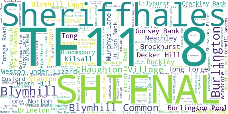
Official List of Streets
SHIFNAL (102 Streets)
Weston-under-Lizard (8 Streets)
Brineton (1 Streets)
Blymhill Lawn (2 Streets)
Blymhill (5 Streets)
Burlington (1 Streets)
Weston Heath (2 Streets)
Blymhill Common (1 Streets)
Sheriffhales (10 Streets)
Tong (2 Streets)
Neachley (2 Streets)
Ruckley (1 Streets)
Murphys Lane (1 Streets)
Unofficial Streets or Alternative Spellings
Wheaton Aston
BROADHOLES LANE ANSON ROAD BACK LANE BACK ROAD BEECH LANE BEIGHTERTON LANE BIRCHMOOR LANE BLYMHILL LAWN LANE BOWLERS ALLEY BROOKDALE BYMHILL LAWN LANE CASTLE FARM INTERCHANGE CHATWELL LANE CHESTER ROAD CHURCH LANE CONINGSBY ROAD FRIARS LANE GAY LANE GORTSY ROAD GREEN VIEW HALES COURT HOLYHEAD ROAD HONINGTON AVENUE HORSA WAY HUBBAL LANE KILSALL FARM LANE KING STREET KINLOSS AVENUE LARKRISE FIELDS LATCH GROVE LEEMING ROAD LEUCHARS LANE LICHFIELD DRIVE LILYHURST ROAD LYSANDER AVENUE MARHAM AVENUE MARSH ROAD MILL LANE NANNY MURPHYS LANE PLOUGH BANK SCHOOL COURT SHERIFFHALES DRIVE SHREWSBURY DRIVE STATION APPROACH STUMP LANE SWEETPLACE LANE TELFORD SERVICES THE BUTTS THE PADDOCK THE WILLOWS TONG DRIVE TONG INTERCHANGE TONG PARK DRIVE TONG PARK TRACK WATTISHAM WAY WOLLERY LANE WOOLLERY LANE WYTON AVENUEAlbrighton
NEWPORT ROADSHIFNAL
CHERRINGTON WAY CHURCH STREET THE PARADE VICARAGE DRIVEBishops Wood
OFFOXEY ROADWeather Forecast for TF11 8
Press Button to Show Forecast for Weston Park
| Time Period | Icon | Description | Temperature | Rain Probability | Wind |
|---|---|---|---|---|---|
| 03:00 to 06:00 | Cloudy | 9.0°C (feels like 6.0°C) | 5.00% | SSE 13 mph | |
| 06:00 to 09:00 | Cloudy | 9.0°C (feels like 6.0°C) | 5.00% | SE 13 mph | |
| 09:00 to 12:00 | Cloudy | 12.0°C (feels like 9.0°C) | 5.00% | SSE 16 mph | |
| 12:00 to 15:00 | Cloudy | 15.0°C (feels like 11.0°C) | 8.00% | SSE 16 mph | |
| 15:00 to 18:00 | Cloudy | 15.0°C (feels like 12.0°C) | 10.00% | S 13 mph | |
| 18:00 to 21:00 | Cloudy | 13.0°C (feels like 11.0°C) | 14.00% | S 9 mph | |
| 21:00 to 00:00 | Overcast | 10.0°C (feels like 9.0°C) | 17.00% | SSE 7 mph |
Press Button to Show Forecast for Weston Park
| Time Period | Icon | Description | Temperature | Rain Probability | Wind |
|---|---|---|---|---|---|
| 00:00 to 03:00 | Cloudy | 9.0°C (feels like 8.0°C) | 7.00% | SSE 4 mph | |
| 03:00 to 06:00 | Cloudy | 8.0°C (feels like 7.0°C) | 8.00% | SSE 4 mph | |
| 06:00 to 09:00 | Cloudy | 8.0°C (feels like 7.0°C) | 7.00% | SSE 4 mph | |
| 09:00 to 12:00 | Cloudy | 11.0°C (feels like 10.0°C) | 7.00% | SSE 4 mph | |
| 12:00 to 15:00 | Cloudy | 14.0°C (feels like 13.0°C) | 10.00% | SE 4 mph | |
| 15:00 to 18:00 | Cloudy | 15.0°C (feels like 14.0°C) | 12.00% | ESE 4 mph | |
| 18:00 to 21:00 | Overcast | 14.0°C (feels like 14.0°C) | 18.00% | N 4 mph | |
| 21:00 to 00:00 | Cloudy | 11.0°C (feels like 10.0°C) | 12.00% | N 7 mph |
Press Button to Show Forecast for Weston Park
| Time Period | Icon | Description | Temperature | Rain Probability | Wind |
|---|---|---|---|---|---|
| 00:00 to 03:00 | Cloudy | 10.0°C (feels like 9.0°C) | 16.00% | N 7 mph | |
| 03:00 to 06:00 | Cloudy | 10.0°C (feels like 9.0°C) | 14.00% | N 4 mph | |
| 06:00 to 09:00 | Cloudy | 10.0°C (feels like 9.0°C) | 12.00% | NNW 7 mph | |
| 09:00 to 12:00 | Cloudy | 13.0°C (feels like 11.0°C) | 10.00% | NNW 9 mph | |
| 12:00 to 15:00 | Partly cloudy (day) | 16.0°C (feels like 14.0°C) | 7.00% | NNW 9 mph | |
| 15:00 to 18:00 | Partly cloudy (day) | 17.0°C (feels like 15.0°C) | 5.00% | N 9 mph | |
| 18:00 to 21:00 | Partly cloudy (day) | 15.0°C (feels like 14.0°C) | 5.00% | NNW 9 mph | |
| 21:00 to 00:00 | Clear night | 11.0°C (feels like 10.0°C) | 3.00% | N 9 mph |
Schools and Places of Education Within the TF11 8 Postcode Sector
Idsall School
Academy converter
Coppice Green Lane, Shifnal, Shropshire, TF11 8PD
Head: Ms Michelle King
Ofsted Rating: Special Measures
Inspection: 2022-09-29 (579 days ago)
Website: Visit Idsall School Website
Phone: 01952468400
Number of Pupils: 1312
Lamledge School
Other independent special school
Lamledge Lane, Shifnal, Shropshire, TF11 8SD
Head: Ms Laura Smith
Ofsted Rating: Good
Inspection: 2022-10-20 (558 days ago)
Website: Visit Lamledge School Website
Phone: 07718118102
Number of Pupils: 56
Sheriffhales Primary School and Preschool
Community school
Sheriffhales, Shifnal, Shropshire, TF11 8RA
Head: Mrs Justine Keeling-Paglia
Ofsted Rating: Requires improvement
Inspection: 2023-03-06 (421 days ago)
Website: Visit Sheriffhales Primary School and Preschool Website
Phone: 01952460204
Number of Pupils: 67
Shifnal Primary School
Community school
Curriers Lane, Shifnal, Shropshire, TF11 8EJ
Head: Mr Adam Farrington
Ofsted Rating: Good
Inspection: 2023-03-03 (424 days ago)
Website: Visit Shifnal Primary School Website
Phone: 01952460500
Number of Pupils: 401
House Prices in the TF11 8 Postcode Sector
| Type of Property | 2018 Average | 2018 Sales | 2017 Average | 2017 Sales | 2016 Average | 2016 Sales | 2015 Average | 2015 Sales |
|---|---|---|---|---|---|---|---|---|
| Detached | £317,445 | 146 | £327,611 | 142 | £308,734 | 115 | £288,094 | 59 |
| Semi-Detached | £201,013 | 50 | £208,155 | 77 | £194,476 | 72 | £184,982 | 37 |
| Terraced | £187,986 | 19 | £188,970 | 47 | £186,565 | 40 | £188,452 | 21 |
| Flats | £106,744 | 8 | £105,833 | 6 | £107,690 | 5 | £104,500 | 6 |
Important Postcodes TF11 8 in the Postcode Sector
TF11 8EJ is the postcode for Shifnal Primary School, Curriers Lane
TF11 8PD is the postcode for THE OLD GYMNASIUM, Idsall School, Coppice Green Lane, and Idsall School, Coppice Green Lane
TF11 8RA is the postcode for Sheriffhales Primary School, Sheriffhales
TF11 8UP is the postcode for Hanger 2, RAF Museum, Cosford, Visitor Centre, RAF Museum, Cosford, National Cold War Exhibition, RAF Museum, Hanger 1, RAF Museum, Hanger 1, RAF Museum, Cosford, Hanger 3, RAF Museum, Cosford, Michael Beetham Conservation Centre, RAF Museum, National Cold War Exhibition, RAF Museum, Cosford, Hanger 2, RAF Museum, Hanger 3, RAF Museum, Visitor Centre, RAF Museum, and Michael Beetham Conservation Centre, RAF Museum, Cosford
| The TF11 8 Sector is within these Local Authorities |
|
|---|---|
| The TF11 8 Sector is within these Counties |
|
| The TF11 8 Sector is within these Water Company Areas |
|
Tourist Attractions within the TF11 8 Postcode Area
We found 1 visitor attractions within the TF1 postcode area
| Royal Air Force (RAF) Museum Cosford |
|---|
| Museums & Art Galleries |
| Museum and / or Art Gallery |
| View Royal Air Force (RAF) Museum Cosford on Google Maps |