The L28 postcode district is a postal district located in the L Liverpool postcode area with a population of 6,669 residents according to the 2021 England and Wales Census.
The area of the L28 postcode district is 0.66 square miles which is 1.71 square kilometres or 423.19 acres.
Currently, the L28 district has about 115 postcode units spread across 8 geographic postcode sectors.
Given that each sector allows for 400 unique postcode combinations, the district has a capacity of 3,200 postcodes. With 115 postcodes already in use, this leaves 3085 units available.
The largest settlements in the L28 postal code are LIVERPOOL and Stockbridge Village.
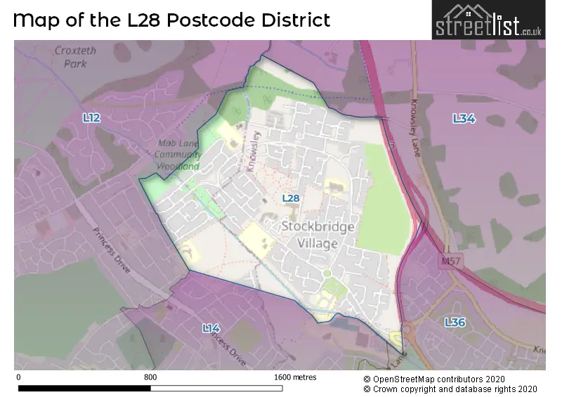
The L28 Postcode shares a border with L12 (LIVERPOOL, West Derby), L14 (LIVERPOOL, Knotty Ash, Broadgreen) and L34 (PRESCOT, Knowsley, Eccleston Park).
The primary settlement in the L28 postcode district is Liverpool in Merseyside, England. There are also significant settlements in Stockbridge Village. The most significant post town in this district is Liverpool.
For the district L28, we have data on 8 postcode sectors. Here's a breakdown: The sector L28 0, covers Liverpool in Merseyside. The sector L28 1, covers Liverpool in Merseyside. The sector L28 3, covers Liverpool in Merseyside. The sector L28 4, covers Liverpool in Merseyside. The sector L28 5, covers Liverpool and Stockbridge Village in Merseyside. The sector L28 6, covers Liverpool in Merseyside. The sector L28 7, covers Liverpool and Stockbridge Village in Merseyside. The sector L28 8, covers Liverpool in Merseyside.

Map of the L28 Postcode District
Explore the L28 postcode district by using our free interactive map.
When it comes to local government, postal geography often disregards political borders. However, for a breakdown in the L28 District: the district mostly encompasses the Knowsley District (B) (95 postcodes), and finally, the Liverpool District (B) area (20 postcodes).
Recent House Sales in L28
| Date | Price | Address |
|---|---|---|
| 12/07/2023 | £100,000 | Boode Croft, Liverpool, L28 4EN |
| 11/07/2023 | £120,000 | Corner Brook, Liverpool, L28 0QH |
| 10/07/2023 | £120,000 | The Court, Liverpool, L28 6YF |
| 20/06/2023 | £138,000 | Brandearth Hey, Liverpool, L28 1SD |
| 23/05/2023 | £95,000 | Custley Hey, Liverpool, L28 1RP |
| 05/05/2023 | £95,000 | Hare Croft, Liverpool, L28 8AE |
| 28/04/2023 | £105,000 | Steers Croft, Liverpool, L28 8AJ |
| 21/04/2023 | £112,500 | Little Moss Hey, Liverpool, L28 5RL |
| 21/04/2023 | £146,000 | Boode Croft, Liverpool, L28 4EN |
| 14/04/2023 | £117,500 | Corner Brook, Liverpool, L28 0QJ |
Where is the L28 Postcode District?
The postcode district L28 is located in Liverpool. It is situated near several towns. To the east, there is Prescot, which is approximately 3.17 miles away. To the northwest, there is Bootle, which is around 5.33 miles away. In the southeast, Widnes is located approximately 6.42 miles away. Wallasey is situated to the west and is around 7.67 miles away. Birkenhead is located in the southwest and is approximately 8.51 miles away. Lastly, to the northeast, there is Skelmersdale, which is around 8.65 miles away. Additionally, the distance between L28 and the center of London is roughly 176.43 miles.
The district is within the post town of LIVERPOOL.
The sector has postcodes within the nation of England.
The L28 Postcode District is covers the following regions.
- Liverpool - Merseyside - North West (England)
- East Merseyside - Merseyside - North West (England)
Weather Forecast for L28
Press Button to Show Forecast for Croxteth Hall
| Time Period | Icon | Description | Temperature | Rain Probability | Wind |
|---|---|---|---|---|---|
| 00:00 to 03:00 | Cloudy | 13.0°C (feels like 13.0°C) | 3.00% | NNE 2 mph | |
| 03:00 to 06:00 | Cloudy | 13.0°C (feels like 13.0°C) | 3.00% | S 2 mph | |
| 06:00 to 09:00 | Cloudy | 13.0°C (feels like 13.0°C) | 4.00% | SE 4 mph | |
| 09:00 to 12:00 | Cloudy | 17.0°C (feels like 16.0°C) | 4.00% | SE 4 mph | |
| 12:00 to 15:00 | Cloudy | 21.0°C (feels like 20.0°C) | 3.00% | S 4 mph | |
| 15:00 to 18:00 | Cloudy | 22.0°C (feels like 21.0°C) | 4.00% | S 7 mph | |
| 18:00 to 21:00 | Cloudy | 21.0°C (feels like 20.0°C) | 4.00% | SSW 7 mph | |
| 21:00 to 00:00 | Partly cloudy (night) | 17.0°C (feels like 17.0°C) | 1.00% | W 4 mph |
Press Button to Show Forecast for Croxteth Hall
| Time Period | Icon | Description | Temperature | Rain Probability | Wind |
|---|---|---|---|---|---|
| 00:00 to 03:00 | Partly cloudy (night) | 15.0°C (feels like 15.0°C) | 1.00% | WSW 2 mph | |
| 03:00 to 06:00 | Partly cloudy (night) | 14.0°C (feels like 14.0°C) | 0.00% | E 2 mph | |
| 06:00 to 09:00 | Partly cloudy (day) | 14.0°C (feels like 14.0°C) | 1.00% | SE 4 mph | |
| 09:00 to 12:00 | Partly cloudy (day) | 17.0°C (feels like 17.0°C) | 0.00% | SE 7 mph | |
| 12:00 to 15:00 | Partly cloudy (day) | 20.0°C (feels like 18.0°C) | 2.00% | SSE 9 mph | |
| 15:00 to 18:00 | Partly cloudy (day) | 21.0°C (feels like 19.0°C) | 1.00% | S 9 mph | |
| 18:00 to 21:00 | Partly cloudy (day) | 20.0°C (feels like 19.0°C) | 1.00% | S 7 mph | |
| 21:00 to 00:00 | Partly cloudy (night) | 18.0°C (feels like 17.0°C) | 1.00% | SSE 7 mph |
Press Button to Show Forecast for Croxteth Hall
| Time Period | Icon | Description | Temperature | Rain Probability | Wind |
|---|---|---|---|---|---|
| 00:00 to 03:00 | Partly cloudy (night) | 16.0°C (feels like 15.0°C) | 1.00% | SE 7 mph | |
| 03:00 to 06:00 | Cloudy | 15.0°C (feels like 14.0°C) | 3.00% | SE 9 mph | |
| 06:00 to 09:00 | Cloudy | 15.0°C (feels like 13.0°C) | 3.00% | SE 9 mph | |
| 09:00 to 12:00 | Partly cloudy (day) | 17.0°C (feels like 16.0°C) | 1.00% | SE 9 mph | |
| 12:00 to 15:00 | Cloudy | 20.0°C (feels like 18.0°C) | 6.00% | SSE 9 mph | |
| 15:00 to 18:00 | Light rain shower (day) | 20.0°C (feels like 18.0°C) | 36.00% | S 9 mph | |
| 18:00 to 21:00 | Heavy rain shower (day) | 18.0°C (feels like 16.0°C) | 53.00% | SSW 9 mph | |
| 21:00 to 00:00 | Light rain shower (night) | 16.0°C (feels like 15.0°C) | 38.00% | S 7 mph |
Press Button to Show Forecast for Croxteth Hall
| Time Period | Icon | Description | Temperature | Rain Probability | Wind |
|---|---|---|---|---|---|
| 00:00 to 03:00 | Overcast | 15.0°C (feels like 14.0°C) | 20.00% | SE 7 mph | |
| 03:00 to 06:00 | Light rain | 14.0°C (feels like 13.0°C) | 46.00% | SSW 7 mph | |
| 06:00 to 09:00 | Cloudy | 13.0°C (feels like 12.0°C) | 18.00% | SSE 7 mph | |
| 09:00 to 12:00 | Cloudy | 14.0°C (feels like 13.0°C) | 19.00% | SSW 9 mph | |
| 12:00 to 15:00 | Cloudy | 16.0°C (feels like 14.0°C) | 22.00% | SSW 9 mph | |
| 15:00 to 18:00 | Light rain | 16.0°C (feels like 14.0°C) | 49.00% | SSW 11 mph | |
| 18:00 to 21:00 | Heavy rain | 15.0°C (feels like 13.0°C) | 76.00% | SSW 11 mph | |
| 21:00 to 00:00 | Light rain | 14.0°C (feels like 12.0°C) | 54.00% | SSW 11 mph |
| Postcode Sector | Delivery Office |
|---|---|
| L28 0 | West Derby Delivery Office |
| L28 1 | West Derby Delivery Office |
| L28 3 | West Derby Delivery Office |
| L28 4 | West Derby Delivery Office |
| L28 5 | West Derby Delivery Office |
| L28 6 | West Derby Delivery Office |
| L28 7 | West Derby Delivery Office |
| L28 8 | West Derby Delivery Office |
| L | 2 | 8 | - | X | X | X |
| L | 2 | 8 | Space | Numeric | Letter | Letter |
Current Monthly Rental Prices
| # Bedrooms | Min Price | Max Price | Avg Price |
|---|---|---|---|
| 3 | £795 | £795 | £795 |
Current House Prices
| # Bedrooms | Min Price | Max Price | Avg Price |
|---|---|---|---|
| 2 | £75,000 | £90,000 | £84,250 |
| 3 | £110,000 | £150,000 | £122,000 |
Estate Agents who Operate in the L28 District
| Logo | Name | Brand Name | Address | Contact Number | Total Properties |
|---|---|---|---|---|---|
 | West Derby | Keybanks Estates | 11-13 West Derby Village, West Derby, Liverpool, L12 5HJ | 0151 453 8457 | 3 |
 | West Derby | Whitegates | 74 Mill Lane West Derby Liverpool L12 7JB | 0151 453 7273 | 2 |
 | Rainhill | Cameron Mackenzie | 509 Warrington Road Rainhill L35 4LP | 0151 453 9621 | 2 |
 | Allerton | Abode | 6 Allerton Road, Mossley Hill, Liverpool, L18 1LN | 0151 453 2774 | 1 |
 | Huyton | Cameron Mackenzie | 17 Tarbock Road, Huyton, Liverpool, L36 5XN | 0151 453 8807 | 1 |
Yearly House Price Averages for the L28 Postcode District
| Type of Property | 2018 Average | 2018 Sales | 2017 Average | 2017 Sales | 2016 Average | 2016 Sales | 2015 Average | 2015 Sales |
|---|---|---|---|---|---|---|---|---|
| Detached | £110,000 | 2 | £118,000 | 1 | £0 | 0 | £105,295 | 1 |
| Semi-Detached | £105,999 | 9 | £84,200 | 10 | £91,165 | 12 | £79,375 | 4 |
| Terraced | £66,881 | 21 | £70,000 | 20 | £60,500 | 17 | £57,325 | 20 |
| Flats | £0 | 0 | £0 | 0 | £0 | 0 | £0 | 0 |