The LL65 postcode district is a postal district located in the LL Llandudno postcode area with a population of 23,934 residents according to the 2021 England and Wales Census.
The area of the LL65 postcode district is 73.47 square miles which is 190.30 square kilometres or 47,023.38 acres.
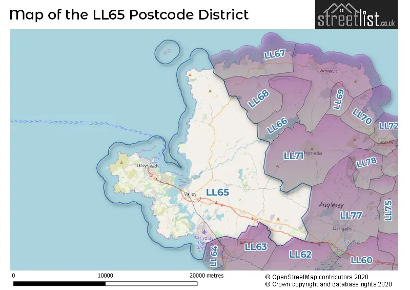
Currently, the LL65 district has about 911 postcode units spread across 4 geographic postcode sectors.
Given that each sector allows for 400 unique postcode combinations, the district has a capacity of 1,600 postcodes. With 911 postcodes already in use, this leaves 689 units available.
The largest settlement in the LL65 postal code is HOLYHEAD followed by TREARDDUR BAY, and VALLEY.
The postcode area has a boundary with Caernarfon Bay and The Irish Sea.
The LL65 Postcode shares a border with LL64 (RHOSNEIGR), LL63 (TY CROES, ABERFFRAW, LLANFAELOG), LL62 (BODORGAN, MALLTRAETH, LLANGRISTIOLUS), LL68 (AMLWCH, LLANFECHELL, BULL BAY) and LL71 (LLANERCHYMEDD, LLANDYFRYDOG, CARMEL).
The primary settlement in the LL65 postcode district is Holyhead, located in Gwynedd, Wales. Other significant settlements in the district include Four Mile Bridge, Kingsland, Penrhos, Penrhos Feilw, Porthdafarch, Rhoscolyn, Trearddur Bay, Bodedern, Bryngwran, Caergeiliog, Llanfair Yn Neubwll, Llanynghenedl, Trefor, Tyn Lon, Valley, Gwalchmai, Llanddeusant, Llanfachraeth, Llanfaethlu, Llanfairynghornwy, Llanfigael, Llanfwrog, Llanrhyddlad, Llantrisant, Rhydwyn, and Trefor. The most significant postal town in the LL65 postcode district is Holyhead.
For the district LL65, we have data on 4 postcode sectors. Here's a breakdown: The sector LL65 1, covers Holyhead in Gwynedd. The sector LL65 2, covers Holyhead and Trearddur Bay in Gwynedd. The sector LL65 3, covers Valley and Caergeiliog and Bodedern and Bryngwran in Gwynedd. The sector LL65 4, covers Gwalchmai and Llanfachraeth and Rhydwyn and Llanfaethlu and Llanddeusant in Gwynedd.


Map of the LL65 Postcode District
Explore the LL65 postcode district by using our free interactive map.
When it comes to local government, postal geography often disregards political borders. However, for a breakdown in the LL65 District: the district mostly encompasses the Sir Ynys Mon - Isle of Anglesey area with a total of 914 postcodes.
Recent House Sales in LL65
| Date | Price | Address |
|---|---|---|
| 23/10/2023 | £108,000 | Mill Bank, Holyhead, LL65 1TE |
| 13/10/2023 | £285,000 | Parc Tyddyn Bach, Holyhead, LL65 1NZ |
| 13/10/2023 | £210,000 | Trehwfa Road, Holyhead, LL65 1LE |
| 12/10/2023 | £95,000 | Nimrod Walk, Holyhead, LL65 2EW |
| 10/10/2023 | £395,000 | Vista Del Mar, Valley, Holyhead, LL65 3DS |
| 09/10/2023 | £450,000 | Lon Crecrist, Trearddur Bay, Holyhead, LL65 2AZ |
| 06/10/2023 | £75,000 | Arthur Street, Holyhead, LL65 2SF |
| 06/10/2023 | £395,000 | Vista Del Mar, Valley, Holyhead, LL65 3DS |
| 04/10/2023 | £220,000 | Garreglwyd Park, Holyhead, LL65 1NW |
| 04/10/2023 | £155,000 | Roberts Street, Holyhead, LL65 1SD |
Weather Forecast for LL65
Press Button to Show Forecast for Stryd Y Facsen
| Time Period | Icon | Description | Temperature | Rain Probability | Wind |
|---|---|---|---|---|---|
| 12:00 to 15:00 | Cloudy | 9.0°C (feels like 7.0°C) | 7.00% | ENE 11 mph | |
| 15:00 to 18:00 | Sunny day | 9.0°C (feels like 7.0°C) | 1.00% | NE 11 mph | |
| 18:00 to 21:00 | Sunny day | 8.0°C (feels like 5.0°C) | 2.00% | NE 11 mph | |
| 21:00 to 00:00 | Partly cloudy (night) | 6.0°C (feels like 3.0°C) | 5.00% | NE 9 mph |
Press Button to Show Forecast for Stryd Y Facsen
| Time Period | Icon | Description | Temperature | Rain Probability | Wind |
|---|---|---|---|---|---|
| 00:00 to 03:00 | Cloudy | 5.0°C (feels like 3.0°C) | 6.00% | ENE 7 mph | |
| 03:00 to 06:00 | Cloudy | 5.0°C (feels like 2.0°C) | 6.00% | ENE 9 mph | |
| 06:00 to 09:00 | Cloudy | 6.0°C (feels like 3.0°C) | 8.00% | ENE 9 mph | |
| 09:00 to 12:00 | Cloudy | 9.0°C (feels like 6.0°C) | 6.00% | ENE 11 mph | |
| 12:00 to 15:00 | Cloudy | 10.0°C (feels like 8.0°C) | 5.00% | ENE 11 mph | |
| 15:00 to 18:00 | Cloudy | 10.0°C (feels like 8.0°C) | 6.00% | NE 11 mph | |
| 18:00 to 21:00 | Cloudy | 9.0°C (feels like 6.0°C) | 6.00% | NE 9 mph | |
| 21:00 to 00:00 | Partly cloudy (night) | 7.0°C (feels like 4.0°C) | 2.00% | NE 9 mph |
Press Button to Show Forecast for Stryd Y Facsen
| Time Period | Icon | Description | Temperature | Rain Probability | Wind |
|---|---|---|---|---|---|
| 00:00 to 03:00 | Partly cloudy (night) | 7.0°C (feels like 4.0°C) | 2.00% | NE 9 mph | |
| 03:00 to 06:00 | Cloudy | 6.0°C (feels like 3.0°C) | 4.00% | NNE 7 mph | |
| 06:00 to 09:00 | Partly cloudy (day) | 7.0°C (feels like 4.0°C) | 1.00% | N 9 mph | |
| 09:00 to 12:00 | Sunny day | 9.0°C (feels like 7.0°C) | 1.00% | NNW 11 mph | |
| 12:00 to 15:00 | Partly cloudy (day) | 10.0°C (feels like 8.0°C) | 3.00% | NW 11 mph | |
| 15:00 to 18:00 | Sunny day | 10.0°C (feels like 8.0°C) | 1.00% | W 11 mph | |
| 18:00 to 21:00 | Sunny day | 10.0°C (feels like 7.0°C) | 1.00% | SW 13 mph | |
| 21:00 to 00:00 | Cloudy | 9.0°C (feels like 6.0°C) | 4.00% | SSW 13 mph |
Press Button to Show Forecast for Stryd Y Facsen
| Time Period | Icon | Description | Temperature | Rain Probability | Wind |
|---|---|---|---|---|---|
| 00:00 to 03:00 | Cloudy | 9.0°C (feels like 6.0°C) | 9.00% | SSW 16 mph | |
| 03:00 to 06:00 | Cloudy | 9.0°C (feels like 5.0°C) | 11.00% | S 16 mph | |
| 06:00 to 09:00 | Cloudy | 9.0°C (feels like 6.0°C) | 13.00% | S 18 mph | |
| 09:00 to 12:00 | Light rain shower (day) | 11.0°C (feels like 7.0°C) | 32.00% | S 22 mph | |
| 12:00 to 15:00 | Cloudy | 12.0°C (feels like 8.0°C) | 18.00% | S 22 mph | |
| 15:00 to 18:00 | Cloudy | 12.0°C (feels like 8.0°C) | 17.00% | S 20 mph | |
| 18:00 to 21:00 | Light rain | 11.0°C (feels like 8.0°C) | 44.00% | S 18 mph | |
| 21:00 to 00:00 | Cloudy | 10.0°C (feels like 7.0°C) | 15.00% | SSE 16 mph |
Press Button to Show Forecast for Stryd Y Facsen
| Time Period | Icon | Description | Temperature | Rain Probability | Wind |
|---|---|---|---|---|---|
| 00:00 to 03:00 | Cloudy | 10.0°C (feels like 7.0°C) | 14.00% | SSE 16 mph | |
| 03:00 to 06:00 | Cloudy | 9.0°C (feels like 6.0°C) | 14.00% | SE 16 mph | |
| 06:00 to 09:00 | Cloudy | 9.0°C (feels like 7.0°C) | 13.00% | SE 13 mph | |
| 09:00 to 12:00 | Partly cloudy (day) | 12.0°C (feels like 9.0°C) | 9.00% | SE 16 mph | |
| 12:00 to 15:00 | Cloudy | 14.0°C (feels like 12.0°C) | 12.00% | SE 13 mph | |
| 15:00 to 18:00 | Cloudy | 15.0°C (feels like 12.0°C) | 13.00% | SE 13 mph | |
| 18:00 to 21:00 | Cloudy | 14.0°C (feels like 12.0°C) | 10.00% | SE 9 mph | |
| 21:00 to 00:00 | Cloudy | 11.0°C (feels like 9.0°C) | 7.00% | E 9 mph |
Where is the LL65 Postcode District?
The LL65 postcode district is located in Holyhead. It is a district town in Wales. The nearby towns include Rhosneigr to the south, Llanerch-y-Medd to the east, Rhosgoch to the northeast, and Bodorgan to the southeast. The postcode district is approximately 223.19 miles away from the center of London.
The district is within the post town of HOLYHEAD.
The sector has postcodes within the nation of Wales.
The LL65 Postcode District is in the Isle of Anglesey region of West Wales within the Wales.
| Postcode Sector | Delivery Office |
|---|---|
| LL65 1 | Holyhead Delivery Office |
| LL65 2 | Holyhead Delivery Office |
| LL65 3 | Holyhead Delivery Office |
| LL65 4 | Holyhead Delivery Office |
| L | L | 6 | 5 | - | X | X | X |
| L | L | 6 | 5 | Space | Numeric | Letter | Letter |
Tourist Attractions within the Postcode Area
We found 3 visitor attractions within the LL65 postcode area
| Holyhead Breakwater Country Park |
|---|
| View Holyhead Breakwater Country Park on Google Maps |
| South Stack Lighthouse |
| View South Stack Lighthouse on Google Maps |
| South Stack Nature Reserve |
| View South Stack Nature Reserve on Google Maps |
Current Monthly Rental Prices
| # Bedrooms | Min Price | Max Price | Avg Price |
|---|---|---|---|
| 2 | £750 | £750 | £750 |
Current House Prices
| # Bedrooms | Min Price | Max Price | Avg Price |
|---|---|---|---|
| £6,000 | £1,250,000 | £249,167 | |
| 1 | £185,000 | £185,000 | £185,000 |
| 2 | £65,000 | £425,000 | £200,442 |
| 3 | £99,950 | £795,000 | £268,605 |
| 4 | £114,950 | £975,000 | £396,945 |
| 5 | £255,000 | £1,695,000 | £632,105 |
| 6 | £110,000 | £1,500,000 | £787,500 |
| 7 | £150,000 | £895,000 | £486,250 |
| 8 | £850,000 | £850,000 | £850,000 |
Estate Agents who Operate in the LL65 District
| Logo | Name | Brand Name | Address | Contact Number | Total Properties |
|---|---|---|---|---|---|
 | Holyhead | Williams & Goodwin The Property People | 2 Market Buildings Stanley Street, Holyhead, LL65 1HH | 01407 880151 | 56 |
 | Holyhead | Burnells | 15-17 Market Street, Holyhead, LL65 1UL | 01407 880630 | 36 |
 | Llangefni | Dafydd Hardy | 3 Sgwar Bulkeley Llangefni Ynys M�n LL77 7LR | 01248 661234 | 32 |
 | Holyhead | Beresford Adams | 7-9 Market Street Holyhead LL65 1UL | 01407 880631 | 20 |
 | Wales | eXp UK | 1 Northumberland Avenue, Trafalgar Square, London, WC2N 5BW | 03304 609968 | 10 |
- Bodedern
- Bryngwran
- Caergeiliog
- Capel Gwyn
- Engedi
- Four Mile Bridge
- Gwalchmai
- Holyhead
- Llanddeusant
- Llanfachraeth
- Llanfaethlu
- Llanfair-yng-Nghornwy
- Llanfigael
- Llanfihangel yn Nhowyn
- Llanrhuddlad
- Llanynghenedl
- Llynfaes
- Mona
- Mynydd Mechell
- Porth Swtan
- R Efail Estate
- Rhosneigr
- Rhyd-wyn
- Trearddur
- Trefor
- Y Fali
| Type of Property | 2018 Average | 2018 Sales | 2017 Average | 2017 Sales | 2016 Average | 2016 Sales | 2015 Average | 2015 Sales |
|---|---|---|---|---|---|---|---|---|
| Detached | £240,156 | 151 | £223,811 | 139 | £202,867 | 160 | £201,663 | 118 |
| Semi-Detached | £131,807 | 88 | £150,086 | 77 | £133,051 | 69 | £127,640 | 52 |
| Terraced | £102,454 | 122 | £95,085 | 104 | £93,755 | 110 | £85,408 | 106 |
| Flats | £146,981 | 16 | £149,438 | 8 | £115,962 | 13 | £130,900 | 20 |