The N7 postcode district is a postal district located in the N London - N postcode area with a population of 50,828 residents according to the 2021 England and Wales Census.
The area of the N7 postcode district is 1.33 square miles which is 3.44 square kilometres or 849.38 acres.
Currently, the N7 district has about 894 postcode units spread across 5 geographic postcode sectors.
Given that each sector allows for 400 unique postcode combinations, the district has a capacity of 2,000 postcodes. With 894 postcodes already in use, this leaves 1106 units available.
The N7 postal code covers the settlement of ISLINGTON.
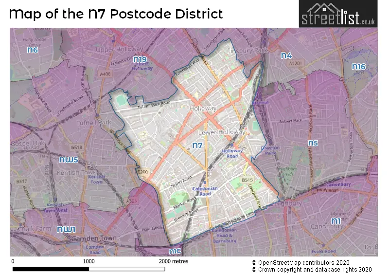
The N7 Postcode shares a border with NW5 (LONDON), N19 (ISLINGTON), N4 (HACKNEY, HORNSEY, ISLINGTON), N5 (ISLINGTON), N1C (LONDON) and N1 (ISLINGTON, HACKNEY).
The primary settlement in the N7 postcode district is Islington, located in the county of Greater London. Other significant settlements include Camden. The main post town is London, within the county of Greater London.
For the district N7, we have data on 6 postcode sectors. Here's a breakdown: The sector N7 0, covers Islington in Greater London. The sector N7 1 is non-geographic. It's often designated for PO Boxes, large organisations, or special services. The sector N7 6, covers Islington in Greater London. The sector N7 7, covers Islington in Greater London. The sector N7 8, covers Islington in Greater London. The sector N7 9, covers Islington in Greater London.

Map of the N7 Postcode District
Explore the N7 postcode district by using our free interactive map.
When it comes to local government, postal geography often disregards political borders. However, for a breakdown in the N7 District: the district mostly encompasses the Islington London Boro (879 postcodes), and finally, the Camden London Boro area (17 postcodes).
Recent House Sales in N7
| Date | Price | Address |
|---|---|---|
| 29/09/2023 | £250,000 | Clock View Crescent, London, N7 9GP |
| 26/09/2023 | £465,000 | Holloway Road, London, N7 9SS |
| 11/09/2023 | £440,000 | Hanmer Walk, London, N7 7RE |
| 08/09/2023 | £560,000 | Hornsey Road, London, N7 6DG |
| 08/09/2023 | £570,000 | Middleton Grove, London, N7 9LU |
| 07/09/2023 | £582,000 | Tabley Road, London, N7 0NQ |
| 06/09/2023 | £1,150,000 | Eburne Road, London, N7 6AU |
| 05/09/2023 | £565,500 | Arthur Road, London, N7 6DS |
| 04/09/2023 | £500,000 | Thane Villas, London, N7 7PA |
| 04/09/2023 | £545,000 | Morgan Road, London, N7 8NB |
Weather Forecast for N7
Press Button to Show Forecast for Arsenal F.C.
| Time Period | Icon | Description | Temperature | Rain Probability | Wind |
|---|---|---|---|---|---|
| 06:00 to 09:00 | Cloudy | 5.0°C (feels like 3.0°C) | 4.00% | NE 7 mph | |
| 09:00 to 12:00 | Cloudy | 8.0°C (feels like 6.0°C) | 4.00% | ENE 7 mph | |
| 12:00 to 15:00 | Cloudy | 10.0°C (feels like 9.0°C) | 11.00% | E 4 mph | |
| 15:00 to 18:00 | Cloudy | 11.0°C (feels like 10.0°C) | 12.00% | ENE 4 mph | |
| 18:00 to 21:00 | Cloudy | 10.0°C (feels like 9.0°C) | 13.00% | E 7 mph | |
| 21:00 to 00:00 | Cloudy | 7.0°C (feels like 5.0°C) | 11.00% | E 7 mph |
Press Button to Show Forecast for Arsenal F.C.
| Time Period | Icon | Description | Temperature | Rain Probability | Wind |
|---|---|---|---|---|---|
| 00:00 to 03:00 | Cloudy | 6.0°C (feels like 4.0°C) | 17.00% | ENE 7 mph | |
| 03:00 to 06:00 | Cloudy | 5.0°C (feels like 3.0°C) | 18.00% | NE 7 mph | |
| 06:00 to 09:00 | Cloudy | 6.0°C (feels like 4.0°C) | 21.00% | NE 7 mph | |
| 09:00 to 12:00 | Overcast | 10.0°C (feels like 8.0°C) | 18.00% | ENE 9 mph | |
| 12:00 to 15:00 | Cloudy | 12.0°C (feels like 10.0°C) | 14.00% | E 9 mph | |
| 15:00 to 18:00 | Light rain | 12.0°C (feels like 10.0°C) | 51.00% | E 11 mph | |
| 18:00 to 21:00 | Light rain | 11.0°C (feels like 9.0°C) | 54.00% | ENE 9 mph | |
| 21:00 to 00:00 | Light rain | 10.0°C (feels like 7.0°C) | 54.00% | ENE 11 mph |
Press Button to Show Forecast for Arsenal F.C.
| Time Period | Icon | Description | Temperature | Rain Probability | Wind |
|---|---|---|---|---|---|
| 00:00 to 03:00 | Heavy rain | 9.0°C (feels like 7.0°C) | 74.00% | NE 9 mph | |
| 03:00 to 06:00 | Light rain | 10.0°C (feels like 8.0°C) | 56.00% | ESE 9 mph | |
| 06:00 to 09:00 | Light rain | 10.0°C (feels like 8.0°C) | 52.00% | SE 7 mph | |
| 09:00 to 12:00 | Light rain shower (day) | 11.0°C (feels like 9.0°C) | 43.00% | SE 9 mph | |
| 12:00 to 15:00 | Heavy rain shower (day) | 12.0°C (feels like 11.0°C) | 60.00% | S 9 mph | |
| 15:00 to 18:00 | Light rain shower (day) | 14.0°C (feels like 12.0°C) | 39.00% | SSW 11 mph | |
| 18:00 to 21:00 | Partly cloudy (day) | 12.0°C (feels like 10.0°C) | 13.00% | SW 11 mph | |
| 21:00 to 00:00 | Cloudy | 11.0°C (feels like 9.0°C) | 9.00% | SSW 7 mph |
Where is the N7 Postcode District?
The data suggests that the postcode district N7 is in the town of London. It is located approximately 3.17 miles away from the center of London. The nearby towns and their distances from N7 are as follows: - Islington, situated in the South East, is at a distance of around 0.59 miles. - Camden Town, located in the South West, is approximately 1.54 miles away. - Hornsey, found in the North, is at a distance of approximately 2.14 miles. - Hackney, situated in the East, is around 2.29 miles away. - Holborn and Covent Garden, located in the South, is approximately 2.31 miles away. This information provides an overview of N7's location in relation to nearby towns and the center of London.
The district is within the post town of LONDON.
The sector has postcodes within the nation of England.
The N7 Postcode District is covers the following regions.
- Haringey and Islington - Inner London - East - London
- Camden and City of London - Inner London - West - London
| Postcode Sector | Delivery Office |
|---|---|
| N7 0 | Holloway Sdelivery Office |
| N7 6 | Holloway Sdelivery Office |
| N7 7 | Holloway Sdelivery Office |
| N7 8 | Holloway Sdelivery Office |
| N7 9 | Holloway Sdelivery Office |
| N | 7 | - | X | X | X |
| N | 7 | Space | Numeric | Letter | Letter |
Current Monthly Rental Prices
| # Bedrooms | Min Price | Max Price | Avg Price |
|---|---|---|---|
| £120 | £2,600 | £1,212 | |
| 1 | £1,500 | £3,360 | £2,150 |
| 2 | £1,850 | £3,900 | £2,593 |
| 3 | £750 | £5,000 | £3,509 |
| 4 | £3,450 | £10,000 | £4,843 |
| 5 | £3,900 | £8,000 | £5,248 |
| 6 | £5,500 | £5,525 | £5,513 |
Current House Prices
| # Bedrooms | Min Price | Max Price | Avg Price |
|---|---|---|---|
| £179,000 | £650,000 | £359,000 | |
| 1 | £112,500 | £650,000 | £414,026 |
| 2 | £370,000 | £1,200,000 | £595,431 |
| 3 | £425,000 | £1,895,000 | £822,766 |
| 4 | £750,000 | £2,000,000 | £1,189,412 |
| 5 | £1,000,000 | £2,200,000 | £1,525,000 |
| 6 | £1,100,000 | £1,900,000 | £1,500,000 |
| 7 | £2,250,000 | £2,250,000 | £2,250,000 |
| 8 | £1,600,000 | £1,600,000 | £1,600,000 |
| 9 | £1,600,000 | £1,600,000 | £1,600,000 |
Estate Agents who Operate in the N7 District
| Logo | Name | Brand Name | Address | Contact Number | Total Properties |
|---|---|---|---|---|---|
 | Islington - Sales | Drivers & Norris | 407-409 Holloway Road, London, N7 6HP | 020 3834 8624 | 36 |
 | Islington | Foxtons | 355 Upper Street London N1 0PD | 020 3840 3931 | 34 |
 | Dartmouth Park & Tufnell Park | Dexters | 64 Chetwynd Road, London, NW5 1DE | 020 7284 0101 | 21 |
 | London | OpenRent | 39 Great Windmill Street London W1D 7LX | 020 3322 3265 | 21 |
 | London | David Astburys | 315 Upper Street, Islington London, N1 2XQ | 020 3870 5045 | 15 |
| Type of Property | 2018 Average | 2018 Sales | 2017 Average | 2017 Sales | 2016 Average | 2016 Sales | 2015 Average | 2015 Sales |
|---|---|---|---|---|---|---|---|---|
| Detached | £0 | 0 | £1,907,280 | 3 | £2,335,000 | 1 | £2,293,750 | 4 |
| Semi-Detached | £1,626,667 | 3 | £2,091,786 | 7 | £1,838,333 | 3 | £1,756,563 | 8 |
| Terraced | £1,037,760 | 45 | £990,052 | 39 | £1,142,778 | 65 | £905,924 | 60 |
| Flats | £496,709 | 330 | £502,181 | 383 | £496,066 | 418 | £490,028 | 550 |