The NE15 postcode district is a postal district located in the NE Newcastle upon Tyne postcode area with a population of 33,906 residents according to the 2021 England and Wales Census.
The area of the NE15 postcode district is 18.58 square miles which is 48.12 square kilometres or 11,890.96 acres.
Currently, the NE15 district has about 858 postcode units spread across 5 geographic postcode sectors.
Given that each sector allows for 400 unique postcode combinations, the district has a capacity of 2,000 postcodes. With 858 postcodes already in use, this leaves 1142 units available.
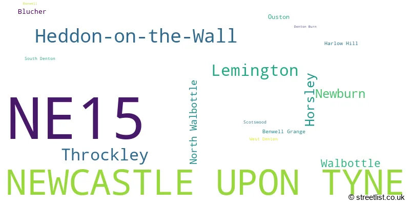
The largest settlement in the NE15 postal code is NEWCASTLE UPON TYNE followed by Heddon-on-the-Wall, and Lemington.
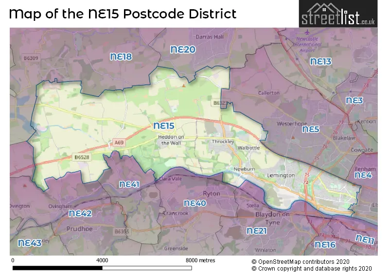
The NE15 Postcode shares a border with NE42 (PRUDHOE, Ovingham, Ovington), NE21 (BLAYDON-ON-TYNE, Winlaton Mill, Winlaton), NE4 (NEWCASTLE UPON TYNE, Fenham), NE41 (WYLAM), NE5 (NEWCASTLE UPON TYNE, Callerton, Westerhope), NE18 (Stamfordham, Dalton, Eachwick) and NE20 (Ponteland, Belsay, Matfen).
The primary settlement in the NE15 postcode district is Newcastle upon Tyne, located in the county of Northumberland. Newcastle upon Tyne is also the main post town for this postcode district. Other significant settlements in the NE15 district include Heddon-on-the-Wall, Horsley, Ouston, and Throckley, all within the county of Northumberland.
For the district NE15, we have data on 5 postcode sectors. Here's a breakdown: The sector NE15 0, covers Heddon-On-The-Wall and Horsley in Northumberland. The sector NE15 6, covers Newcastle Upon Tyne in Tyne & Wear. The sector NE15 7, covers Newcastle Upon Tyne in Tyne & Wear. The sector NE15 8, covers Newcastle Upon Tyne and Lemington in Tyne & Wear. The sector NE15 9, covers Newcastle Upon Tyne and Throckley in Tyne & Wear.

Map of the NE15 Postcode District
Explore the NE15 postcode district by using our free interactive map.
When it comes to local government, postal geography often disregards political borders. However, for a breakdown in the NE15 District: the district mostly encompasses the Newcastle upon Tyne District (B) (798 postcodes), and finally, the Northumberland area (93 postcodes).
Recent House Sales in NE15
| Date | Price | Address |
|---|---|---|
| 13/10/2023 | £255,000 | Hexham Road, Newcastle Upon Tyne, NE15 9DU |
| 12/10/2023 | £200,000 | Willowford Place, Newcastle Upon Tyne, NE15 6DZ |
| 13/09/2023 | £136,000 | Pendower Way, Newcastle Upon Tyne, NE15 6SN |
| 08/09/2023 | £65,000 | Montague Street, Lemington, Newcastle Upon Tyne, NE15 8RY |
| 06/09/2023 | £249,950 | Norton Way, Newcastle Upon Tyne, NE15 7QU |
| 05/09/2023 | £275,000 | Marius Avenue, Heddon On The Wall, Newcastle Upon Tyne, NE15 0EB |
| 31/08/2023 | £278,000 | Baroness Drive, Newcastle Upon Tyne, NE15 7AU |
| 31/08/2023 | £270,000 | North Farm Court, Throckley, Newcastle Upon Tyne, NE15 9DW |
| 31/08/2023 | £109,000 | Hewley Crescent, Newcastle Upon Tyne, NE15 9AT |
| 25/08/2023 | £135,000 | Lydney Court, Throckley, Newcastle Upon Tyne, NE15 9QP |
Weather Forecast for NE15
Press Button to Show Forecast for Throckley
| Time Period | Icon | Description | Temperature | Rain Probability | Wind |
|---|---|---|---|---|---|
| 06:00 to 09:00 | Cloudy | 3.0°C (feels like 0.0°C) | 9.00% | NW 4 mph | |
| 09:00 to 12:00 | Cloudy | 6.0°C (feels like 4.0°C) | 12.00% | NNE 4 mph | |
| 12:00 to 15:00 | Cloudy | 7.0°C (feels like 5.0°C) | 27.00% | E 4 mph | |
| 15:00 to 18:00 | Overcast | 7.0°C (feels like 6.0°C) | 10.00% | ENE 7 mph | |
| 18:00 to 21:00 | Partly cloudy (day) | 7.0°C (feels like 5.0°C) | 5.00% | E 7 mph | |
| 21:00 to 00:00 | Partly cloudy (night) | 3.0°C (feels like 1.0°C) | 2.00% | ESE 4 mph |
Press Button to Show Forecast for Throckley
| Time Period | Icon | Description | Temperature | Rain Probability | Wind |
|---|---|---|---|---|---|
| 00:00 to 03:00 | Clear night | 3.0°C (feels like 1.0°C) | 2.00% | S 4 mph | |
| 03:00 to 06:00 | Partly cloudy (night) | 2.0°C (feels like 0.0°C) | 4.00% | SW 2 mph | |
| 06:00 to 09:00 | Sunny day | 3.0°C (feels like 2.0°C) | 6.00% | S 2 mph | |
| 09:00 to 12:00 | Cloudy | 7.0°C (feels like 5.0°C) | 11.00% | ESE 7 mph | |
| 12:00 to 15:00 | Cloudy | 9.0°C (feels like 7.0°C) | 15.00% | ESE 7 mph | |
| 15:00 to 18:00 | Cloudy | 8.0°C (feels like 6.0°C) | 13.00% | E 9 mph | |
| 18:00 to 21:00 | Partly cloudy (day) | 8.0°C (feels like 5.0°C) | 9.00% | E 9 mph | |
| 21:00 to 00:00 | Cloudy | 5.0°C (feels like 3.0°C) | 13.00% | E 7 mph |
Press Button to Show Forecast for Throckley
| Time Period | Icon | Description | Temperature | Rain Probability | Wind |
|---|---|---|---|---|---|
| 00:00 to 03:00 | Cloudy | 5.0°C (feels like 2.0°C) | 15.00% | NE 7 mph | |
| 03:00 to 06:00 | Overcast | 5.0°C (feels like 2.0°C) | 18.00% | NE 9 mph | |
| 06:00 to 09:00 | Overcast | 6.0°C (feels like 3.0°C) | 21.00% | NE 11 mph | |
| 09:00 to 12:00 | Light rain | 7.0°C (feels like 4.0°C) | 51.00% | NNE 13 mph | |
| 12:00 to 15:00 | Heavy rain | 8.0°C (feels like 5.0°C) | 74.00% | NNE 13 mph | |
| 15:00 to 18:00 | Light rain | 8.0°C (feels like 5.0°C) | 55.00% | N 11 mph | |
| 18:00 to 21:00 | Heavy rain | 9.0°C (feels like 7.0°C) | 71.00% | N 7 mph | |
| 21:00 to 00:00 | Partly cloudy (night) | 6.0°C (feels like 4.0°C) | 10.00% | SE 7 mph |
Where is the NE15 Postcode District?
The postcode district NE15 is located in the town of Newcastle Upon Tyne. It is in close proximity to several nearby towns. To the South West is Wylam, which is approximately 1.92 miles away. To the South is Ryton, which is approximately 2.04 miles away. To the South East is Blaydon-on-Tyne, which is approximately 3.67 miles away. To the West is Corbridge, which is approximately 8.36 miles away. The distance from NE15 to the center of London is approximately 250.84 miles.
The district is within the post town of NEWCASTLE UPON TYNE.
The sector has postcodes within the nation of England.
The NE15 Postcode District is covers the following regions.
- Northumberland - Northumberland and Tyne and Wear - North East (England)
- Tyneside - Northumberland and Tyne and Wear - North East (England)
| Postcode Sector | Delivery Office |
|---|---|
| NE15 0 | West Delivery Office (ne) |
| NE15 6 | West Delivery Office (ne) |
| NE15 7 | West Delivery Office (ne) |
| NE15 8 | West Delivery Office (ne) |
| NE15 9 | West Delivery Office (ne) |
| N | E | 1 | 5 | - | X | X | X |
| N | E | 1 | 5 | Space | Numeric | Letter | Letter |
Current Monthly Rental Prices
| # Bedrooms | Min Price | Max Price | Avg Price |
|---|---|---|---|
| £400 | £3,000 | £1,700 | |
| 2 | £650 | £950 | £800 |
| 3 | £850 | £1,500 | £1,136 |
| 4 | £1,250 | £3,000 | £2,075 |
| 5 | £1,950 | £1,950 | £1,950 |
Current House Prices
| # Bedrooms | Min Price | Max Price | Avg Price |
|---|---|---|---|
| 1 | £49,950 | £110,000 | £67,483 |
| 2 | £50,000 | £260,000 | £125,690 |
| 3 | £70,000 | £450,000 | £209,902 |
| 4 | £105,000 | £1,350,000 | £400,437 |
| 5 | £415,000 | £1,200,000 | £669,713 |
| 6 | £695,000 | £695,000 | £695,000 |
Estate Agents who Operate in the NE15 District
| Logo | Name | Brand Name | Address | Contact Number | Total Properties |
|---|---|---|---|---|---|
 | West Denton | Rook Matthews Sayer | 120 Roman Way, West Denton, Newcastle Upon Tyne, NE5 5AD | 0191 625 0217 | 16 |
 | West Denton | YOUR MOVE Chris Stonock | 130 The Roman Way, West Denton, Newcastle Upon Tyne, NE5 5AD | 0191 625 0263 | 15 |
 | Newcastle | Northwood incorporating Bowes Mitchell | 676 West Road, Denton Burn, Newcastle Upon Tyne, NE5 2UR | 0191 625 0777 | 10 |
 | West Road | Pattinson Estate Agents | 158 West Road, Fenham, Newcastle Upon Tyne, NE4 9QB | 0191 625 0225 | 8 |
 | Corbridge | Finest Properties | Crossways, Market Place, Corbridge NE45 5AW | 01434 409033 | 6 |
| Type of Property | 2018 Average | 2018 Sales | 2017 Average | 2017 Sales | 2016 Average | 2016 Sales | 2015 Average | 2015 Sales |
|---|---|---|---|---|---|---|---|---|
| Detached | £302,548 | 60 | £250,398 | 64 | £225,110 | 56 | £212,557 | 72 |
| Semi-Detached | £138,921 | 184 | £138,672 | 229 | £132,078 | 200 | £135,606 | 203 |
| Terraced | £115,516 | 157 | £109,187 | 165 | £122,799 | 176 | £114,099 | 160 |
| Flats | £77,982 | 55 | £68,534 | 44 | £69,580 | 53 | £63,772 | 51 |