The NG15 postcode district is a postal district located in the NG Nottingham postcode area with a population of 45,726 residents according to the 2021 England and Wales Census.
The area of the NG15 postcode district is 20.88 square miles which is 54.09 square kilometres or 13,365.05 acres.
Currently, the NG15 district has about 980 postcode units spread across 5 geographic postcode sectors.
Given that each sector allows for 400 unique postcode combinations, the district has a capacity of 2,000 postcodes. With 980 postcodes already in use, this leaves 1020 units available.
The largest settlement in the NG15 postal code is Hucknall followed by Ravenshead, and Annesley.
The NG15 Postcode shares a border with NG16 (Eastwood, Selston, Langley Mill), NG17 (SUTTON-IN-ASHFIELD, Kirkby-in-Ashfield, Huthwaite), NG21 (Rainworth, Edwinstowe, Clipstone Village), NG18 (MANSFIELD) and NG6 (NOTTINGHAM, Bestwood Village, Bulwell).
The primary settlement in the NG15 postcode district is Hucknall, located in Nottinghamshire. Other significant settlements in the district include Ravenshead, Annesley, Newstead Village, Linby, and Papplewick. The most significant post town in the district is Nottingham.
For the district NG15, we have data on 6 postcode sectors. Here's a breakdown: The sector NG15 0, covers Annesley and Newstead Village in Nottinghamshire. The sector NG15 5 is non-geographic. It's often designated for PO Boxes, large organisations, or special services. The sector NG15 6, covers Hucknall in Nottinghamshire. The sector NG15 7, covers Hucknall in Nottinghamshire. The sector NG15 8, covers Hucknall and Linby and Papplewick in Nottinghamshire. The sector NG15 9, covers Ravenshead in Nottinghamshire.

Map of the NG15 Postcode District
Explore the NG15 postcode district by using our free interactive map.
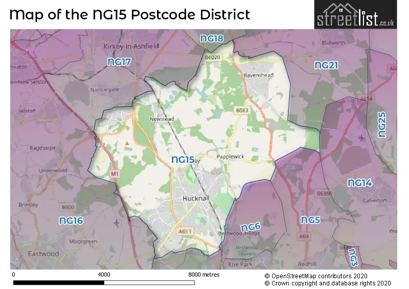
When it comes to local government, postal geography often disregards political borders. However, for a breakdown in the NG15 District: the district mostly encompasses the Ashfield District (802 postcodes), and finally, the Gedling District (B) area (199 postcodes).
Recent House Sales in NG15
| Date | Price | Address |
|---|---|---|
| 12/10/2023 | £290,000 | Chapel Fields, Ravenshead, Nottingham, NG15 9DT |
| 10/10/2023 | £247,500 | Blacksmiths Court, Papplewick, Nottingham, NG15 8FZ |
| 03/10/2023 | £380,000 | Vernon Crescent, Ravenshead, Nottingham, NG15 9BL |
| 02/10/2023 | £120,000 | Laxton Drive, Hucknall, Nottingham, NG15 6PU |
| 29/09/2023 | £300,000 | Bolingey Way, Hucknall, Nottingham, NG15 6TQ |
| 29/09/2023 | £155,000 | Watnall Road, Hucknall, Nottingham, NG15 6FB |
| 26/09/2023 | £460,000 | South View Gardens, Ravenshead, Nottingham, NG15 9GB |
| 19/09/2023 | £145,000 | Byron Road, Annesley, Nottingham, NG15 0AH |
| 11/09/2023 | £90,000 | Broomhill Road, Hucknall, Nottingham, NG15 6AD |
| 11/09/2023 | £90,000 | Balmoral Grove, Hucknall, Nottingham, NG15 8ES |
Weather Forecast for NG15
Press Button to Show Forecast for Newstead Abbey
| Time Period | Icon | Description | Temperature | Rain Probability | Wind |
|---|---|---|---|---|---|
| 09:00 to 12:00 | Partly cloudy (day) | 6.0°C (feels like 5.0°C) | 2.00% | NE 7 mph | |
| 12:00 to 15:00 | Cloudy | 9.0°C (feels like 8.0°C) | 9.00% | ENE 4 mph | |
| 15:00 to 18:00 | Cloudy | 9.0°C (feels like 8.0°C) | 7.00% | ENE 4 mph | |
| 18:00 to 21:00 | Cloudy | 7.0°C (feels like 5.0°C) | 10.00% | ENE 9 mph | |
| 21:00 to 00:00 | Cloudy | 5.0°C (feels like 3.0°C) | 10.00% | ENE 7 mph |
Press Button to Show Forecast for Newstead Abbey
| Time Period | Icon | Description | Temperature | Rain Probability | Wind |
|---|---|---|---|---|---|
| 00:00 to 03:00 | Partly cloudy (night) | 4.0°C (feels like 2.0°C) | 8.00% | NE 4 mph | |
| 03:00 to 06:00 | Cloudy | 3.0°C (feels like 1.0°C) | 11.00% | NE 4 mph | |
| 06:00 to 09:00 | Cloudy | 4.0°C (feels like 1.0°C) | 10.00% | NE 7 mph | |
| 09:00 to 12:00 | Cloudy | 7.0°C (feels like 5.0°C) | 12.00% | ENE 9 mph | |
| 12:00 to 15:00 | Cloudy | 9.0°C (feels like 7.0°C) | 19.00% | ENE 9 mph | |
| 15:00 to 18:00 | Cloudy | 10.0°C (feels like 8.0°C) | 19.00% | ENE 11 mph | |
| 18:00 to 21:00 | Cloudy | 9.0°C (feels like 6.0°C) | 19.00% | ENE 11 mph | |
| 21:00 to 00:00 | Cloudy | 7.0°C (feels like 4.0°C) | 17.00% | NE 11 mph |
Press Button to Show Forecast for Newstead Abbey
| Time Period | Icon | Description | Temperature | Rain Probability | Wind |
|---|---|---|---|---|---|
| 00:00 to 03:00 | Overcast | 6.0°C (feels like 3.0°C) | 24.00% | NE 11 mph | |
| 03:00 to 06:00 | Light rain | 6.0°C (feels like 3.0°C) | 51.00% | NNE 13 mph | |
| 06:00 to 09:00 | Heavy rain | 7.0°C (feels like 3.0°C) | 76.00% | NNE 13 mph | |
| 09:00 to 12:00 | Heavy rain | 8.0°C (feels like 5.0°C) | 77.00% | NNE 13 mph | |
| 12:00 to 15:00 | Heavy rain | 10.0°C (feels like 7.0°C) | 77.00% | NNE 13 mph | |
| 15:00 to 18:00 | Light rain | 10.0°C (feels like 7.0°C) | 46.00% | N 11 mph | |
| 18:00 to 21:00 | Light rain shower (day) | 9.0°C (feels like 7.0°C) | 39.00% | N 9 mph | |
| 21:00 to 00:00 | Partly cloudy (night) | 8.0°C (feels like 6.0°C) | 9.00% | SE 7 mph |
Where is the NG15 Postcode District?
The postcode district NG15 is located in Nottingham. It is nearby towns such as Mansfield (5.44 miles to the north), Sutton-in-Ashfield (5.68 miles to the northwest), Heanor (7.03 miles to the southwest), Alfreton (8.61 miles to the west), and Southwell (9.67 miles to the east). Additionally, NG15 is approximately 116.50 miles away from the centre of London.
The district is within the post town of NOTTINGHAM.
The sector has postcodes within the nation of England.
The NG15 Postcode District is covers the following regions.
- North Nottinghamshire - Derbyshire and Nottinghamshire - East Midlands (England)
- South Nottinghamshire - Derbyshire and Nottinghamshire - East Midlands (England)
| Postcode Sector | Delivery Office |
|---|---|
| NG15 0 | Hucknall Delivery Office |
| NG15 6 | Hucknall Delivery Office |
| NG15 7 | Hucknall Delivery Office |
| NG15 8 | Hucknall Delivery Office |
| NG15 9 | Ravenshead Scale Payment Delivery Office |
| N | G | 1 | 5 | - | X | X | X |
| N | G | 1 | 5 | Space | Numeric | Letter | Letter |
Tourist Attractions within the Postcode Area
We found 1 visitor attractions within the NG15 postcode area
| Newstead Abbey |
|---|
| Museums & Art Galleries |
| Museum and / or Art Gallery |
| View Newstead Abbey on Google Maps |
Current Monthly Rental Prices
| # Bedrooms | Min Price | Max Price | Avg Price |
|---|---|---|---|
| £850 | £850 | £850 | |
| 1 | £495 | £625 | £532 |
| 2 | £695 | £1,200 | £829 |
| 3 | £750 | £1,500 | £1,081 |
| 4 | £1,295 | £3,500 | £1,927 |
Current House Prices
| # Bedrooms | Min Price | Max Price | Avg Price |
|---|---|---|---|
| £75,000 | £2,400,000 | £939,167 | |
| 1 | £180,000 | £180,000 | £180,000 |
| 2 | £115,000 | £450,000 | £195,000 |
| 3 | £125,000 | £900,000 | £275,054 |
| 4 | £130,000 | £1,150,000 | £431,304 |
| 5 | £325,000 | £1,295,000 | £670,043 |
| 6 | £230,000 | £1,000,000 | £611,000 |
| 7 | £1,100,000 | £1,500,000 | £1,300,000 |
| 13 | £800,000 | £800,000 | £800,000 |
| 24 | £1,400,000 | £1,400,000 | £1,400,000 |
Estate Agents who Operate in the NG15 District
| Logo | Name | Brand Name | Address | Contact Number | Total Properties |
|---|---|---|---|---|---|
 | Hucknall | HoldenCopley | 33A High Street, Hucknall, Nottingham, NG15 7HJ | 0115 647 9661 | 56 |
 | Hucknall | Bairstow Eves | 19 High Street Hucknall Nottingham NG15 7HJ | 0115 647 0972 | 35 |
 | Hucknall | haart | 34a High Street, Hucknall, Nottingham, NG15 7HG | 0115 647 3690 | 35 |
 | Ravenshead | Gascoines | 2a Milton Court, Ravenshead, NG15 9BD | 01623 700883 | 30 |
 | Hucknall | Burchell Edwards | 64 High Street, Hucknall, Nottingham, NG15 7AX | 0115 647 6329 | 24 |
| Type of Property | 2018 Average | 2018 Sales | 2017 Average | 2017 Sales | 2016 Average | 2016 Sales | 2015 Average | 2015 Sales |
|---|---|---|---|---|---|---|---|---|
| Detached | £281,815 | 348 | £272,074 | 396 | £250,905 | 491 | £239,767 | 331 |
| Semi-Detached | £151,326 | 278 | £147,653 | 348 | £141,910 | 355 | £131,720 | 255 |
| Terraced | £127,995 | 239 | £128,334 | 294 | £113,878 | 285 | £112,266 | 274 |
| Flats | £110,782 | 31 | £124,981 | 49 | £124,816 | 97 | £96,607 | 29 |