The NN13 postcode district is a postal district located in the NN Northampton postcode area with a population of 21,978 residents according to the 2021 England and Wales Census.
The area of the NN13 postcode district is 51.91 square miles which is 134.45 square kilometres or 33,222.52 acres.
Currently, the NN13 district has about 562 postcode units spread across 3 geographic postcode sectors.
Given that each sector allows for 400 unique postcode combinations, the district has a capacity of 1,200 postcodes. With 562 postcodes already in use, this leaves 638 units available.
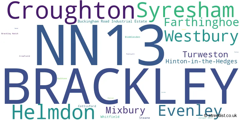
The largest settlement in the NN13 postal code is BRACKLEY followed by Croughton, and Helmdon.
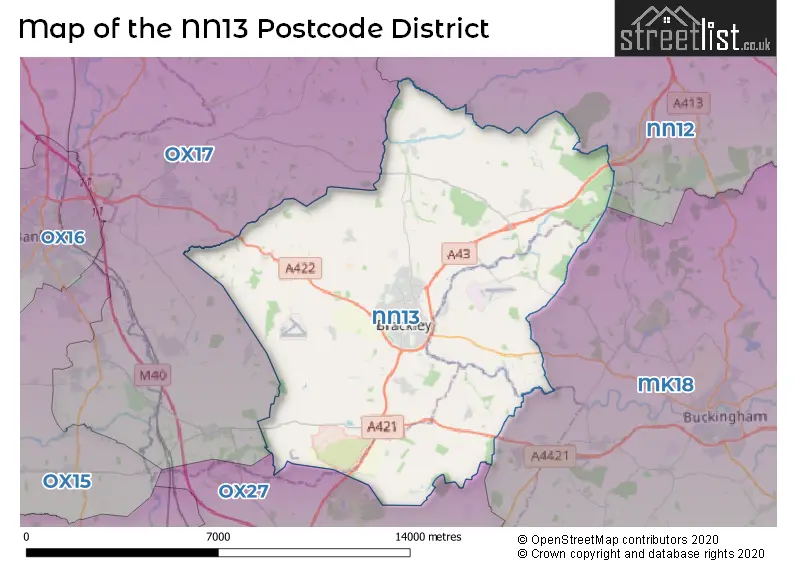
The NN13 Postcode shares a border with OX17 (Middleton Cheney, Adderbury, Kings Sutton), OX27 (BICESTER, Marsh Gibbon, Caversfield), NN12 (TOWCESTER, Silverstone, Potterspury) and MK18 (BUCKINGHAM, Winslow, Steeple Claydon).
In the NN13 postcode district, the primary settlement is Brackley, located in the county of Northamptonshire, England. Other significant settlements in this district include Biddlesden and Cottisford in Buckinghamshire, Croughton and Crowfield in Northamptonshire, and Evenley and Helmdon in Oxfordshire. The most significant post town in this district is Brackley.
For the district NN13, we have data on 4 postcode sectors. Here's a breakdown: The sector NN13 5, covers Croughton and Syresham and Helmdon in Northamptonshire. The sector NN13 5, covers Westbury in Buckinghamshire. The sector NN13 6, covers Brackley in Northamptonshire. The sector NN13 7, covers Brackley in Northamptonshire. The sector NN13 9 is non-geographic. It's often designated for PO Boxes, large organisations, or special services.

Map of the NN13 Postcode District
Explore the NN13 postcode district by using our free interactive map.
When it comes to local government, postal geography often disregards political borders. However, for a breakdown in the NN13 District: the district mostly encompasses the West Northamptonshire (511 postcodes), followed by the Buckinghamshire area (34 postcodes), and finally, the Cherwell District area (20 postcodes).
Recent House Sales in NN13
| Date | Price | Address |
|---|---|---|
| 20/10/2023 | £183,000 | Johnson Avenue, Brackley, NN13 6JF |
| 12/10/2023 | £249,000 | Halse Road, Brackley, NN13 6EG |
| 12/10/2023 | £380,000 | Valley Road, Brackley, NN13 7DQ |
| 11/10/2023 | £495,000 | Brewin Close, Brackley, NN13 6NX |
| 11/10/2023 | £350,000 | Poppyfields Way, Brackley, NN13 6GB |
| 10/10/2023 | £312,500 | Manor Road, Brackley, NN13 6AJ |
| 29/09/2023 | £537,500 | Main Street, Westbury, Brackley, NN13 5JR |
| 15/09/2023 | £470,000 | High Street, Croughton, Brackley, NN13 5LT |
| 13/09/2023 | £247,000 | Roman Way, Brackley, NN13 7JA |
| 13/09/2023 | £525,000 | Portia Lane, Brackley, NN13 6FT |
Weather Forecast for NN13
Press Button to Show Forecast for Brackley
| Time Period | Icon | Description | Temperature | Rain Probability | Wind |
|---|---|---|---|---|---|
| 06:00 to 09:00 | Cloudy | 3.0°C (feels like 0.0°C) | 4.00% | NE 7 mph | |
| 09:00 to 12:00 | Cloudy | 7.0°C (feels like 4.0°C) | 5.00% | ENE 7 mph | |
| 12:00 to 15:00 | Cloudy | 9.0°C (feels like 8.0°C) | 9.00% | ENE 7 mph | |
| 15:00 to 18:00 | Overcast | 9.0°C (feels like 8.0°C) | 12.00% | NE 4 mph | |
| 18:00 to 21:00 | Cloudy | 9.0°C (feels like 7.0°C) | 11.00% | NE 4 mph | |
| 21:00 to 00:00 | Cloudy | 5.0°C (feels like 3.0°C) | 12.00% | ENE 7 mph |
Press Button to Show Forecast for Brackley
| Time Period | Icon | Description | Temperature | Rain Probability | Wind |
|---|---|---|---|---|---|
| 00:00 to 03:00 | Cloudy | 4.0°C (feels like 2.0°C) | 12.00% | ENE 7 mph | |
| 03:00 to 06:00 | Cloudy | 3.0°C (feels like 1.0°C) | 14.00% | ENE 7 mph | |
| 06:00 to 09:00 | Overcast | 4.0°C (feels like 1.0°C) | 19.00% | NE 9 mph | |
| 09:00 to 12:00 | Cloudy | 7.0°C (feels like 4.0°C) | 19.00% | ENE 9 mph | |
| 12:00 to 15:00 | Overcast | 10.0°C (feels like 7.0°C) | 22.00% | ENE 11 mph | |
| 15:00 to 18:00 | Overcast | 11.0°C (feels like 8.0°C) | 22.00% | ENE 11 mph | |
| 18:00 to 21:00 | Light rain | 9.0°C (feels like 7.0°C) | 52.00% | NE 11 mph | |
| 21:00 to 00:00 | Light rain | 7.0°C (feels like 4.0°C) | 52.00% | NE 13 mph |
Press Button to Show Forecast for Brackley
| Time Period | Icon | Description | Temperature | Rain Probability | Wind |
|---|---|---|---|---|---|
| 00:00 to 03:00 | Light rain | 7.0°C (feels like 3.0°C) | 52.00% | NE 11 mph | |
| 03:00 to 06:00 | Heavy rain | 7.0°C (feels like 4.0°C) | 77.00% | NE 11 mph | |
| 06:00 to 09:00 | Heavy rain | 7.0°C (feels like 5.0°C) | 76.00% | NE 9 mph | |
| 09:00 to 12:00 | Light rain | 9.0°C (feels like 7.0°C) | 50.00% | E 9 mph | |
| 12:00 to 15:00 | Light rain shower (day) | 11.0°C (feels like 8.0°C) | 46.00% | WSW 9 mph | |
| 15:00 to 18:00 | Light rain | 10.0°C (feels like 8.0°C) | 53.00% | W 11 mph | |
| 18:00 to 21:00 | Light rain shower (day) | 9.0°C (feels like 7.0°C) | 38.00% | W 11 mph | |
| 21:00 to 00:00 | Clear night | 7.0°C (feels like 5.0°C) | 7.00% | WSW 7 mph |
Where is the NN13 Postcode District?
The data shows that the postcode district NN13 is located in the town of Brackley. Brackley is situated in close proximity to several nearby towns, with Banbury to the west, Buckingham to the south east, Towcester to the north east, Bicester to the south, Daventry to the north, Woodstock to the south west, and Southam to the north west. Additionally, Brackley is located approximately 56.98 miles away from the center of London.
The district is within the post town of BRACKLEY.
The sector has postcodes within the nation of England.
The NN13 Postcode District is covers the following regions.
- West Northamptonshire - Leicestershire, Rutland and Northamptonshire - East Midlands (England)
- Oxfordshire - Berkshire, Buckinghamshire and Oxfordshire - South East (England)
| Postcode Sector | Delivery Office |
|---|---|
| NN13 5 | Brackley Delivery Office |
| NN13 6 | Brackley Delivery Office |
| NN13 7 | Brackley Delivery Office |
| N | N | 1 | 3 | - | X | X | X |
| N | N | 1 | 3 | Space | Numeric | Letter | Letter |
Current Monthly Rental Prices
| # Bedrooms | Min Price | Max Price | Avg Price |
|---|---|---|---|
| 1 | £750 | £875 | £808 |
| 5 | £3,000 | £3,000 | £3,000 |
Current House Prices
| # Bedrooms | Min Price | Max Price | Avg Price |
|---|---|---|---|
| £140,000 | £800,000 | £394,999 | |
| 1 | £99,950 | £199,950 | £145,758 |
| 2 | £108,750 | £465,000 | £271,385 |
| 3 | £265,000 | £650,000 | £368,481 |
| 4 | £359,950 | £1,250,000 | £529,434 |
| 5 | £500,000 | £1,100,000 | £716,429 |
| 6 | £650,000 | £1,195,000 | £843,333 |
| 7 | £750,000 | £1,599,999 | £1,175,000 |
| 11 | £9,000,000 | £9,000,000 | £9,000,000 |
Estate Agents who Operate in the NN13 District
| Logo | Name | Brand Name | Address | Contact Number | Total Properties |
|---|---|---|---|---|---|
 | Brackley | Alexander & Co | 29 Market Place, Brackley, NN13 7AB | 01280 733214 | 48 |
 | Brackley | Davies & Partners | 12 Market Place, Brackley, NN13 7DP | 01280 733283 | 34 |
 | Brackley | Boughtons Family Run Estate Agents | 44 Market Place Brackley NN13 7AB | 01280 733246 | 20 |
 | Birmingham | Fine & Country | 83-85 Hagley Road, Birmingham, B16 8QG | 0121 387 6323 | 5 |
 | Banbury | Hamptons Sales | 44 Market Place, Banbury, OX16 8NW | 01295 230582 | 4 |
| Type of Property | 2018 Average | 2018 Sales | 2017 Average | 2017 Sales | 2016 Average | 2016 Sales | 2015 Average | 2015 Sales |
|---|---|---|---|---|---|---|---|---|
| Detached | £398,082 | 224 | £401,718 | 254 | £383,789 | 297 | £378,925 | 232 |
| Semi-Detached | £280,725 | 128 | £268,404 | 133 | £261,906 | 153 | £248,511 | 118 |
| Terraced | £265,772 | 119 | £246,108 | 157 | £236,449 | 122 | £210,881 | 93 |
| Flats | £172,034 | 51 | £167,438 | 52 | £158,569 | 39 | £166,758 | 40 |