The NR11 postcode district is a postal district located in the NR Norwich postcode area with a population of 19,182 residents according to the 2021 England and Wales Census.
The area of the NR11 postcode district is 84.13 square miles which is 217.90 square kilometres or 53,843.03 acres.
Currently, the NR11 district has about 772 postcode units spread across 3 geographic postcode sectors.
Given that each sector allows for 400 unique postcode combinations, the district has a capacity of 1,200 postcodes. With 772 postcodes already in use, this leaves 428 units available.
The largest settlement in the NR11 postal code is Aylsham followed by Mundesley, and Southrepps.
The postcode area has a boundary with The North Sea.
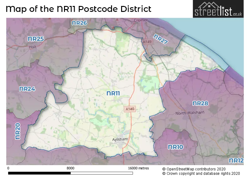
The NR11 Postcode shares a border with NR25 (HOLT, Blakeney, Weybourne), NR26 (SHERINGHAM, Beeston Regis, Upper Sheringham), NR10 (Horsford, Spixworth, Reepham), NR28 (NORTH WALSHAM, Trunch, Worstead), NR20 (DEREHAM, Mattishall, Swanton Morley), NR24 (Briston, MELTON CONSTABLE, Edgefield) and NR27 (CROMER, Overstrand, West Runton).
The primary settlement in the NR11 postcode district is Aylsham, located in the county of Norfolk, England. Other significant settlements include Blickling, Burgh, Corpusty, Heydon, Ingworth, Oulton, Tuttington, and Wood Dalling, all of which are also located in Norfolk. The main post town in this postcode district is Norwich.
For the district NR11, we have data on 3 postcode sectors. Here's a breakdown: The sector NR11 6, covers Aylsham in Norfolk. The sector NR11 7, covers Erpingham in Norfolk. The sector NR11 8, covers Mundesley and Southrepps and Roughton in Norfolk.

Map of the NR11 Postcode District
Explore the NR11 postcode district by using our free interactive map.
When it comes to local government, postal geography often disregards political borders. However, for a breakdown in the NR11 District: the district mostly encompasses the North Norfolk District (489 postcodes), and finally, the Broadland District area (286 postcodes).
Recent House Sales in NR11
| Date | Price | Address |
|---|---|---|
| 19/10/2023 | £245,000 | John Ogaunt Close, Aylsham, Norwich, NR11 6DG |
| 18/10/2023 | £408,000 | The Maltings, Aylsham, Norwich, NR11 6GX |
| 18/10/2023 | £587,500 | East Beckham, Norwich, NR11 8RP |
| 13/10/2023 | £125,000 | Manor Court, Aylsham, Norwich, NR11 6LF |
| 10/10/2023 | £415,000 | Bridge Road, Colby, Norwich, NR11 7EA |
| 09/10/2023 | £332,500 | Tuddenham Road, Aylsham, Norwich, NR11 6DF |
| 04/10/2023 | £335,000 | Banningham Road, Aylsham, Norwich, NR11 6LS |
| 04/10/2023 | £360,000 | Orchard Close, Mundesley, Norwich, NR11 8AZ |
| 02/10/2023 | £340,000 | Aegel Gardens, Aylsham, Norwich, NR11 6GQ |
| 29/09/2023 | £215,000 | Jubilee Close, Erpingham, Norwich, NR11 7QZ |
Weather Forecast for NR11
Press Button to Show Forecast for Mannington Hall
| Time Period | Icon | Description | Temperature | Rain Probability | Wind |
|---|---|---|---|---|---|
| 06:00 to 09:00 | Cloudy | 4.0°C (feels like 3.0°C) | 8.00% | NW 4 mph | |
| 09:00 to 12:00 | Cloudy | 8.0°C (feels like 6.0°C) | 5.00% | NNE 7 mph | |
| 12:00 to 15:00 | Cloudy | 9.0°C (feels like 7.0°C) | 10.00% | NE 9 mph | |
| 15:00 to 18:00 | Cloudy | 9.0°C (feels like 7.0°C) | 10.00% | ENE 9 mph | |
| 18:00 to 21:00 | Cloudy | 8.0°C (feels like 6.0°C) | 5.00% | ENE 7 mph | |
| 21:00 to 00:00 | Partly cloudy (night) | 4.0°C (feels like 2.0°C) | 3.00% | ENE 7 mph |
Press Button to Show Forecast for Mannington Hall
| Time Period | Icon | Description | Temperature | Rain Probability | Wind |
|---|---|---|---|---|---|
| 00:00 to 03:00 | Partly cloudy (night) | 3.0°C (feels like 1.0°C) | 6.00% | NE 4 mph | |
| 03:00 to 06:00 | Cloudy | 3.0°C (feels like 1.0°C) | 10.00% | NE 7 mph | |
| 06:00 to 09:00 | Cloudy | 6.0°C (feels like 4.0°C) | 10.00% | ENE 7 mph | |
| 09:00 to 12:00 | Cloudy | 9.0°C (feels like 7.0°C) | 17.00% | ENE 9 mph | |
| 12:00 to 15:00 | Overcast | 11.0°C (feels like 8.0°C) | 18.00% | ENE 9 mph | |
| 15:00 to 18:00 | Overcast | 11.0°C (feels like 9.0°C) | 16.00% | ENE 11 mph | |
| 18:00 to 21:00 | Cloudy | 10.0°C (feels like 7.0°C) | 11.00% | ENE 11 mph | |
| 21:00 to 00:00 | Cloudy | 8.0°C (feels like 6.0°C) | 18.00% | ENE 11 mph |
Press Button to Show Forecast for Mannington Hall
| Time Period | Icon | Description | Temperature | Rain Probability | Wind |
|---|---|---|---|---|---|
| 00:00 to 03:00 | Light rain | 9.0°C (feels like 6.0°C) | 50.00% | ENE 11 mph | |
| 03:00 to 06:00 | Light rain | 9.0°C (feels like 7.0°C) | 49.00% | E 9 mph | |
| 06:00 to 09:00 | Light rain shower (day) | 10.0°C (feels like 8.0°C) | 43.00% | SE 11 mph | |
| 09:00 to 12:00 | Light rain shower (day) | 12.0°C (feels like 10.0°C) | 38.00% | SSE 13 mph | |
| 12:00 to 15:00 | Light rain shower (day) | 13.0°C (feels like 10.0°C) | 41.00% | SSE 16 mph | |
| 15:00 to 18:00 | Light rain shower (day) | 13.0°C (feels like 10.0°C) | 42.00% | SSW 13 mph | |
| 18:00 to 21:00 | Light rain shower (day) | 11.0°C (feels like 9.0°C) | 34.00% | SW 11 mph | |
| 21:00 to 00:00 | Partly cloudy (night) | 9.0°C (feels like 6.0°C) | 3.00% | SW 9 mph |
Where is the NR11 Postcode District?
The postcode district NR11 is located in the town of Norwich, which is the district town. It is surrounded by nearby towns including Cromer to the north (5.78 miles away), North Walsham to the east (6.94 miles away), Holt to the northwest (7.91 miles away), Melton Constable to the west (8.98 miles away), and Dereham to the southwest (16.68 miles away). Additionally, the town is approximately 109.23 miles away from the center of London.
The district is within the post town of NORWICH.
The sector has postcodes within the nation of England.
The NR11 Postcode District is covers the following regions.
- Norwich and East Norfolk - East Anglia - East of England
- North and West Norfolk - East Anglia - East of England
| Postcode Sector | Delivery Office |
|---|---|
| NR11 6 | Aylsham Scale Payment Delivery Office |
| NR11 7 | Aylsham Scale Payment Delivery Office |
| NR11 7 | Sheringham Delivery Office |
| NR11 8 | Sheringham Delivery Office |
| NR11 8 | Mundesley Scale Payment Delivery Office |
| N | R | 1 | 1 | - | X | X | X |
| N | R | 1 | 1 | Space | Numeric | Letter | Letter |
Tourist Attractions within the Postcode Area
We found 4 visitor attractions within the NR11 postcode area
| Mannington Gardens |
|---|
| Historic Properties |
| Historic House / House and Garden / Palace |
| View Mannington Gardens on Google Maps |
| Blickling Hall, Gardens and Park |
| Historic Properties |
| Historic House / House and Garden / Palace |
| View Blickling Hall, Gardens and Park on Google Maps |
| Redwings Aylsham |
| Farms |
| Farm / Rare Breeds / Farm Animals |
| View Redwings Aylsham on Google Maps |
| Felbrigg Hall, Garden and Park |
| Historic Properties |
| Historic House / House and Garden / Palace |
| View Felbrigg Hall, Garden and Park on Google Maps |
Current Monthly Rental Prices
| # Bedrooms | Min Price | Max Price | Avg Price |
|---|---|---|---|
| 2 | £625 | £795 | £713 |
| 3 | £875 | £1,600 | £1,125 |
| 4 | £1,300 | £2,200 | £1,750 |
| 5 | £2,700 | £2,700 | £2,700 |
| 8 | £2,500 | £2,500 | £2,500 |
Current House Prices
| # Bedrooms | Min Price | Max Price | Avg Price |
|---|---|---|---|
| £610,000 | £610,000 | £610,000 | |
| 1 | £55,000 | £295,000 | £146,950 |
| 2 | £37,500 | £640,000 | £248,951 |
| 3 | £135,000 | £675,000 | £363,600 |
| 4 | £250,000 | £1,200,000 | £542,735 |
| 5 | £400,000 | £1,650,000 | £739,375 |
| 6 | £1,950,000 | £1,950,000 | £1,950,000 |
| 7 | £375,000 | £375,000 | £375,000 |
| 9 | £1,275,000 | £1,275,000 | £1,275,000 |
| 15 | £1,350,000 | £1,350,000 | £1,350,000 |
Estate Agents who Operate in the NR11 District
| Logo | Name | Brand Name | Address | Contact Number | Total Properties |
|---|---|---|---|---|---|
 | Aylsham | Arnolds Keys | 8 Market Place, Aylsham, NR11 6EH | 01263 801104 | 16 |
 | Wroxham | Minors & Brady | Church Road, Wroxham, NR12 8UG | 01603 361595 | 16 |
 | Aylsham | William H. Brown | 23 Market Place Aylsham NR11 6EL | 01263 801368 | 13 |
 | Sheringham | Watsons | 58 Station Road, Sheringham, NR26 8RG | 01603 361981 | 12 |
 | Cromer | William H. Brown | 17-19 West Street, Cromer, NR27 9HZ | 01263 801120 | 11 |
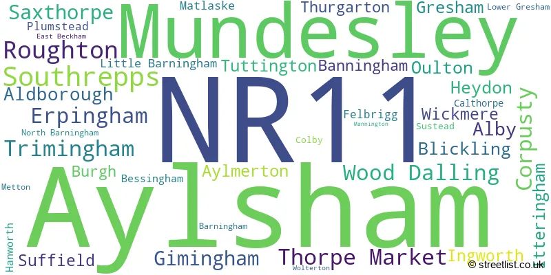
- Alby Hill
- Aldborough
- Antingham
- Aylmerton
- Aylsham
- Banningham
- Bessingham
- Blickling
- Burgh next Aylsham
- Calthorpe
- Colby
- Corpusty
- Corpusty
- Cromer
- East Beckham
- Edgefield Street
- Erpingham
- Felbrigg
- Felmingham
- Gimingham
- Gresham
- Guestwick
- Hanworth
- Heydon
- Ingworth
- Itteringham
- Little Barningham
- Lower Gresham
- Matlaske
- Metton
- Mundesley
- North Walsham
- Norton Corner
- Oulton
- Oulton Street
- Plumstead
- Roughton
- Saxthorpe
- Skeyton
- Southrepps
- Suffield
- Sustead
- Thorpe Market
- Thurgarton
- Trimingham
- Tuttington
- West Beckham
- Wickmere
- Wolterton
- Wood Dalling
| Type of Property | 2018 Average | 2018 Sales | 2017 Average | 2017 Sales | 2016 Average | 2016 Sales | 2015 Average | 2015 Sales |
|---|---|---|---|---|---|---|---|---|
| Detached | £356,298 | 197 | £324,345 | 226 | £310,452 | 218 | £291,963 | 174 |
| Semi-Detached | £255,385 | 87 | £225,941 | 140 | £215,766 | 116 | £194,798 | 98 |
| Terraced | £229,376 | 76 | £213,701 | 71 | £204,253 | 96 | £194,600 | 64 |
| Flats | £139,642 | 12 | £127,458 | 13 | £145,830 | 23 | £134,351 | 24 |