The CW2 postcode district is a postal district located in the CW Crewe postcode area with a population of 44,045 residents according to the 2021 England and Wales Census.
The area of the CW2 postcode district is 16.82 square miles which is 43.56 square kilometres or 10,763.18 acres.
Currently, the CW2 district has about 1006 postcode units spread across 4 geographic postcode sectors.
Given that each sector allows for 400 unique postcode combinations, the district has a capacity of 1,600 postcodes. With 1006 postcodes already in use, this leaves 594 units available.
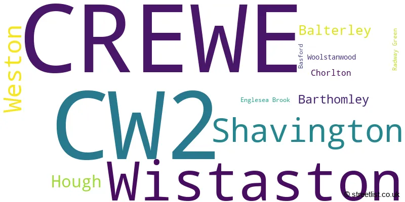
The largest settlement in the CW2 postal code is CREWE followed by Wistaston, and Shavington.
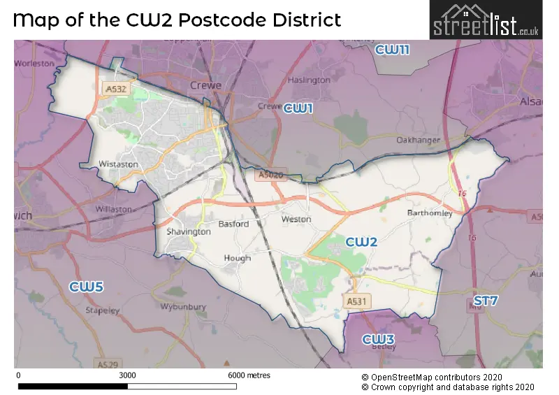
The CW2 Postcode shares a border with CW1 (CREWE, Haslington, Leighton), CW3 (Madeley, Audlem, Woore), CW5 (NANTWICH, Willaston, Stapeley) and ST7 (Alsager, Kidsgrove, Talke).
The primary settlement in the CW2 postcode district is Crewe, which is located in the county of Cheshire. Other significant settlements in this district include Balterley, Barthomley, Basford, Chorlton, Englesea Brook, Hough, Radway Green, Shavington, Weston, and Wistaston. The most significant Postal Town in this district is Crewe.
For the district CW2, we have data on 4 postcode sectors. Here's a breakdown: The sector CW2 5, covers Shavington and Weston in Cheshire. The sector CW2 6, covers Crewe and Wistaston in Cheshire. The sector CW2 7, covers Crewe in Cheshire. The sector CW2 8, covers Wistaston and Crewe in Cheshire.

Map of the CW2 Postcode District
Explore the CW2 postcode district by using our free interactive map.
When it comes to local government, postal geography often disregards political borders. However, for a breakdown in the CW2 District: the district mostly encompasses the Cheshire East (B) (1021 postcodes), and finally, the Newcastle-under-Lyme District (B) area (11 postcodes).
Where is the CW2 Postcode District?
The postcode district CW2 is located in the town of Crewe. Crewe is situated in the West Midlands region of England. It is in close proximity to several nearby towns. To the West, there is Nantwich which is approximately 4.29 miles away. To the North, there is Sandbach which is around 5.41 miles away. To the South East, there is Newcastle which is approximately 8 miles away. To the North West, there is Winsford which is around 9.97 miles away. To the East, there is Stoke-on-Trent which is approximately 10.55 miles away. And to the North East, there is Congleton which is around 11.20 miles away. Additionally, the distance between Crewe and the centre of London is approximately 145.05 miles.
The district is within the post town of CREWE.
The sector has postcodes within the nation of England.
The CW2 Postcode District is covers the following regions.
- Cheshire East - Cheshire - North West (England)
- Staffordshire CC - Shropshire and Staffordshire - West Midlands (England)
Weather Forecast for CW2
Press Button to Show Forecast for Crewe
| Time Period | Icon | Description | Temperature | Rain Probability | Wind |
|---|---|---|---|---|---|
| 00:00 to 03:00 | Cloudy | 15.0°C (feels like 15.0°C) | 5.00% | S 4 mph | |
| 03:00 to 06:00 | Cloudy | 14.0°C (feels like 14.0°C) | 4.00% | S 4 mph | |
| 06:00 to 09:00 | Cloudy | 14.0°C (feels like 13.0°C) | 8.00% | S 7 mph | |
| 09:00 to 12:00 | Cloudy | 16.0°C (feels like 14.0°C) | 5.00% | S 11 mph | |
| 12:00 to 15:00 | Cloudy | 18.0°C (feels like 15.0°C) | 4.00% | SSE 13 mph | |
| 15:00 to 18:00 | Cloudy | 20.0°C (feels like 17.0°C) | 6.00% | SSE 16 mph | |
| 18:00 to 21:00 | Cloudy | 18.0°C (feels like 15.0°C) | 9.00% | SSE 13 mph | |
| 21:00 to 00:00 | Light rain | 16.0°C (feels like 14.0°C) | 41.00% | SE 11 mph |
Press Button to Show Forecast for Crewe
| Time Period | Icon | Description | Temperature | Rain Probability | Wind |
|---|---|---|---|---|---|
| 00:00 to 03:00 | Light rain | 15.0°C (feels like 13.0°C) | 45.00% | SE 11 mph | |
| 03:00 to 06:00 | Light rain | 14.0°C (feels like 12.0°C) | 57.00% | SE 11 mph | |
| 06:00 to 09:00 | Light rain | 14.0°C (feels like 12.0°C) | 55.00% | ESE 9 mph | |
| 09:00 to 12:00 | Heavy rain | 15.0°C (feels like 13.0°C) | 80.00% | ESE 11 mph | |
| 12:00 to 15:00 | Heavy rain | 16.0°C (feels like 14.0°C) | 83.00% | SE 11 mph | |
| 15:00 to 18:00 | Light rain shower (day) | 16.0°C (feels like 14.0°C) | 49.00% | SSE 11 mph | |
| 18:00 to 21:00 | Cloudy | 16.0°C (feels like 14.0°C) | 22.00% | SSE 9 mph | |
| 21:00 to 00:00 | Cloudy | 14.0°C (feels like 12.0°C) | 13.00% | SE 9 mph |
Press Button to Show Forecast for Crewe
| Time Period | Icon | Description | Temperature | Rain Probability | Wind |
|---|---|---|---|---|---|
| 00:00 to 03:00 | Cloudy | 12.0°C (feels like 11.0°C) | 8.00% | SE 9 mph | |
| 03:00 to 06:00 | Clear night | 11.0°C (feels like 10.0°C) | 2.00% | ESE 9 mph | |
| 06:00 to 09:00 | Partly cloudy (day) | 12.0°C (feels like 11.0°C) | 2.00% | ESE 9 mph | |
| 09:00 to 12:00 | Partly cloudy (day) | 15.0°C (feels like 14.0°C) | 6.00% | SE 11 mph | |
| 12:00 to 15:00 | Light rain shower (day) | 18.0°C (feels like 16.0°C) | 36.00% | SE 11 mph | |
| 15:00 to 18:00 | Partly cloudy (day) | 18.0°C (feels like 17.0°C) | 14.00% | SE 9 mph | |
| 18:00 to 21:00 | Partly cloudy (day) | 17.0°C (feels like 16.0°C) | 9.00% | SE 7 mph | |
| 21:00 to 00:00 | Clear night | 13.0°C (feels like 12.0°C) | 2.00% | SE 7 mph |
Press Button to Show Forecast for Crewe
| Time Period | Icon | Description | Temperature | Rain Probability | Wind |
|---|---|---|---|---|---|
| 00:00 to 03:00 | Clear night | 12.0°C (feels like 11.0°C) | 1.00% | SE 7 mph | |
| 03:00 to 06:00 | Clear night | 10.0°C (feels like 9.0°C) | 1.00% | SSE 4 mph | |
| 06:00 to 09:00 | Sunny day | 12.0°C (feels like 11.0°C) | 4.00% | SE 4 mph | |
| 09:00 to 12:00 | Partly cloudy (day) | 16.0°C (feels like 16.0°C) | 4.00% | SSW 4 mph | |
| 12:00 to 15:00 | Cloudy | 18.0°C (feels like 18.0°C) | 13.00% | S 4 mph | |
| 15:00 to 18:00 | Cloudy | 19.0°C (feels like 17.0°C) | 13.00% | E 7 mph | |
| 18:00 to 21:00 | Light rain shower (day) | 17.0°C (feels like 16.0°C) | 31.00% | NNW 7 mph | |
| 21:00 to 00:00 | Partly cloudy (night) | 14.0°C (feels like 13.0°C) | 6.00% | NNW 7 mph |
| Postcode Sector | Delivery Office |
|---|---|
| CW2 5 | Crewe Delivery Office |
| CW2 6 | Crewe Delivery Office |
| CW2 7 | Crewe Delivery Office |
| CW2 8 | Crewe Delivery Office |
| C | W | 2 | - | X | X | X |
| C | W | 2 | Space | Numeric | Letter | Letter |
Tourist Attractions within the CW2 Postcode Area
We found 1 visitor attractions within the CW2 postcode area
| All Saints Church |
|---|
| Places of Worship |
| Place of Worship (still in use) |
| View All Saints Church on Google Maps |
Current Monthly Rental Prices
| # Bedrooms | Min Price | Max Price | Avg Price |
|---|---|---|---|
| 1 | £379 | £675 | £523 |
| 2 | £575 | £1,100 | £791 |
| 3 | £700 | £1,300 | £926 |
| 4 | £575 | £2,250 | £1,413 |
| 5 | £2,350 | £2,350 | £2,350 |
| 8 | £4,550 | £4,550 | £4,550 |
Current House Prices
| # Bedrooms | Min Price | Max Price | Avg Price |
|---|---|---|---|
| £8,000 | £319,000 | £189,250 | |
| 1 | £75,000 | £210,000 | £106,000 |
| 2 | £69,950 | £475,000 | £176,440 |
| 3 | £60,250 | £525,000 | £209,894 |
| 4 | £110,000 | £1,250,000 | £392,105 |
| 5 | £335,000 | £900,000 | £582,375 |
| 6 | £740,000 | £850,000 | £805,000 |
Estate Agents who Operate in the CW2 District
| Logo | Name | Brand Name | Address | Contact Number | Total Properties |
|---|---|---|---|---|---|
 | Crewe | Stephenson Browne Ltd | 234 Nantwich Road Crewe CW2 6BP | 01270 433841 | 45 |
 | Crewe | Butters John Bee | 181 ? 183 Nantwich Road, Crewe, Cheshire, CW2 6DF England | 01270 433339 | 30 |
 | Crewe | Whitegates | 173 Nantwich Road, Crewe, CW2 6DF | 01270 433736 | 30 |
 | Crewe | Bridgfords | 236 Nantwich Road, Crewe, Cheshire, CW2 6BP | 01270 433108 | 23 |
 | Nantwich | Cheshire Lamont | 5 Hospital St, Nantwich CW5 5RH | 01270 433253 | 14 |
Yearly House Price Averages for the CW2 Postcode District
| Type of Property | 2018 Average | 2018 Sales | 2017 Average | 2017 Sales | 2016 Average | 2016 Sales | 2015 Average | 2015 Sales |
|---|---|---|---|---|---|---|---|---|
| Detached | £264,247 | 291 | £272,548 | 296 | £269,153 | 279 | £251,006 | 264 |
| Semi-Detached | £161,394 | 286 | £153,674 | 317 | £147,604 | 301 | £141,220 | 282 |
| Terraced | £112,335 | 211 | £106,310 | 203 | £101,036 | 230 | £98,194 | 198 |
| Flats | £106,088 | 18 | £107,740 | 28 | £89,278 | 35 | £106,809 | 23 |