The CW5 postcode district is a postal district located in the CW Crewe postcode area with a population of 33,192 residents according to the 2021 England and Wales Census.
The area of the CW5 postcode district is 69.17 square miles which is 179.14 square kilometres or 44,265.56 acres.
Currently, the CW5 district has about 970 postcode units spread across 4 geographic postcode sectors.
Given that each sector allows for 400 unique postcode combinations, the district has a capacity of 1,600 postcodes. With 970 postcodes already in use, this leaves 630 units available.
The largest settlement in the CW5 postal code is NANTWICH followed by Willaston, and Stapeley.
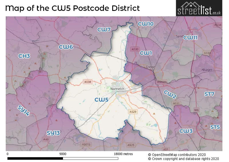
The CW5 Postcode shares a border with CW10 (MIDDLEWICH, Byley, Bostock), CW2 (CREWE, Wistaston, Shavington), CW3 (Madeley, Audlem, Woore), CW6 (TARPORLEY, Kelsall, Bunbury), CW7 (WINSFORD, Winsford Industrial Estate, Wettenhall), SY13 (WHITCHURCH, Prees, Whixall) and SY14 (MALPAS, Tilston, Threapwood).
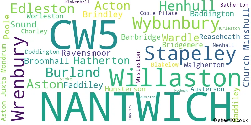
In the CW5 postcode district, the primary settlement is Nantwich, located in the county of Cheshire in England. Other significant settlements within this district include Edleston, Alvaston, Aston Juxta Mondrum, Barbridge, Church Minshull, Henhull, Hurleston, Poole, Reaseheath, Stoke, Wardle, Willaston, Wistaston, Worleston, Batherton, Blakelow, Blakenhall, Bridgemere, Checkley, Doddington, Hatherton, Howbeck, Hunsterson, Stapeley, Walgherton, Wybunbury, Acton, Aston, Austerson, Baddiley, Baddington, Brindley, Broomhall, Burland, Chorley, Coole Pilate, Faddiley, Newhall, Ravensmoor, Sound, and Wrenbury. The post town associated with this postcode district is Nantwich, with the highest number of postcodes.
For the district CW5, we have data on 5 postcode sectors. Here's a breakdown: The sector CW5 5, covers Nantwich in Cheshire. The sector CW5 6, covers Nantwich and Willaston in Cheshire. The sector CW5 7, covers Nantwich and Stapeley and Wybunbury and Willaston in Cheshire. The sector CW5 8, covers Wrenbury and Burland and Aston and Acton in Cheshire. The sector CW5 9 is non-geographic. It's often designated for PO Boxes, large organisations, or special services.

Map of the CW5 Postcode District
Explore the CW5 postcode district by using our free interactive map.
When it comes to local government, postal geography often disregards political borders. However, for a breakdown in the CW5 District: the district mostly encompasses the Cheshire East (B) area with a total of 996 postcodes.
Weather Forecast for CW5
Press Button to Show Forecast for Nantwich
| Time Period | Icon | Description | Temperature | Rain Probability | Wind |
|---|---|---|---|---|---|
| 12:00 to 15:00 | Light rain | 9.0°C (feels like 7.0°C) | 50.00% | NE 9 mph | |
| 15:00 to 18:00 | Overcast | 9.0°C (feels like 7.0°C) | 19.00% | NE 9 mph | |
| 18:00 to 21:00 | Overcast | 9.0°C (feels like 7.0°C) | 14.00% | NE 7 mph | |
| 21:00 to 00:00 | Overcast | 7.0°C (feels like 5.0°C) | 9.00% | NE 7 mph |
Press Button to Show Forecast for Nantwich
| Time Period | Icon | Description | Temperature | Rain Probability | Wind |
|---|---|---|---|---|---|
| 00:00 to 03:00 | Cloudy | 5.0°C (feels like 3.0°C) | 5.00% | NNE 7 mph | |
| 03:00 to 06:00 | Cloudy | 5.0°C (feels like 2.0°C) | 7.00% | N 9 mph | |
| 06:00 to 09:00 | Cloudy | 5.0°C (feels like 2.0°C) | 16.00% | NNW 9 mph | |
| 09:00 to 12:00 | Light rain | 7.0°C (feels like 4.0°C) | 46.00% | NNW 9 mph | |
| 12:00 to 15:00 | Cloudy | 9.0°C (feels like 7.0°C) | 15.00% | NW 11 mph | |
| 15:00 to 18:00 | Partly cloudy (day) | 11.0°C (feels like 8.0°C) | 11.00% | WNW 11 mph | |
| 18:00 to 21:00 | Sunny day | 10.0°C (feels like 8.0°C) | 4.00% | WNW 7 mph | |
| 21:00 to 00:00 | Clear night | 6.0°C (feels like 5.0°C) | 2.00% | SW 7 mph |
Press Button to Show Forecast for Nantwich
| Time Period | Icon | Description | Temperature | Rain Probability | Wind |
|---|---|---|---|---|---|
| 00:00 to 03:00 | Clear night | 5.0°C (feels like 2.0°C) | 1.00% | SSW 7 mph | |
| 03:00 to 06:00 | Clear night | 5.0°C (feels like 2.0°C) | 2.00% | S 9 mph | |
| 06:00 to 09:00 | Sunny day | 6.0°C (feels like 3.0°C) | 3.00% | SSE 9 mph | |
| 09:00 to 12:00 | Partly cloudy (day) | 11.0°C (feels like 8.0°C) | 2.00% | S 13 mph | |
| 12:00 to 15:00 | Overcast | 13.0°C (feels like 10.0°C) | 10.00% | S 16 mph | |
| 15:00 to 18:00 | Cloudy | 14.0°C (feels like 11.0°C) | 7.00% | S 16 mph | |
| 18:00 to 21:00 | Cloudy | 13.0°C (feels like 10.0°C) | 7.00% | S 11 mph | |
| 21:00 to 00:00 | Clear night | 10.0°C (feels like 8.0°C) | 3.00% | SSE 11 mph |
Press Button to Show Forecast for Nantwich
| Time Period | Icon | Description | Temperature | Rain Probability | Wind |
|---|---|---|---|---|---|
| 00:00 to 03:00 | Clear night | 9.0°C (feels like 6.0°C) | 3.00% | SE 11 mph | |
| 03:00 to 06:00 | Partly cloudy (night) | 8.0°C (feels like 5.0°C) | 3.00% | SE 11 mph | |
| 06:00 to 09:00 | Sunny day | 9.0°C (feels like 6.0°C) | 3.00% | SE 11 mph | |
| 09:00 to 12:00 | Sunny day | 13.0°C (feels like 10.0°C) | 4.00% | SE 13 mph | |
| 12:00 to 15:00 | Cloudy | 15.0°C (feels like 12.0°C) | 13.00% | SE 13 mph | |
| 15:00 to 18:00 | Partly cloudy (day) | 16.0°C (feels like 13.0°C) | 11.00% | SE 13 mph | |
| 18:00 to 21:00 | Partly cloudy (day) | 15.0°C (feels like 13.0°C) | 7.00% | ESE 9 mph | |
| 21:00 to 00:00 | Cloudy | 12.0°C (feels like 10.0°C) | 6.00% | ESE 9 mph |
Where is the CW5 Postcode District?
The postcode district for CW5 is located in Nantwich, a town in Cheshire. Nantwich is situated nearby several towns, including Crewe to the North East (5.07 miles away), Whitchurch to the South West (8.46 miles away), Winsford to the North (9.57 miles away), Malpas to the West (9.91 miles away), Market Drayton to the South (11.21 miles away), and Newcastle to the East (12.45 miles away). Additionally, Nantwich is approximately 147.79 miles away from the center of London.
The district is within the post town of NANTWICH.
The sector has postcodes within the nation of England.
The CW5 Postcode District is in the Cheshire East region of Cheshire within the North West (England).
| Postcode Sector | Delivery Office |
|---|---|
| CW5 5 | Nantwich Delivery Office |
| CW5 6 | Nantwich Delivery Office |
| CW5 7 | Nantwich Delivery Office |
| CW5 8 | Nantwich Delivery Office |
| C | W | 5 | - | X | X | X |
| C | W | 5 | Space | Numeric | Letter | Letter |
Current Monthly Rental Prices
| # Bedrooms | Min Price | Max Price | Avg Price |
|---|---|---|---|
| 1 | £595 | £850 | £685 |
| 2 | £700 | £1,100 | £818 |
| 3 | £850 | £1,500 | £1,188 |
| 4 | £1,200 | £2,600 | £1,825 |
| 5 | £1,400 | £1,900 | £1,650 |
Current House Prices
| # Bedrooms | Min Price | Max Price | Avg Price |
|---|---|---|---|
| £125,000 | £5,100,000 | £723,077 | |
| 1 | £80,000 | £260,000 | £128,037 |
| 2 | £65,000 | £750,000 | £213,985 |
| 3 | £85,000 | £850,000 | £346,552 |
| 4 | £144,000 | £1,500,000 | £483,672 |
| 5 | £425,000 | £2,250,000 | £778,130 |
| 6 | £350,000 | £2,950,000 | £1,148,000 |
| 7 | £850,000 | £3,950,000 | £2,033,333 |
| 8 | £1,195,000 | £1,195,000 | £1,195,000 |
Estate Agents who Operate in the CW5 District
| Logo | Name | Brand Name | Address | Contact Number | Total Properties |
|---|---|---|---|---|---|
 | Nantwich | Whitegates | 30 Hospital Street, Nantwich, CW5 5RP | 01270 230044 | 52 |
 | Nantwich | Baker Wynne & Wilson | 38 Pepper Street, Nantwich, Cheshire, CW5 5AB | 01270 433241 | 45 |
 | Nantwich | Cheshire Lamont | 5 Hospital St, Nantwich CW5 5RH | 01270 433253 | 45 |
 | Nantwich | Wright Marshall Estate Agents | 56 High Street, Nantwich, CW5 5BB | 01270 447607 | 39 |
 | Nantwich | Butters John Bee | 20 Beam Street Nantwich CW5 5LL | 01270 433323 | 39 |
- Acton
- Aston juxta Mondrum
- Aston
- Audlem
- Barbridge
- Barnett Brook
- Birchall Moss
- Blakelow
- Blakenhall
- Bridgemere
- Brindley
- Broomhall Green
- Burford
- Burland
- Butt Green
- Checkley
- Cholmondeston
- Chorley
- Church Minshull
- Crewe
- Faddiley
- Hack Green
- Hankelow
- Hatherton
- Holtridge
- Hough
- Howbeck Bank
- Hunsterson Four Lane End
- Larden Green
- Lea Green
- Marley Green
- Nantwich
- Newhall
- Radmore Green
- Ravensmoor
- Rease Heath
- Shavington
- Sound
- Stapeley
- Stoneley Green
- Swanley
- Walgherton
- Wardle
- Willaston
- Worleston
- Wrenbury-cum-Frith
- Wrenbury Heath
- Wybunbury
| Type of Property | 2018 Average | 2018 Sales | 2017 Average | 2017 Sales | 2016 Average | 2016 Sales | 2015 Average | 2015 Sales |
|---|---|---|---|---|---|---|---|---|
| Detached | £375,377 | 289 | £362,536 | 262 | £347,213 | 258 | £329,138 | 235 |
| Semi-Detached | £226,156 | 188 | £211,261 | 196 | £204,202 | 183 | £210,266 | 154 |
| Terraced | £194,078 | 160 | £192,001 | 177 | £191,823 | 196 | £178,102 | 175 |
| Flats | £139,788 | 74 | £128,649 | 64 | £130,221 | 86 | £131,966 | 91 |