The CW3 postcode district is a postal district located in the CW Crewe postcode area with a population of 9,624 residents according to the 2021 England and Wales Census.
The area of the CW3 postcode district is 29.90 square miles which is 77.45 square kilometres or 19,137.96 acres.
Currently, the CW3 district has about 343 postcode units spread across 2 geographic postcode sectors.
Given that each sector allows for 400 unique postcode combinations, the district has a capacity of 800 postcodes. With 343 postcodes already in use, this leaves 457 units available.
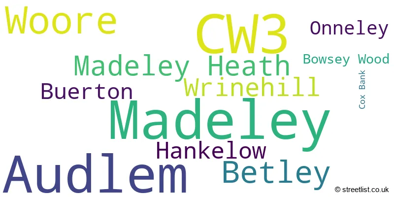
The largest settlement in the CW3 postal code is Madeley followed by Audlem, and Woore.
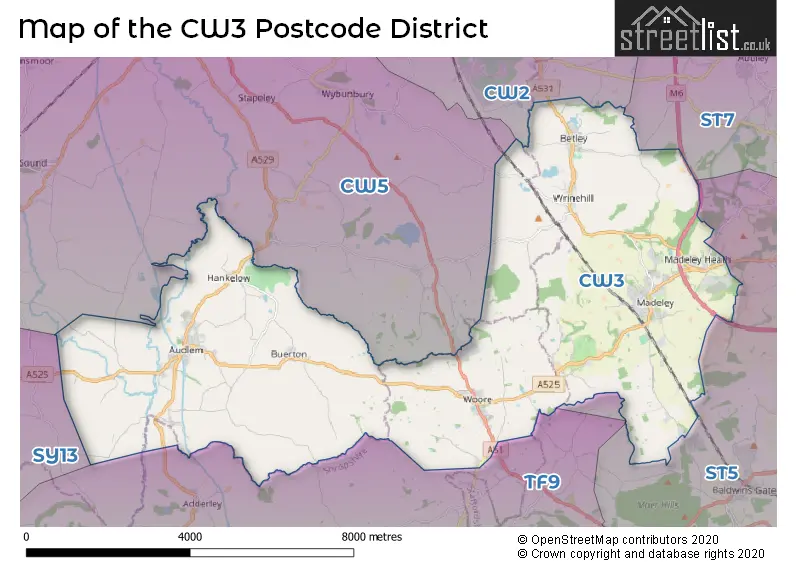
The CW3 Postcode shares a border with CW2 (CREWE, Wistaston, Shavington), CW5 (NANTWICH, Willaston, Stapeley), ST3 (STOKE-ON-TRENT, Weston Coyney), ST5 (NEWCASTLE, Silverdale, Chesterton), ST7 (Alsager, Kidsgrove, Talke) and TF9 (MARKET DRAYTON, Loggerheads, Hinstock).
The primary settlement in the CW3 postcode district is Audlem, located in the county of Cheshire, England. Other significant settlements include Buerton, Cox Bank, and Hankelow, which are also in Cheshire. There are additional settlements in the district, such as Betley, Bowsey Wood, Madeley, Madeley Heath, Onneley, Woore, and Wrinehill, located in Staffordshire and Shropshire. The main post town for the CW3 postcode district is Crewe, which is in Cheshire.
For the district CW3, we have data on 2 postcode sectors. Here's a breakdown: The sector CW3 0, covers Audlem and Hankelow and Buerton in Cheshire. The sector CW3 9, covers Madeley and Betley in Staffordshire. The sector CW3 9, covers Woore in Shropshire.

Map of the CW3 Postcode District
Explore the CW3 postcode district by using our free interactive map.
When it comes to local government, postal geography often disregards political borders. However, for a breakdown in the CW3 District: the district mostly encompasses the Newcastle-under-Lyme District (B) (177 postcodes), followed by the Cheshire East (B) area (124 postcodes), and finally, the Shropshire area (44 postcodes).
Where is the CW3 Postcode District?
The postcode district CW3 is located in the town of Crewe. It is situated near several other towns: Nantwich to the North West (6.64 miles away), Market Drayton to the South (7.06 miles away), Newcastle to the East (7.52 miles away), Sandbach to the North (10.58 miles away), Whitchurch to the West (11.02 miles away), and Stone to the South East (13.18 miles away). Additionally, CW3 is approximately 141.44 miles away from the center of London.
The district is within the post town of CREWE.
The sector has postcodes within the nation of England.
The CW3 Postcode District is covers the following regions.
- Cheshire East - Cheshire - North West (England)
- Staffordshire CC - Shropshire and Staffordshire - West Midlands (England)
- Shropshire CC - Shropshire and Staffordshire - West Midlands (England)
Weather Forecast for CW3
Press Button to Show Forecast for Silverdale
| Time Period | Icon | Description | Temperature | Rain Probability | Wind |
|---|---|---|---|---|---|
| 00:00 to 03:00 | Partly cloudy (night) | 14.0°C (feels like 14.0°C) | 6.00% | SSE 4 mph | |
| 03:00 to 06:00 | Partly cloudy (night) | 13.0°C (feels like 12.0°C) | 3.00% | SSE 4 mph | |
| 06:00 to 09:00 | Cloudy | 13.0°C (feels like 12.0°C) | 6.00% | SSE 7 mph | |
| 09:00 to 12:00 | Cloudy | 15.0°C (feels like 13.0°C) | 4.00% | SSE 11 mph | |
| 12:00 to 15:00 | Cloudy | 18.0°C (feels like 15.0°C) | 5.00% | SSE 13 mph | |
| 15:00 to 18:00 | Cloudy | 19.0°C (feels like 16.0°C) | 12.00% | SSE 13 mph | |
| 18:00 to 21:00 | Cloudy | 17.0°C (feels like 15.0°C) | 17.00% | SSE 13 mph | |
| 21:00 to 00:00 | Light rain | 15.0°C (feels like 13.0°C) | 48.00% | SE 11 mph |
Press Button to Show Forecast for Silverdale
| Time Period | Icon | Description | Temperature | Rain Probability | Wind |
|---|---|---|---|---|---|
| 00:00 to 03:00 | Light rain | 14.0°C (feels like 12.0°C) | 54.00% | SE 11 mph | |
| 03:00 to 06:00 | Light rain | 13.0°C (feels like 11.0°C) | 58.00% | ESE 11 mph | |
| 06:00 to 09:00 | Light rain | 13.0°C (feels like 11.0°C) | 59.00% | ESE 11 mph | |
| 09:00 to 12:00 | Heavy rain | 14.0°C (feels like 12.0°C) | 84.00% | ESE 11 mph | |
| 12:00 to 15:00 | Heavy rain | 15.0°C (feels like 13.0°C) | 82.00% | SE 11 mph | |
| 15:00 to 18:00 | Light rain shower (day) | 16.0°C (feels like 14.0°C) | 48.00% | SSE 11 mph | |
| 18:00 to 21:00 | Light rain shower (day) | 15.0°C (feels like 14.0°C) | 45.00% | SE 9 mph | |
| 21:00 to 00:00 | Cloudy | 13.0°C (feels like 12.0°C) | 16.00% | SE 9 mph |
Press Button to Show Forecast for Silverdale
| Time Period | Icon | Description | Temperature | Rain Probability | Wind |
|---|---|---|---|---|---|
| 00:00 to 03:00 | Partly cloudy (night) | 12.0°C (feels like 10.0°C) | 6.00% | ESE 9 mph | |
| 03:00 to 06:00 | Partly cloudy (night) | 11.0°C (feels like 9.0°C) | 2.00% | ESE 9 mph | |
| 06:00 to 09:00 | Cloudy | 12.0°C (feels like 10.0°C) | 8.00% | ESE 9 mph | |
| 09:00 to 12:00 | Cloudy | 15.0°C (feels like 13.0°C) | 13.00% | SE 9 mph | |
| 12:00 to 15:00 | Light rain shower (day) | 17.0°C (feels like 15.0°C) | 40.00% | SE 9 mph | |
| 15:00 to 18:00 | Partly cloudy (day) | 18.0°C (feels like 16.0°C) | 17.00% | SE 9 mph | |
| 18:00 to 21:00 | Partly cloudy (day) | 17.0°C (feels like 16.0°C) | 12.00% | SE 7 mph | |
| 21:00 to 00:00 | Clear night | 13.0°C (feels like 12.0°C) | 4.00% | SE 7 mph |
Press Button to Show Forecast for Silverdale
| Time Period | Icon | Description | Temperature | Rain Probability | Wind |
|---|---|---|---|---|---|
| 00:00 to 03:00 | Clear night | 11.0°C (feels like 11.0°C) | 4.00% | SSE 4 mph | |
| 03:00 to 06:00 | Clear night | 10.0°C (feels like 9.0°C) | 4.00% | SE 4 mph | |
| 06:00 to 09:00 | Sunny day | 12.0°C (feels like 12.0°C) | 4.00% | SE 4 mph | |
| 09:00 to 12:00 | Partly cloudy (day) | 16.0°C (feels like 15.0°C) | 5.00% | S 4 mph | |
| 12:00 to 15:00 | Cloudy | 18.0°C (feels like 17.0°C) | 12.00% | SSW 4 mph | |
| 15:00 to 18:00 | Light rain shower (day) | 19.0°C (feels like 18.0°C) | 32.00% | W 7 mph | |
| 18:00 to 21:00 | Light rain shower (day) | 18.0°C (feels like 17.0°C) | 31.00% | W 7 mph | |
| 21:00 to 00:00 | Clear night | 14.0°C (feels like 13.0°C) | 7.00% | WNW 7 mph |
| Postcode Sector | Delivery Office |
|---|---|
| CW3 0 | Audlem Scale Payment Delivery Office |
| CW3 0 | Crewe Delivery Office |
| CW3 9 | Little Madeley Scale Payment Delivery Office |
| CW3 9 | Wrinehill Scale Payment Delivery Office |
| CW3 9 | Crewe Delivery Office |
| C | W | 3 | - | X | X | X |
| C | W | 3 | Space | Numeric | Letter | Letter |
Current Monthly Rental Prices
| # Bedrooms | Min Price | Max Price | Avg Price |
|---|---|---|---|
| 1 | £650 | £1,485 | £1,207 |
| 2 | £800 | £1,900 | £1,340 |
| 3 | £1,400 | £1,400 | £1,400 |
| 4 | £1,000 | £1,000 | £1,000 |
Current House Prices
| # Bedrooms | Min Price | Max Price | Avg Price |
|---|---|---|---|
| £350,000 | £995,000 | £672,500 | |
| 2 | £169,500 | £385,000 | £299,917 |
| 3 | £160,000 | £710,000 | £371,106 |
| 4 | £320,000 | £800,000 | £488,034 |
| 5 | £475,000 | £1,500,000 | £888,889 |
| 6 | £750,000 | £750,000 | £750,000 |
| 7 | £2,950,000 | £2,950,000 | £2,950,000 |
Estate Agents who Operate in the CW3 District
| Logo | Name | Brand Name | Address | Contact Number | Total Properties |
|---|---|---|---|---|---|
 | Nantwich | James Du Pavey | 52 Pillory Street, Nantwich, CW5 5BG | 01270 433693 | 19 |
 | Nantwich | Baker Wynne & Wilson | 38 Pepper Street, Nantwich, Cheshire, CW5 5AB | 01270 433241 | 17 |
 | Nantwich | Wright Marshall Estate Agents | 56 High Street, Nantwich, CW5 5BB | 01270 447607 | 8 |
 | Eccleshall | James Du Pavey | 11B High Street, Eccleshall, ST21 6BW | 01785 335306 | 5 |
 | Newcastle-Under-Lyme | Louis Taylor | 5 King Street Newcastle Under Lyme ST5 1EN | 01782 890637 | 3 |
Yearly House Price Averages for the CW3 Postcode District
| Type of Property | 2018 Average | 2018 Sales | 2017 Average | 2017 Sales | 2016 Average | 2016 Sales | 2015 Average | 2015 Sales |
|---|---|---|---|---|---|---|---|---|
| Detached | £353,353 | 111 | £342,317 | 82 | £340,080 | 83 | £324,392 | 65 |
| Semi-Detached | £210,928 | 29 | £195,398 | 49 | £187,305 | 39 | £159,094 | 33 |
| Terraced | £165,651 | 36 | £193,192 | 23 | £180,614 | 28 | £171,048 | 29 |
| Flats | £118,188 | 8 | £146,494 | 8 | £112,167 | 6 | £85,357 | 7 |