The PH15 postcode district is a postal district located in the PH Perth postcode area with a population of 3,545 residents according to the 2011 Scotland Census.
The area of the PH15 postcode district is 258.93 square miles which is 670.62 square kilometres or 165,713.85 acres.
Currently, the PH15 district has about 176 postcode units spread across 1 geographic postcode sectors.
Given that each sector allows for 400 unique postcode combinations, the district has a capacity of 400 postcodes. With 176 postcodes already in use, this leaves 224 units available.
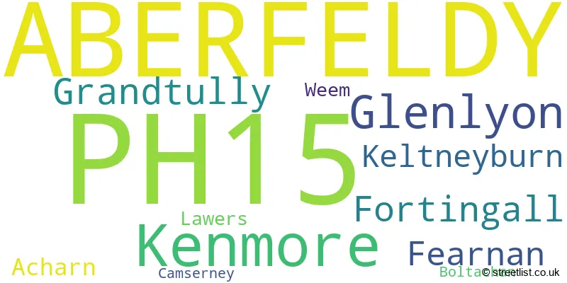
The largest settlement in the PH15 postal code is ABERFELDY followed by Glenlyon, and Kenmore.
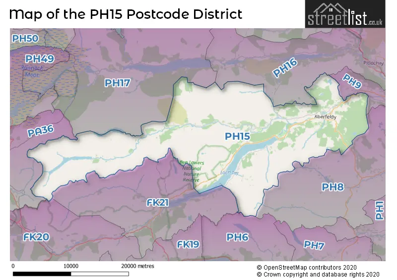
The PH15 Postcode shares a border with PH8 (DUNKELD, Birnam, Amulree), PH9 (Ballinluig, Strathtay, Logierait), FK20 (CRIANLARICH, Tyndrum, Luib), FK21 (KILLIN, Glenlochay, Ardeonaig), PA36 (BRIDGE OF ORCHY), PH6 (Comrie, St. Fillans), PH17 (Rannoch) and PH16 (PITLOCHRY, Kinloch Rannoch, Killiecrankie).
The primary settlement in the PH15 postcode district is Aberfeldy, located in the county of Perth and Kinross in Scotland. Other significant settlements in the district include Acharn, Boltachan, Camserney, Fearnan, Fortingall, Glenlyon, Grandtully, Keltneyburn, Kenmore, Lawers, and Weem. The most significant post town in the district is also Aberfeldy.
For the district PH15, we have data on 1 postcode sectors. Here's a breakdown: The sector PH15 2, covers Aberfeldy in Perth and Kinross.
PH15 Postcode Sectors

Map of the PH15 Postcode District
Explore the PH15 postcode district by using our free interactive map.
When it comes to local government, postal geography often disregards political borders. However, for a breakdown in the PH15 District: the district mostly encompasses the Perth and Kinross area with a total of 178 postcodes.
Where is the PH15 Postcode District?
The data indicates that the postcode district PH15 is located in Aberfeldy, a town in Scotland. Aberfeldy is surrounded by several nearby towns, including Killin to the South West, Pitlochry to the North East, Crieff to the South East, Dunkeld to the East, Corrour to the North West, Callander to the South, and Bridge of Orchy to the West. Additionally, the distance between Aberfeldy and the center of London is 387.1101745930308 miles.
The district is within the post town of ABERFELDY.
The sector has postcodes within the nation of Scotland.
The PH15 Postcode District is in the region of within the .
Weather Forecast for PH15
Press Button to Show Forecast for Meall Greigh
| Time Period | Icon | Description | Temperature | Rain Probability | Wind |
|---|---|---|---|---|---|
| 12:00 to 15:00 | Fog | 7.0°C (feels like 3.0°C) | 19.00% | W 20 mph | |
| 15:00 to 18:00 | Cloudy | 8.0°C (feels like 5.0°C) | 7.00% | W 13 mph | |
| 18:00 to 21:00 | Cloudy | 8.0°C (feels like 6.0°C) | 4.00% | W 9 mph | |
| 21:00 to 00:00 | Cloudy | 8.0°C (feels like 5.0°C) | 6.00% | WSW 11 mph |
Press Button to Show Forecast for Meall Greigh
| Time Period | Icon | Description | Temperature | Rain Probability | Wind |
|---|---|---|---|---|---|
| 00:00 to 03:00 | Cloudy | 8.0°C (feels like 5.0°C) | 6.00% | S 9 mph | |
| 03:00 to 06:00 | Cloudy | 7.0°C (feels like 4.0°C) | 5.00% | SSW 11 mph | |
| 06:00 to 09:00 | Cloudy | 8.0°C (feels like 4.0°C) | 5.00% | SSW 13 mph | |
| 09:00 to 12:00 | Cloudy | 8.0°C (feels like 5.0°C) | 5.00% | SSW 18 mph | |
| 12:00 to 15:00 | Cloudy | 10.0°C (feels like 6.0°C) | 4.00% | SSW 18 mph | |
| 15:00 to 18:00 | Partly cloudy (day) | 11.0°C (feels like 7.0°C) | 1.00% | SSW 20 mph | |
| 18:00 to 21:00 | Sunny day | 10.0°C (feels like 7.0°C) | 0.00% | SSW 22 mph | |
| 21:00 to 00:00 | Clear night | 8.0°C (feels like 4.0°C) | 0.00% | S 22 mph |
Press Button to Show Forecast for Meall Greigh
| Time Period | Icon | Description | Temperature | Rain Probability | Wind |
|---|---|---|---|---|---|
| 00:00 to 03:00 | Clear night | 7.0°C (feels like 3.0°C) | 0.00% | S 20 mph | |
| 03:00 to 06:00 | Clear night | 5.0°C (feels like 2.0°C) | 0.00% | SSE 16 mph | |
| 06:00 to 09:00 | Sunny day | 6.0°C (feels like 3.0°C) | 1.00% | SE 11 mph | |
| 09:00 to 12:00 | Partly cloudy (day) | 10.0°C (feels like 7.0°C) | 0.00% | SSE 11 mph | |
| 12:00 to 15:00 | Partly cloudy (day) | 12.0°C (feels like 9.0°C) | 1.00% | S 16 mph | |
| 15:00 to 18:00 | Partly cloudy (day) | 13.0°C (feels like 10.0°C) | 3.00% | SSW 16 mph | |
| 18:00 to 21:00 | Partly cloudy (day) | 12.0°C (feels like 9.0°C) | 3.00% | S 13 mph | |
| 21:00 to 00:00 | Partly cloudy (night) | 9.0°C (feels like 6.0°C) | 2.00% | SSE 11 mph |
Press Button to Show Forecast for Meall Greigh
| Time Period | Icon | Description | Temperature | Rain Probability | Wind |
|---|---|---|---|---|---|
| 00:00 to 03:00 | Partly cloudy (night) | 7.0°C (feels like 4.0°C) | 2.00% | SE 13 mph | |
| 03:00 to 06:00 | Partly cloudy (night) | 6.0°C (feels like 2.0°C) | 1.00% | SE 13 mph | |
| 06:00 to 09:00 | Cloudy | 7.0°C (feels like 4.0°C) | 5.00% | SE 13 mph | |
| 09:00 to 12:00 | Cloudy | 10.0°C (feels like 7.0°C) | 5.00% | SSE 13 mph | |
| 12:00 to 15:00 | Light rain shower (day) | 11.0°C (feels like 8.0°C) | 33.00% | SSE 16 mph | |
| 15:00 to 18:00 | Light rain shower (day) | 11.0°C (feels like 7.0°C) | 40.00% | SSE 16 mph | |
| 18:00 to 21:00 | Heavy rain shower (day) | 9.0°C (feels like 6.0°C) | 55.00% | SSE 13 mph | |
| 21:00 to 00:00 | Cloudy | 7.0°C (feels like 4.0°C) | 14.00% | SE 13 mph |
Press Button to Show Forecast for Meall Greigh
| Time Period | Icon | Description | Temperature | Rain Probability | Wind |
|---|---|---|---|---|---|
| 00:00 to 03:00 | Light rain | 6.0°C (feels like 3.0°C) | 51.00% | ESE 13 mph | |
| 03:00 to 06:00 | Heavy rain | 6.0°C (feels like 3.0°C) | 72.00% | ESE 11 mph | |
| 06:00 to 09:00 | Drizzle | 6.0°C (feels like 3.0°C) | 37.00% | SSE 13 mph | |
| 09:00 to 12:00 | Light rain | 7.0°C (feels like 4.0°C) | 48.00% | SE 13 mph | |
| 12:00 to 15:00 | Light rain shower (day) | 8.0°C (feels like 6.0°C) | 42.00% | SSE 11 mph | |
| 15:00 to 18:00 | Light rain shower (day) | 9.0°C (feels like 6.0°C) | 47.00% | SSW 11 mph | |
| 18:00 to 21:00 | Heavy rain shower (day) | 7.0°C (feels like 4.0°C) | 59.00% | S 13 mph | |
| 21:00 to 00:00 | Light rain | 6.0°C (feels like 3.0°C) | 44.00% | SE 11 mph |
Postcode Sectors within the PH15 District
| Postcode Sector | Delivery Office |
|---|---|
| PH15 2 | Aberfeldy Scale Payment Delivery Office |
| P | H | 1 | 5 | - | X | X | X |
| P | H | 1 | 5 | Space | Numeric | Letter | Letter |
Current Monthly Rental Prices
| # Bedrooms | Min Price | Max Price | Avg Price |
|---|
Current House Prices
| # Bedrooms | Min Price | Max Price | Avg Price |
|---|---|---|---|
| £25,000 | £100,000,000 | £31,308,119 | |
| 2 | £110,000 | £350,000 | £234,444 |
| 3 | £150,000 | £875,000 | £417,000 |
| 4 | £245,000 | £245,000 | £245,000 |
| 5 | £360,000 | £1,400,000 | £880,000 |
Estate Agents who Operate in the PH15 District
| Logo | Name | Brand Name | Address | Contact Number | Total Properties |
|---|---|---|---|---|---|
 | Perth | Savills Country Houses | Earn House, Broxden Business Park, Lamberkine Drive Perth PH1 1RA | 01738 505943 | 8 |
 | Town & Country | Rettie & Co | 11 Wemyss Place, Edinburgh, EH6 7HT | 0131 381 3509 | 7 |
 | Crieff | Irving Geddes W.S. | 25 West High Street, Crieff, PH7 4AU | 01764 915796 | 6 |
 | Pitlochry | J & H Mitchell | 51 Atholl Road, Pitlochry, PH16 5BU | 01790 727058 | 3 |
 | Glasgow | Prime Property Auctions (Scotland) Ltd | 126 West Regent Street, Glasgow, G2 2RQ | 0141 465 5880 | 1 |