The SK13 1 postcode sector lies where the four counties of Derbyshire, South Yorkshire, Greater Manchester, and West Yorkshire meet.
Did you know? According to the 2021 Census, the SK13 1 postcode sector is home to a bustling 6,627 residents!
Given that each sector allows for 400 unique postcode combinations. Letters C, I, K, M, O and V are not allowed in the last two letters of a postcode. With 179 postcodes already in use, this leaves 221 units available.
The largest settlement in the SK13 1 postal code is Hadfield followed by Tintwistle, and Padfield.
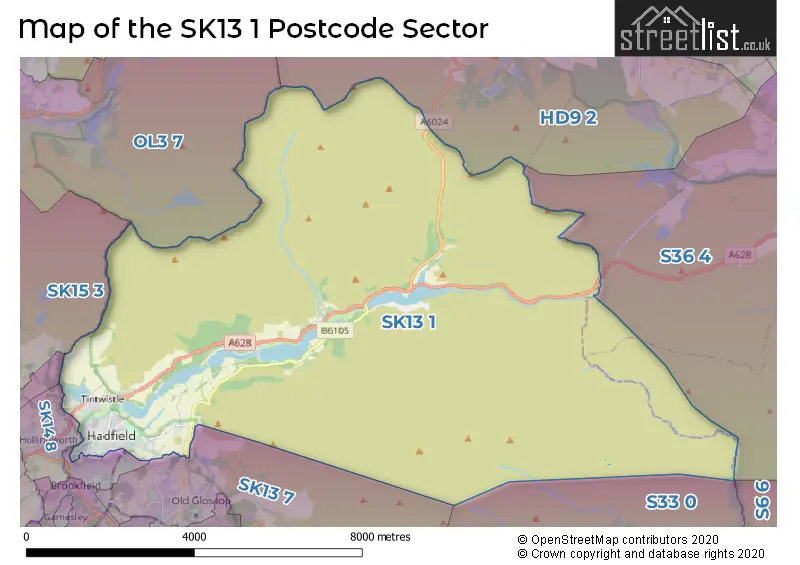
The SK13 1 Postcode shares a border with OL3 7 (Greenfield), S36 4 (Crow Edge, Stocksbridge, Dunford Bridge), SK13 2 (Hadfield), SK13 7 (GLOSSOP), SK14 8 (Hollingworth), S6 6 (Stannington, Loxley, Bradfield), S33 0 (Bamford), SK14 6 (Mottram, Broadbottom), SK15 3 (STALYBRIDGE, Carrbrook, Millbrook) and HD9 2 (HOLMFIRTH, Holmbridge, Hade Edge).
The sector is within the post town of GLOSSOP.
SK13 1 is a postcode sector within the SK1 postcode district which is within the SK Stockport postcode area.
The Royal Mail delivery office for the SK13 1 postal sector is the Stockport Central Delivery Office and Stockport 1 Delivery Office.
The area of the SK13 1 postcode sector is 36.62 square miles which is 94.84 square kilometres or 23,436.34 square acres.
The SK13 1 postcode sector is crossed by the A628 Major A road.
Waterways within the SK13 1 postcode sector include the River Derwent, River Alport, River Etherow, River Westend, Salter's Brook, Withens Brook, Heydon Brook, Yellowslacks Brook, Dovestone Clough, Deep Grain, Grinah Grain, Crowden Great Brook, Lower Small Clough, Barrow Clough.

Map of the SK13 1 Postcode Sector
Explore the SK13 1 postcode sector by using our free interactive map.
| S | K | 1 | 3 | - | 1 | X | X |
| S | K | 1 | 3 | Space | 1 | Letter | Letter |
Official List of Streets
Hadfield (76 Streets)
Tintwistle (29 Streets)
Padfield (14 Streets)
Torside (1 Streets)
Unofficial Streets or Alternative Spellings
Hadfield
CROSS STREET HIGHER BARN ROAD MARLOW STREET MARSDEN STREET QUEEN STREET RAILWAY STREET STANYFORTH STREET WALKER STREET BANK TERRACE CHAPEL WAY CHAPLE WAY CROSSGATE LANE EBENEZER BROW LADY SHAW BRIDGE LANCE CORPORAL STEVEN BAGSHAW AVE LITTLE PADFIELD ROAD LONGDENDALE TRAIL OAKSIDE BRIDGE PEAK VIEW RHODESWOOD AVE SALISBURY COTTAGES SALTERS BROOK BRIDGE SEXTON STREET SPRINGBANK SUMMER HOUSE LANE TINTWISTLE BRIDGE TORSIDE CLOUGH TORSIDE ST TORSIDE VIEW VALEHOUSE WY WATKIN DRIVE WOODHEAD BRIDGEHolmbridge
WOODHEAD ROADHollingworth
MANCHESTER ROAD WATER LANEWeather Forecast for SK13 1
Press Button to Show Forecast for Crowden-In-Longdendale
| Time Period | Icon | Description | Temperature | Rain Probability | Wind |
|---|---|---|---|---|---|
| 12:00 to 15:00 | Cloudy | 13.0°C (feels like 12.0°C) | 8.00% | NE 7 mph | |
| 15:00 to 18:00 | Cloudy | 15.0°C (feels like 14.0°C) | 4.00% | ENE 4 mph | |
| 18:00 to 21:00 | Sunny day | 14.0°C (feels like 13.0°C) | 0.00% | ENE 7 mph | |
| 21:00 to 00:00 | Clear night | 11.0°C (feels like 10.0°C) | 0.00% | ENE 4 mph |
Press Button to Show Forecast for Crowden-In-Longdendale
| Time Period | Icon | Description | Temperature | Rain Probability | Wind |
|---|---|---|---|---|---|
| 00:00 to 03:00 | Clear night | 9.0°C (feels like 8.0°C) | 0.00% | E 2 mph | |
| 03:00 to 06:00 | Partly cloudy (night) | 8.0°C (feels like 8.0°C) | 1.00% | SSE 2 mph | |
| 06:00 to 09:00 | Cloudy | 10.0°C (feels like 10.0°C) | 3.00% | SW 2 mph | |
| 09:00 to 12:00 | Partly cloudy (day) | 14.0°C (feels like 13.0°C) | 1.00% | SSW 7 mph | |
| 12:00 to 15:00 | Cloudy | 16.0°C (feels like 14.0°C) | 4.00% | SW 9 mph | |
| 15:00 to 18:00 | Cloudy | 17.0°C (feels like 16.0°C) | 9.00% | SW 7 mph | |
| 18:00 to 21:00 | Cloudy | 15.0°C (feels like 15.0°C) | 7.00% | W 4 mph | |
| 21:00 to 00:00 | Cloudy | 12.0°C (feels like 12.0°C) | 5.00% | W 2 mph |
Press Button to Show Forecast for Crowden-In-Longdendale
| Time Period | Icon | Description | Temperature | Rain Probability | Wind |
|---|---|---|---|---|---|
| 00:00 to 03:00 | Cloudy | 11.0°C (feels like 11.0°C) | 5.00% | W 2 mph | |
| 03:00 to 06:00 | Cloudy | 10.0°C (feels like 10.0°C) | 5.00% | W 2 mph | |
| 06:00 to 09:00 | Cloudy | 11.0°C (feels like 11.0°C) | 5.00% | W 4 mph | |
| 09:00 to 12:00 | Cloudy | 14.0°C (feels like 14.0°C) | 5.00% | W 4 mph | |
| 12:00 to 15:00 | Cloudy | 16.0°C (feels like 16.0°C) | 4.00% | W 7 mph | |
| 15:00 to 18:00 | Cloudy | 17.0°C (feels like 16.0°C) | 4.00% | WNW 7 mph | |
| 18:00 to 21:00 | Cloudy | 16.0°C (feels like 16.0°C) | 4.00% | WNW 4 mph | |
| 21:00 to 00:00 | Cloudy | 12.0°C (feels like 11.0°C) | 4.00% | NW 2 mph |
Press Button to Show Forecast for Crowden-In-Longdendale
| Time Period | Icon | Description | Temperature | Rain Probability | Wind |
|---|---|---|---|---|---|
| 00:00 to 03:00 | Cloudy | 10.0°C (feels like 10.0°C) | 4.00% | NW 2 mph | |
| 03:00 to 06:00 | Cloudy | 11.0°C (feels like 10.0°C) | 4.00% | SSW 2 mph | |
| 06:00 to 09:00 | Cloudy | 12.0°C (feels like 12.0°C) | 4.00% | S 2 mph | |
| 09:00 to 12:00 | Cloudy | 16.0°C (feels like 16.0°C) | 5.00% | S 2 mph | |
| 12:00 to 15:00 | Cloudy | 18.0°C (feels like 17.0°C) | 6.00% | S 4 mph | |
| 15:00 to 18:00 | Cloudy | 18.0°C (feels like 18.0°C) | 7.00% | S 4 mph | |
| 18:00 to 21:00 | Cloudy | 17.0°C (feels like 17.0°C) | 6.00% | S 4 mph | |
| 21:00 to 00:00 | Cloudy | 13.0°C (feels like 13.0°C) | 5.00% | S 4 mph |
Press Button to Show Forecast for Crowden-In-Longdendale
| Time Period | Icon | Description | Temperature | Rain Probability | Wind |
|---|---|---|---|---|---|
| 00:00 to 03:00 | Clear night | 12.0°C (feels like 11.0°C) | 1.00% | S 4 mph | |
| 03:00 to 06:00 | Clear night | 10.0°C (feels like 10.0°C) | 1.00% | S 4 mph | |
| 06:00 to 09:00 | Sunny day | 12.0°C (feels like 12.0°C) | 1.00% | SSW 2 mph | |
| 09:00 to 12:00 | Sunny day | 17.0°C (feels like 16.0°C) | 1.00% | S 4 mph | |
| 12:00 to 15:00 | Partly cloudy (day) | 19.0°C (feels like 17.0°C) | 2.00% | S 7 mph | |
| 15:00 to 18:00 | Cloudy | 19.0°C (feels like 17.0°C) | 6.00% | S 9 mph | |
| 18:00 to 21:00 | Partly cloudy (day) | 18.0°C (feels like 17.0°C) | 2.00% | S 7 mph | |
| 21:00 to 00:00 | Clear night | 14.0°C (feels like 13.0°C) | 2.00% | S 4 mph |
Schools and Places of Education Within the SK13 1 Postcode Sector
Hadfield Infant School
Community school
Mersey Bank Road, Glossop, Derbyshire, SK13 1PN
Head: Ms Francesca Dodd
Ofsted Rating: Good
Inspection: 2023-11-08 (181 days ago)
Website: Visit Hadfield Infant School Website
Phone: 01457853958
Number of Pupils: 143
Padfield Community Primary School
Community school
Rhodes Street, Glossop, Derbyshire, SK13 1EQ
Head: Ms Anne Moore
Ofsted Rating: Good
Inspection: 2018-09-18 (2058 days ago)
Website: Visit Padfield Community Primary School Website
Phone: 01457852751
Number of Pupils: 115
St Charles' Catholic Voluntary Academy
Academy sponsor led
The Carriage Drive, Glossop, Derbyshire, SK13 1PJ
Head: Mr Ian Bowd
Ofsted Rating: Good
Inspection: 2022-11-03 (551 days ago)
Website: Visit St Charles' Catholic Voluntary Academy Website
Phone: 01457852692
Number of Pupils: 180
Tintwistle CofE (Aided) Primary School
Voluntary aided school
South Close, Glossop, Derbyshire, SK13 1LY
Head: Mr Michael Mulhall
Ofsted Rating: Good
Inspection: 2023-02-02 (460 days ago)
Website: Visit Tintwistle CofE (Aided) Primary School Website
Phone: 01457852611
Number of Pupils: 120
House Prices in the SK13 1 Postcode Sector
| Type of Property | 2018 Average | 2018 Sales | 2017 Average | 2017 Sales | 2016 Average | 2016 Sales | 2015 Average | 2015 Sales |
|---|---|---|---|---|---|---|---|---|
| Detached | £247,542 | 12 | £277,467 | 15 | £298,112 | 17 | £229,064 | 14 |
| Semi-Detached | £173,819 | 24 | £173,206 | 26 | £191,700 | 17 | £157,152 | 23 |
| Terraced | £136,026 | 72 | £132,252 | 65 | £116,019 | 75 | £125,220 | 69 |
| Flats | £88,250 | 4 | £93,500 | 2 | £84,056 | 9 | £0 | 0 |
Important Postcodes SK13 1 in the Postcode Sector
SK13 1EQ is the postcode for Padfield Community Primary School, Rhodes Street, and Padfield Community Primary School, Rhodes Street, Padfield
SK13 1HZ is the postcode for Crowden Outdoor Education Centre, Old Lane, Crowden
SK13 1JT is the postcode for Tintwistle C of E Primary School, South Close
SK13 1PJ is the postcode for St. Charles Catholic Primary School, The Carriage Drive, and St. Charles Catholic Primary School, The Carriage Drive, Hadfield
SK13 1PN is the postcode for Hadfield Infant School, Mersey Bank Road, and HADFIELD INFANT SCHOOL, MERSEY BANK ROAD, HADFIELD
| The SK13 1 Sector is within these Local Authorities |
|
|---|---|
| The SK13 1 Sector is within these Counties |
|
| The SK13 1 Sector is within these Water Company Areas |
|