The BS2 postcode district is a postal district located in the BS Bristol postcode area with a population of 19,401 residents according to the 2021 England and Wales Census.
The area of the BS2 postcode district is 1.39 square miles which is 3.59 square kilometres or 887.11 acres.
Currently, the BS2 district has about 636 postcode units spread across 29 geographic postcode sectors.
Given that each sector allows for 400 unique postcode combinations, the district has a capacity of 11,600 postcodes. With 636 postcodes already in use, this leaves 10964 units available.
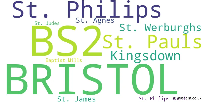
The largest settlement in the BS2 postal code is BRISTOL followed by St. Philips, and St. Pauls.
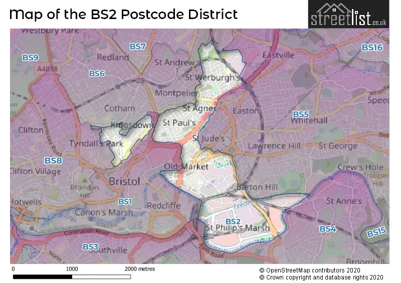
The BS2 Postcode shares a border with BS4 (BRISTOL, Brislington, Arnos Vale), BS5 (BRISTOL, St. George, Eastville), BS6 (BRISTOL, St. Andrews, Redland), BS7 (BRISTOL, Horfield, Bishopston) and BS1 (BRISTOL, Redcliffe).
In the BS2 postcode district, the primary settlement with the highest count is Bristol. Other significant settlements in this district include St. Philips, St. Philips Marsh, Kingsdown, St. James, St. Pauls, Baptist Mills, St. Agnes, St. Judes, and St. Werburghs. The county within which these settlements are located is the county of Bristol, which is in England. The most significant post town in this district is also Bristol.
For the district BS2, we have data on 4 postcode sectors. Here's a breakdown: The sector BS2 0, covers Bristol and St. Philips in Bristol. The sector BS2 2 is non-geographic. It's often designated for PO Boxes, large organisations, or special services. The sector BS2 8, covers Bristol in Bristol. The sector BS2 9, covers Bristol and St. Pauls in Bristol.

Map of the BS2 Postcode District
Explore the BS2 postcode district by using our free interactive map.
When it comes to local government, postal geography often disregards political borders. However, for a breakdown in the BS2 District: the district mostly encompasses the City of Bristol (B) area with a total of 657 postcodes.
Weather Forecast for BS2
Press Button to Show Forecast for Bristol
| Time Period | Icon | Description | Temperature | Rain Probability | Wind |
|---|---|---|---|---|---|
| 03:00 to 06:00 | Light rain | 7.0°C (feels like 4.0°C) | 55.00% | ENE 9 mph | |
| 06:00 to 09:00 | Overcast | 6.0°C (feels like 3.0°C) | 18.00% | NE 9 mph | |
| 09:00 to 12:00 | Cloudy | 7.0°C (feels like 4.0°C) | 13.00% | NE 11 mph | |
| 12:00 to 15:00 | Overcast | 9.0°C (feels like 7.0°C) | 11.00% | NE 11 mph | |
| 15:00 to 18:00 | Cloudy | 11.0°C (feels like 8.0°C) | 8.00% | NE 11 mph | |
| 18:00 to 21:00 | Cloudy | 10.0°C (feels like 7.0°C) | 9.00% | NE 11 mph | |
| 21:00 to 00:00 | Overcast | 8.0°C (feels like 5.0°C) | 13.00% | NNE 11 mph |
Press Button to Show Forecast for Bristol
| Time Period | Icon | Description | Temperature | Rain Probability | Wind |
|---|---|---|---|---|---|
| 00:00 to 03:00 | Light rain | 7.0°C (feels like 4.0°C) | 49.00% | NNE 11 mph | |
| 03:00 to 06:00 | Heavy rain | 7.0°C (feels like 3.0°C) | 78.00% | N 11 mph | |
| 06:00 to 09:00 | Heavy rain | 6.0°C (feels like 3.0°C) | 75.00% | N 11 mph | |
| 09:00 to 12:00 | Light rain | 8.0°C (feels like 5.0°C) | 51.00% | NNW 9 mph | |
| 12:00 to 15:00 | Overcast | 10.0°C (feels like 8.0°C) | 19.00% | WNW 9 mph | |
| 15:00 to 18:00 | Cloudy | 12.0°C (feels like 10.0°C) | 12.00% | W 9 mph | |
| 18:00 to 21:00 | Partly cloudy (day) | 11.0°C (feels like 9.0°C) | 6.00% | WSW 9 mph | |
| 21:00 to 00:00 | Clear night | 8.0°C (feels like 7.0°C) | 1.00% | WSW 7 mph |
Press Button to Show Forecast for Bristol
| Time Period | Icon | Description | Temperature | Rain Probability | Wind |
|---|---|---|---|---|---|
| 00:00 to 03:00 | Clear night | 7.0°C (feels like 5.0°C) | 1.00% | SW 7 mph | |
| 03:00 to 06:00 | Clear night | 6.0°C (feels like 4.0°C) | 2.00% | S 7 mph | |
| 06:00 to 09:00 | Sunny day | 7.0°C (feels like 5.0°C) | 2.00% | S 7 mph | |
| 09:00 to 12:00 | Cloudy | 12.0°C (feels like 9.0°C) | 6.00% | S 11 mph | |
| 12:00 to 15:00 | Cloudy | 13.0°C (feels like 11.0°C) | 7.00% | S 13 mph | |
| 15:00 to 18:00 | Cloudy | 14.0°C (feels like 11.0°C) | 7.00% | S 16 mph | |
| 18:00 to 21:00 | Cloudy | 13.0°C (feels like 10.0°C) | 7.00% | S 11 mph | |
| 21:00 to 00:00 | Partly cloudy (night) | 10.0°C (feels like 8.0°C) | 4.00% | SSE 11 mph |
Press Button to Show Forecast for Bristol
| Time Period | Icon | Description | Temperature | Rain Probability | Wind |
|---|---|---|---|---|---|
| 00:00 to 03:00 | Partly cloudy (night) | 9.0°C (feels like 7.0°C) | 4.00% | SE 9 mph | |
| 03:00 to 06:00 | Clear night | 9.0°C (feels like 7.0°C) | 4.00% | SE 9 mph | |
| 06:00 to 09:00 | Sunny day | 9.0°C (feels like 7.0°C) | 5.00% | SE 9 mph | |
| 09:00 to 12:00 | Partly cloudy (day) | 13.0°C (feels like 11.0°C) | 9.00% | SE 11 mph | |
| 12:00 to 15:00 | Partly cloudy (day) | 15.0°C (feels like 12.0°C) | 9.00% | SE 13 mph | |
| 15:00 to 18:00 | Cloudy | 15.0°C (feels like 13.0°C) | 16.00% | SE 11 mph | |
| 18:00 to 21:00 | Cloudy | 14.0°C (feels like 13.0°C) | 12.00% | SE 9 mph | |
| 21:00 to 00:00 | Clear night | 12.0°C (feels like 11.0°C) | 6.00% | SE 7 mph |
Where is the BS2 Postcode District?
The postcode district of BS2 is located in the town of Bristol. Bristol is the district town associated with the BS2 postcode. Among the nearby towns mentioned, Bath is about 9.82 miles to the southeast, Clevedon is approximately 11.28 miles to the west, Caldicot is around 12.40 miles to the northwest, Badminton is about 12.70 miles to the northeast, Chepstow is approximately 12.97 miles to the north, and Winscombe is around 14.98 miles to the southwest. Furthermore, the distance to the center of London from the BS2 postcode district is about 105.72 miles.
The district is within the post town of BRISTOL.
The sector has postcodes within the nation of England.
The BS2 Postcode District is in the Bristol, City of region of Gloucestershire, Wiltshire and Bath/Bristol area within the South West (England).
Postcode Sectors within the BS2 District
| Postcode Sector | Delivery Office |
|---|---|
| BS2 0 | Bristol East Central Delivery Office |
| BS2 8 | Bristol East Central Delivery Office |
| BS2 9 | Bristol East Central Delivery Office |
| B | S | 2 | - | X | X | X |
| B | S | 2 | Space | Numeric | Letter | Letter |
Current Monthly Rental Prices
| # Bedrooms | Min Price | Max Price | Avg Price |
|---|---|---|---|
| £1,430 | £1,560 | £1,473 | |
| 1 | £1,570 | £2,550 | £2,094 |
| 2 | £1,500 | £3,500 | £2,060 |
| 3 | £3,200 | £3,200 | £3,200 |
| 4 | £2,500 | £2,500 | £2,500 |
Current House Prices
| # Bedrooms | Min Price | Max Price | Avg Price |
|---|---|---|---|
| £500,000 | £1,200,000 | £850,000 | |
| 2 | £400,000 | £435,000 | £421,250 |
| 3 | £395,000 | £620,000 | £523,538 |
| 4 | £675,000 | £1,250,000 | £933,333 |
| 5 | £600,000 | £600,000 | £600,000 |
| 7 | £575,000 | £575,000 | £575,000 |
| 9 | £900,000 | £900,000 | £900,000 |
Estate Agents who Operate in the BS2 District
| Logo | Name | Brand Name | Address | Contact Number | Total Properties |
|---|---|---|---|---|---|
 | Bristol | Boardwalk Property Co | Harbury Road, Westbury-On-Trym, Bristol, BS9 4PN | 0117 463 0220 | 9 |
 | Bishopston | Ocean | 201 Gloucester Road, Bishopston, Bristol, BS7 8BG | 0117 463 0093 | 8 |
 | Clifton | Allen & Harris | 23 Regent Street, Clifton, Bristol, Gloucestershire, BS8 4HW | 0117 463 6785 | 6 |
 | Bristol | Hopewell | Hope Chapel House, Hope Chapel Hill, Clifton, BS8 4ND | 0117 463 0268 | 6 |
 | Clifton | Ocean | 187-189 Whiteladies Road, Clifton, Bristol, BS8 2RY | 0117 463 0091 | 4 |
| Type of Property | 2018 Average | 2018 Sales | 2017 Average | 2017 Sales | 2016 Average | 2016 Sales | 2015 Average | 2015 Sales |
|---|---|---|---|---|---|---|---|---|
| Detached | £287,250 | 2 | £417,500 | 1 | £433,333 | 3 | £327,500 | 2 |
| Semi-Detached | £459,838 | 8 | £382,386 | 7 | £290,000 | 4 | £298,000 | 2 |
| Terraced | £365,369 | 63 | £328,775 | 73 | £335,800 | 89 | £283,445 | 97 |
| Flats | £214,350 | 276 | £231,165 | 317 | £208,077 | 249 | £188,058 | 234 |