The M33 postcode district is a postal district located in the M Manchester postcode area with a population of 61,924 residents according to the 2021 England and Wales Census.
The area of the M33 postcode district is 5.80 square miles which is 15.03 square kilometres or 3,714.59 acres.
Currently, the M33 district has about 1558 postcode units spread across 6 geographic postcode sectors.
Given that each sector allows for 400 unique postcode combinations, the district has a capacity of 2,400 postcodes. With 1558 postcodes already in use, this leaves 842 units available.
The M33 postal code covers the settlement of SALE.
The M33 Postcode shares a border with WA14 (ALTRINCHAM, Bowdon, Broadheath), WA15 (Timperley, Hale, Hale Barns), M23 (MANCHESTER, Roundthorn Industrial Estate, Wythenshawe), M21 (MANCHESTER, Chorlton Cum Hardy), M31 (Partington, Carrington), M32 (Stretford) and M41 (Urmston).
In the M33 postcode district, the primary settlement is Sale, which is located in the county of Greater Manchester. Sale has the highest count of postcodes, with 314. The other significant settlement in the district is Brooklands, with a count of 5. The most significant post town in the district is also Sale, which is in Greater Manchester, England.
For the district M33, we have data on 7 postcode sectors. Here's a breakdown: The sector M33 0 is non-geographic. It's often designated for PO Boxes, large organisations, or special services. The sector M33 2, covers Sale in Greater Manchester. The sector M33 3, covers Sale in Greater Manchester. The sector M33 4, covers Sale in Greater Manchester. The sector M33 5, covers Sale in Greater Manchester. The sector M33 6, covers Sale in Greater Manchester. The sector M33 7, covers Sale in Greater Manchester.

Map of the M33 Postcode District
Explore the M33 postcode district by using our free interactive map.
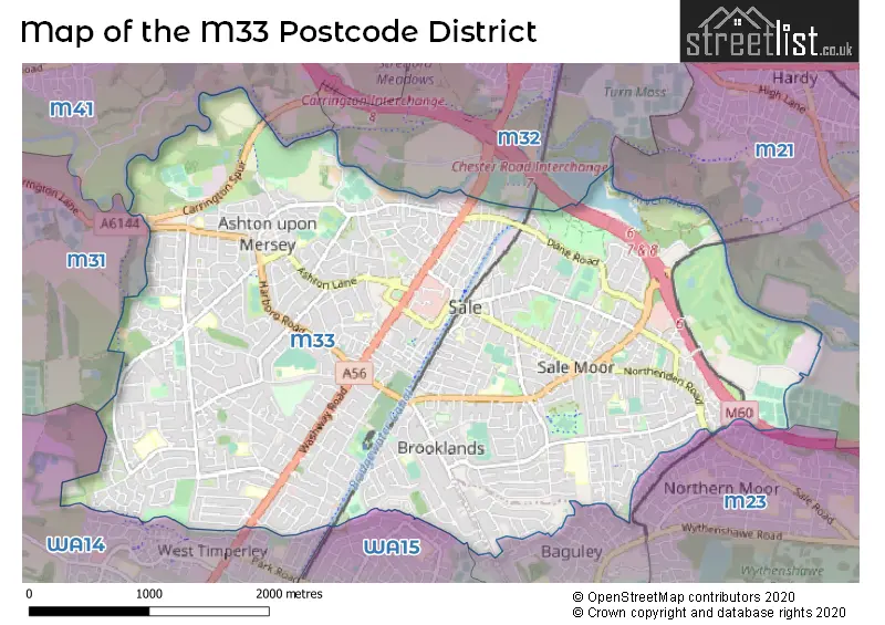
When it comes to local government, postal geography often disregards political borders. However, for a breakdown in the M33 District: the district mostly encompasses the Trafford District (B) (1548 postcodes), and finally, the Manchester District (B) area (20 postcodes).
Recent House Sales in M33
| Date | Price | Address |
|---|---|---|
| 23/10/2023 | £420,000 | Okehampton Crescent, Sale, M33 5HP |
| 16/10/2023 | £480,000 | Brenton Avenue, Sale, M33 6RA |
| 16/10/2023 | £205,000 | Melrose Avenue, Sale, M33 3EZ |
| 13/10/2023 | £320,000 | Marsland Road, Sale, M33 3NX |
| 12/10/2023 | £127,500 | Whitehall Road, Sale, M33 3NL |
| 05/10/2023 | £695,000 | Juniper Close, Sale, M33 6JT |
| 03/10/2023 | £247,500 | Buckfast Road, Sale, M33 5QB |
| 27/09/2023 | £345,000 | Farrier Close, Sale, M33 2ZL |
| 22/09/2023 | £340,000 | Harvest Close, Sale, M33 2LW |
| 22/09/2023 | £124,000 | Abbots Court, Sale, M33 2DB |
Weather Forecast for M33
Press Button to Show Forecast for Sale
| Time Period | Icon | Description | Temperature | Rain Probability | Wind |
|---|---|---|---|---|---|
| 15:00 to 18:00 | Cloudy | 9.0°C (feels like 7.0°C) | 9.00% | SE 9 mph | |
| 18:00 to 21:00 | Cloudy | 8.0°C (feels like 6.0°C) | 49.00% | ENE 9 mph | |
| 21:00 to 00:00 | Cloudy | 7.0°C (feels like 5.0°C) | 5.00% | ENE 7 mph |
Press Button to Show Forecast for Sale
| Time Period | Icon | Description | Temperature | Rain Probability | Wind |
|---|---|---|---|---|---|
| 00:00 to 03:00 | Cloudy | 6.0°C (feels like 4.0°C) | 4.00% | ENE 7 mph | |
| 03:00 to 06:00 | Cloudy | 5.0°C (feels like 3.0°C) | 5.00% | NE 7 mph | |
| 06:00 to 09:00 | Cloudy | 5.0°C (feels like 3.0°C) | 5.00% | NE 7 mph | |
| 09:00 to 12:00 | Cloudy | 8.0°C (feels like 6.0°C) | 5.00% | ENE 9 mph | |
| 12:00 to 15:00 | Cloudy | 10.0°C (feels like 8.0°C) | 10.00% | ENE 9 mph | |
| 15:00 to 18:00 | Overcast | 10.0°C (feels like 8.0°C) | 18.00% | ENE 9 mph | |
| 18:00 to 21:00 | Cloudy | 9.0°C (feels like 7.0°C) | 9.00% | ENE 9 mph | |
| 21:00 to 00:00 | Cloudy | 8.0°C (feels like 6.0°C) | 5.00% | NE 7 mph |
Press Button to Show Forecast for Sale
| Time Period | Icon | Description | Temperature | Rain Probability | Wind |
|---|---|---|---|---|---|
| 00:00 to 03:00 | Cloudy | 6.0°C (feels like 4.0°C) | 4.00% | NNE 7 mph | |
| 03:00 to 06:00 | Cloudy | 6.0°C (feels like 3.0°C) | 6.00% | NNE 7 mph | |
| 06:00 to 09:00 | Cloudy | 6.0°C (feels like 3.0°C) | 12.00% | N 7 mph | |
| 09:00 to 12:00 | Light rain | 8.0°C (feels like 5.0°C) | 44.00% | NNW 7 mph | |
| 12:00 to 15:00 | Light rain | 10.0°C (feels like 7.0°C) | 44.00% | NW 9 mph | |
| 15:00 to 18:00 | Cloudy | 11.0°C (feels like 8.0°C) | 10.00% | WNW 11 mph | |
| 18:00 to 21:00 | Sunny day | 10.0°C (feels like 8.0°C) | 4.00% | W 9 mph | |
| 21:00 to 00:00 | Clear night | 8.0°C (feels like 6.0°C) | 1.00% | SW 7 mph |
Press Button to Show Forecast for Sale
| Time Period | Icon | Description | Temperature | Rain Probability | Wind |
|---|---|---|---|---|---|
| 00:00 to 03:00 | Partly cloudy (night) | 6.0°C (feels like 4.0°C) | 1.00% | SSW 7 mph | |
| 03:00 to 06:00 | Partly cloudy (night) | 5.0°C (feels like 2.0°C) | 1.00% | SSE 7 mph | |
| 06:00 to 09:00 | Cloudy | 6.0°C (feels like 3.0°C) | 5.00% | SSE 9 mph | |
| 09:00 to 12:00 | Partly cloudy (day) | 10.0°C (feels like 8.0°C) | 2.00% | S 11 mph | |
| 12:00 to 15:00 | Overcast | 13.0°C (feels like 10.0°C) | 10.00% | S 13 mph | |
| 15:00 to 18:00 | Cloudy | 14.0°C (feels like 11.0°C) | 10.00% | S 13 mph | |
| 18:00 to 21:00 | Partly cloudy (day) | 13.0°C (feels like 11.0°C) | 6.00% | SSE 11 mph | |
| 21:00 to 00:00 | Clear night | 11.0°C (feels like 8.0°C) | 3.00% | SSE 9 mph |
Press Button to Show Forecast for Sale
| Time Period | Icon | Description | Temperature | Rain Probability | Wind |
|---|---|---|---|---|---|
| 00:00 to 03:00 | Partly cloudy (night) | 9.0°C (feels like 7.0°C) | 4.00% | SE 9 mph | |
| 03:00 to 06:00 | Partly cloudy (night) | 8.0°C (feels like 6.0°C) | 3.00% | SE 9 mph | |
| 06:00 to 09:00 | Sunny day | 9.0°C (feels like 6.0°C) | 3.00% | ESE 9 mph | |
| 09:00 to 12:00 | Sunny day | 13.0°C (feels like 10.0°C) | 4.00% | ESE 11 mph | |
| 12:00 to 15:00 | Partly cloudy (day) | 15.0°C (feels like 12.0°C) | 7.00% | SE 13 mph | |
| 15:00 to 18:00 | Cloudy | 16.0°C (feels like 13.0°C) | 13.00% | SE 11 mph | |
| 18:00 to 21:00 | Partly cloudy (day) | 15.0°C (feels like 13.0°C) | 7.00% | ESE 9 mph | |
| 21:00 to 00:00 | Cloudy | 13.0°C (feels like 11.0°C) | 7.00% | ESE 9 mph |
Where is the M33 Postcode District?
The postcode district M33 is located in Sale, which is a town in the Greater Manchester area. Sale is surrounded by several nearby towns. To the South West is Altrincham, which is approximately 2.78 miles away. To the North East is Manchester, which is about 3.96 miles away. To the South East is Cheadle, approximately 5.19 miles away. To the North is Salford, which is about 5.21 miles away. To the East is Stockport, which is approximately 7.14 miles away. Additionally, Knutsford is located to the South and is about 8.18 miles away. It should be noted that the distance between Sale and London is approximately 161.58 miles.
The district is within the post town of SALE.
The sector has postcodes within the nation of England.
The M33 Postcode District is covers the following regions.
- Greater Manchester South West - Greater Manchester - North West (England)
- Manchester - Greater Manchester - North West (England)
| Postcode Sector | Delivery Office |
|---|---|
| M33 2 | Sale Delivery Office |
| M33 3 | Sale Delivery Office |
| M33 4 | Sale Delivery Office |
| M33 5 | Sale Delivery Office |
| M33 6 | Sale Delivery Office |
| M33 7 | Sale Delivery Office |
| M | 3 | 3 | - | X | X | X |
| M | 3 | 3 | Space | Numeric | Letter | Letter |
Current Monthly Rental Prices
| # Bedrooms | Min Price | Max Price | Avg Price |
|---|---|---|---|
| £700 | £725 | £713 | |
| 1 | £450 | £800 | £683 |
| 2 | £800 | £1,350 | £1,071 |
| 3 | £995 | £1,650 | £1,427 |
| 4 | £1,600 | £2,000 | £1,800 |
Current House Prices
| # Bedrooms | Min Price | Max Price | Avg Price |
|---|---|---|---|
| £475,000 | £475,000 | £475,000 | |
| 1 | £70,000 | £200,000 | £145,154 |
| 2 | £125,000 | £625,000 | £264,805 |
| 3 | £145,000 | £695,000 | £396,117 |
| 4 | £250,000 | £1,200,000 | £607,590 |
| 5 | £520,000 | £1,350,000 | £807,723 |
| 6 | £595,000 | £1,250,000 | £906,875 |
Estate Agents who Operate in the M33 District
| Logo | Name | Brand Name | Address | Contact Number | Total Properties |
|---|---|---|---|---|---|
 | Sale | Gascoigne Halman | 96 School Road, Sale, M33 7XB | 0161 524 1077 | 32 |
 | Sale | Jordan Fishwick | 95-97 School Road Sale M33 7XA | 0161 524 1816 | 30 |
 | Sale | Watersons | 91-93 School Road, Sale, M33 7XA | 0161 524 3200 | 29 |
 | Sale | Bridgfords | 81-83 School Road Sale M33 7XA | 0161 524 8210 | 26 |
 | Sale | Thornley Groves | 100 School Road, Sale, M33 7XB | 0161 509 5932 | 22 |
| Type of Property | 2018 Average | 2018 Sales | 2017 Average | 2017 Sales | 2016 Average | 2016 Sales | 2015 Average | 2015 Sales |
|---|---|---|---|---|---|---|---|---|
| Detached | £482,780 | 146 | £470,139 | 151 | £450,971 | 171 | £395,164 | 175 |
| Semi-Detached | £333,203 | 402 | £330,973 | 427 | £303,312 | 453 | £270,197 | 431 |
| Terraced | £261,361 | 249 | £225,037 | 240 | £221,617 | 275 | £198,803 | 276 |
| Flats | £147,853 | 237 | £147,091 | 297 | £142,399 | 304 | £132,284 | 230 |