The ME19 postcode district is a postal district located in the ME Medway postcode area with a population of 25,616 residents according to the 2021 England and Wales Census.
The area of the ME19 postcode district is 16.35 square miles which is 42.35 square kilometres or 10,465.58 acres.
Currently, the ME19 district has about 699 postcode units spread across 3 geographic postcode sectors.
Given that each sector allows for 400 unique postcode combinations, the district has a capacity of 1,200 postcodes. With 699 postcodes already in use, this leaves 501 units available.
The largest settlement in the ME19 postal code is Kings Hill followed by East Malling, and WEST MALLING.
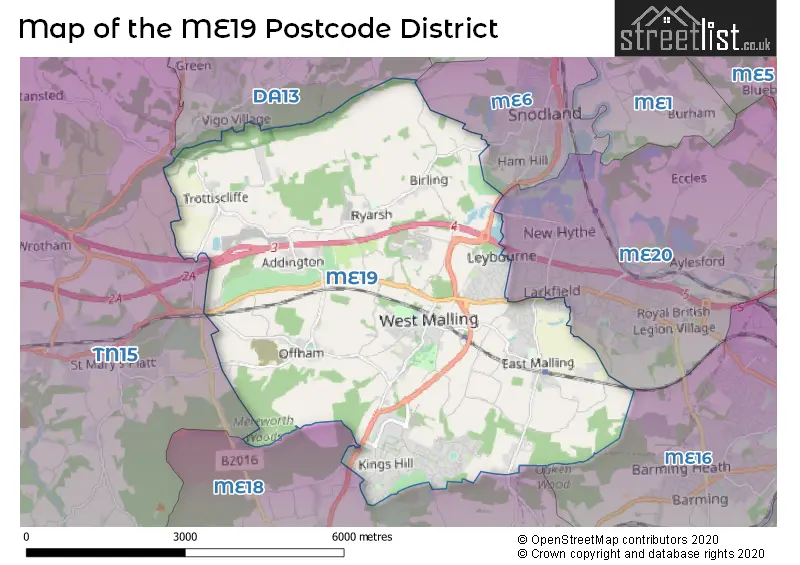
The ME19 Postcode shares a border with DA13 (Meopham, Istead Rise, Southfleet), ME16 (MAIDSTONE, Allington, Barming), ME18 (Wateringbury, Yalding, Mereworth), ME20 (Larkfield, AYLESFORD, Ditton) and TN15 (West Kingsdown, Borough Green, KEMSING).
The primary settlement in the ME19 postcode district is West Malling, located in the county of Kent in England. The most significant Postal Town in this district is West Malling. Other significant settlements in this district include Kings Hill, Addington, Birling, Leybourne, Offham, Ryarsh, Trottiscliffe, and East Malling.
For the district ME19, we have data on 3 postcode sectors. Here's a breakdown: The sector ME19 4, covers Kings Hill and West Malling in Kent. The sector ME19 5, covers Leybourne and Addington and Offham and Ryarsh in Kent. The sector ME19 6, covers East Malling and West Malling in Kent.


Map of the ME19 Postcode District
Explore the ME19 postcode district by using our free interactive map.
When it comes to local government, postal geography often disregards political borders. However, for a breakdown in the ME19 District: the district mostly encompasses the Tonbridge and Malling District (B) area with a total of 743 postcodes.
Recent House Sales in ME19
| Date | Price | Address |
|---|---|---|
| 10/10/2023 | £385,000 | Harvest Ridge, Leybourne, West Malling, ME19 5LZ |
| 06/10/2023 | £555,000 | Atlas Close, Kings Hill, West Malling, ME19 4PS |
| 29/09/2023 | £880,000 | Town Hill, West Malling, ME19 6QL |
| 27/09/2023 | £477,500 | Beacon Avenue, Kings Hill, West Malling, ME19 4LH |
| 25/09/2023 | £480,000 | Regent Way, Kings Hill, West Malling, ME19 4EB |
| 22/09/2023 | £385,000 | Hawley Drive, Leybourne, West Malling, ME19 5FL |
| 20/09/2023 | £280,000 | Millbrook, Leybourne, West Malling, ME19 5QJ |
| 11/09/2023 | £950,000 | Clare Wood Drive, East Malling, West Malling, ME19 6PA |
| 07/09/2023 | £337,500 | Beaufighter Road, West Malling, ME19 4TP |
| 01/09/2023 | £260,700 | Woodlea, Leybourne, West Malling, ME19 5QY |
Weather Forecast for ME19
Press Button to Show Forecast for East Malling
| Time Period | Icon | Description | Temperature | Rain Probability | Wind |
|---|---|---|---|---|---|
| 06:00 to 09:00 | Light rain | 7.0°C (feels like 5.0°C) | 78.00% | NE 4 mph | |
| 09:00 to 12:00 | Overcast | 9.0°C (feels like 7.0°C) | 15.00% | ENE 7 mph | |
| 12:00 to 15:00 | Cloudy | 12.0°C (feels like 11.0°C) | 39.00% | ENE 9 mph | |
| 15:00 to 18:00 | Cloudy | 13.0°C (feels like 11.0°C) | 16.00% | NE 9 mph | |
| 18:00 to 21:00 | Light rain | 11.0°C (feels like 9.0°C) | 59.00% | NE 9 mph | |
| 21:00 to 00:00 | Heavy rain | 10.0°C (feels like 8.0°C) | 92.00% | NE 7 mph |
Press Button to Show Forecast for East Malling
| Time Period | Icon | Description | Temperature | Rain Probability | Wind |
|---|---|---|---|---|---|
| 00:00 to 03:00 | Heavy rain | 10.0°C (feels like 8.0°C) | 93.00% | NE 7 mph | |
| 03:00 to 06:00 | Heavy rain | 10.0°C (feels like 8.0°C) | 80.00% | ESE 7 mph | |
| 06:00 to 09:00 | Light rain | 10.0°C (feels like 8.0°C) | 50.00% | S 7 mph | |
| 09:00 to 12:00 | Light rain | 11.0°C (feels like 9.0°C) | 52.00% | SW 9 mph | |
| 12:00 to 15:00 | Light rain shower (day) | 11.0°C (feels like 8.0°C) | 41.00% | W 13 mph | |
| 15:00 to 18:00 | Cloudy | 11.0°C (feels like 8.0°C) | 14.00% | W 11 mph | |
| 18:00 to 21:00 | Cloudy | 11.0°C (feels like 9.0°C) | 8.00% | WSW 9 mph | |
| 21:00 to 00:00 | Clear night | 8.0°C (feels like 6.0°C) | 2.00% | SW 7 mph |
Press Button to Show Forecast for East Malling
| Time Period | Icon | Description | Temperature | Rain Probability | Wind |
|---|---|---|---|---|---|
| 00:00 to 03:00 | Clear night | 7.0°C (feels like 5.0°C) | 1.00% | SW 4 mph | |
| 03:00 to 06:00 | Clear night | 6.0°C (feels like 4.0°C) | 1.00% | SSW 2 mph | |
| 06:00 to 09:00 | Sunny day | 7.0°C (feels like 6.0°C) | 1.00% | S 4 mph | |
| 09:00 to 12:00 | Cloudy | 12.0°C (feels like 10.0°C) | 4.00% | S 9 mph | |
| 12:00 to 15:00 | Partly cloudy (day) | 15.0°C (feels like 12.0°C) | 2.00% | S 11 mph | |
| 15:00 to 18:00 | Partly cloudy (day) | 15.0°C (feels like 13.0°C) | 2.00% | S 11 mph | |
| 18:00 to 21:00 | Sunny day | 14.0°C (feels like 12.0°C) | 3.00% | S 7 mph | |
| 21:00 to 00:00 | Clear night | 9.0°C (feels like 8.0°C) | 1.00% | SE 4 mph |
Press Button to Show Forecast for East Malling
| Time Period | Icon | Description | Temperature | Rain Probability | Wind |
|---|---|---|---|---|---|
| 00:00 to 03:00 | Partly cloudy (night) | 9.0°C (feels like 7.0°C) | 2.00% | SE 4 mph | |
| 03:00 to 06:00 | Partly cloudy (night) | 8.0°C (feels like 7.0°C) | 3.00% | SE 4 mph | |
| 06:00 to 09:00 | Cloudy | 9.0°C (feels like 8.0°C) | 8.00% | SE 4 mph | |
| 09:00 to 12:00 | Cloudy | 13.0°C (feels like 12.0°C) | 6.00% | SE 7 mph | |
| 12:00 to 15:00 | Cloudy | 16.0°C (feels like 14.0°C) | 10.00% | SE 9 mph | |
| 15:00 to 18:00 | Cloudy | 16.0°C (feels like 15.0°C) | 9.00% | SE 9 mph | |
| 18:00 to 21:00 | Cloudy | 15.0°C (feels like 14.0°C) | 20.00% | ESE 7 mph | |
| 21:00 to 00:00 | Cloudy | 12.0°C (feels like 11.0°C) | 18.00% | ESE 4 mph |
Where is the ME19 Postcode District?
The postcode district for ME19 is located in West Malling. West Malling is in close proximity to several nearby towns, including Snodland to the north-east (2.67 miles away), Aylesford to the east (3.74 miles away), Maidstone to the south-east (6.02 miles away), Longfield to the north-west (7.08 miles away), and Godden Green to the west (7.84 miles away). The distance from West Malling to the centre of London is approximately 26.88 miles.
The district is within the post town of WEST MALLING.
The sector has postcodes within the nation of England.
The ME19 Postcode District is in the West Kent region of Kent within the South East (England).
| Postcode Sector | Delivery Office |
|---|---|
| ME19 4 | Medway Valley Delivery Office |
| ME19 5 | Medway Valley Delivery Office |
| ME19 6 | Medway Valley Delivery Office |
| M | E | 1 | 9 | - | X | X | X |
| M | E | 1 | 9 | Space | Numeric | Letter | Letter |
Current Monthly Rental Prices
| # Bedrooms | Min Price | Max Price | Avg Price |
|---|---|---|---|
| £650 | £650 | £650 | |
| 1 | £770 | £1,100 | £943 |
| 2 | £1,200 | £1,950 | £1,442 |
| 3 | £1,500 | £1,800 | £1,671 |
Current House Prices
| # Bedrooms | Min Price | Max Price | Avg Price |
|---|---|---|---|
| £35,000 | £500,000 | £217,417 | |
| 1 | £215,000 | £274,995 | £244,998 |
| 2 | £188,500 | £725,000 | £311,263 |
| 3 | £231,500 | £1,350,000 | £508,608 |
| 4 | £329,000 | £1,350,000 | £643,389 |
| 5 | £600,000 | £1,875,000 | £892,116 |
| 6 | £925,000 | £1,900,000 | £1,234,000 |
| 9 | £1,125,000 | £1,125,000 | £1,125,000 |
Estate Agents who Operate in the ME19 District
| Logo | Name | Brand Name | Address | Contact Number | Total Properties |
|---|---|---|---|---|---|
 | Kings Hill | Wards | Unit 5a, 7 Liberty Square, Kings Hill, ME19 4AU | 01732 904023 | 31 |
 | Kings Hill | Kings Hill Properties | 8 Liberty Square, Kings Hill, Kent, ME19 4AU | 01732 444240 | 30 |
 | Malling | Simon Miller & Company | The Inn House, 777 London Road, Larkfield, ME20 6DE | 01732 444827 | 16 |
 | West Malling | KHP Country Homes | 75-77 High Street, West Malling, ME19 6NA | 01732 444971 | 15 |
 | Worthing | Homewise | 1 Liverpool Gardens Worthing BN11 1TF | 01903 497338 | 13 |
| Type of Property | 2018 Average | 2018 Sales | 2017 Average | 2017 Sales | 2016 Average | 2016 Sales | 2015 Average | 2015 Sales |
|---|---|---|---|---|---|---|---|---|
| Detached | £578,795 | 183 | £580,678 | 208 | £528,119 | 225 | £520,230 | 224 |
| Semi-Detached | £387,994 | 106 | £379,511 | 128 | £382,618 | 131 | £354,294 | 119 |
| Terraced | £321,203 | 127 | £323,970 | 147 | £321,646 | 128 | £280,500 | 159 |
| Flats | £261,400 | 69 | £248,661 | 124 | £238,437 | 89 | £238,631 | 64 |