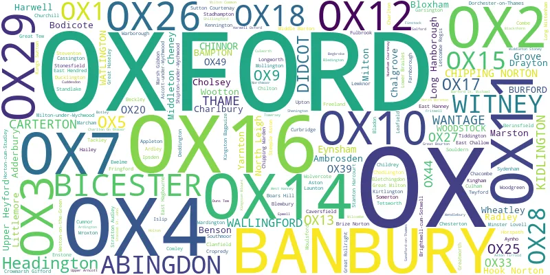
This section of the site is all about the OX Postcode area, also known as the Oxford Postal Area. Explore links to the next level to learn more about specific postcode districts such as OX1.
Quick Facts about the OX Postcode
| Width from East to West | 37.79 mi |
| Height from North to South | 46.28 mi |
| Area of OX | 829.14 mi² |
| Maximum Width | 46.39 mi |
| Perimeter of Postcode Area | 246.45 mi |
| Number of Postcode Districts | 26 |
| Number of Postcode Sectors | 119 |
| Number of Post Towns | 17 |
| Number of Postcodes | 19,990 |
OX Postal Area
-
The letters OX represent the Oxford postcode area. The area has 26 postcode districts divided between 17 post towns. 97% of all postcodes are within the county of Oxfordshire which can be abbreviated to Oxon when addressing mail.
The district OX27 in the Bicester Post town has 16% of postcodes within Buckinghamshire or Bucks.
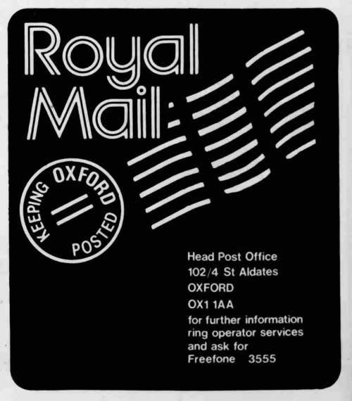
Post Office Headquarters
-
The Head Post Office for the area is located at 102/104 St Aldates, Oxford, OX1 1AA. The post office is an imposing gothic arched Victorian building built in 1878.
The building looks more like a town hall or a cathedral than a post office with its carved granite columns and elaborate coats of arms.
Geographical Information
-
The perimeter of the OX postcode area measures 246.5 Miles and has an area of 922.5 square miles. It is 46 miles long at its widest point.
-
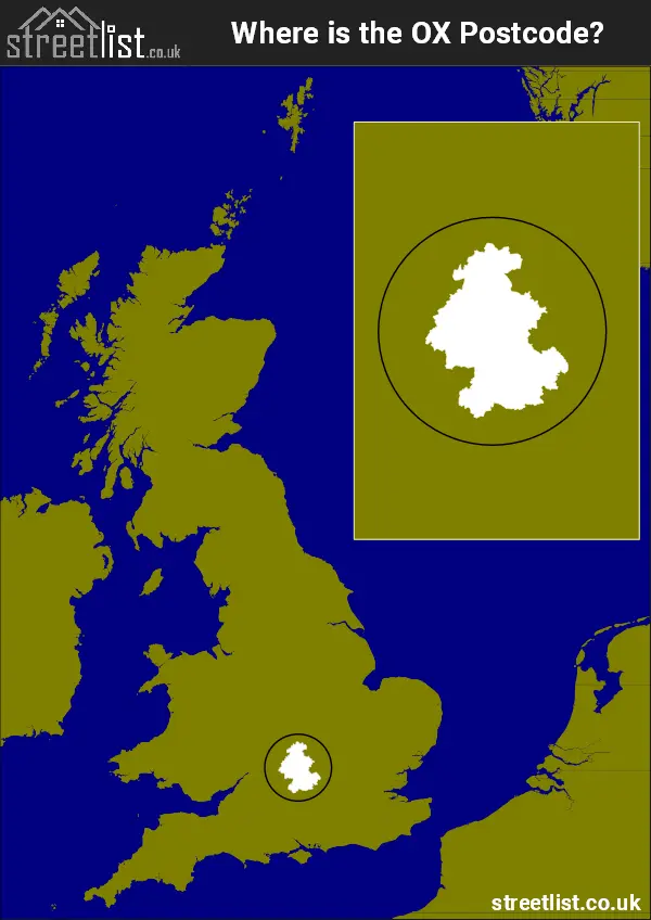
The postcode is located between Coventry and London in the South East of England
-
The area has roughly 20,000 postcode units.
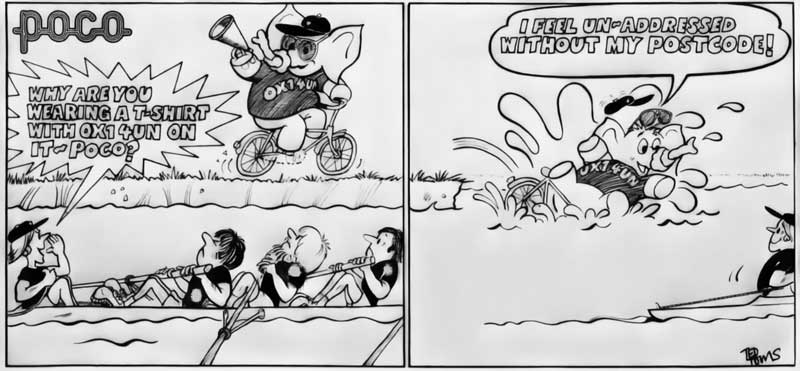
History of Oxford Postcode
-
The Oxford postcode was introduced in around 1972 after a local newspaper campaign educating residents of the importance of using the postcode.
-
A cartoon elephant with its trunk tied in its trunk was used as a mascot and named Poco. The slogan was 'Don't forget the postcode'.

Cartoon Mascot
-
A cartoon used in the Oxford area can be seen below.
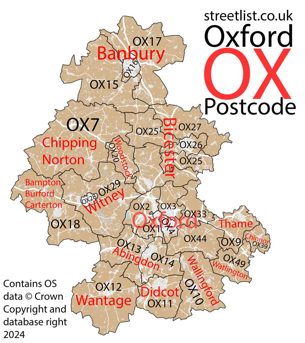
Map of the OX Oxford Postcode Area
Explore the OX Oxford postcode area by using our interactive map.
How built up is the OX Postcode?
I've calculated the total area covered by building footprints within the OX postcode area.
By analyzing this against the total area, I've determined the percentage of the area that's developed, this will give you an idea of how urban or rural the OX postcode region is.
The higher the percentage the more urban the area is. For example the least urban district is OX49 and the most urban is OX16.
| Postcode District | Total Area (m²) | Footprint Area (m²) | Built Percentage % |
|---|---|---|---|
| OX49 | 60,315,149 | 392,646 | 0.65% |
| OX27 | 101,741,228 | 723,159 | 0.71% |
| OX7 | 289,469,041 | 2,128,792 | 0.74% |
| OX20 | 49,083,730 | 385,290 | 0.78% |
| OX44 | 78,574,855 | 661,585 | 0.84% |
| OX17 | 190,776,299 | 1,741,524 | 0.91% |
| OX15 | 189,250,018 | 1,830,980 | 0.97% |
| OX12 | 175,005,068 | 1,842,075 | 1.05% |
| OX33 | 50,089,490 | 566,265 | 1.13% |
| OX18 | 164,876,816 | 1,910,304 | 1.16% |
| OX29 | 183,122,987 | 2,248,505 | 1.23% |
| OX25 | 115,443,587 | 1,457,357 | 1.26% |
| OX13 | 89,780,893 | 1,245,060 | 1.39% |
| OX39 | 27,826,816 | 418,786 | 1.50% |
| OX10 | 122,388,236 | 1,871,428 | 1.53% |
| OX9 | 65,195,596 | 1,004,412 | 1.54% |
| OX5 | 91,896,435 | 1,468,103 | 1.60% |
| OX11 | 84,938,871 | 2,480,989 | 2.92% |
| OX2 | 50,641,165 | 1,948,938 | 3.85% |
| OX14 | 66,857,267 | 2,689,067 | 4.02% |
| OX3 | 41,091,781 | 1,747,560 | 4.25% |
| OX1 | 23,899,234 | 1,217,599 | 5.09% |
| OX26 | 32,187,397 | 1,984,062 | 6.16% |
| OX4 | 20,274,045 | 2,550,439 | 12.58% |
| OX28 | 8,928,141 | 1,169,435 | 13.10% |
| OX16 | 19,227,225 | 2,596,057 | 13.50% |
| OX Total | 2,392,881,370 (m²) | 40,280,417 (m²) | 1.68% |
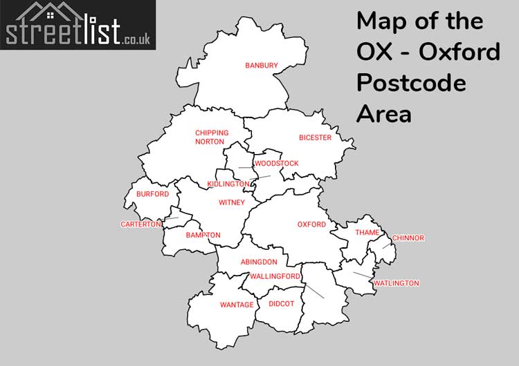
Postcode Districts within the OX Oxford Postcode Area
There are 26 postcode districts within the Oxford postcode area
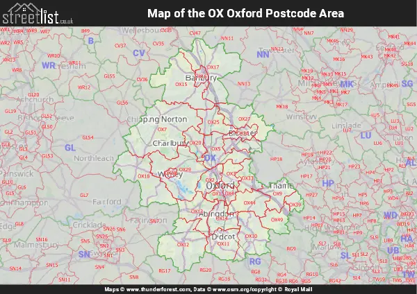
A map showing the boundary of OX in relation to other areas
There are 15 towns within the Oxford postcode area.
| Unit | Area² |
|---|---|
| Hectares | 2,392,888² |
| Miles | 9,239² |
| Feet | 257,568,071,432² |
| Kilometres | 23,929² |
Postal Delivery Offices serving the OX Oxford Postcode Area
- Abingdon Delivery Office
- Banbury Delivery Office
- Bicester Delivery Office
- Carterton Delivery Office
- Chalgrove Scale Payment Delivery Office
- Chinnor Scale Payment Delivery Office
- Chipping Norton Delivery Office
- Didcot Delivery Office
- East Oxford Delivery Office
- Headington Delivery Office
- Kidlington Delivery Office
- Oxford Delivery Office
- Thame Delivery Office
- Wallingford Delivery Office
- Wantage Delivery Office
- Watlington (ox49) Delivery Office
- Wheatley Scale Payment Delivery Office
- Witney Delivery Office
- Woodstock Scale Payment Delivery Office
Councils with Postcodes in OX
Towns and Villages within the OX Oxford Postcode Area
- Abingdon-on-Thames - town
- Adderbury - village
- Alkerton - village
- Alvescot - village
- Ambrosden - village
- Appleford-on-Thames - village
- Appleton - village
- Ardington - village
- Ardley - village
- Ascott-under-Wychwood - village
- Aston - village
- Aston Rowant - village
- Aston Tirrold - village
- Aston Upthorpe - village
- Balscote - village
- Bampton - village
- Banbury - town
- Barford St Michael - village
- Bayworth - village
- Beckley - village
- Begbroke - village
- Benson - village
- Berinsfield - village
- Bicester - town
- Black Bourton - village
- Blackthorn - village
- Bladon - village
- Bledington - village
- Bletchingdon - village
- Blewbury - village
- Bloxham - village
- Boars Hill - village
- Bodicote - village
- Bradwell - village
- Brighthampton - village
- Brightwell-cum-Sotwell - village
- Britwell Salome - village
- Brize Norton - village
- Brookhampton - village
- Broughton - village
- Bucknell - village
- Burcot - village
- Burdrop - village
- Burford - town
- Carterton - town
- Cassington - village
- Caulcott - village
- Chacombe - village
- Chadlington - village
- Chalgrove - village
- Charlbury - town
- Charlton - village
- Charlton-on-Otmoor - village
- Charndon - village
- Charney Bassett - village
- Chawley - village
- Chesterton - village
- Childrey - village
- Chilton - village
- Chinnor - village
- Chipping Norton - town
- Chipping Warden - village
- Cholsey - village
- Church Hanborough - village
- Church Westcote - village
- Churchill - village
- Clanfield - village
- Claydon - village
- Clifton - village
- Clifton Hampden - village
- Combe - village
- Cote - village
- Cothill - village
- Crawley - village
- Cropredy - village
- Crowell - village
- Crowmarsh Gifford - village
- Cuddesdon - village
- Culham - village
- Culworth - village
- Cumnor - village
- Curbridge - village
- Cuxham - village
- Deddington - village
- Delly End - village
- Denchworth - village
- Didcot - town
- Dorchester - village
- Drayton - village
- Drayton - village
- Drayton St Leonard - village
- Ducklington - village
- Duns Tew - village
- East Challow - village
- East End - village
- East Hagbourne - village
- East Hanney - village
- East Hendred - village
- East Lockinge - village
- Elsfield - village
- Emmington - village
- Enstone - village
- Epwell - village
- Ewelme - village
- Eynsham - village
- Farmoor - village
- Farnborough - village
- Farnborough - village
- Fawley - village
- Fewcott - village
- Fifield - village
- Finstock - village
- Forest Hill - village
- Freeland - village
- Frilford - village
- Fringford - village
- Fritwell - village
- Fulbrook - village
- Fyfield - village
- Garford - village
- Garsington - village
- Great Barrington - village
- Great Bourton - village
- Great Haseley - village
- Great Milton - village
- Great Rollright - village
- Great Tew - village
- Greatworth - village
- Grove - village
- Hailey - village
- Hampton Poyle - village
- Hanwell - village
- Harwell - village
- Hempton - village
- Henton - village
- Henwood - village
- Hethe - village
- Holton - village
- Hook Norton - village
- Horley - village
- Hornton - village
- Horspath - village
- Horton-cum-Studley - village
- Idbury - village
- Ipsden - village
- Islip - village
- Kennington - village
- Kidlington - town
- Kingham - village
- Kings Sutton - village
- Kingston Bagpuize - village
- Kingston Blount - village
- Kingston Lisle - village
- Kirtlington - village
- Launton - village
- Leafield - village
- Letcombe Bassett - village
- Letcombe Regis - village
- Lewknor - village
- Little Barrington - village
- Little Bourton - village
- Little Milton - village
- Little Tew - village
- Littleworth - village
- Long Hanborough - village
- Long Wittenham - village
- Longworth - village
- Lower Brailes - village
- Lower Heyford - village
- Lower Tadmarton - village
- Lyneham - village
- Marcham - village
- Marsh Baldon - village
- Marsh Gibbon - village
- Marston St Lawrence - village
- Merton - village
- Middle Aston - village
- Middle Barton - village
- Middleton Cheney - village
- Middleton Stoney - village
- Milcombe - village
- Milton - village
- Milton - village
- Milton Common - village
- Milton Heights - village
- Milton Hill - otherSettlement
- Milton-under-Wychwood - village
- Minster Lovell - village
- Mollington - village
- Mongewell - village
- Moreton - village
- Moulsford - village
- New Yatt - village
- Newington - village
- Noke - village
- North Aston - village
- North Leigh - village
- North Moreton - village
- North Newington - village
- North Stoke - village
- Northmoor - village
- Nuneham Courtenay - village
- Oddington - village
- Over Norton - village
- Overthorpe - village
- Oxford - city
- Oxford Spires Park - otherSettlement
- Piddington - village
- Poffley End - village
- Postcombe - village
- Poundon - village
- Pyrton - village
- Radley - village
- Ramsden - village
- Rowstock - village
- Salford - village
- Sandford St Martin - village
- Sandford-on-Thames - village
- Sarsden - otherSettlement
- Shenington - village
- Shillingford - village
- Shilton - village
- Shippon - village
- Shipton-on-Cherwell - village
- Shipton-under-Wychwood - village
- Shirburn - village
- Shotteswell - village
- Shutford - village
- Sibford Ferris - village
- Sibford Gower - village
- Somerton - village
- Souldern - village
- South Hinksey - village
- South Leigh - village
- South Moreton - village
- South Newington - village
- Sparsholt - village
- Spelsbury - village
- Stadhampton - village
- Standlake - village
- Stanton Harcourt - village
- Stanton St John - village
- Steeple Aston - village
- Steventon - village
- Stoke Lyne - village
- Stonesfield - village
- Stratton Audley - village
- Sunningwell - village
- Sutton - village
- Sutton Courtenay - village
- Sutton-under-Brailes - village
- Swalcliffe - village
- Swerford - village
- Swinbrook - village
- Sydenham - village
- Tackley - village
- Tadmarton - village
- Tetsworth - village
- Thame - town
- Thorpe Mandeville - village
- Thrupp - village
- Tiddington - village
- Towersey - village
- Tubney - village
- Twyford - village
- Upper Arncott - village
- Upper Brailes - village
- Upper Heyford - village
- Upper Wardington - village
- Upperton - village
- Upton - village
- Wallingford - town
- Wantage - town
- Warborough - village
- Wardington - village
- Warmington - village
- Waterperry - village
- Watlington - town
- Wendlebury - village
- West Challow - village
- West Hagbourne - village
- West Hanney - village
- West Hendred - village
- Weston-on-the-Green - village
- Wheatley - village
- Wigginton - village
- Winderton - village
- Windrush - village
- Witney - town
- Wolvercote - village
- Woodstock - town
- Wootton - village
- Wootton - village
- Wroxton - village
- Wytham - village
- Yarnton - village