The N19 postcode district is a postal district located in the N London - N postcode area with a population of 35,005 residents according to the 2021 England and Wales Census.
The area of the N19 postcode district is 0.95 square miles which is 2.46 square kilometres or 607.47 acres.
Currently, the N19 district has about 647 postcode units spread across 3 geographic postcode sectors.
Given that each sector allows for 400 unique postcode combinations, the district has a capacity of 1,200 postcodes. With 647 postcodes already in use, this leaves 553 units available.
The N19 postal code covers the settlement of ISLINGTON.
The N19 Postcode shares a border with N6 (HORNSEY, LONDON), NW5 (LONDON), N4 (HACKNEY, HORNSEY, ISLINGTON), N7 (ISLINGTON) and N8 (HORNSEY).
The primary settlement in the N19 postcode district is Islington, which is located in the county of Greater London. Other significant settlements in the district include Camden. The most significant post town in the N19 postcode district is London.
For the district N19, we have data on 4 postcode sectors. Here's a breakdown: The sector N19 3, covers Islington in Greater London. The sector N19 4, covers Islington in Greater London. The sector N19 5, covers Islington and Camden in Greater London. The sector N19 9 is non-geographic. It's often designated for PO Boxes, large organisations, or special services.

Map of the N19 Postcode District
Explore the N19 postcode district by using our free interactive map.
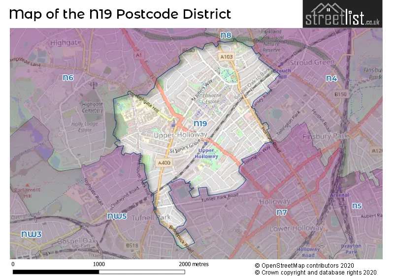
When it comes to local government, postal geography often disregards political borders. However, for a breakdown in the N19 District: the district mostly encompasses the Islington London Boro (613 postcodes), and finally, the Camden London Boro area (31 postcodes).
Recent House Sales in N19
| Date | Price | Address |
|---|---|---|
| 12/10/2023 | £438,000 | Hugo Road, London, N19 5EU |
| 11/09/2023 | £515,000 | Miranda Road, London, N19 3RA |
| 08/09/2023 | £435,000 | Lambton Road, London, N19 3QH |
| 07/09/2023 | £925,000 | Tufnell Park Road, London, N19 5EW |
| 05/09/2023 | £425,000 | Goddard Place, London, N19 5GT |
| 01/09/2023 | £490,000 | Goddard Place, London, N19 5GS |
| 01/09/2023 | £625,000 | Shaftesbury Road, London, N19 4QN |
| 31/08/2023 | £2,000,000 | Mercers Road, London, N19 4PP |
| 25/08/2023 | £570,000 | Hazellville Road, London, N19 3BP |
| 25/08/2023 | £585,000 | Goddard Place, London, N19 5GS |
Weather Forecast for N19
Press Button to Show Forecast for Arsenal F.C.
| Time Period | Icon | Description | Temperature | Rain Probability | Wind |
|---|---|---|---|---|---|
| 12:00 to 15:00 | Cloudy | 10.0°C (feels like 10.0°C) | 5.00% | E 2 mph | |
| 15:00 to 18:00 | Cloudy | 12.0°C (feels like 11.0°C) | 5.00% | ESE 4 mph | |
| 18:00 to 21:00 | Cloudy | 11.0°C (feels like 9.0°C) | 6.00% | E 9 mph | |
| 21:00 to 00:00 | Cloudy | 9.0°C (feels like 7.0°C) | 7.00% | E 9 mph |
Press Button to Show Forecast for Arsenal F.C.
| Time Period | Icon | Description | Temperature | Rain Probability | Wind |
|---|---|---|---|---|---|
| 00:00 to 03:00 | Light rain | 8.0°C (feels like 6.0°C) | 47.00% | ENE 9 mph | |
| 03:00 to 06:00 | Heavy rain | 7.0°C (feels like 5.0°C) | 85.00% | NE 9 mph | |
| 06:00 to 09:00 | Light rain | 7.0°C (feels like 4.0°C) | 62.00% | NE 9 mph | |
| 09:00 to 12:00 | Overcast | 8.0°C (feels like 5.0°C) | 44.00% | NE 9 mph | |
| 12:00 to 15:00 | Overcast | 11.0°C (feels like 9.0°C) | 13.00% | NE 9 mph | |
| 15:00 to 18:00 | Cloudy | 12.0°C (feels like 11.0°C) | 16.00% | NE 7 mph | |
| 18:00 to 21:00 | Light rain | 12.0°C (feels like 10.0°C) | 81.00% | NE 9 mph | |
| 21:00 to 00:00 | Heavy rain | 10.0°C (feels like 8.0°C) | 91.00% | NE 9 mph |
Press Button to Show Forecast for Arsenal F.C.
| Time Period | Icon | Description | Temperature | Rain Probability | Wind |
|---|---|---|---|---|---|
| 00:00 to 03:00 | Heavy rain | 9.0°C (feels like 7.0°C) | 91.00% | NNE 9 mph | |
| 03:00 to 06:00 | Heavy rain | 9.0°C (feels like 7.0°C) | 92.00% | NE 9 mph | |
| 06:00 to 09:00 | Heavy rain | 9.0°C (feels like 7.0°C) | 83.00% | NNW 7 mph | |
| 09:00 to 12:00 | Heavy rain | 9.0°C (feels like 7.0°C) | 84.00% | W 9 mph | |
| 12:00 to 15:00 | Light rain | 9.0°C (feels like 7.0°C) | 57.00% | WNW 11 mph | |
| 15:00 to 18:00 | Cloudy | 10.0°C (feels like 8.0°C) | 14.00% | W 11 mph | |
| 18:00 to 21:00 | Cloudy | 11.0°C (feels like 9.0°C) | 8.00% | WSW 9 mph | |
| 21:00 to 00:00 | Partly cloudy (night) | 10.0°C (feels like 8.0°C) | 4.00% | SW 7 mph |
Press Button to Show Forecast for Arsenal F.C.
| Time Period | Icon | Description | Temperature | Rain Probability | Wind |
|---|---|---|---|---|---|
| 00:00 to 03:00 | Clear night | 8.0°C (feels like 7.0°C) | 2.00% | SW 4 mph | |
| 03:00 to 06:00 | Clear night | 7.0°C (feels like 6.0°C) | 1.00% | SSW 4 mph | |
| 06:00 to 09:00 | Sunny day | 7.0°C (feels like 6.0°C) | 1.00% | S 4 mph | |
| 09:00 to 12:00 | Partly cloudy (day) | 12.0°C (feels like 10.0°C) | 1.00% | S 9 mph | |
| 12:00 to 15:00 | Partly cloudy (day) | 15.0°C (feels like 12.0°C) | 4.00% | S 11 mph | |
| 15:00 to 18:00 | Partly cloudy (day) | 15.0°C (feels like 13.0°C) | 3.00% | S 11 mph | |
| 18:00 to 21:00 | Sunny day | 14.0°C (feels like 12.0°C) | 3.00% | S 9 mph | |
| 21:00 to 00:00 | Clear night | 12.0°C (feels like 10.0°C) | 1.00% | SSE 7 mph |
Press Button to Show Forecast for Arsenal F.C.
| Time Period | Icon | Description | Temperature | Rain Probability | Wind |
|---|---|---|---|---|---|
| 00:00 to 03:00 | Clear night | 10.0°C (feels like 9.0°C) | 1.00% | SE 7 mph | |
| 03:00 to 06:00 | Clear night | 9.0°C (feels like 8.0°C) | 2.00% | ESE 7 mph | |
| 06:00 to 09:00 | Cloudy | 9.0°C (feels like 8.0°C) | 7.00% | ESE 7 mph | |
| 09:00 to 12:00 | Cloudy | 13.0°C (feels like 12.0°C) | 5.00% | ESE 7 mph | |
| 12:00 to 15:00 | Cloudy | 16.0°C (feels like 14.0°C) | 9.00% | SE 9 mph | |
| 15:00 to 18:00 | Cloudy | 17.0°C (feels like 15.0°C) | 10.00% | SE 9 mph | |
| 18:00 to 21:00 | Cloudy | 16.0°C (feels like 14.0°C) | 10.00% | SE 9 mph | |
| 21:00 to 00:00 | Light rain shower (night) | 14.0°C (feels like 12.0°C) | 34.00% | ESE 7 mph |
Where is the N19 Postcode District?
The postcode district N19 is located in the town of London. It is situated approximately 4.02 miles away from the center of London. N19 is surrounded by several nearby towns including Hornsey to the north, Islington to the southeast, Camden Town to the south, Hampstead to the west, First Section Up to Number One to the northwest, and Regents Park to the southwest.
The district is within the post town of LONDON.
The sector has postcodes within the nation of England.
The N19 Postcode District is covers the following regions.
- Haringey and Islington - Inner London - East - London
- Camden and City of London - Inner London - West - London
| Postcode Sector | Delivery Office |
|---|---|
| N19 3 | Upper Holloway Sdelivery Office |
| N19 4 | Upper Holloway Sdelivery Office |
| N19 5 | Upper Holloway Sdelivery Office |
| N | 1 | 9 | - | X | X | X |
| N | 1 | 9 | Space | Numeric | Letter | Letter |
Current Monthly Rental Prices
| # Bedrooms | Min Price | Max Price | Avg Price |
|---|---|---|---|
| £800 | £2,300 | £1,285 | |
| 1 | £825 | £5,941 | £2,049 |
| 2 | £1,700 | £7,512 | £2,805 |
| 3 | £2,817 | £5,376 | £3,156 |
| 4 | £3,250 | £5,250 | £4,237 |
| 5 | £4,600 | £5,250 | £4,925 |
| 6 | £6,000 | £6,851 | £6,600 |
Current House Prices
| # Bedrooms | Min Price | Max Price | Avg Price |
|---|---|---|---|
| £230,000 | £1,500,000 | £588,750 | |
| 1 | £225,000 | £585,000 | £400,642 |
| 2 | £300,000 | £1,100,000 | £600,578 |
| 3 | £460,000 | £1,500,000 | £833,832 |
| 4 | £550,000 | £2,850,000 | £1,247,380 |
| 5 | £1,100,000 | £1,700,000 | £1,410,714 |
| 7 | £2,500,000 | £2,500,000 | £2,500,000 |
Estate Agents who Operate in the N19 District
| Logo | Name | Brand Name | Address | Contact Number | Total Properties |
|---|---|---|---|---|---|
 | Vonder | Vonder | 60 Welbeck Street, London, W1G 9XB | 020 3871 0492 | 21 |
 | Dartmouth Park & Tufnell Park | Dexters | 64 Chetwynd Road, London, NW5 1DE | 020 7284 0101 | 20 |
 | London | JTM Homes | 695 Holloway Road London N19 5SE | 020 3907 2747 | 16 |
 | London - Holloway Road | David Andrew | 671 Holloway Road, London, N19 5SE | 020 3840 3854 | 12 |
 | Camden | Foxtons | 120 Parkway, London, NW1 7AN | 020 3907 2633 | 11 |
| Type of Property | 2018 Average | 2018 Sales | 2017 Average | 2017 Sales | 2016 Average | 2016 Sales | 2015 Average | 2015 Sales |
|---|---|---|---|---|---|---|---|---|
| Detached | £1,272,500 | 1 | £960,000 | 1 | £0 | 0 | £1,350,000 | 2 |
| Semi-Detached | £1,214,167 | 6 | £1,599,042 | 12 | £1,060,829 | 13 | £982,500 | 8 |
| Terraced | £1,029,769 | 50 | £1,132,761 | 43 | £1,027,021 | 52 | £1,009,549 | 74 |
| Flats | £470,717 | 235 | £498,658 | 155 | £492,863 | 230 | £451,381 | 225 |