This section of the site is all about the PR Postcode area, also known as the Preston Postal Area. Explore links to the next level to learn more about specific postcode districts such as PR1.
The PR postcode area represents a group of postal districts in the Preston area of the United Kingdom. The area code PR stands for the letters p and r in PReston. PR has a population of 520,556 and covers an area of 976,396 hectares. Fun fact: 0.80% of the population of Great Britain lives in this area.
The postcode area falls within the following counties: Lancashire (83.91%), Merseyside (16.08%), North Yorkshire (0.01%).
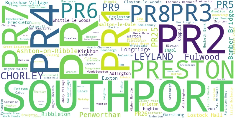
Post Towns and Postcode Districts for the PR Postcode
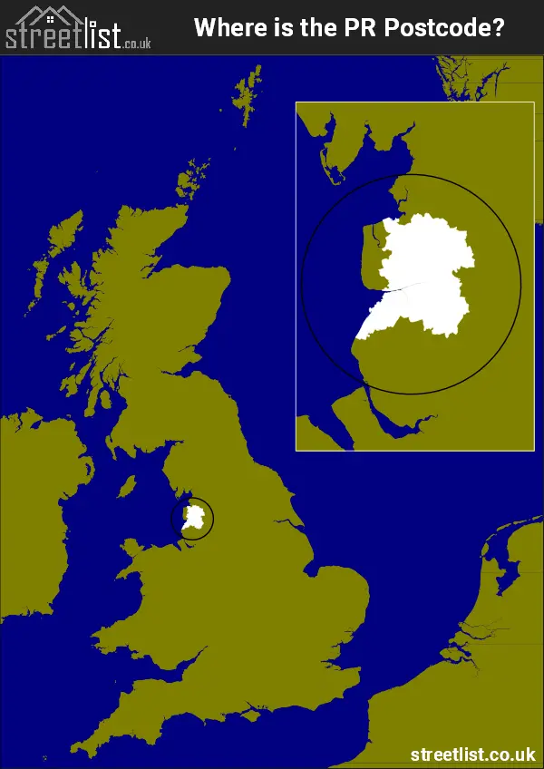
Where is the PR Postcode Area?
The Preston PR Postcode is in the North West of England. ThePR postal area borders the following neighbouring postal areas: LA - Lancaster, WN - Wigan, FY - The Fylde, BL - Bolton, BB - Blackburn and L - Liverpool, It also borders The Irish Sea and Morecambe Bay.
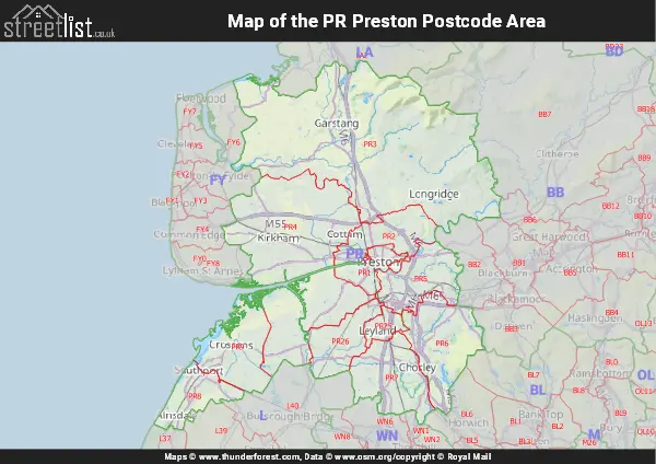
Map of the PR Preston Postcode Area
Explore the PR Preston postcode area by using our interactive map.
How built up is the PR Postcode?
I've calculated the total area covered by building footprints within the PR postcode area.
By analyzing this against the total area, I've determined the percentage of the area that's developed, this will give you an idea of how urban or rural the PR postcode region is.
The higher the percentage the more urban the area is. For example the least urban district is PR3 and the most urban is PR1.
| Postcode District | Total Area (m²) | Footprint Area (m²) | Built Percentage % |
|---|---|---|---|
| PR3 | 359,625,393 | 4,465,017 | 1.24% |
| PR4 | 218,214,134 | 5,313,558 | 2.44% |
| PR6 | 71,643,590 | 2,046,050 | 2.86% |
| PR26 | 39,768,144 | 1,310,532 | 3.30% |
| PR9 | 61,530,651 | 2,096,600 | 3.41% |
| PR5 | 50,343,610 | 2,554,536 | 5.07% |
| PR7 | 61,766,626 | 3,377,011 | 5.47% |
| PR8 | 35,418,404 | 2,745,069 | 7.75% |
| PR2 | 44,181,034 | 3,840,405 | 8.69% |
| PR25 | 12,557,852 | 1,599,115 | 12.73% |
| PR1 | 20,789,287 | 3,120,950 | 15.01% |
| PR Total | 975,838,725 (m²) | 32,468,843 (m²) | 3.33% |
Postcode Districts within the PR Preston Postcode Area
There are 11 postcode districts within the Preston postcode area
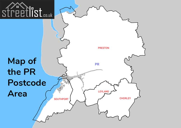
A map showing the boundary of PR in relation to other areas
There are 10 towns within the Preston postcode area.
| Unit | Area² |
|---|---|
| Hectares | 976,396² |
| Miles | 3,770² |
| Feet | 105,098,289,044² |
| Kilometres | 9,764² |
Postal Delivery Offices serving the PR Preston Postcode Area
- Chorley Delivery Office
- Garstang Delivery Office
- Hesketh Bank Scale Payment Delivery Office
- Leyland Delivery Office
- Longridge Delivery Office
- New Longton Scale Payment Delivery Office
- Preston Central Delivery Office
- Preston South Delivery Office
- Preston West Delivery Office
- Southport Delivery Office
Councils with Postcodes in PR
Towns and Villages within the PR Preston Postcode Area
- Abbey Village - village
- Adlington - town
- Andertons Mill - village
- Bamber Bridge - town
- Banks - village
- Barton - village
- Becconsall - village
- Bilsborrow - village
- Bonds - village
- Bowgreave - village
- Bretherton - village
- Brindle - village
- Brinscall - village
- Broughton - village
- Cabus - village
- Calder Vale - village
- Carr Cross - village
- Catforth - village
- Catterall - village
- Charnock Richard - village
- Chipping - village
- Chorley - town
- Churchtown - village
- Clifton - village
- Copp - village
- Coppull - village
- Coppull Moor - village
- Coup Green - village
- Cow Hill - village
- Crossmoor - otherSettlement
- Croston - village
- Cumeragh Village - village
- Eccleston - village
- Elswick - village
- Esprick - village
- Euxton - village
- Farington - village
- Fisher's Row - village
- Forton - village
- Freckleton - town
- Fulwood - town
- Garstang - town
- Goosnargh - village
- Great Eccleston - village
- Great Plumpton - village
- Gregson Lane - village
- Grimeford Village - village
- Grimsargh - village
- Heath Charnock - village
- Hesketh Bank - village
- Heskin Green - village
- Higher Walton - village
- Higher Wheelton - village
- Hoghton - village
- Hundred End - village
- Hutton - village
- Inskip - village
- Inskip Moss Side - otherSettlement
- Johnson's Hillock - village
- Kirkham - town
- Knowle Green - village
- Lea Town - village
- Leyland - town
- Little Eccleston - village
- Little Hoole Moss Houses - village
- Longridge - town
- Longton - village
- Mere Brow - village
- Midge Hall - village
- Much Hoole - village
- Nab's Head - village
- New Gate - village
- New Longton - village
- Newsham - village
- Newton-with-Scales - village
- Out Rawcliffe - village
- Penwortham - Settlement
- Pilling - village
- Pincock - village
- Preston - city
- Ribby - otherSettlement
- Ribchester - village
- Runshaw Moor - village
- Salwick - village
- Samlesbury - village
- Scorton - village
- Smallwood Hey - village
- Southport - town
- St Michael's on Wyre - village
- Stake Pool - village
- Swillbrook - village
- Tarleton - village
- Treales - village
- Ulnes Walton - village
- Walmer Bridge - village
- Warton - village
- Weeton - village
- Wesham - village
- Wharles - village
- Wheelton - village
- White Stake - village
- Whittingham - village
- Whittle-le-Woods - village
- Withnell - village
- Withnell Fold - village
- Woodplumpton - village
- Worden - village
- Wrea Green - village
- Wrightington Bar - village
- Wymott - village