The N22 postcode district is a postal district located in the N London - N postcode area with a population of 43,559 residents according to the 2021 England and Wales Census.
The area of the N22 postcode district is 1.89 square miles which is 4.90 square kilometres or 1,210.46 acres.
Currently, the N22 district has about 693 postcode units spread across 4 geographic postcode sectors.
Given that each sector allows for 400 unique postcode combinations, the district has a capacity of 1,600 postcodes. With 693 postcodes already in use, this leaves 907 units available.
The N22 postal code covers the settlement of WOOD GREEN.
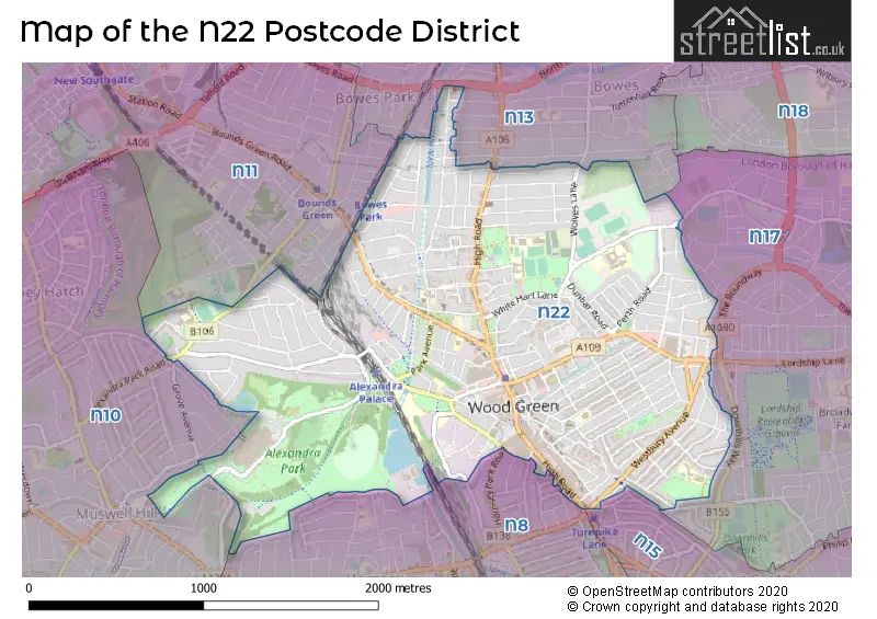
The N22 Postcode shares a border with N10 (HORNSEY, MUSWELL HILL), N15 (TOTTENHAM), N17 (TOTTENHAM), N8 (HORNSEY), N11 (NEW SOUTHGATE, SOUTHGATE, WOOD GREEN) and N13 (SOUTHGATE).
The primary settlement in the N22 postcode district is Haringey in Greater London, with a count of 196. Other significant settlements include Enfield, also in Greater London, with a count of 18. The most significant post town in this postcode district is London.
For the district N22, we have data on 5 postcode sectors. Here's a breakdown: The sector N22 5, covers Haringey in Greater London. The sector N22 6, covers Haringey in Greater London. The sector N22 7, covers Haringey in Greater London. The sector N22 8, covers Haringey and Enfield in Greater London. The sector N22 9 is non-geographic. It's often designated for PO Boxes, large organisations, or special services.


Map of the N22 Postcode District
Explore the N22 postcode district by using our free interactive map.
When it comes to local government, postal geography often disregards political borders. However, for a breakdown in the N22 District: the district mostly encompasses the Haringey London Boro (670 postcodes), and finally, the Enfield London Boro area (18 postcodes).
Recent House Sales in N22
| Date | Price | Address |
|---|---|---|
| 16/10/2023 | £150,000 | Ewart Grove, London, N22 5NY |
| 13/10/2023 | £710,000 | Sandringham Road, London, N22 6RB |
| 11/10/2023 | £550,000 | Dunbar Road, London, N22 5BE |
| 22/09/2023 | £510,000 | Morley Avenue, London, N22 6NG |
| 07/09/2023 | £618,000 | Barratt Avenue, London, N22 7EZ |
| 07/09/2023 | £618,000 | Barratt Avenue, London, N22 7EZ |
| 01/09/2023 | £448,000 | Lyndhurst Road, London, N22 5AU |
| 01/09/2023 | £1,500,000 | Victoria Road, Wood Green, London, N22 7XH |
| 31/08/2023 | £135,000 | Palmerston Road, London, N22 8QY |
| 30/08/2023 | £452,000 | Moselle Avenue, London, N22 6ES |
Weather Forecast for N22
Press Button to Show Forecast for Wood Green
| Time Period | Icon | Description | Temperature | Rain Probability | Wind |
|---|---|---|---|---|---|
| 06:00 to 09:00 | Cloudy | 5.0°C (feels like 2.0°C) | 4.00% | NE 7 mph | |
| 09:00 to 12:00 | Partly cloudy (day) | 8.0°C (feels like 6.0°C) | 2.00% | ENE 7 mph | |
| 12:00 to 15:00 | Cloudy | 11.0°C (feels like 9.0°C) | 9.00% | E 4 mph | |
| 15:00 to 18:00 | Overcast | 11.0°C (feels like 10.0°C) | 14.00% | ENE 7 mph | |
| 18:00 to 21:00 | Cloudy | 10.0°C (feels like 9.0°C) | 11.00% | E 7 mph | |
| 21:00 to 00:00 | Cloudy | 7.0°C (feels like 5.0°C) | 11.00% | E 7 mph |
Press Button to Show Forecast for Wood Green
| Time Period | Icon | Description | Temperature | Rain Probability | Wind |
|---|---|---|---|---|---|
| 00:00 to 03:00 | Cloudy | 5.0°C (feels like 3.0°C) | 12.00% | ENE 7 mph | |
| 03:00 to 06:00 | Cloudy | 5.0°C (feels like 3.0°C) | 18.00% | NE 7 mph | |
| 06:00 to 09:00 | Cloudy | 6.0°C (feels like 3.0°C) | 21.00% | NE 7 mph | |
| 09:00 to 12:00 | Overcast | 10.0°C (feels like 8.0°C) | 19.00% | ENE 9 mph | |
| 12:00 to 15:00 | Cloudy | 12.0°C (feels like 10.0°C) | 18.00% | E 9 mph | |
| 15:00 to 18:00 | Light rain | 12.0°C (feels like 10.0°C) | 52.00% | E 11 mph | |
| 18:00 to 21:00 | Light rain | 11.0°C (feels like 9.0°C) | 53.00% | ENE 9 mph | |
| 21:00 to 00:00 | Light rain | 10.0°C (feels like 7.0°C) | 50.00% | ENE 11 mph |
Press Button to Show Forecast for Wood Green
| Time Period | Icon | Description | Temperature | Rain Probability | Wind |
|---|---|---|---|---|---|
| 00:00 to 03:00 | Light rain | 9.0°C (feels like 7.0°C) | 54.00% | NE 9 mph | |
| 03:00 to 06:00 | Light rain | 10.0°C (feels like 8.0°C) | 56.00% | ESE 9 mph | |
| 06:00 to 09:00 | Overcast | 10.0°C (feels like 8.0°C) | 51.00% | SE 7 mph | |
| 09:00 to 12:00 | Light rain shower (day) | 11.0°C (feels like 9.0°C) | 45.00% | SE 9 mph | |
| 12:00 to 15:00 | Heavy rain shower (day) | 13.0°C (feels like 11.0°C) | 61.00% | SSW 9 mph | |
| 15:00 to 18:00 | Light rain shower (day) | 14.0°C (feels like 12.0°C) | 42.00% | SW 11 mph | |
| 18:00 to 21:00 | Cloudy | 12.0°C (feels like 10.0°C) | 17.00% | SW 11 mph | |
| 21:00 to 00:00 | Cloudy | 10.0°C (feels like 9.0°C) | 8.00% | SW 7 mph |
Where is the N22 Postcode District?
The data's postcode district is N22 and it is located in LONDON. This district is situated approximately 6.38 miles away from the center of London. Within close proximity to N22, there are several nearby towns: Wood Green, Palmers Green, Tottenham, Hornsey, Brunswick Park North Section, and Winchmore Hill. Each town is located in a different direction from N22 and varies in distance. Wood Green is the nearest town, located approximately 0.21 miles west of N22. Overall, the N22 postcode district (N22) is in the LONDON area, with neighboring towns including Wood Green, Palmers Green, Tottenham, Hornsey, Brunswick Park North Section, and Winchmore Hill.
The district is within the post town of LONDON.
The sector has postcodes within the nation of England.
The N22 Postcode District is covers the following regions.
- Haringey and Islington - Inner London - East - London
- Enfield - Outer London - East and North East - London
| Postcode Sector | Delivery Office |
|---|---|
| N22 5 | Wood Green Sdelivery Office |
| N22 6 | Wood Green Sdelivery Office |
| N22 7 | Wood Green Sdelivery Office |
| N22 8 | Wood Green Sdelivery Office |
| N | 2 | 2 | - | X | X | X |
| N | 2 | 2 | Space | Numeric | Letter | Letter |
Current Monthly Rental Prices
| # Bedrooms | Min Price | Max Price | Avg Price |
|---|---|---|---|
| £867 | £1,725 | £1,172 | |
| 1 | £700 | £2,100 | £1,244 |
| 2 | £1,550 | £2,350 | £1,902 |
| 3 | £1,300 | £6,000 | £2,817 |
| 4 | £2,400 | £6,500 | £3,732 |
| 5 | £3,000 | £6,500 | £4,588 |
Current House Prices
| # Bedrooms | Min Price | Max Price | Avg Price |
|---|---|---|---|
| £350,000 | £350,000 | £350,000 | |
| 1 | £195,000 | £530,000 | £348,795 |
| 2 | £178,000 | £750,000 | £484,081 |
| 3 | £330,000 | £1,250,000 | £653,711 |
| 4 | £585,000 | £1,500,000 | £915,643 |
| 5 | £725,000 | £2,499,900 | £1,489,057 |
| 6 | £825,000 | £2,250,000 | £1,503,750 |
| 7 | £2,350,000 | £2,350,000 | £2,350,000 |
Estate Agents who Operate in the N22 District
| Logo | Name | Brand Name | Address | Contact Number | Total Properties |
|---|---|---|---|---|---|
 | Wood Green | Foxtons | 156-158 High Road, London, N22 6EB | 020 3834 8105 | 18 |
 | London North | HOBARTS | 3 Crescent Road, Alexandra Park, London, N22 7RP | 020 3871 5805 | 17 |
 | Harringay | Wilkinson Byrne | 8 Turnpike Parade, Green Lanes, London, N15 3EA | 020 3910 6732 | 13 |
 | Palmers Green | Castles Estate Agents | 78 Green Lanes, London, N13 6BE | 020 3873 6768 | 13 |
 | Alexandra Park | Element Properties & Co | Palace Gates Road, London, N22 7BN | 020 3906 2955 | 9 |
| Type of Property | 2018 Average | 2018 Sales | 2017 Average | 2017 Sales | 2016 Average | 2016 Sales | 2015 Average | 2015 Sales |
|---|---|---|---|---|---|---|---|---|
| Detached | £1,141,000 | 4 | £978,750 | 4 | £1,016,667 | 6 | £643,750 | 4 |
| Semi-Detached | £783,617 | 15 | £895,631 | 21 | £604,000 | 14 | £646,556 | 18 |
| Terraced | £619,228 | 141 | £626,302 | 149 | £625,024 | 175 | £555,557 | 197 |
| Flats | £382,368 | 171 | £388,658 | 165 | £390,371 | 238 | £343,917 | 284 |