The NG9 postcode district is a postal district located in the NG Nottingham postcode area with a population of 73,708 residents according to the 2021 England and Wales Census.
The area of the NG9 postcode district is 12.25 square miles which is 31.73 square kilometres or 7,840.83 acres.
Currently, the NG9 district has about 1608 postcode units spread across 8 geographic postcode sectors.
Given that each sector allows for 400 unique postcode combinations, the district has a capacity of 3,200 postcodes. With 1608 postcodes already in use, this leaves 1592 units available.
The largest settlement in the NG9 postal code is Beeston followed by Stapleford, and Bramcote.
The NG9 Postcode shares a border with NG10 (Long Eaton, Sandiacre), NG11 (NOTTINGHAM, Ruddington, Gotham), DE7 (ILKESTON, West Hallam, Smalley), NG16 (Eastwood, Selston, Langley Mill), NG7 (NOTTINGHAM, Lenton, New Basford) and NG8 (NOTTINGHAM, Strelley).
The NG9 postcode district is primarily represented by the settlement of Beeston in the county of Nottinghamshire, England. Other significant settlements within this postcode district include Bramcote, Trowell, Attenborough, and Stapleford. The most significant post town within this district is Nottingham.
For the district NG9, we have data on 9 postcode sectors. Here's a breakdown: The sector NG9 1, covers Beeston in Nottinghamshire. The sector NG9 2, covers Beeston in Nottinghamshire. The sector NG9 3, covers Bramcote and Trowell and Beeston in Nottinghamshire. The sector NG9 4, covers Beeston in Nottinghamshire. The sector NG9 5, covers Beeston in Nottinghamshire. The sector NG9 6, covers Toton and Beeston and Attenborough in Nottinghamshire. The sector NG9 7, covers Stapleford in Nottinghamshire. The sector NG9 8, covers Stapleford in Nottinghamshire. The sector NG9 9 is non-geographic. It's often designated for PO Boxes, large organisations, or special services.

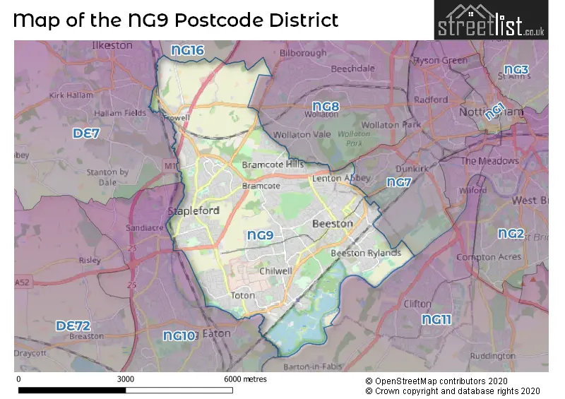
Map of the NG9 Postcode District
Explore the NG9 postcode district by using our free interactive map.
When it comes to local government, postal geography often disregards political borders. However, for a breakdown in the NG9 District: the district mostly encompasses the Broxtowe District (B) (1579 postcodes), and finally, the City of Nottingham (B) area (44 postcodes).
Recent House Sales in NG9
| Date | Price | Address |
|---|---|---|
| 27/10/2023 | £100,000 | Bramcote Lane, Beeston, Nottingham, NG9 4ET |
| 05/10/2023 | £317,000 | Pimlico Avenue, Bramcote, Nottingham, NG9 3JJ |
| 02/10/2023 | £300,000 | Brookhill Street, Stapleford, Nottingham, NG9 7GN |
| 29/09/2023 | £300,000 | Barratt Crescent, Attenborough, Nottingham, NG9 6AH |
| 26/09/2023 | £220,000 | Manville Close, Bramcote, Nottingham, NG9 3GN |
| 26/09/2023 | £292,000 | Seaburn Road, Toton, Nottingham, NG9 6HT |
| 22/09/2023 | £290,000 | Wychwood Drive, Trowell, Nottingham, NG9 3RB |
| 22/09/2023 | £285,000 | Baulk Lane, Stapleford, Nottingham, NG9 8BG |
| 22/09/2023 | £172,000 | Anslow Avenue, Beeston, Nottingham, NG9 2SW |
| 20/09/2023 | £218,000 | Deepdale Avenue, Stapleford, Nottingham, NG9 7FW |
Where is the NG9 Postcode District?
The postcode district NG9 is located in Nottingham. It is nearby the towns of Ilkeston to the North West, Derby to the West, Loughborough to the South, and Sutton-in-Ashfield to the North. Additionally, it is situated approximately 109.15 miles away from the centre of London.
The district is within the post town of NOTTINGHAM.
The sector has postcodes within the nation of England.
The NG9 Postcode District is covers the following regions.
- South Nottinghamshire - Derbyshire and Nottinghamshire - East Midlands (England)
- Nottingham - Derbyshire and Nottinghamshire - East Midlands (England)
Weather Forecast for NG9
Press Button to Show Forecast for Bramcote
| Time Period | Icon | Description | Temperature | Rain Probability | Wind |
|---|---|---|---|---|---|
| 03:00 to 06:00 | Partly cloudy (night) | 13.0°C (feels like 13.0°C) | 0.00% | NE 2 mph | |
| 06:00 to 09:00 | Partly cloudy (day) | 14.0°C (feels like 15.0°C) | 3.00% | E 2 mph | |
| 09:00 to 12:00 | Cloudy | 18.0°C (feels like 18.0°C) | 4.00% | ESE 4 mph | |
| 12:00 to 15:00 | Cloudy | 21.0°C (feels like 21.0°C) | 4.00% | SSE 2 mph | |
| 15:00 to 18:00 | Cloudy | 22.0°C (feels like 22.0°C) | 3.00% | SE 4 mph | |
| 18:00 to 21:00 | Cloudy | 21.0°C (feels like 20.0°C) | 3.00% | SE 7 mph | |
| 21:00 to 00:00 | Partly cloudy (night) | 18.0°C (feels like 17.0°C) | 0.00% | ESE 7 mph |
Press Button to Show Forecast for Bramcote
| Time Period | Icon | Description | Temperature | Rain Probability | Wind |
|---|---|---|---|---|---|
| 00:00 to 03:00 | Partly cloudy (night) | 15.0°C (feels like 15.0°C) | 0.00% | SE 4 mph | |
| 03:00 to 06:00 | Partly cloudy (night) | 13.0°C (feels like 13.0°C) | 0.00% | SE 4 mph | |
| 06:00 to 09:00 | Partly cloudy (day) | 13.0°C (feels like 12.0°C) | 1.00% | ESE 4 mph | |
| 09:00 to 12:00 | Partly cloudy (day) | 17.0°C (feels like 16.0°C) | 0.00% | ESE 7 mph | |
| 12:00 to 15:00 | Partly cloudy (day) | 21.0°C (feels like 19.0°C) | 1.00% | SE 9 mph | |
| 15:00 to 18:00 | Cloudy | 22.0°C (feels like 20.0°C) | 3.00% | SE 9 mph | |
| 18:00 to 21:00 | Cloudy | 21.0°C (feels like 19.0°C) | 3.00% | ESE 9 mph | |
| 21:00 to 00:00 | Cloudy | 17.0°C (feels like 16.0°C) | 4.00% | ESE 9 mph |
Press Button to Show Forecast for Bramcote
| Time Period | Icon | Description | Temperature | Rain Probability | Wind |
|---|---|---|---|---|---|
| 00:00 to 03:00 | Cloudy | 14.0°C (feels like 13.0°C) | 3.00% | ESE 7 mph | |
| 03:00 to 06:00 | Cloudy | 12.0°C (feels like 11.0°C) | 3.00% | E 4 mph | |
| 06:00 to 09:00 | Cloudy | 13.0°C (feels like 12.0°C) | 4.00% | ENE 4 mph | |
| 09:00 to 12:00 | Cloudy | 17.0°C (feels like 16.0°C) | 4.00% | E 7 mph | |
| 12:00 to 15:00 | Cloudy | 21.0°C (feels like 20.0°C) | 7.00% | SE 9 mph | |
| 15:00 to 18:00 | Cloudy | 22.0°C (feels like 20.0°C) | 18.00% | SSE 11 mph | |
| 18:00 to 21:00 | Light rain shower (day) | 20.0°C (feels like 19.0°C) | 40.00% | SSE 9 mph | |
| 21:00 to 00:00 | Cloudy | 17.0°C (feels like 16.0°C) | 16.00% | SSE 7 mph |
Press Button to Show Forecast for Bramcote
| Time Period | Icon | Description | Temperature | Rain Probability | Wind |
|---|---|---|---|---|---|
| 00:00 to 03:00 | Cloudy | 15.0°C (feels like 15.0°C) | 10.00% | S 7 mph | |
| 03:00 to 06:00 | Cloudy | 14.0°C (feels like 13.0°C) | 12.00% | S 7 mph | |
| 06:00 to 09:00 | Overcast | 13.0°C (feels like 12.0°C) | 13.00% | S 9 mph | |
| 09:00 to 12:00 | Overcast | 15.0°C (feels like 14.0°C) | 14.00% | S 9 mph | |
| 12:00 to 15:00 | Cloudy | 17.0°C (feels like 15.0°C) | 18.00% | S 11 mph | |
| 15:00 to 18:00 | Heavy rain | 17.0°C (feels like 15.0°C) | 76.00% | SSE 13 mph | |
| 18:00 to 21:00 | Heavy rain | 15.0°C (feels like 13.0°C) | 78.00% | SSE 11 mph | |
| 21:00 to 00:00 | Heavy rain | 14.0°C (feels like 12.0°C) | 77.00% | SSE 11 mph |
Press Button to Show Forecast for Bramcote
| Time Period | Icon | Description | Temperature | Rain Probability | Wind |
|---|---|---|---|---|---|
| 00:00 to 03:00 | Light rain | 13.0°C (feels like 11.0°C) | 55.00% | SSE 9 mph | |
| 03:00 to 06:00 | Cloudy | 12.0°C (feels like 11.0°C) | 18.00% | SSE 9 mph | |
| 06:00 to 09:00 | Cloudy | 12.0°C (feels like 10.0°C) | 11.00% | SSE 9 mph | |
| 09:00 to 12:00 | Light rain shower (day) | 14.0°C (feels like 12.0°C) | 34.00% | SSE 11 mph | |
| 12:00 to 15:00 | Light rain shower (day) | 16.0°C (feels like 13.0°C) | 35.00% | SSE 13 mph | |
| 15:00 to 18:00 | Light rain shower (day) | 16.0°C (feels like 14.0°C) | 38.00% | S 13 mph | |
| 18:00 to 21:00 | Light rain shower (day) | 15.0°C (feels like 13.0°C) | 35.00% | S 11 mph | |
| 21:00 to 00:00 | Clear night | 13.0°C (feels like 11.0°C) | 10.00% | S 9 mph |
| Postcode Sector | Delivery Office |
|---|---|
| NG9 1 | Beeston Delivery Office |
| NG9 2 | Beeston Delivery Office |
| NG9 3 | Beeston Delivery Office |
| NG9 4 | Beeston Delivery Office |
| NG9 5 | Beeston Delivery Office |
| NG9 6 | Beeston Delivery Office |
| NG9 7 | Beeston Delivery Office |
| NG9 8 | Beeston Delivery Office |
| N | G | 9 | - | X | X | X |
| N | G | 9 | Space | Numeric | Letter | Letter |
Current Monthly Rental Prices
| # Bedrooms | Min Price | Max Price | Avg Price |
|---|---|---|---|
| £325 | £1,040 | £881 | |
| 1 | £365 | £1,040 | £622 |
| 2 | £695 | £1,400 | £1,014 |
| 3 | £725 | £3,800 | £1,686 |
| 4 | £390 | £2,773 | £1,932 |
| 5 | £500 | £3,683 | £2,587 |
| 6 | £559 | £4,420 | £2,768 |
| 7 | £563 | £5,157 | £3,310 |
| 8 | £737 | £6,066 | £4,372 |
Current House Prices
| # Bedrooms | Min Price | Max Price | Avg Price |
|---|---|---|---|
| £1,500,000 | £1,500,000 | £1,500,000 | |
| 1 | £105,000 | £200,000 | £150,619 |
| 2 | £100,000 | £365,000 | £215,346 |
| 3 | £136,000 | £1,000,000 | £302,223 |
| 4 | £185,000 | £1,100,000 | £462,975 |
| 5 | £325,000 | £2,200,000 | £757,541 |
| 6 | £600,000 | £1,700,000 | £1,093,333 |
| 8 | £1,150,000 | £1,150,000 | £1,150,000 |
Estate Agents who Operate in the NG9 District
| Logo | Name | Brand Name | Address | Contact Number | Total Properties |
|---|---|---|---|---|---|
 | Beeston | Robert Ellis | 12 High Road Beeston Nottingham NG9 2JP | 0115 647 2080 | 93 |
 | Beeston | C P Walker & Son | 107 High Road, Beeston, Nottingham, NG9 2JU | 0115 647 1616 | 85 |
 | Stapleford | Robert Ellis | 32 Derby Road Stapleford NG9 7AA | 0115 647 1965 | 70 |
 | Beeston | Bairstow Eves | 105A High Road, Beeston, Nottingham, Nottinghamshire, NG9 2LH | 0115 647 0923 | 39 |
 | Nottingham | Sandstone UK Property Management Solutions Ltd | 6th Floor City Gate East Tollhouse Hill, Nottingham, NG1 5FS | 0115 647 6284 | 34 |
Yearly House Price Averages for the NG9 Postcode District
| Type of Property | 2018 Average | 2018 Sales | 2017 Average | 2017 Sales | 2016 Average | 2016 Sales | 2015 Average | 2015 Sales |
|---|---|---|---|---|---|---|---|---|
| Detached | £289,400 | 360 | £294,685 | 361 | £277,594 | 384 | £269,677 | 400 |
| Semi-Detached | £191,430 | 532 | £180,495 | 532 | £167,900 | 564 | £154,066 | 481 |
| Terraced | £148,015 | 269 | £139,985 | 292 | £174,394 | 328 | £127,007 | 337 |
| Flats | £140,665 | 161 | £119,437 | 103 | £246,714 | 83 | £107,535 | 64 |