The NE36 0 postcode sector is within the county of Tyne & Wear.
Did you know? According to the 2021 Census, the NE36 0 postcode sector is home to a bustling 6,698 residents!
Given that each sector allows for 400 unique postcode combinations. Letters C, I, K, M, O and V are not allowed in the last two letters of a postcode. With 210 postcodes already in use, this leaves 190 units available.
The largest settlements in the NE36 0 postal code are EAST BOLDON and West Boldon.
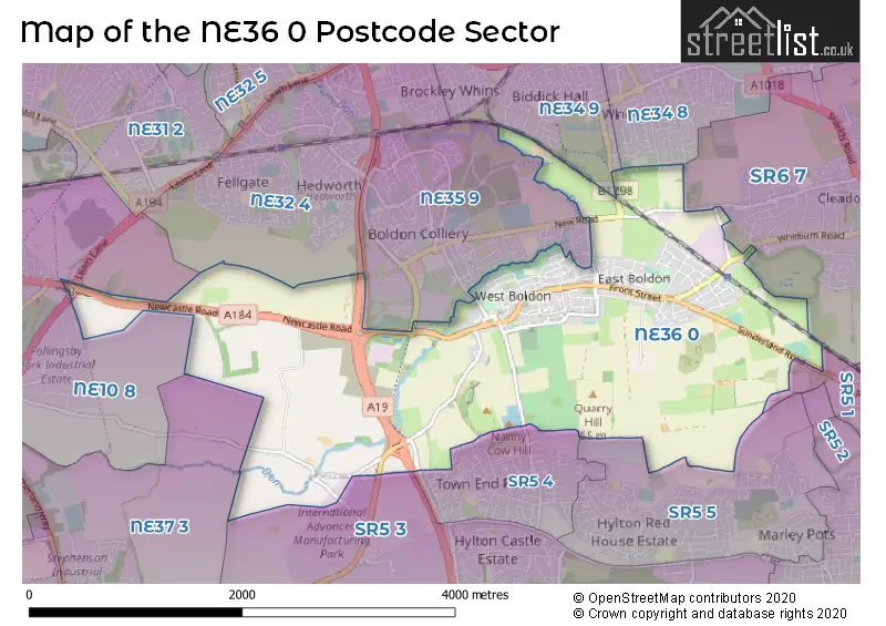
The NE36 0 Postcode shares a border with NE10 8 (GATESHEAD, Wardley), NE32 4 (JARROW), NE34 8 (SOUTH SHIELDS), NE34 9 (SOUTH SHIELDS), NE35 9 (BOLDON COLLIERY, Boldon Business Park), NE37 3 (WASHINGTON), SR5 4 (SUNDERLAND), SR5 5 (SUNDERLAND), SR5 1 (SUNDERLAND), SR5 3 (SUNDERLAND, Castletown, Sunderland Enterprise Park) and SR6 7 (SUNDERLAND, Cleadon, Whitburn).
The sector is within the post town of EAST BOLDON.
NE36 0 is a postcode sector within the NE3 postcode district which is within the NE Newcastle upon Tyne postcode area.
The Royal Mail delivery office for the NE36 0 postal sector is the unknown.
The area of the NE36 0 postcode sector is 4.16 square miles which is 10.76 square kilometres or 2,659.96 square acres.
The NE36 0 postcode sector is crossed by the A19 Major A road.
The NE36 0 postcode sector is crossed by the A194M Major A road.
The NE36 0 postcode sector is crossed by the A184 Major A road.
Waterways within the NE36 0 postcode sector include the Don.

Map of the NE36 0 Postcode Sector
Explore the NE36 0 postcode sector by using our free interactive map.
| N | E | 3 | 6 | - | 0 | X | X |
| N | E | 3 | 6 | Space | 0 | Letter | Letter |
Official List of Streets
West Boldon (53 Streets)
EAST BOLDON (74 Streets)
Unofficial Streets or Alternative Spellings
SUNDERLAND
BLUE HOUSE LANE EAST BOLDON ROADCleadon
BOLDON LANE MOOR LANE WHITBURN ROAD BOLDON LANE DOWNHILL LANE INTERCHANGE FELLING BYPASS GREEN LANE HIGH HOUSE FARM LAVERICK LANE MANSION HOUSE SAINT CHADS VILLAS SAINT GEORGES TERRACE SAINT JOHNS TERRACE SAINT MARYS TERRACE SAINT NICHOLAS ROAD SAINT NICHOLAS VIEW TESTOS ROUNDABOUT WEST HARTON MINERAL LINE WEST PASTURES WHITEMARE POOL ROUNDABOUTBOLDON COLLIERY
ABINGDON WAY BURNS AVENUE NEW ROAD NORTH ROADWest Boldon
HARTON VIEWSOUTH SHIELDS
WHITELEAS WAYSUNDERLAND,
WASHINGTON ROADSchools and Places of Education Within the NE36 0 Postcode Sector
East Boldon Infants' School
Community school
Front Street, East Boldon, Tyne and Wear, NE36 0SW
Head: Miss L Holt
Ofsted Rating: Good
Inspection: 2022-06-08 (715 days ago)
Website: Visit East Boldon Infants' School Website
Phone: 01915367292
Number of Pupils: 178
East Boldon Junior School
Community school
North Lane, Tyne & Wear, Tyne and Wear, NE36 0DL
Head: Mr Timothy Shenton
Ofsted Rating: Good
Inspection: 2022-05-05 (749 days ago)
Website: Visit East Boldon Junior School Website
Phone: 01915362030
Number of Pupils: 234
Helen Gibson Nursery School
Local authority nursery school
North Lane, East Boldon, Tyne and Wear, NE36 0DL
Head: Mrs J Parker
Ofsted Rating: Outstanding
Inspection: 2022-09-27 (604 days ago)
Website: Visit Helen Gibson Nursery School Website
Phone: 01915196846
Number of Pupils: 79
West Boldon Primary School
Community school
Hindmarch Drive, East Boldon, Tyne and Wear, NE36 0HX
Head: Mrs Linsey Garr
Ofsted Rating: Good
Inspection: 2021-09-29 (967 days ago)
Website: Visit West Boldon Primary School Website
Phone: 01915362846
Number of Pupils: 252
House Prices in the NE36 0 Postcode Sector
| Type of Property | 2018 Average | 2018 Sales | 2017 Average | 2017 Sales | 2016 Average | 2016 Sales | 2015 Average | 2015 Sales |
|---|---|---|---|---|---|---|---|---|
| Detached | £421,174 | 17 | £351,157 | 14 | £289,215 | 28 | £291,763 | 15 |
| Semi-Detached | £192,338 | 50 | £179,209 | 53 | £206,486 | 53 | £167,896 | 37 |
| Terraced | £168,245 | 20 | £193,488 | 27 | £170,140 | 43 | £183,486 | 40 |
| Flats | £140,286 | 7 | £98,563 | 16 | £124,245 | 10 | £135,544 | 10 |
Important Postcodes NE36 0 in the Postcode Sector
NE36 0DL is the postcode for East Boldon Junior School, North Road
NE36 0HX is the postcode for West Boldon Junior Mixed School, Hindmarch Drive, and West Boldon Junior Mixed School, Hindmarch Drive, West Boldon
NE36 0QG is the postcode for Boldon C of E Primary School, Don Gardens
NE36 0RY is the postcode for Boker Lane Health Centre, Boker Lane
NE36 0SW is the postcode for East Boldon Infant School, Front Street
| The NE36 0 Sector is within these Local Authorities |
|
|---|---|
| The NE36 0 Sector is within these Counties |
|
| The NE36 0 Sector is within these Water Company Areas |
|