This section of the site is all about the DT Postcode area, also known as the Dorchester Postal Area. Explore links to the next level to learn more about specific postcode districts such as DT1.
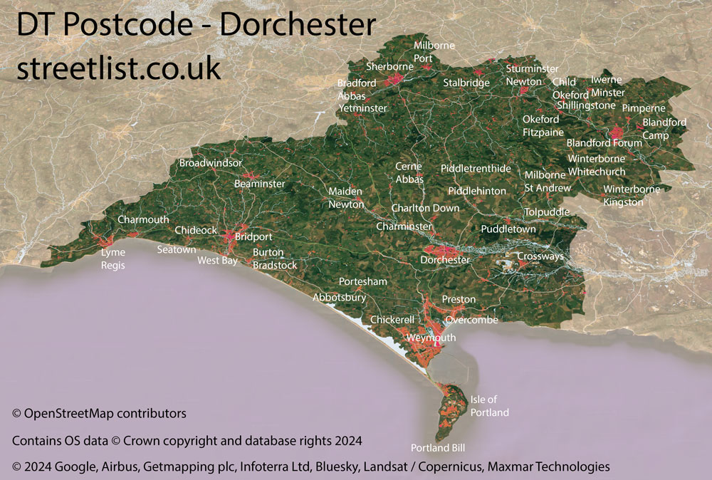
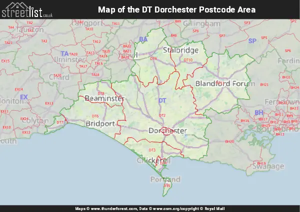
Map of the DT Postcode for Dorchester
Quick Facts about the DT Postcode
| Width from East to West | 44.20 mi |
| Height from North to South | 35.51 mi |
| Area of DT | 645.48 mi² |
| Maximum Width | 46.85 mi |
| Perimeter of Postcode Area | 206.41 mi |
| Number of Postcode Districts | 11 |
| Number of Postcode Sectors | 39 |
| Number of Post Towns | 9 |
| Number of Postcodes | 7,819 |
The DT postcode area represents a group of postal districts in the Dorchester area of the United Kingdom. The area code DT stands for the letters d and t in DorchesTer. DT has a population of 213,203 and covers an area of 1,664,433 hectares. Fun fact: 0.33% of the population of Great Britain lives in this area.
The postcode area falls within the following counties: Dorset (97.17%), Somerset (1.75%), Devon (1.08%).
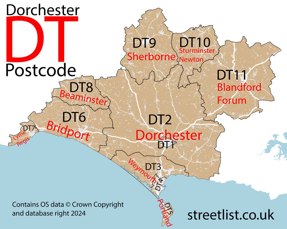
Post Towns and Postcode Districts for the DT Postcode
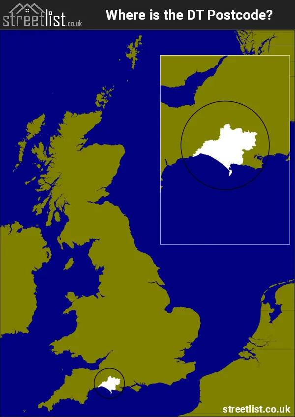
Where is the DT Postcode Area?
The DT Dorchester Postcode is in the South West of England. TheDT postal area borders the following neighbouring postal areas: TA - Taunton, SP - Salisbury, EX - Exeter, BH - Bournemouth and BA - Bath, It also borders The English Channel,
Map of the DT Dorchester Postcode Area
Explore the DT Dorchester postcode area by using our interactive map.
How built up is the DT Postcode?
I've calculated the total area covered by building footprints within the DT postcode area.
By analyzing this against the total area, I've determined the percentage of the area that's developed, this will give you an idea of how urban or rural the DT postcode region is.
The higher the percentage the more urban the area is. For example the least urban district is DT2 and the most urban is DT1.
| Postcode District | Total Area (m²) | Footprint Area (m²) | Built Percentage % |
|---|---|---|---|
| DT2 | 607,583,187 | 3,217,166 | 0.53% |
| DT11 | 331,864,659 | 2,528,651 | 0.76% |
| DT8 | 82,687,249 | 674,026 | 0.82% |
| DT9 | 194,968,558 | 1,984,279 | 1.02% |
| DT6 | 174,688,596 | 1,967,541 | 1.13% |
| DT10 | 116,433,771 | 1,316,445 | 1.13% |
| DT3 | 93,469,377 | 1,505,127 | 1.61% |
| DT7 | 24,678,221 | 441,660 | 1.79% |
| DT5 | 11,177,854 | 657,742 | 5.88% |
| DT4 | 14,283,864 | 1,666,935 | 11.67% |
| DT1 | 7,543,197 | 1,053,890 | 13.97% |
| DT Total | 1,659,378,533 (m²) | 17,013,462 (m²) | 1.03% |
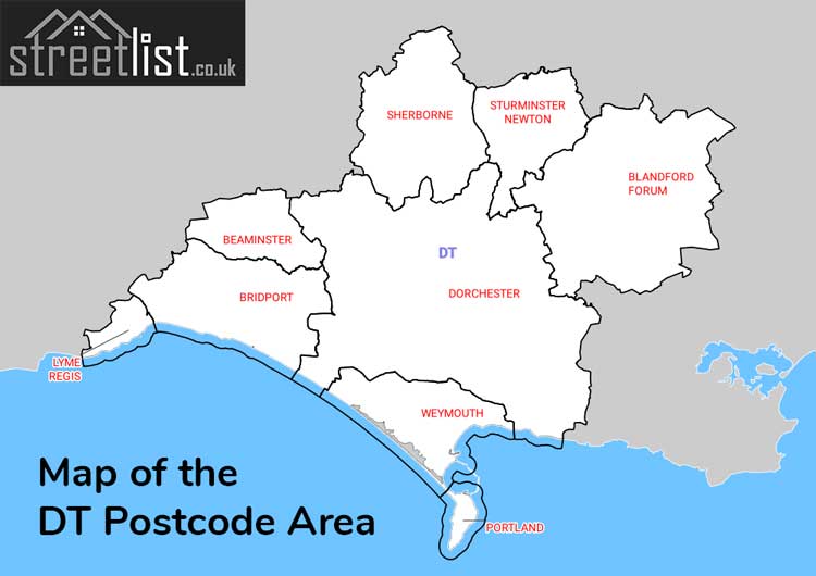
Postcode Districts within the DT Dorchester Postcode Area
There are 11 postcode districts within the Dorchester postcode area
A map showing the boundary of DT in relation to other areas
There are 11 towns within the Dorchester postcode area.
| Unit | Area² |
|---|---|
| Hectares | 1,664,433² |
| Miles | 6,426² |
| Feet | 179,157,903,687² |
| Kilometres | 16,644² |
Postal Delivery Offices serving the DT Dorchester Postcode Area
- Blandford Forum Delivery Office
- Bridport Delivery Office
- Dorchester Delivery Office
- Lyme Regis Scale Payment Delivery Office
- Portland Delivery Office
- Sherborne Delivery Office
- Sturminster Newton Delivery Office
- Weymouth Delivery Office
Councils with Postcodes in DT
Towns and Villages within the DT Dorchester Postcode Area
- Abbotsbury - village
- Alton Pancras - village
- Alweston - village
- Anderson - village
- Ansty - village
- Askerswell - village
- Beaminster - town
- Beer Hackett - village
- Bishop's Caundle - village
- Blacknoll - village
- Blandford Forum - town
- Bradford Abbas - village
- Bradpole - village
- Briantspuddle - village
- Bridport - town
- Broad Oak - village
- Broadmayne - village
- Broadwindsor - village
- Bryanston - village
- Buckland Newton - village
- Buckland Ripers - village
- Burton Bradstock - village
- Cattistock - village
- Cerne Abbas - village
- Charlton Down - village
- Charlton Horethorne - village
- Charlton Marshall - village
- Charminster - village
- Charmouth - village
- Cheselbourne - village
- Chetnole - village
- Chickerell - town
- Chideock - village
- Child Okeford - village
- Corscombe - village
- Corton Denham - village
- Crossways - village
- Dewlish - village
- Dorchester - town
- Drimpton - village
- Durweston - village
- East Knighton - village
- Easton - village
- Evershot - village
- Fleet - otherSettlement
- Fortuneswell - town
- Frampton - village
- Gibbs Marsh - otherSettlement
- Glanvilles Wootton - village
- Godmanstone - village
- Grove - village
- Hazelbury Bryan - village
- Higher Ansty - village
- Hilton - village
- Hinton St Mary - village
- Holwell - village
- Hooke - village
- Iwerne Minster - village
- King's Stag - village
- Langton Herring - village
- Leigh - village
- Litton Cheney - village
- Loders - village
- Long Bredy - village
- Longburton - village
- Lower Eype - village
- Lydlinch - village
- Lyme Regis - town
- Maiden Newton - village
- Manston - village
- Mappowder - village
- Marnhull - village
- Marshalsea - village
- Melbury Osmond - village
- Melplash - village
- Middlemarsh - otherSettlement
- Milborne Port - village
- Milborne St Andrew - village
- Milton Abbas - village
- Morcombelake - village
- Moreton - village
- Mosterton - village
- Nether Compton - village
- Netherbury - village
- Nettlecombe - village
- Oborne - village
- Okeford Fitzpaine - village
- Osmington - village
- Osmington Mills - village
- Over Compton - village
- Owermoigne - village
- Piddlehinton - village
- Piddletrenthide - village
- Pimperne - village
- Plush - village
- Portesham - village
- Powerstock - village
- Poyntington - village
- Puddletown - village
- Pulham - village
- Puncknowle - village
- Purse Caundle - village
- Pymore - village
- Rampisham - village
- Ryall - village
- Salway Ash - village
- Sandford Orcas - village
- Shapwick - village
- Sherborne - town
- Shillingstone - village
- Shipton Gorge - village
- Shroton / Iwerne Courtney - village
- South Perrott - village
- Southwell - village
- Spetisbury - village
- Stalbridge - town
- Stinsford - village
- Stoke Abbott - village
- Stourpaine - village
- Stourton Caundle - village
- Stratton - village
- Sturminster Newton - town
- Sutton Waldron - village
- Swyre - village
- Sydling St Nicholas - village
- Symondsbury - village
- Tarrant Gunville - village
- Tarrant Hinton - village
- Tarrant Keyneston - village
- Tarrant Monkton - village
- Tarrant Rushton - village
- Thornford - village
- Todber - village
- Toller Porcorum - village
- Tollerford - village
- Tolpuddle - village
- Trent - village
- Uploders - village
- Uplyme - village
- Walditch - village
- Warmwell - village
- West Bexington - village
- West Knighton - village
- West Milton - village
- West Stafford - village
- Weston - village
- Weymouth - town
- Whitchurch Canonicorum - village
- White Lackington - village
- Winfrith Newburgh - village
- Winterborne Kingston - village
- Winterborne St Martin / Martinstown - village
- Winterborne Stickland - village
- Winterborne Whitechurch - village
- Winterborne Zelston - village
- Winterbourne Abbas - village
- Woolford's Water - village
- Woolland - village
- Wootton Fitzpaine - village
- Wraxall - otherSettlement
- Yawl - village
- Yetminster - village