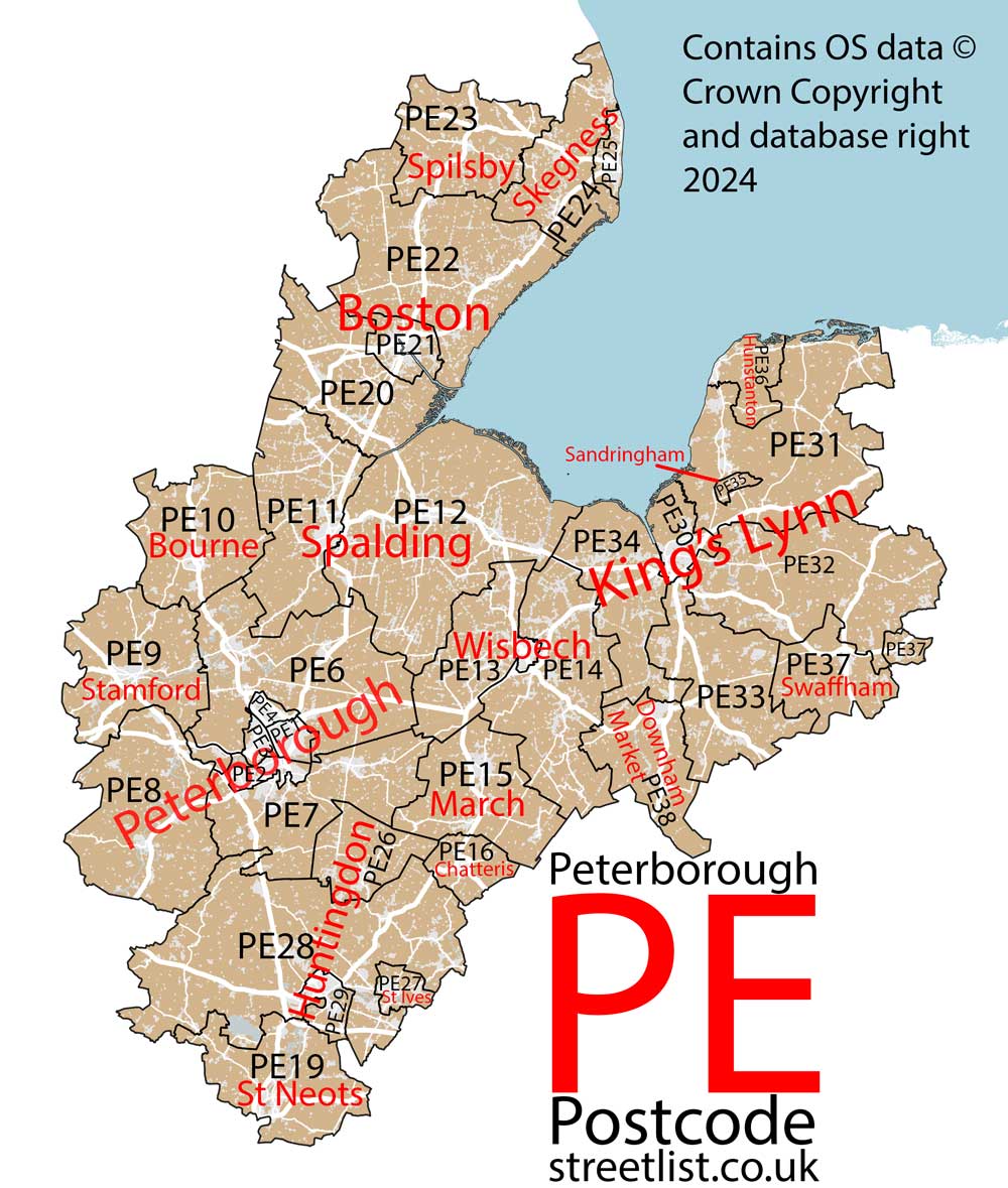
This section of the site is all about the PE Postcode area, also known as the Peterborough Postal Area. Explore links to the next level to learn more about specific postcode districts such as PE1.
The PE postcode area represents a group of postal districts in the Peterborough area of the United Kingdom. The area code PE stands for the letters p and e in PEterborough. PE has a population of 890,223 and covers an area of 5,683,985 hectares. Fun fact: 1.37% of the population of Great Britain lives in this area.
The postcode area falls within the following counties: Cambridgeshire (47.37%), Lincolnshire (30.80%), Norfolk (19.10%), Northamptonshire (1.92%), Rutland (0.63%), Bedfordshire (0.19%).
Post Towns and Postcode Districts for the PE Postcode
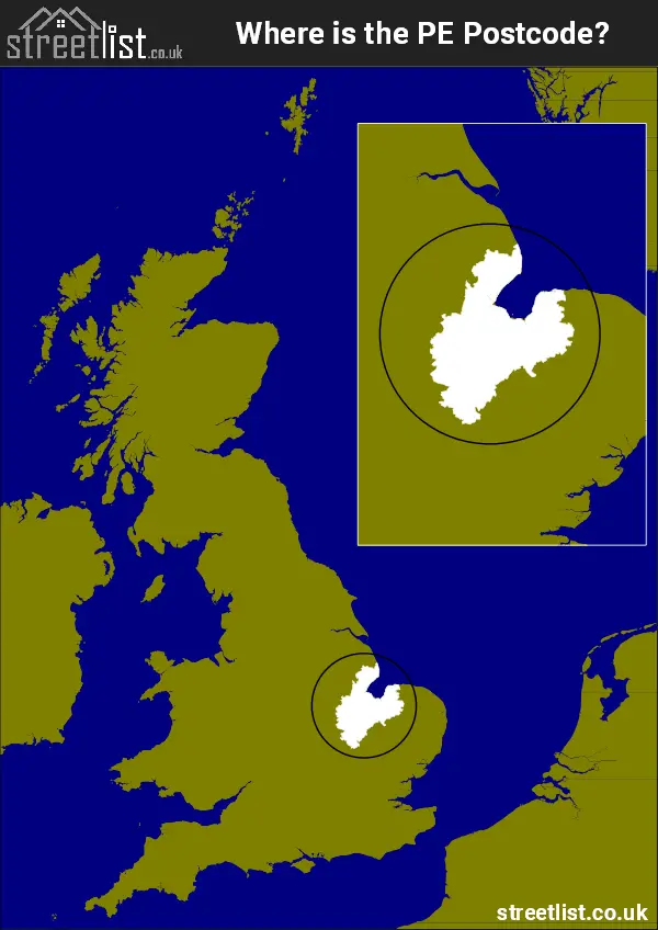
Where is the PE Postcode Area?
The PE Peterborough Postcode has it's North is in the East Midlands and it's South is in East of England. ThePE postal area borders the following neighbouring postal areas: LN - Lincoln, LE - Leicester, CB - Cambridge, SG - Stevenage, NR - Norwich, NN - Northampton, NG - Nottingham, IP - Ipswich and MK - Milton Keynes, It also borders The North Sea and The Wash.
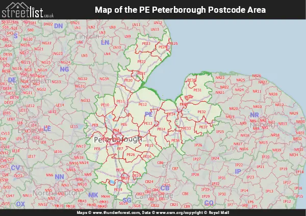
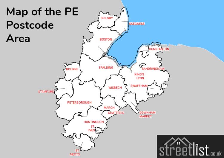
Map of the PE Peterborough Postcode Area
Explore the PE Peterborough postcode area by using our interactive map.
How built up is the PE Postcode?
I've calculated the total area covered by building footprints within the PE postcode area.
By analyzing this against the total area, I've determined the percentage of the area that's developed, this will give you an idea of how urban or rural the PE postcode region is.
The higher the percentage the more urban the area is. For example the least urban district is PE35 and the most urban is PE1.
| Postcode District | Total Area (m²) | Footprint Area (m²) | Built Percentage % |
|---|---|---|---|
| PE35 | 8,449,646 | 30,493 | 0.36% |
| PE32 | 313,786,584 | 1,727,712 | 0.55% |
| PE31 | 339,002,735 | 1,961,854 | 0.58% |
| PE22 | 352,997,889 | 2,244,373 | 0.64% |
| PE8 | 265,695,513 | 1,735,818 | 0.65% |
| PE23 | 168,469,685 | 1,152,191 | 0.68% |
| PE20 | 198,430,493 | 1,469,887 | 0.74% |
| PE33 | 203,765,205 | 1,636,669 | 0.80% |
| PE24 | 156,630,359 | 1,265,168 | 0.81% |
| PE37 | 120,401,675 | 989,928 | 0.82% |
| PE34 | 168,343,637 | 1,385,674 | 0.82% |
| PE6 | 309,177,643 | 2,693,694 | 0.87% |
| PE28 | 501,548,481 | 4,359,453 | 0.87% |
| PE38 | 130,632,576 | 1,173,712 | 0.90% |
| PE14 | 251,416,590 | 2,375,309 | 0.94% |
| PE26 | 89,164,895 | 848,361 | 0.95% |
| PE12 | 441,364,501 | 4,344,710 | 0.98% |
| PE10 | 175,754,375 | 1,823,439 | 1.04% |
| PE5 | 10,314,547 | 108,472 | 1.05% |
| PE9 | 199,255,519 | 2,220,993 | 1.11% |
| PE36 | 55,207,746 | 655,006 | 1.19% |
| PE15 | 173,816,628 | 2,358,551 | 1.36% |
| PE16 | 50,677,080 | 723,730 | 1.43% |
| PE11 | 223,784,459 | 3,362,402 | 1.50% |
| PE19 | 177,900,526 | 2,675,190 | 1.50% |
| PE7 | 208,175,639 | 3,357,571 | 1.61% |
| PE13 | 147,259,522 | 2,792,187 | 1.90% |
| PE27 | 25,087,236 | 1,129,549 | 4.50% |
| PE30 | 50,437,218 | 2,694,060 | 5.34% |
| PE29 | 29,366,462 | 1,749,402 | 5.96% |
| PE21 | 44,917,537 | 2,755,189 | 6.13% |
| PE25 | 22,941,613 | 1,457,833 | 6.35% |
| PE4 | 11,287,954 | 1,212,651 | 10.74% |
| PE3 | 13,350,661 | 1,517,651 | 11.37% |
| PE2 | 23,415,138 | 2,797,282 | 11.95% |
| PE1 | 19,072,725 | 2,657,531 | 13.93% |
| PE Total | 5,681,300,692 (m²) | 69,443,695 (m²) | 1.22% |
Postcode Districts within the PE Peterborough Postcode Area
There are 36 postcode districts within the Peterborough postcode area
A map showing the boundary of PE in relation to other areas
There are 25 towns within the Peterborough postcode area.
| Unit | Area² |
|---|---|
| Hectares | 5,683,985² |
| Miles | 21,946² |
| Feet | 611,818,461,415² |
| Kilometres | 56,840² |
Postal Delivery Offices serving the PE Peterborough Postcode Area
- Ailsworth Scale Payment Delivery Office
- Bircham Scale Payment Delivery Office
- Bluntisham Scale Payment Delivery Office
- Boston Delivery Office
- Bourne Delivery Office
- Brancaster Scale Payment Delivery Office
- Burnham Market Scale Payment Delivery Office
- Chatteris Delivery Office
- Clenchwarton Scale Payment Delivery Office
- Delivery Office Cking Scale Payment Delivery Office
- Dersingham Scale Payment Delivery Office
- Downham Market Delivery Office
- East Rudham Scale Payment Delivery Office
- East Winch Scale Payment Delivery Office
- Easton On The Hill Scale Payment Delivery Office
- Elton Scale Payment Delivery Office
- Eye Scale Payment Delivery Office
- Farcet Scale Payment Delivery Office
- Fenstanton Scale Payment Delivery Office
- Gayton Scale Payment Delivery Office
- Glinton Scale Payment Delivery Office
- Grimston Scale Payment Delivery Office
- Heacham Scale Payment Delivery Office
- Holbeach Delivery Office
- Holme Scale Payment Delivery Office
- Hunstanton Delivery Office
- Huntingdon Delivery Office
- Ketton Scale Payment Delivery Office
- Kimbolton Scale Payment Delivery Office
- Kings Cliffe Scale Payment Delivery Office
- Kings Lynn Delivery Office
- Litcham Scale Payment Delivery Office
- Long Sutton Scale Payment Delivery Office
- Magdalen Scale Payment Delivery Office
- March Delivery Office
- Market Deeping Delivery Office
- Middleton (pe32) Scale Payment Delivery Office
- Narborough Scale Payment Delivery Office
- Newborough Scale Payment Delivery Office
- Oundle Delivery Office
- Outwell Scale Payment Delivery Office
- Peterborough Postal Delivery Office
- Peterborough South Postal Delivery Office
- Raf Marham Scale Payment Delivery Office
- Ramsey Delivery Office (pe)
- Ryhall Scale Payment Delivery Office
- Sawtry Scale Payment Delivery Office
- Skegness Delivery Office
- Snettisham Scale Payment Delivery Office
- Somersham Scale Payment Delivery Office
- Spalding Delivery Office
- Spilsby Delivery Office
- St. Germans Scale Payment Delivery Office
- St. Ives (pe) Delivery Office
- St. Neots Delivery Office
- Stamford Delivery Office
- Stilton Scale Payment Delivery Office
- Stoke Ferry Scale Payment Delivery Office
- Stow Bridge Scale Payment Delivery Office
- Sutton Bridge Scale Payment Delivery Office
- Swaffham Delivery Office
- Terrington St.clement Scale Payment Delivery Office
- Upwell Scale Payment Delivery Office
- Wansford Scale Payment Delivery Office
- Warboys Scale Payment Delivery Office
- Watlington (pe) Scale Payment Delivery Office
- Welney Scale Payment Delivery Office
- Wereham Scale Payment Delivery Office
- West Lynn Scale Payment Delivery Office
- West Winch Scale Payment Delivery Office
- Wisbech Delivery Office
- Wittering Scale Payment Delivery Office
Councils with Postcodes in PE
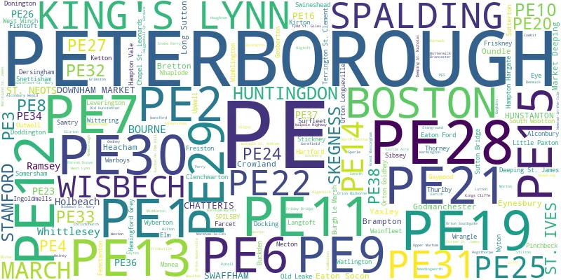
Towns and Villages within the PE Peterborough Postcode Area
- Abbots Ripton - village
- Abbotsley - village
- Ailsworth - village
- Alconbury - village
- Alconbury Weston - village
- Algarkirk - village
- Anderby - village
- Anderby Creek - village
- Anton's Gowt - village
- Apethorpe - village
- Ashby by Partney - village
- Ashwicken - village
- Aswardby - otherSettlement
- Bainton - village
- Barholm - village
- Barnack - village
- Barnwell - village
- Barroway Drove - village
- Barton Bendish - village
- Baston - village
- Beachamwell - village
- Beeston - village
- Belmesthorpe - village
- Benington - village
- Benwick - village
- Bicker - village
- Bicker Gauntlet - otherSettlement
- Blackborough End - village
- Bluntisham - village
- Boston - town
- Boughton - village
- Bourne - town
- Braceborough - village
- Brampton - village
- Brancaster - village
- Brancaster Staithe - village
- Bratoft - village
- Brington - village
- Broughton - village
- Buckden - village
- Buckworth - village
- Burgh le Marsh - village
- Burnham Deepdale - village
- Burnham Market - village
- Burnham Norton - village
- Burnham Overy Staithe - village
- Burnham Overy Town - village
- Burnham Thorpe - village
- Bury - village
- Butterwick - village
- Bythorn - village
- Candlesby - village
- Carlby - village
- Carrington - otherSettlement
- Castle Acre - village
- Castle Rising - village
- Castor - village
- Catworth - village
- Chapel St Leonards - village
- Chatteris - town
- Chesterton - village
- Christchurch - village
- Clenchwarton - village
- Coates - village
- Cockley Cley - village
- Coldham - village
- Collyweston - village
- Colne - village
- Congham - village
- Coningsby - village
- Conington - village
- Covington - village
- Cowbit - village
- Crimplesham - village
- Croft - village
- Crowland - town
- Croxton - village
- Dalby - otherSettlement
- Deeping Gate - village
- Deeping St James - village
- Deeping St Nicholas - village
- Denver - village
- Dersingham - village
- Docking - village
- Doddington - village
- Donington - village
- Downham Market - town
- Dowsby - village
- Dowsdale - village
- Drayton - village
- Duddington - village
- Dunsby - village
- Dyke - village
- Earith - village
- East Heckington - village
- East Keal - village
- East Kirkby - village
- East Perry - village
- East Rudham - village
- East Walton - otherSettlement
- East Winch - village
- Easton - village
- Easton on the Hill - village
- Eastrea - village
- Eastville - village
- Edenham - village
- Ellington - village
- Elm - village
- Eltisley - village
- Elton - village
- Emneth - village
- Essendine - village
- Etton - village
- Eye - village
- Eye Green - village
- Farcet - village
- Fenstanton - village
- Fincham - village
- Firsby - village
- Fishtoft - village
- Fishtoft Drove - village
- Fleet - village
- Fleet Hargate - village
- Flitcham - village
- Fold Hill - village
- Folksworth - village
- Fosdyke - village
- Frampton - village
- Frampton - village
- Frampton West End - village
- Freiston - village
- Friday Bridge - village
- Fring - village
- Friskney - village
- Friskney Eaudyke - village
- Friskney Tofts - village
- Frithville - village
- Frognall - village
- Gayton - village
- Gedney - village
- Gedney Broadgate - otherSettlement
- Gedney Drove End - village
- Gedney Dyke - village
- Gedney Hill - village
- Gibraltar - otherSettlement
- Gipsey Bridge - village
- Glapthorn - village
- Glatton - village
- Glinton - village
- Godmanchester - town
- Gooderstone - village
- Gorefield - village
- Gosberton - village
- Gosberton Cheal - otherSettlement
- Grafham - village
- Graveley - village
- Great Bircham - village
- Great Casterton - village
- Great Dunham - village
- Great Gidding - village
- Great Massingham - village
- Great Paxton - village
- Great Staughton - village
- Great Steeping - village
- Great Stukeley - village
- Greatford - village
- Grimsthorpe - village
- Grimston - village
- Guyhirn - village
- Haconby - village
- Hagworthingham - village
- Hail Weston - village
- Haltoft End - village
- Halton Fenside - village
- Halton Holegate - village
- Hamerton - village
- Hanthorpe - village
- Haroldsbridge - otherSettlement
- Harpley - village
- Heacham - village
- Helpston - village
- Hemingford Abbots - village
- Hemingford Grey - village
- Hilgay - village
- Hilldyke - otherSettlement
- Hillington - village
- Hilton - village
- Hoffleet Stow - otherSettlement
- Hogsthorpe - village
- Holbeach - town
- Holbeach Bank - village
- Holbeach Clough - village
- Holbeach Drove - village
- Holbeach Hurn - village
- Holbeach St Johns - village
- Holbeach St Marks - village
- Holbeach St Matthew - otherSettlement
- Holme - village
- Holme next the Sea - village
- Holywell - village
- Hop Pole - village
- Houghton - village
- Hubbert's Bridge - village
- Hunstanton - town
- Huntingdon - town
- Ingoldisthorpe - village
- Ingoldmells - village
- Irby in the Marsh - village
- Keal Cotes - village
- Ketton - village
- Keyston - village
- Kimbolton - village
- King's Cliffe - village
- King's Dyke - village
- King's Lynn - town
- Kings Ripton - village
- Kirkby Underwood - village
- Kirton - village
- Kirton End - village
- Kirton Holme - village
- Lakes End - village
- Langrick - village
- Langtoft - village
- Leake Commonside - village
- Leighton Bromswold - village
- Leverington - village
- Leverton - village
- Leziate - village
- Litcham - village
- Little Dunham - village
- Little Massingham - village
- Little Paxton - village
- Little Steeping - village
- Little Stukeley - village
- Long Sutton - town
- Low Fulney - village
- Lutton - village
- Lutton - village
- March - town
- Mareham le Fen - village
- Marham - village
- Marholm - village
- Market Deeping - town
- Marshland St James - village
- Mavis Enderby - otherSettlement
- Maxey - village
- Middleton - village
- Mileham - village
- Milking Nook - village
- Molesworth - village
- Morton - village
- Moulton - village
- Moulton Chapel - village
- Moulton Eaugate - otherSettlement
- Moulton Seas End - village
- Murrow - village
- Narborough - village
- Nassington - village
- Necton - village
- Needingworth - village
- New Bolingbroke - village
- Newborough - village
- Newton-in-the-Isle - village
- Nordelph - village
- Norman Cross - village
- North Pickenham - village
- North Runcton - village
- Northborough - village
- Northgate - village
- Northlands - village
- Northorpe - village
- Northorpe - village
- Offord Cluny - village
- Offord D'Arcy - village
- Old Bolingbroke - village
- Old Hunstanton - village
- Old Hurst - village
- Old Leake - village
- Old Weston - village
- Orby - village
- Oundle - town
- Outwell - village
- Oxborough - village
- Parson Drove - village
- Partney - village
- Peakirk - village
- Pentney - village
- Peterborough - city
- Pidley - village
- Pilsgate - village
- Pinchbeck - village
- Pinchbeck West - village
- Pode Hole - village
- Polebrook - village
- Pondersbridge - village
- Pott Row - village
- Quadring - village
- Quadring Eaudike - otherSettlement
- Raithby by Spilsby - village
- Ramsey - town
- Ramsey Forty Foot - village
- Ramsey Heights - village
- Ramsey Mereside - village
- Ramsey St Mary's - village
- Revesby - village
- Ring's End - village
- Ringstead - village
- Rippingale - village
- Risegate - village
- Rougham - village
- Roydon - village
- Runcton Holme - village
- Ryhall - village
- Salters Lode - village
- Sandringham - village
- Saracen's Head - village
- Sausthorpe - village
- Sawtry - village
- Sedgeford - village
- Setchey - village
- Shepeau Stow - village
- Shepherd's Port - village
- Shepherds' Gate - otherSettlement
- Shouldham - village
- Shouldham Thorpe - village
- Sibsey - village
- Sibsey Fen Side - village
- Skegness - town
- Skendleby - village
- Snettisham - village
- Somersham - village
- South Pickenham - village
- Southery - village
- Southoe - village
- Spalding - town
- Spaldwick - village
- Spilsby - town
- Sporle - village
- St Ives - town
- St John's Fen End - village
- St Neots - town
- Stamford - town
- Stanhoe - village
- Stibbington - village
- Stickford - village
- Stickney - village
- Stilton - village
- Stoke Doyle - village
- Stoke Ferry - village
- Stonely - village
- Stow Bardolph - village
- Stow Bridge - village
- Stow Longa - village
- Surfleet - village
- Surfleet Seas End - village
- Sutterton - village
- Sutterton Dowdyke - village
- Sutton - village
- Sutton Bridge - village
- Sutton St Edmund - village
- Sutton St James - village
- Swaffham - town
- Swineshead - village
- Swineshead Bridge - village
- Syderstone - village
- Tallington - village
- Tansor - village
- Ten Mile Bank - village
- Terrington St Clement - otherSettlement
- Terrington St John - village
- Tholomas Drove - village
- Thorney - village
- Thornham - village
- Thornhaugh - village
- Thorpe Fendykes - otherSettlement
- Thorpe St Peter - village
- Three Holes - village
- Throckenholt - village
- Thurlby - village
- Thurning - village
- Tilbrook - village
- Tilney All Saints - village
- Tilney cum Islington - village
- Tilney High End - village
- Tilney St Lawrence - village
- Tinwell - village
- Tipps End - village
- Titchwell - village
- Tittleshall - village
- Toft - village
- Tongue End - village
- Tottenhill - village
- Toynton All Saints - village
- Toynton St Peter - village
- Tumby Woodside - village
- Turves - village
- Tydd Gote - village
- Tydd St Giles - village
- Tydd St Mary - village
- Uffington - village
- Ufford - village
- Upper Benefield - village
- Upper Dean - village
- Upton - village
- Upwell - village
- Upwood - village
- Wadenhoe - village
- Wainfleet All Saints - town
- Wainfleet Bank - village
- Wainfleet St Mary - village
- Walpole Cross Keys - village
- Walpole Highway - village
- Walpole Marsh - village
- Walpole St Andrew - village
- Walpole St Peter - village
- Walton Highway - village
- Wansford - village
- Warboys - village
- Warmington - village
- Weasenham St Peter - village
- Welney - village
- Welton le Marsh - village
- Wereham - village
- West Acre - village
- West Deeping - village
- West Dereham - village
- West End - otherSettlement
- West Keal - village
- West Newton - village
- West Perry - village
- West Rudham - village
- West Walton - village
- West Winch - village
- Weston - village
- Weston Hills - village
- Whaplode - village
- Whaplode Drove - village
- Whaplode St Catherine - village
- Whittington - village
- Whittlesey - town
- Wiggenhall St Germans - village
- Wiggenhall St Mary Magdalen - village
- Wiggenhall St Mary the Virgin - village
- Wigtoft - village
- Wimblington - village
- Wimbotsham - village
- Winwick - village
- Wisbech - town
- Wisbech St Mary - village
- Wistow - village
- Witham on the Hill - village
- Wittering - village
- Wolferton - village
- Wood Enderby - village
- Wood Walton - village
- Woodhurst - village
- Woodnewton - village
- Wormegay - village
- Wothorpe - village
- Wrangle - village
- Wrangle Bank - village
- Wrangle Lowgate - otherSettlement
- Wretton - village
- Wyton - village
- Yarwell - village
- Yaxley - village
- Yelling - village