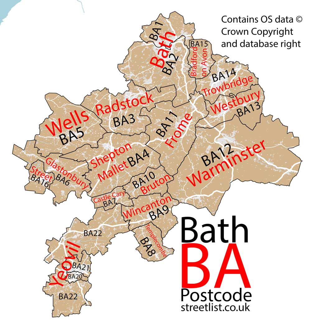
This section of the site is all about the BA Postcode area, also known as the Bath Postal Area. Explore links to the next level to learn more about specific postcode districts such as BA1.
The BA postcode area represents a group of postal districts in the Bath area of the United Kingdom. The area code BA stands for the letters b and a in BAth. BA has a population of 434,166 and covers an area of 1,858,478 hectares. Fun fact: 0.67% of the population of Great Britain lives in this area.
The postcode area falls within the following counties: Somerset (76.41%), Wiltshire (23.26%), Dorset (0.25%), Gloucestershire (0.07%).
Post Towns and Postcode Districts for the BA Postcode
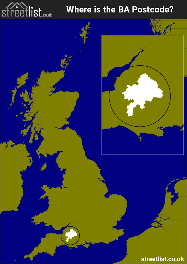
Where is the BA Postcode Area?
The BA Bath Postcode is in the South West England. TheBA postal area borders the following neighbouring postal areas: TA - Taunton, SN - Swindon, SP - Salisbury, DT - Dorchester and BS - Bristol, and is located inland.
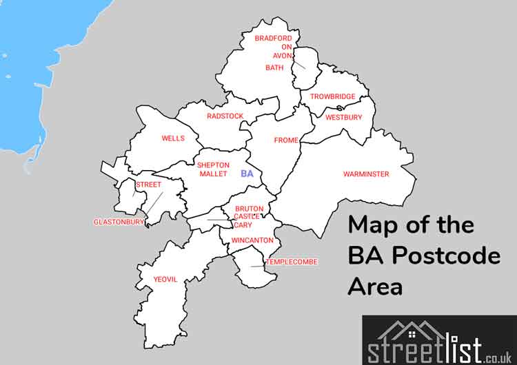
Map of the BA Bath Postcode Area
Explore the BA Bath postcode area by using our interactive map.
How built up is the BA Postcode?
I've calculated the total area covered by building footprints within the BA postcode area.
By analyzing this against the total area, I've determined the percentage of the area that's developed, this will give you an idea of how urban or rural the BA postcode region is.
The higher the percentage the more urban the area is. For example the least urban district is BA12 and the most urban is BA20.
| Postcode District | Total Area (m²) | Footprint Area (m²) | Built Percentage % |
|---|---|---|---|
| BA12 | 363,310,871 | 2,582,042 | 0.71% |
| BA10 | 46,535,120 | 406,228 | 0.87% |
| BA9 | 73,909,035 | 802,219 | 1.09% |
| BA22 | 184,189,918 | 2,049,904 | 1.11% |
| BA8 | 44,073,329 | 496,699 | 1.13% |
| BA4 | 161,043,240 | 1,927,814 | 1.20% |
| BA5 | 132,096,515 | 1,587,362 | 1.20% |
| BA6 | 92,576,801 | 1,183,014 | 1.28% |
| BA7 | 26,386,839 | 374,300 | 1.42% |
| BA11 | 141,904,277 | 2,307,923 | 1.63% |
| BA13 | 81,658,267 | 1,409,088 | 1.73% |
| BA3 | 129,274,631 | 2,392,012 | 1.85% |
| BA15 | 38,873,152 | 818,555 | 2.11% |
| BA2 | 147,351,094 | 3,592,763 | 2.44% |
| BA16 | 28,501,200 | 800,648 | 2.81% |
| BA14 | 80,823,364 | 2,754,911 | 3.41% |
| BA1 | 57,329,217 | 1,965,659 | 3.43% |
| BA21 | 20,508,507 | 1,403,340 | 6.84% |
| BA20 | 8,125,807 | 937,622 | 11.54% |
| BA Total | 1,858,471,184 (m²) | 29,792,103 (m²) | 1.6% |
Postcode Districts within the BA Bath Postcode Area
There are 19 postcode districts within the Bath postcode area

A map showing the boundary of BA in relation to other areas
There are 15 towns within the Bath postcode area.
| Unit | Area² |
|---|---|
| Hectares | 1,858,478² |
| Miles | 7,176² |
| Feet | 200,044,713,442² |
| Kilometres | 18,585² |
Postal Delivery Offices serving the BA Bath Postcode Area
- Bath Delivery Office
- Bradford-on-avon Delivery Office
- Bruton Scale Payment Delivery Office
- Castle Cary Scale Payment Delivery Office
- Freshford Scale Payment Delivery Office
- Frome Delivery Office
- Glastonbury Delivery Office
- Hinton Charterhouse Scale Payment Delivery Office
- Limpley Stoke Scale Payment Delivery Office
- Mere Scale Payment Delivery Office
- Radstock Delivery Office
- Shepton Mallet Delivery Office
- Trowbridge Delivery Office
- Warminster Delivery Office
- Wells Delivery Office
- Westbury Delivery Office
- Wincanton Delivery Office
- Yeovil Delivery Office
Councils with Postcodes in BA
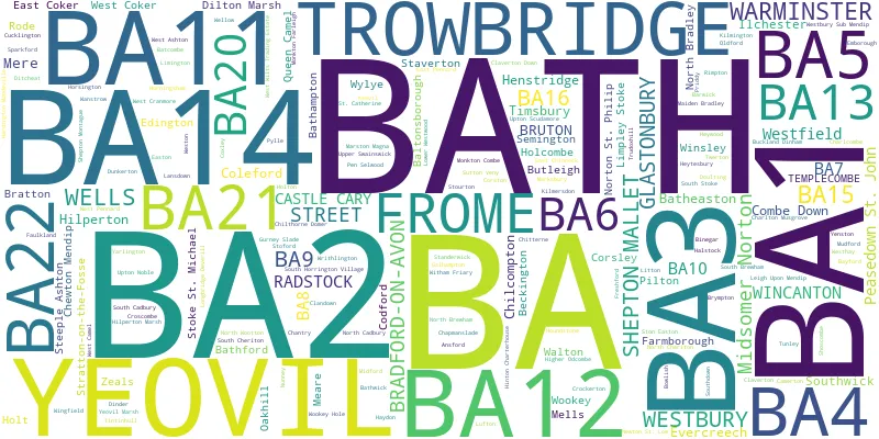
Towns and Villages within the BA Bath Postcode Area
- Abbas Combe - village
- Alford - village
- Alhampton - village
- Ashton Common - village
- Baltonsborough - village
- Barwick - village
- Batcombe - village
- Bath - city
- Bathampton - village
- Batheaston - village
- Bathford - village
- Beckington - village
- Binegar - village
- Blackford - village
- Bourton - village
- Bradford Leigh - village
- Bradford-on-Avon - town
- Bratton - village
- Bruton - town
- Buckland Dinham - village
- Burton - village
- Butleigh - village
- Camerton - village
- Cannard's Grave - village
- Carlingcott - village
- Castle Cary - town
- Chantry - village
- Chapmanslade - village
- Charlton Musgrove - village
- Chewton Mendip - village
- Chilcompton - village
- Chilthorne Domer - village
- Chitterne - village
- Church Row - village
- Clapton - village
- Claverton - village
- Codford St Peter - village
- Coleford - village
- Combe Hay - village
- Compton Pauncefoot - village
- Corsley Heath - village
- Corston - village
- Coulston - village
- Coxley - village
- Coxley Wick - village
- Cranmore - village
- Crockerton - village
- Croscombe - village
- Cucklington - village
- Deptford - village
- Dilton Marsh - village
- Dinder - village
- Ditcheat - village
- Doulting - village
- Downside - village
- Dulcote - village
- Dunkerton - village
- East Chinnock - village
- East Coker - village
- East Horrington - village
- Easton - village
- Edgarley - otherSettlement
- Edington - village
- Englishcombe - village
- Evercreech - village
- Farleigh Hungerford - otherSettlement
- Farmborough - village
- Faulkland - village
- Freshford - village
- Frome - town
- Galhampton - village
- Glastonbury - town
- Great Elm - village
- Great Hinton - village
- Gurney Slade - village
- Halstock - village
- Ham Street - village
- Hardington Mandeville - village
- Hardington Moor - village
- Hardway - village
- Haybridge - village
- Haydon - village
- Henstridge - village
- Henstridge Marsh - otherSettlement
- Heytesbury - village
- Heywood - village
- Hill Deverill - village
- Hinton Charterhouse - village
- Holcombe - village
- Holt - village
- Holton - village
- Holywell - village
- Horningsham - village
- Horsington - village
- Horsington Marsh - otherSettlement
- Ilchester - village
- Keevil - village
- Kelston - village
- Kilmersdon - village
- Kilmington - village
- Kingston Deverill - village
- Lamyatt - village
- Lane End - village
- Laverton - village
- Leigh upon Mendip - village
- Limington - village
- Limpley Stoke - village
- Litton - village
- Longbridge Deverill - village
- Lovington - village
- Lower Wraxall - village
- Maiden Bradley - village
- Marksbury - village
- Marston Magna - village
- Meare - village
- Mells - village
- Mere - town
- Midford - village
- Midsomer Norton - town
- Monkton Combe - village
- Monkton Deverill - village
- Monkton Farleigh - village
- Mudford - village
- Newton St Loe - village
- North Bradley - village
- North Brewham - village
- North Cadbury - village
- North Cheriton - village
- North Coker - village
- North Wootton - village
- Norton St Philip - village
- Nunney - village
- Oakhill - village
- Odcombe - village
- Oldford - village
- Oxenpill - village
- Peasedown St John - village
- Penselwood - village
- Pilton - village
- Podimore - village
- Prestleigh - village
- Priddy - village
- Priston - village
- Queen Camel - village
- Radstock - town
- Rimpton - village
- Rode - village
- Rudge - village
- Saltford - village
- Semington - village
- Shepton Mallet - town
- Shepton Montague - village
- Shoscombe - village
- South Barrow - village
- South Brewham - village
- South Cadbury - village
- South Cheriton - village
- South Horrington - village
- South Stoke - village
- South Wraxall - village
- Southwick - village
- Sparkford - village
- Staverton - village
- Steeple Ashton - village
- Stockton - village
- Stoford - village
- Stoke St Michael - village
- Stoke Trister - village
- Ston Easton - village
- Stoney Stratton - village
- Stony Littleton - otherSettlement
- Stourton - otherSettlement
- Stratton-on-the-Fosse - village
- Street - town
- Street on the Fosse - village
- Sutton Montis - village
- Sutton Veny - village
- Templecombe - village
- Timsbury - village
- Tintinhull - village
- Trowbridge - town
- Trudoxhill - village
- Tunley - village
- Turleigh - village
- Tytherington - village
- Upper Coxley - village
- Upper Swainswick - village
- Upton Lovell - village
- Upton Noble - village
- Upton Scudamore - village
- Walton - village
- Wanstrow - village
- Warminster - town
- Wellow - village
- Wells - city
- West Ashton - village
- West Camel - village
- West Coker - village
- West Horrington - village
- West Knoyle - village
- West Pennard - village
- Westbury - town
- Westbury-sub-Mendip - village
- Westhay - village
- Westwood - village
- Wincanton - town
- Wingfield - village
- Winsley - village
- Witham Friary - village
- Wookey - village
- Wookey Hole - village
- Woolverton - village
- Wraxall - village
- Wylye - village
- Yarlington - village
- Yarnbrook - village
- Yenston - village
- Yeovil - town
- Yeovil Marsh - village
- Yeovilton - village
- Zeals - village